MATTHEWS c1856 Map Of Upper Canada Ontario Indian Land Agency Divisions Scarce!Luis Porretta Fine Arts4.3(10)See Sold PriceMar 02, 2024
DEVINE c1856 Dr Salters Map Of Lake Huron Ontario Indian Lands etc. No. 7 ScarceLuis Porretta Fine Arts4.3(10)See Sold PriceMar 02, 2024
DUNLEVIE c1856 Map Counties Of Gaspe & Bonaventure Quebec Canada SCARCE! #1Luis Porretta Fine Arts4.3(10)See Sold PriceMar 02, 2024
DUNLEVIE c1856 Map Counties Of Gaspe & Bonaventure Quebec Canada SCARCE! #2Luis Porretta Fine Arts4.3(10)See Sold PriceMar 02, 2024
Map UNITED COUNTIES LEEDS & GRENVILLE by Walling 1861 Rare Canada Map 5ft x 5ftLuis Porretta Fine Arts4.3(10)See Sold PriceMar 02, 2024
Ambroise TARDIEU c1822 Map Venice Napoleon Italian Campaign 17" x 11"Luis Porretta Fine Arts4.3(10)See Sold PriceMar 02, 2024
Cram: Antique Map of Superior WI, 1898Title/Content of Map: 1898 c. Cram Map of Superior WI, verso Omaha and Sioux City -- City of Superior, Wis.; Verso: Omaha; Verso: Official map of Sioux City Date Printed: 1898 c., Chicago CartographerSee Sold Price
1898 c. Cram Map of Superior WI, verso Omaha and SiouxTitle/Content of Map: 1898 c. Cram Map of Superior WI, verso Omaha and Sioux City -- City of Superior, Wis.; Verso: Omaha; Verso: Official map of Sioux City Date: 1898 c., Chicago Cartographer: G CramSee Sold Price
1898 c. Cram Map of Superior WI, verso Omaha and SiouxTitle/Content of Map: 1898 c. Cram Map of Superior WI, verso Omaha and Sioux City -- City of Superior, Wis.; Verso: Omaha; Verso: Official map of Sioux City Date: 1898 c., Chicago Cartographer: G CramSee Sold Price
1898 c. Cram Map of Superior WI, verso Omaha and SiouxTitle/Content of Map: 1898 c. Cram Map of Superior WI, verso Omaha and Sioux City -- City of Superior, Wis.; Verso: Omaha; Verso: Official map of Sioux City Date: 1898 c., Chicago Cartographer: G CramSee Sold Price
1898 c. Cram Map of Superior WI, verso Omaha and SiouxTitle/Content of Map: 1898 c. Cram Map of Superior WI, verso Omaha and Sioux City -- City of Superior, Wis.; Verso: Omaha; Verso: Official map of Sioux City Date Printed: 1898 c., Chicago CartographerSee Sold Price
1898 c. Cram Map of Superior WI, verso Omaha and SiouxTitle/Content of Map: 1898 c. Cram Map of Superior WI, verso Omaha and Sioux City -- City of Superior, Wis.; Verso: Omaha; Verso: Official map of Sioux City Date: 1898 c., Chicago Cartographer: G CramSee Sold Price
Cram: Antique Railraod Map of Texas, 1898Large and scarce 19th century railroad map of Texas in fine condition. Highly detailed railroad map from the extremely scarce 1898 Cram’s Bankers and Brokers Railroad Atlas published by GeorgeSee Sold Price
Cram: Antique Official Atlas Map of Cuba, 1898Map: Official Map of Cuba Publication Date: 1898 Authors: THE FORT DEARBORN PUBLISHING CO., CRAM, GEORGE F. Publisher: THE FORT DEARBORN PUBLISHING CO. Size: Folio – 13.00 H x 20.00 W Inches ReprintSee Sold Price
SoldCram: Antique Map of the West Indies, 1892West Indies. Cram's large, highly detailed map of the West Indies from his Superior Atlas of the World features shipping routes and undersea cables. On the verso are two separate maps: "Jamaica, HaitiSee Sold Price
SoldCram: Antique Ohio Railroad Retractable Wall Map, 1901Title/Content of Map: 1901 Cram's Ohio Railroad Retractable Wall Map -- Cram's Superior Map of Ohio Accompanied by a Concise and Original Ready Reference Index showing all Railroad Systems and ExpressSee Sold Price
SoldColored Antique Map World & Western Hemisphere 1898This colorful map came from Cram's 1898 Universal Atlas - Geographical, Astronomical and Historical. In 1869 the George F. Cram Company was born and the Cram name quickly became synonymous with accuraSee Sold Price
Colored Antique Map World & Western Hemisphere 1898 This colorful map came from Cram's 1898 Universal Atlas - Geographical, Astronomical and Historical. In 1869 the George F. Cram Company was born and the Cram name quickly became synonymous with accuraSee Sold Price
SoldAN ANTIQUE MAP, "Western Half Of Texas," PROBABLYAN ANTIQUE MAP, "Western Half Of Texas," PROBABLY CHICAGO, CIRCA 1898, color engraving on paper, page fragments from an atlas, plates 70-71, after cartographer George F. Cram (1842-1928). 20 3/4"See Sold Price
SoldCram: Antique Map of Louisiana and Mississippi, 1886Title/Content of Map: 1886 Cram Map of Louisiana and Mississippi -- Louisiana [verso] Mississippi Date Printed: 1886, Chicago Cartographer: G Cram / People's Publishing Co. Size: 12.1 x 9.7 in. A verySee Sold Price
SoldCram: Antique Map of Yellowstone National Park, 1891Map: Yellowstone National Park Wyoming Date: 1891 From Cram's "Unrivaled Family Atlas of the World Indexed" Size: 11 x 14.5 inches George F. Cram (1842-1928) served in the U.S. Army during the AmericaSee Sold Price
SoldCram: Antique Map of Bahama Islands, 1892Map: Map of the Bahama Islands Cartographer: George Cram Place & Date: Chicago / 1892 Size: 19 1/2" x 13 1/2" Condition: full color; light overall age toning; red color registration slightly off. TheSee Sold Price
SoldCram: Antique Map of Indian Territory, 1891Map: Indian Territory Date: 1891 From Cram's "Unrivaled Family Atlas of the World Indexed" Size: 14.5 x 11 inches George F. Cram (1842-1928) served in the U.S. Army during the American Civil War. AfteSee Sold Price
Cram: Antique Map of Puerto Rico, 1897Title/Content of Map: Porto Rico Cartographer: Cram Place & Date: Chicago / 1897 Size: 21" x 13" Condition: full color; light overall age toning The large-scale Puerto Rico map from Cram's Atlas of thSee Sold Price
SoldCram: Antique Map Plan of San Francisco, 1891Map: San Francisco Date: 1891 From Cram's "Unrivaled Family Atlas of the World Indexed" Size: 11 x 14.5 inches George F. Cram (1842-1928) served in the U.S. Army during the American Civil War. After tSee Sold Price
SoldCram: Antique Map of New Orleans, 1889Map: 1889 Cram's Map of New Orleans verso Map of San Francisco -- New Orleans verso San Francisco Cartographer: G Cram / People's Publishing Co. Year / Place: 1889, New York Map Dimensions: 11.3 X 9.4See Sold Price
SoldCram: Antique Map of Alaska, 1887Title: Map of Alaska Maker: George Cram Date: 1887 Medium: Wax Engraving Dimensions (in): 13.5 x 10.5 Condition: Good Condition, small rip on the left George F. Cram (1842-1928) served in the U.S. ArmSee Sold Price
SoldCram: Antique Map of Texas, Indian Territory, ArkansasTitle/Content of Map: 1885 Cram Map of Texas, [verso] Indian Territory and Arkansas -- Texas, [verso] Indian Ty; Arkansas Date Printed: 1885, Chicago Cartographer: G Cram Size: 12 x 17 in. This is a nSee Sold Price
SoldCram: Antique Map of Tallest Mountains, Longest RiversTitle/Content of Map: 1886 Cram Map of Tallest Mountains and Longest Rivers -- Principal Mountains of the World and Principal Rivers of the World Date Printed: 1886, Chicago Cartographer: G Cram Size:See Sold Price
Cram: Antique Map of the Bahamas, 1892Map: Bahama Islands Cartographer: George Cram Place & Date: Chicago / 1892 Size: 19 1/2" x 13 1/2" Condition: full color; light overall age toning; red color registration slightly off. The highly detaSee Sold Price
Crams Map of North Dakota-Complete Railroad System and County Map-1907JM Hobby Supply and Railroad Artifact Auctions4.4(126)See Sold PriceFeb 24, 2024
Crams Township and Railroad Map of Pennsylvania-1898JM Hobby Supply and Railroad Artifact Auctions4.4(126)See Sold PriceFeb 24, 2024
17TH C. ANTIQUE MAP SIEGE OF LA ROCHELLE, FRANCE, FRAMEDThomaston Place Auction Galleries4.4(386)See Sold PriceFeb 24, 2024
18TH C. ANTIQUE MAP: FRENCH & INDIAN WAR, FRAMEDThomaston Place Auction Galleries4.4(386)See Sold PriceFeb 24, 2024
Framed Hand Colored Antique Map of the Department of Nord, FranceDonny Malone Auctions4.5(1.7k)See Sold PriceMar 04, 2024
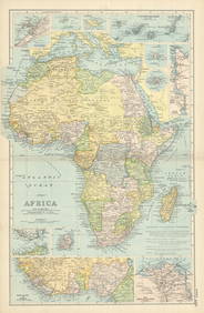
NORTH & COLONIAL WEST AFRICA. Nigeria marked as "Royal Niger Company" 1898 mapJasper524.5(9.8k)See Sold PriceFeb 28, 2024
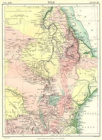
NILE VALLEY. Sudan Tanzania Ethiopia Uganda Lake Victoria. Britannica. 1898 mapJasper524.5(9.8k)See Sold PriceFeb 28, 2024
Algeria Morocco & Tunis. North Africa. Tunisia. Maghreb. BARTHOLOMEW 1898 mapJasper524.5(9.8k)See Sold PriceFeb 28, 2024
COLONIAL CENTRAL AFRICA. Congo German East Africa Rhodesia. BARTHOLOMEW 1898 mapJasper524.5(9.8k)See Sold PriceFeb 28, 2024
AFRICA. Africa. Britannica 9th edition 1898 old antique vintage map plan chartJasper524.5(9.8k)See Sold PriceFeb 28, 2024
AFRICA French Congo State Soudan Nile Delta Suez canal by GW BACON 1898 mapJasper524.5(9.8k)See Sold PriceFeb 28, 2024
Cooke, George 1801 Antique Map. United States of AmericaAlbion Auctions4.6(336)See Sold PriceMar 01, 2024
Vintage Vics Special TOC Advertising Beer SignMatthew Bullock Auctioneers4.7(1.8k)See Sold PriceMar 17, 2024
Carl J. Sundevall (1801 - 1875) Set of 4 Bird Prints - Dove - Woodpecker - DuckProverde Auctions4.3(3)See Sold PriceFeb 28, 2024
Francis McNally - Antique Map of Ohio, Indiana & KentuckyProverde Auctions4.3(3)See Sold PriceFeb 28, 2024
George F. Cram - Historical Map of Pittsburgh Allegheny PennsylvaniaProverde Auctions4.3(3)See Sold PriceFeb 28, 2024
Antique Map of Poland, 1700 by Guillaume De Lisle, ParisAntiques Online Auctions4.6(407)See Sold PriceMar 14, 2024
Jules Verne, L'Archipel en Feu, Au Steamer Red MacaronLion and Unicorn4.7(1.8k)See Sold PriceMar 10, 2024