SoldSayer, New and Complete Map of Scotland, c.1777[Scotland]. [Sayer & Bennett]. A New And Complete Map Of Scotland, And Islands Thereto Belonging; From Actual Surveys, The Shires Properly Divided And Subdivided, The Forts Lately Erected, & Roads OfSee Sold Price
A New and Complete Map of Scotland, And islands theretoIn A General Atlas Published by Robert Sayer, London, 1786-88 BT-263 a: 59.5 cm x 100.5 cm; BT-263 b: 59.5 cm x 100.5 cm Assembled: 119 cm x 100.5 cm Watermarked paper. Original color (shire boundarieSee Sold Price
A New and Complete Map of Scotland,Published by Robert Sayer, London, [1786-88]Assembled: 119 cm x 100.5 cmWatermarked paper. Original color (shire boundaries). Upper sheet has repair at a horizontal fold, as well as some frayed spotsSee Sold Price
New and Complete Map of Scotland, And Islands TheretoTitle: New and Complete Map of Scotland, And Islands Thereto Belonging; Publicaiton Date: 1779 Cartographer: Publisher: ROBT. SAYER Size: 46.7Height - 39.7Width Additional Information: from actual surSee Sold Price
SoldNew and Complete Map of Scotland, And Islands TheretoTitle/Content of Map: New and Complete Map of Scotland, And Islands Thereto Belonging; Cartographer: Date: 1779 Publisher: ROBT. SAYER Size: 46.7Height - 39.7Width "from actual surveys, the Shires proSee Sold Price
Sold[Kitchin (Thomas)] - A New and Complete Map of Scotlandlarge 4-sheet map of Scotland, with inset map of the Shetland Islands, upper right, decorative tile cartouche, upper left, key to place names, lower left, compass rose and numerous ships, engraved mapSee Sold Price
SoldSayer (R.) A new and accurate map of ScotlandSayer (Robert) Publisher.- A new and accurate map of Scotland,with inset map of the Shetland Isles, descriptive key, pictorial title and compass rose, engraved folding map with outline hand-coSee Sold Price
SoldSayer (Robert) - A New Map of the Roads of Englandincluding the roads of northern France to Paris, with inset Continuation of the Roads of Scotland, upper right, title cartouche just below, engraved map with original hand-colouring in outline, 760 xSee Sold Price
The Scotch Itinerary, 1805 scarce first edition.Scarce first edition of an early travel book on Scotland. Complete with original foldout map of Scotland. “The Scotch Itinerary, Containing the Roads Through Scotland, on a New Plan. With Copious obSee Sold Price
SoldScotch Itinerary, 1805 scarce 1st edition.Scarce first edition of an early travel book on Scotland. Complete with original foldout map of Scotland. “The Scotch Itinerary, Containing the Roads Through Scotland, on a New Plan. With Copious obSee Sold Price
Scotch Itinerary, 1805 scarce 1st edition.Scarce first edition of an early travel book on Scotland. Complete with original foldout map of Scotland. “The Scotch Itinerary, Containing the Roads Through Scotland, on a New Plan. With Copious obSee Sold Price
Scotch Itinerary, 1805 scarce 1st edition.Scarce first edition of an early travel book on Scotland. Complete with original foldout map of Scotland. “The Scotch Itinerary, Containing the Roads Through Scotland, on a New Plan. With Copious obSee Sold Price
SoldTEESDALE, HENRY. New British AtlasTEESDALE, HENRY. New British Atlas Containing a *Complete Set of County Maps...Preceded by General Maos of England, Ireland, Scotland, North & South Wales, the Whole Carefully Revised and CorrecteSee Sold Price
SoldA General View of the City & Castle of Edinburgh, tMillar, A General View of the City & Castle of Edinburgh, the Capital of Scotland, engraving, from Millar's New Complete & Universal System of Geography (London, ca. 1780), 12 x 8 12 x 8See Sold Price
Sold1782 Thomas Kitchen atlas,1782 Thomas Kitchen atlas, [A General Atlas Describing the Whole Universe Being a Complete and New Collection of the Most Approved Maps Extant; London 1782,] published by R. Sayer and J. Bennett, 23 eSee Sold Price
SoldBritain.- Cary (John, publisher) Cary's New Map ofBritain.- Cary (John, publisher) Cary's New Map of England and Wales with Part of Scotland, complete with all 81 sheets, engraved map hand-coloured in outline, divided into three sections, each approxSee Sold Price
Sayer: New Map of Spain & Portugal, 1790Map: A New Map of the Kingdoms of Spain and Portugal Publication Date: 1790-06-01 Maker: ROBERT SAYER, Publisher: ROBERT SAYER, Size: Double Folio – 21.25 H x 28.50 W Inches with their principal divSee Sold Price
Sayer. New Map of North America & West IndiesSayer (Robert) A New Map of North America with the West India Islands according to the Preliminary Articles of Peace Signed at Versailles, 20 Jan, 1783,wherein are particularly Distinguished TSee Sold Price
Sold1845 map of Boston[U.S./BOSTON]. A New & Complete Map of the City of Boston With part of Charlestown, Cambridge & Roxbury. From the best of Authorities by G. W. Boynton. Bos: N. Dearborn, 1845. 17 3/8 x 14 3/4, folds iSee Sold Price
Sold(2) 1643 "Nova Totivs Terrarvm Orbis Geopraphica"Size of each: Overall size: 11 3/4 x 14 1/2 in. Sight size: 8 x 6 in. Framed replica of the 1643 World Map titled " Nova Totivs Terrarvm Orbis Geographica" which means "A new complete map of geographySee Sold Price
SoldBOYNTON, BOSTON MAP, ENGRAVING, C.1846Artist: G. W. Boynton, Title: A New & Complete Map of the City of Boston With Part of Charlestown, Cambridge & Roxbury, Printmaker: G. W. Boynton, Pub: Nathaniel Dearborn, Date: C.1846, Medium: EngravSee Sold Price
ROBERT SAYER...A COMPLETE MAP OF THE WEST INDIES, 1776Robert Sayer...A Complete Map Of The West Indies, 1776...40 X 27 1/4 In.... Gallery Stretched Giclée PrintSee Sold Price
SoldJohn Cary. a New Map of Scotland. 1801.Hand Colored Map. 21" x 25" with huge margins. Edge wear which can be easily matted out with large margins still present.See Sold Price
1892 Adams and Bowles New Road Map of the State of New YorkJM Hobby Supply and Railroad Artifact Auctions4.4(127)See Sold PriceFeb 24, 2024
Central Railroad of New Jersey Map of Sandy Hook Route-ca. 1903JM Hobby Supply and Railroad Artifact Auctions4.4(127)See Sold PriceFeb 24, 2024
Lehigh Valley RR 1893 Pass; Delaware and Hudson Canal Co 1875 TicketJM Hobby Supply and Railroad Artifact Auctions4.4(127)See Sold PriceFeb 24, 2024
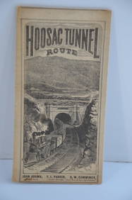
Fitchburg Railroad 1880 Hoosac Tunnel Route Public TimetableJM Hobby Supply and Railroad Artifact Auctions4.4(127)See Sold PriceFeb 24, 2024
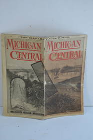
Michigan Central RR May 18, 1884 Public TimetableJM Hobby Supply and Railroad Artifact Auctions4.4(127)See Sold PriceFeb 24, 2024
LATE 16TH C. MAP OF SCOTLAND BY MERCATOR, FRAMEDThomaston Place Auction Galleries4.4(394)See Sold PriceFeb 24, 2024
Portfolio of 15 County Maps by Robert Morden (English 1650-1703)Nadeau's Auction Gallery4.7(410)See Sold PriceFeb 24, 2024
1872 Holy BIBLE & Hitchcock Analysis Gruden Concordance Theology MAPS Holy LandSchilb Antiquarian Rare Books4.8(431)See Sold PriceMar 31, 2024
Keith Haring - Ink on New York Map, Best Buddies, Inscribed, Signed, and DatedSapphire Auction Gallery4.1(67)See Sold PriceMar 02, 2024
U.S. NAVY - A Complete History by Goodspeed, M. Hill 2003 MintNorth American Artifact Auctions4.7(201)See Sold PriceApr 20, 2024
[ARCTIC]. BOWEN, Emanuel. A New & Accurate Map of the North...Potter & Potter Auctions4.6(550)See Sold PriceMar 07, 2024
New and Correct Map of North America With the West India Islands,Jasper524.5(9.9k)See Sold PriceFeb 27, 2024
Herman Moll A New Map of Ye North Parts of AmericaWillow Auction House4.5(292)See Sold PriceMar 14, 2024


![[Kitchin (Thomas)] - A New and Complete Map of Scotland (1 of 1)](https://p1.liveauctioneers.com/410/97080/49498973_1_x.jpg?height=282&quality=70&version=1480351739)


![[Map] New Map of Scotland (1 of 5)](https://p1.liveauctioneers.com/523/84219/43476537_1_x.jpg?height=282&quality=70&version=1453240168)


![[ARCTIC]. BOWEN, Emanuel. A New & Accurate Map of the North... (1 of 1)](https://p1.liveauctioneers.com/928/318880/171360917_1_x.jpg?height=282&quality=70&version=1707501302)