Vintage Ca. 1940's International Panel Delivery Truck Converted into Stationary Food Truck, WasSwisher Bros. Auction LLC4.4(241)See Sold PriceFeb 25, 2024
Martin Custom Acoustic Guitar 000 Body Style Rosewood with Hard CaseHess Fine Auctions4.5(197)See Sold PriceMar 02, 2024
1968 Gibson LG-0 Acoustic Dreadnought Parlor GuitarHess Fine Auctions4.5(197)See Sold PriceMar 02, 2024
Replica Robinson 1862 Sharps CarbineSchmidt's Antiques Inc. Since 19114.8(431)See Sold PriceMar 02, 2024
PAIR (18th c) OF FLINTLOCK DUELING PISTOLSJohn McInnis Auctioneers,LLC4.6(502)See Sold PriceFeb 24, 2024
PAIR T KETLAND of LONDON .60 CAL FLINTLOCK PISTOLSJohn McInnis Auctioneers,LLC4.6(502)See Sold PriceFeb 25, 2024
Gibson ES335 Semi Hollow Vintage Sunburst Electric Guitar with Certificate of Authenticity Hand MadeHess Fine Auctions4.5(197)See Sold PriceMar 02, 2024
WALT DISNEY WORLD - Figment Animatronic Character Skin from EPCOT's Journey Into ImaginationPropstore4.2(6)See Sold PriceMar 12, 2024
Lot Of 3 Early Large Three-Ring Binders Full Of Thousands Of StampsRbfinearts4.4(571)See Sold PriceFeb 24, 2024
A FINE PERSIAN MALAYER PRAYER RUG WITH CYPRESS C. 1860Soulis Auctions4.8(953)See Sold PriceFeb 24, 2024
Thomas Hart Benton; 20thC. American Regionalist Oil SignedMid-Hudson Auction Galleries4.4(468)See Sold PriceFeb 24, 2024
Fender USA Stratocaster Electric Guitar Classic Candy Red and White Original Stickers with Gig BagHess Fine Auctions4.5(197)See Sold PriceMar 02, 2024
1986 Fender Stratocaster Japan Blue-Green with White Pickguard and Gig Bag JapaneseHess Fine Auctions4.5(197)See Sold PriceMar 02, 2024
SoldTenn. Map 1811, Payne/Low"A Map of the Tennassee [sic] Government from the latest Surveys 1810", by John Payne, published by E. Low, New York, 1811. From "A New and Complete Universal Geography", Vol. IV, by John Payne. CoppeSee Sold Price
SoldNorth America Map, 1811 John Russell"North America, Drawn from the Best Authorities" engraved by John Russell, published by Wilkie, Robinson, J. Mawman, London, 1811. From "New System of Modern Geography" by William Guthrie. Copper platSee Sold Price
SOUTH AMERICA MAP - 1811RUSSIA IN EUROPE POSTER. South America. Drawn under the direction of Mr. Pinkerton by L. Hebert. Neele sculpt. 352 Strand. London: published August 1st. 1811, by Cadell & Davies, Strand & Longman, HuSee Sold Price
SoldMalte-Brun: Map of Europe, Barbarian Invasions, 1811Map: 1811 Malte-Brun Map of Europe during the Barbarian Invasions -- L'Europe apres l'invasion des Barbares Cartographer: M Malte-Brun Year / Place: 1811, Paris Map Dimensions: 8.7 X 11.7 An outstandiSee Sold Price
Map of the Battlefield of Baker's Creek, 1892Map: Part of Virginia exhibiting the routes of Gen. W.W. Averell, Map of the Vicinity of New Creek Sta., Map of the Battle-field of Baker's Creek, Field Works at Franklin, Tenn., Map of Tete de Pont aSee Sold Price
Sold1799 Payne/Low Map of "Tennassee"A Map of the Tennassee [sic] Government from the latest Surveys, 1799, by John Payne, published by E. Low, New York, 1799. From "A New and Complete Universal Geography" by John Payne. Copper plate engSee Sold Price
Sold1811 Map of the United States, John CaryAntique hand colored map of part of the United States, engraved by John Cary, 1811. Sight size is 18" tall.See Sold Price
Sold1811 MAP OF THE STATE OF PENNSYLVANIA HAND COLORED1811 MAP OF THE STATE OF PENNSYLVANIA: Powell, Reading (after); Philadelphia: Kimber & Conrad; Map engraved by J. Vallance, with decorative cartouches and inset view of the Schuylkill Permanent BridgeSee Sold Price
SoldWilkes, John 1811 Map. Middlesex LondonCopper Engraved Map Published 1796-1828 London for "Encyclopaedia Londinensis, or universal dictionary of arts, sciences and literature" by John Wilkes et al. Paper Size: 10.5 x 8.5 inch (27 x 22cm) VSee Sold Price
SoldLyttleton, George 1811 Map of The English Channel"Chart of the British Channel with the opposite Coast of the United Kingdom, and the Republic of France" Hand Colored Copper Engraved Map Published 1811, London for "The History of England..." by GeorSee Sold Price
SoldLyttleton, George 1811 Map of Ireland by J. RussellCopper Engraved Map Published 1811, London for "The History of England..." by George Courtney Lyttleton. Folds as issued. Paper Size: 18.5 x 15.5 inch (47 x 39cm) Approx. Some wrinkles. Very minor tonSee Sold Price
SoldLyttleton, George 1811 Map of Spain & PortugalCopper Engraved Map Published 1811, London for "The History of England..." by George Courtney Lyttleton. Folds as issued. Paper Size: 18 x 14 inch (46 x 36cm) Approx. Some wrinkles and minor toning.See Sold Price
SoldWilkes, John 1811 Map. IrelandCopper Engraved Map Published 1796-1828 London for "Encyclopaedia Londinensis, or universal dictionary of arts, sciences and literature" by John Wilkes et al. Paper Size: 10.5 x 8.5 inch (27 x 22cm) GSee Sold Price
SoldRussell, J. 1811 Map of Boulogne, France"Plan of the Harbour and Fortifications of Boulogne" Copper Engraved Map Published 1811, London for "The History of England..." by George Courtney Lyttleton. Folds as issued. Drawn & Engraved by J. RuSee Sold Price
Sold1811 MAP OF NEW ENGLAND SITE SIZE 18" X 20 1/2"1811 MAP OF NEW ENGLAND SITE SIZE 18" X 20 1/2"See Sold Price
Lyttleton, George 1811 Map of England & WalesCopper Engraved Map Published 1811, London for "The History of England..." by George Courtney Lyttleton. Drawn & Engraved by J. Russell. Folds as issued. Paper Size: 18.5 x 16 inch (47 x 40cm) Approx.See Sold Price
ISLINGTON PARISH 1735.Holloway Highgate Crouch End.Scarce. HAWKSWORTH 1811 mapTitle: ISLINGTON PARISH 1735.Holloway Highgate Crouch End.Scarce. HAWKSWORTH 1811 map Description: A survey of the Roads and Foot-paths in the Parish of Islington. From a Plan in the Vestry Room, drawSee Sold Price
Lyttleton, George 1811 Map of River Scheldt Belgium"Sketch of the River Scheldt, from Flushing to Antwerp" Copper Engraved Map Published 1811, London for "The History of England..." by George Courtney Lyttleton. Folds as issued. Paper Size: 21 x 9 incSee Sold Price
Russell, J. 1811 Map of Boulogne, France"Plan of the Harbour and Fortifications of Boulogne" Copper Engraved Map Published 1811, London for "The History of England..." by George Courtney Lyttleton. Folds as issued. Drawn & Engraved by J. RuSee Sold Price
SoldCharles François Delamarche (1740 - 1811), Map ofCharles François Delamarche (1740 - 1811), Map of Jerusalem, 1787, hand painted copperplate on paper, 47 x 66 cm, described lower left: 'partagée selon l'ordre de Dieu aux douze tribus descendantesSee Sold Price
Lyttleton, George 1811 Map of England & WalesCopper Engraved Map Published 1811, London for "The History of England..." by George Courtney Lyttleton. Drawn & Engraved by J. Russell. Folds as issued. Paper Size: 18.5 x 16 inch (47 x 40cm) Approx.See Sold Price
Lyttleton, George 1811 Map of River Scheldt Belgium"Sketch of the River Scheldt, from Flushing to Antwerp" Copper Engraved Map Published 1811, London for "The History of England..." by George Courtney Lyttleton. Folds as issued. Paper Size: 21 x 9 incSee Sold Price
SoldLochhead (Pub) 1811 Rare Map. AfricaCopper Engraved Map Published 1811 by William Lochhead, Berwick for "Modern Geography: And a Compendious General Gazetteer" Rare. Folds as issued. Paper Size: 12 x 10 inch (30 x 26cm) Very minor toninSee Sold Price
SoldLochhead (Pub) 1811 Rare Map. World HemisphereCopper Engraved Map Published 1811 by William Lochhead, Berwick for "Modern Geography: And a Compendious General Gazetteer" Rare. Folds as issued. Paper Size: 17 x 11 inch (43 x 28cm) Some creasing. VSee Sold Price
Central Railroad of New Jersey Map of Sandy Hook Route-ca. 1903JM Hobby Supply and Railroad Artifact Auctions4.4(126)See Sold PriceFeb 24, 2024
Cincinnati Hamilton and Dayton RR Map -USGC 1889JM Hobby Supply and Railroad Artifact Auctions4.4(126)See Sold PriceFeb 24, 2024
Northern Pacific RR Washington and Northern Idaho Map Folder-1941JM Hobby Supply and Railroad Artifact Auctions4.4(126)See Sold PriceFeb 24, 2024
Rand McNally/Santa Fe Railroad Map of Iowa-1912JM Hobby Supply and Railroad Artifact Auctions4.4(126)See Sold PriceFeb 24, 2024
17TH C. WORLD MAP BY NICOLAES VISSCHER (NETHERLANDS, 1618-1709)Thomaston Place Auction Galleries4.4(386)See Sold PriceFeb 24, 2024
LATE 17TH C. FRENCH MAP OF THE NEW WORLD BY ALEXIS-HUBERT JAILLOT (1632-1712)Thomaston Place Auction Galleries4.4(386)See Sold PriceFeb 24, 2024
18TH C. ANTIQUE MAP: FRENCH & INDIAN WAR, FRAMEDThomaston Place Auction Galleries4.4(386)See Sold PriceFeb 24, 2024
NICOLAES VISSCHER (NETHERLANDS, 1618-1709) MAP OF THE NEW WORLDThomaston Place Auction Galleries4.4(386)See Sold PriceFeb 24, 2024
Nova Totius Full Color Geographical World MapThe Benefit Shop Foundation Inc.4.3(2.9k)See Sold PriceFeb 28, 2024
Civil War Map, Positions of the Army of the Ohio Front oh Dalton GA Dated 1864 34"L x 24"TSwisher Bros. Auction LLC4.4(241)See Sold PriceFeb 24, 2024
Keith Haring - Ink on New York Map, Best Buddies, Inscribed, Signed, and DatedSapphire Auction Gallery4(67)See Sold PriceMar 02, 2024
Rand McNally Railroad Map Cabinet w/ 21 Railroad MapsRail & Road Auctions4.6(165)See Sold PriceMar 08, 2024
A MAP OF THE STRAND OF THE NORTH SIDE OF CHANNEL OF RIVER ANNA LIFFE, 1811 Engraving, 680 x 480mmAdam's Auctioneers4.3(5)See Sold PriceFeb 27, 2024
Willem Blaeu, Etc. 17th C. Antiquarian Maps, 2Auctions at Showplace4.5(726)See Sold PriceMar 17, 2024
Putnam - First Map of the State of Ohio by Rufus PutnamTrillium Antique Prints & Rare Books4.5(30)See Sold PriceFeb 24, 2024
De Jode, Rare, pub. 1593 - Map of Africa (Africae Vera Forma, et Situs)Trillium Antique Prints & Rare Books4.5(30)See Sold PriceFeb 24, 2024
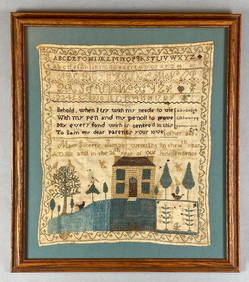
1811 36th Year of Independence Mary Gilbert American Needlepoint SamplerMatthew Bullock Auctioneers4.7(1.8k)See Sold PriceMar 02, 2024