ATLAS of ANTIENT GEOGRAPHY by SAMUEL BUTLER 1843John McInnis Auctioneers,LLC4.6(502)See Sold PriceFeb 24, 2024
18TH C. ANTIQUE MAP: FRENCH & INDIAN WAR, FRAMEDThomaston Place Auction Galleries4.4(386)See Sold PriceFeb 24, 2024
Rand McNally Railroad Map Cabinet w/ 21 Railroad MapsRail & Road Auctions4.6(165)See Sold PriceMar 08, 2024
Keith Haring - Ink on New York Map, Best Buddies, Inscribed, Signed, and DatedSapphire Auction Gallery4(67)See Sold PriceMar 02, 2024
LATE 17TH C. FRENCH MAP OF THE NEW WORLD BY ALEXIS-HUBERT JAILLOT (1632-1712)Thomaston Place Auction Galleries4.4(386)See Sold PriceFeb 24, 2024
Central Railroad of New Jersey Map of Sandy Hook Route-ca. 1903JM Hobby Supply and Railroad Artifact Auctions4.4(126)See Sold PriceFeb 24, 2024
Lot of Six Mixed Atlas Box Cars-HO Scale-New in BoxJM Hobby Supply and Railroad Artifact Auctions4.4(126)See Sold PriceFeb 25, 2024
Rand McNally/Santa Fe Railroad Map of Iowa-1912JM Hobby Supply and Railroad Artifact Auctions4.4(126)See Sold PriceFeb 24, 2024
NICOLAES VISSCHER (NETHERLANDS, 1618-1709) MAP OF THE NEW WORLDThomaston Place Auction Galleries4.4(386)See Sold PriceFeb 24, 2024
17TH C. WORLD MAP BY NICOLAES VISSCHER (NETHERLANDS, 1618-1709)Thomaston Place Auction Galleries4.4(386)See Sold PriceFeb 24, 2024
Lot of Six Mixed Atlas Cabooses-HO Scale-New in BoxJM Hobby Supply and Railroad Artifact Auctions4.4(126)See Sold PriceFeb 25, 2024
SoldWarner Beers: Map of Nevada and California, 1872Map: Atlas Map of the United States Map of Nevada and California Maker: Warner Beers Date: 1872 Origin: Chicago, New York Size: 16.3 x 13.5 inches Very nice map of California and Nevada. This was a tiSee Sold Price
Sold1872 Warner Beers Map of Southern US -- Map of theReserve Reduced! Title/Content of Map: 1872 Warner Beers Map of Southern US -- Map of the Southern States Date: 1872, Chicago Cartographer: Warner Beers Size: 16.7 x 27.3 in. This is a nice large doubSee Sold Price
Sold1872 Warner Beers Map of New England and New York --Title/Content of Map: 1872 Warner Beers Map of New England and New York -- New England and New York Date: 1872, Chicago Cartographer: Warner Beers Size: 13.2 x 16 in. This is a nice map of the new EngSee Sold Price
1872 Warner & Beers Map of the Caribbean -- Map of theTitle: 1872 Warner & Beers Map of the Caribbean -- Map of the West Indies Date: 1872, Chicago Cartographer: Warner & Beers Size: 15.7 x 13.8 in. Additional Information: A highly detailed map of the CaSee Sold Price
1872 Warner Beers Map Western Portion of SouthernTitle/Content of Map: 1872 Warner Beers Map Western Portion of Southern States -- County Map of Tennessee, Kentucky, Alabama. Mississippi, Arkansas and Louisiana Date: 1872, Chicago Cartographer: WarnSee Sold Price
1872 Warner Beers Map of Southern US -- Map of theTitle/Content of Map: 1872 Warner Beers Map of Southern US -- Map of the Southern States Date: 1872, Chicago Cartographer: Warner Beers Size: 16.7 x 27.3 in. This is a nice large double page map of moSee Sold Price
Sold1872 Warner Beers Map Western Portion of SouthernReserve Reduced! Title/Content of Map: 1872 Warner Beers Map Western Portion of Southern States -- County Map of Tennessee, Kentucky, Alabama. Mississippi, Arkansas and Louisiana Date: 1872, Chicago CSee Sold Price
1872 Warner & Beers Map of the Caribbean -- Map of theTitle/Content of Map: 1872 Warner & Beers Map of the Caribbean -- Map of the West Indies Date: 1872, Chicago Cartographer: Warner & Beers Size: 15.7 x 13.8 in. A highly detailed map of the Caribbean,See Sold Price
Sold1872 Warner & Beers Map of the Caribbean -- Map of theTitle/Content of Map: 1872 Warner & Beers Map of the Caribbean -- Map of the West Indies Date: 1872, Chicago Cartographer: Warner & Beers Size: 15.7 x 13.8 in. A highly detailed map of the Caribbean,See Sold Price
1872 Warner & Beers Map of the Caribbean -- Map of theTitle/Content of Map: 1872 Warner & Beers Map of the Caribbean -- Map of the West Indies Date: 1872, Chicago Cartographer: Warner & Beers Size: 15.7 x 13.8 in. A highly detailed map of the Caribbean,See Sold Price
1872 Warner Beers Map of Southern US -- Map of theTitle/Content of Map: 1872 Warner Beers Map of Southern US -- Map of the Southern States Date: 1872, Chicago Cartographer: Warner Beers Size: 16.7 x 27.3 in. This is a nice large double page map of moSee Sold Price
1872 Warner Beers Map of Southern US -- Map of theTitle/Content of Map: 1872 Warner Beers Map of Southern US -- Map of the Southern States Date Printed: 1872, Chicago Cartographer: Warner Beers Size: 16.7 x 27.3 in. This is a nice large double page mSee Sold Price
1872 Warner & Beers Map of the Caribbean -- Map of theTitle/Content of Map: 1872 Warner & Beers Map of the Caribbean -- Map of the West Indies Date Printed: 1872, Chicago Cartographer: Warner & Beers Size: 15.7 x 13.8 in. A highly detailed map of the CarSee Sold Price
1872 Warner & Beers Map of the Caribbean -- Map of theTitle/Content of Map: 1872 Warner & Beers Map of the Caribbean -- Map of the West Indies Date: 1872, Chicago Cartographer: Warner & Beers Size: 15.7 x 13.8 in. A highly detailed map of the Caribbean,See Sold Price
1872 Warner & Beers Map of the Caribbean -- Map of theTitle/Content of Map: 1872 Warner & Beers Map of the Caribbean -- Map of the West Indies Date: 1872, Chicago Cartographer: Warner & Beers Size: 15.7 x 13.8 in. A highly detailed map of the Caribbean,See Sold Price
1872 Warner & Beers Map of the Caribbean -- Map of theTitle: 1872 Warner & Beers Map of the Caribbean -- Map of the West Indies Date: 1872, Chicago Cartographer: Warner & Beers Size: 15.7 x 13.8 in. Additional Information: A highly detailed map of the CaSee Sold Price
1872 Warner Beers Map Western Portion of SouthernTitle/Content of Map: 1872 Warner Beers Map Western Portion of Southern States -- County Map of Tennessee, Kentucky, Alabama. Mississippi, Arkansas and Louisiana Date: 1872, Chicago Cartographer: WarnSee Sold Price
1872 Warner & Beers Map of the Caribbean -- Map of theTitle/Content of Map: 1872 Warner & Beers Map of the Caribbean -- Map of the West Indies Date: 1872, Chicago Cartographer: Warner & Beers Size: 15.7 x 13.8 in. A highly detailed map of the Caribbean,See Sold Price
1872 Warner Beers Map Western Portion of SouthernTitle/Content of Map: 1872 Warner Beers Map Western Portion of Southern States -- County Map of Tennessee, Kentucky, Alabama. Mississippi, Arkansas and Louisiana Date Printed: 1872, Chicago CartographSee Sold Price
1872 Warner & Beers Map of the Caribbean -- Map of theTitle/Content of Map: 1872 Warner & Beers Map of the Caribbean -- Map of the West Indies Date: 1872, Chicago Cartographer: Warner & Beers Size: 15.7 x 13.8 in. A highly detailed map of the Caribbean,See Sold Price
1872 Warner Beers Map of New England and New York --Title/Content of Map: 1872 Warner Beers Map of New England and New York -- New England and New York Date Printed: 1872, Chicago Cartographer: Warner Beers Size: 13.2 x 16 in. This is a nice map of theSee Sold Price
Warner & Beers: Antique Map of the Caribbean, 1872Title/Content of Map: 1872 Warner & Beers Map of the Caribbean -- Map of the West Indies Date Printed: 1872, Chicago Cartographer: Warner & Beers Size: 15.7 x 13.8 in. A highly detailed map of the CarSee Sold Price
Sold1862, 1872 Maps - VA, Southern States1862 Johnson map of Richmond, VA (18 x 27"). 1872 Warner & Beers map of Southern States (29 x 18).See Sold Price
Warner & Beers: Antique Map of the Caribbean, 1872Title/Content of Map: 1872 Warner & Beers Map of the Caribbean -- Map of the West Indies Date Printed: 1872, Chicago Cartographer: Warner & Beers Size: 15.7 x 13.8 in. A highly detailed map of the CarSee Sold Price
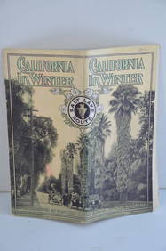
Los Angeles and Salt Lake RR California in Winter Brochure-October 1912JM Hobby Supply and Railroad Artifact Auctions4.4(126)See Sold PriceFeb 24, 2024
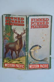
Western Pacific RR Finned Furred Feathered Brochure-1912JM Hobby Supply and Railroad Artifact Auctions4.4(126)See Sold PriceFeb 24, 2024
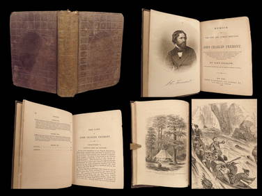
1856 CALIFORNIA 1st ed Memoir John C. Fremont Expeditions Oregon Trail IndiansSchilb Antiquarian Rare Books4.8(421)See Sold PriceMar 10, 2024
EARLY 18TH C. DUTCH CHART OF PACIFIC OCEAN BY FREDERIK DE WIT (1629-1706) WITH CALIFORNIA AS ANThomaston Place Auction Galleries4.4(386)See Sold PriceFeb 24, 2024
Picturesque California, by John Muir, Volume 3, Imperial Japan EditionThe Scanlan Collection4.4(22)See Sold PriceFeb 24, 2024
Bernhardt Wall (CA,1872-1956) watercolor painting antiqueBroward Auction Gallery4.8(277)See Sold PriceMay 05, 2024
ETHEL MARIAN WICKES (California, 1872-1940), Portrait of a seated terrier., Oil on canvas, 20" xEldred's4.7(409)See Sold PriceMar 13, 2024
JOHN EDWARD BOREIN (California, 1872-1945), "Mexico", depicting a woman on horseback and two menEldred's4.7(409)See Sold PriceMar 07, 2024
Chinese Enameled Copper Snuff Box w/ Ivory FiguresArtemis Fine Arts4.8(1.4k)See Sold PriceFeb 26, 2024
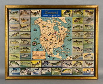
Hamms Air-View Map of Game Fish Advertising Beer PosterMatthew Bullock Auctioneers4.7(1.8k)See Sold PriceMar 02, 2024