SoldBritish Isles.- A large collection of over 140 maps ofNO RESERVE British Isles.- Collection of over 140 maps of England and Wales, many of the north of England, some by Morden, various road strip maps, and many others, engravings and lithographs, variousSee Sold Price
SoldHigh-Quality, Extensive Collection of Maps - Maps ofA large collection containing sixty nine maps of Palestine and the surroundings - numerous woodcuts and engravings from travel and research books of the 18th and 19th centuries (some colored by hand).See Sold Price
SoldLarge copper map engraving plate of birds eye view, 35"Large copper map engraving plate of birds eye view, 35" x 47". Provenance: Property from the Credit Suisse Americana CollectionSee Sold Price
SoldCOLLECTION OF 4 LATE 19TH C MAPS AND 2 ENGRAVINGSINCLUDING 2 LARGE MAPS OF MIDDLEBOROUGH; 1 OF FREETOWN; 2 OF LAKEVILLE AND 2 ENGRAVINGS OF MIDDLEBOROUGH; SOME STAININGSee Sold Price
SoldRare VOYAGES & TRAVELS John Harris 1744Massive two-volume set, Navigantium Atque Itinerantium Bibliotheca, or A Complete Collection of Voyages and Travels. Large folio. 984 pp and 1056 pp. Contains 61 full-plate engravings, 39 of which feaSee Sold Price
SoldLarge Collection of Maps of the Holy Land, Israelites'Large, unique collection of about 75 geographical maps, in color and black and white, of the Holy Land in the 16, 17 and 18th century. The maps were devotedly collected by a dedicated collector for alSee Sold Price
SoldOld Etchings and engravings Moran 1800'slarge collection of engravings and etchings, some say Moran 1800'sSee Sold Price
SoldGeneral Atlas of Engraved Maps, Dr. PlayfairPlayfair, Dr. James (19th Century Scottish), Large Collection of Maps of the World, Including West Indies, The World as Known by the Ancients, France, Sweden, Western Hemisphere, North America, ArabiaSee Sold Price
SoldGiant Collection of Maps of the Holy Land. [63].Impressive, large collection of maps of the Holy Land from different eras. 63 black and white maps, about half were colored at later times, generally in early times. The large majority of the maps areSee Sold Price
SoldLarge Collection of Assorted Maps and Navigation ChartsLarge Collection of Assorted Maps and Navigation Charts, vintage and new, good condition.See Sold Price
SoldA LARGE COLLECTION OF FOLDED MAPS.A LARGE COLLECTION OF FOLDED MAPS. Various dates. Mostly good and clean.See Sold Price
SoldA VERY LARGE COLLECTION OF ANTIQUE ENGRAVINGS ANDA VERY LARGE COLLECTION OF ANTIQUE ENGRAVINGS AND PRINTS of mainly maritime or military themes. (qty)See Sold Price
SoldA large collection of C19th engravings, prints, andA large collection of C19th engravings, prints, and folios of 'The Hundred Best Pictures' published Letts Charles & Co.See Sold Price
SoldAfter Ludovico Carracci (1555-1619) Italian. DancingAfter Ludovico Carracci (1555-1619) Italian. Dancing Maidens, Engraving, Unframed, 14.25” x 8.25”, together with a large collection of various engravings (Q).See Sold Price
SoldPaul Wescott, American (1904-1970), Large collection ofPaul WescottAmerican, (1904-1970)Large collection of Wood Engravings and Linocutsmany designs for bookplates, Christmas cards, and more. Approximately 50 loose engravings.various sizesSee Sold Price
CIVIL WAR ENGRAVED MAPS COLLECTION125. [CIVIL WAR MAP ENGRAVINGS] Collection of eight maps, ca. 1865, various sizes 6"x9" - 7½"x7½", removed from publications. Four are engraved by H. H. Lloyd & Co., NY, including "Ft. Monroe NorfolSee Sold Price
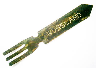
SoldLot of Antique Maps and EtchingsLarge Collection of Russian maps and Misc. Prints and EtchingsSee Sold Price
SoldMappe Monde Restrike Engraving [World Map]Mappe Monde ou Globe Terrestre large restrike color engraving map of the world. From the original plate and created in the third quarter of the 20th century. Measures 21-in. x 27.5-in. image size, 30-See Sold Price
SoldLarge Collection of 19th Century MapsVarious makers, engravers and publishers. See photos for details. Fair to good condition as shown. George CRAM, Johnsons Georgia and Alabama, Johnsons and Ward NEW YORK, J.H. Colton South Carolina andSee Sold Price
SoldLARGE COLLECTION OF GASOLINE ROAD MAPSAPPROX 100. INCLUDING GULF, TEXACO, STANDARD, MOBILOIL, SHELL, PHILLIPS 66, CHEVRON, STANDARD, FLYING A, & MORESee Sold Price
SoldLarge collection of unframed prints, engravings,Large collection of unframed prints, engravings, etc.See Sold Price
Large Topographic Engraving Antique French map ofBasset ( Rue Jacque) edited and published this topographic map of Switzerland ( la Suisse ) Herisson eleve de Bonne is the cartographer , Rigobert Bonne (1727-1794) is a French geographer, hydrographeSee Sold Price
SoldLarge Antique Bound Folio Petrus Aquila EngravingsLarge Antique Bound Folio Petrus Aquila Engravings. Large bound folio collection of engravings including those by Petrus Aquila after Carol Marattus, Ces. Fantettus, Petrus Aquila, and Cefar Fantect,See Sold Price
SoldPicasso 347 Book in original casePicasso 347 Book. New York: Random House ca. 1970, One large volume, collection of 347 engravings by Picasso, illustrated in black and white, housed in a black and white linen slipcase, the whole measSee Sold Price
LARGE GULF SERVICE STATION MAP COLLECTION WITH DISPLAY STAND.Dan Morphy Auctions4.2(1.3k)See Sold PriceFeb 24, 2024
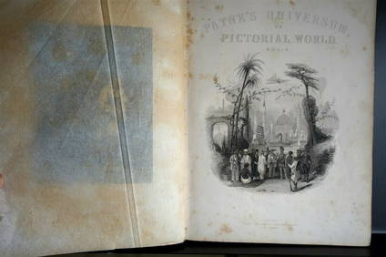
PAYNES UNIVERSUM ca1850 Calf 1st ed Travel 65 X Engravings China etc.Luis Porretta Fine Arts4.3(10)See Sold PriceMar 02, 2024
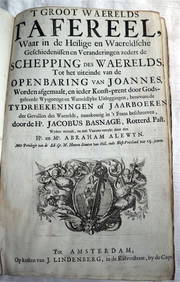
ACOBUS BASAGNE c1710 Theological History Numerous Engravings by De Hooghe Rare!Luis Porretta Fine Arts4.3(10)See Sold PriceMar 02, 2024
99 x EAGLE Dan Dare Comics 1958-1961 All VGC UK Scarce!Luis Porretta Fine Arts4.3(10)See Sold PriceMar 02, 2024
PLAYHOUR UK Children's Comic 75 x Issues c1953-55Luis Porretta Fine Arts4.3(10)See Sold PriceMar 02, 2024
John Boydell / Carlo Dolci 1768 Scarce Engraving Death of St Andrew 17" x 12"Luis Porretta Fine Arts4.3(10)See Sold PriceMar 02, 2024
PETER MAX Original Serigraph Figural Woman In Pink 245/300 Signed 1989Luis Porretta Fine Arts4.3(10)See Sold PriceMar 02, 2024
VENET / DEBUCOURT (1755-1832) Set 3 x Aquatint Engraved Hunting Scenes 23" x 16"Luis Porretta Fine Arts4.3(10)See Sold PriceMar 02, 2024
CHARLES ROLLIN c1828 Ceasar Hand Colored Africa Military MapLuis Porretta Fine Arts4.3(10)See Sold PriceMar 02, 2024
Joseph Martin Kronheim Pair Early Color Glamor Prints c1850Luis Porretta Fine Arts4.3(10)See Sold PriceMar 02, 2024
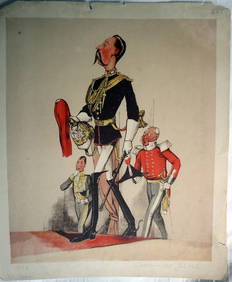
JOSEPH MARTIN KRONHEIM - "Captain Of The Blues" Early Colore Printing MilitaryLuis Porretta Fine Arts4.3(10)See Sold PriceMar 02, 2024
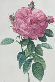
Redoute, Rare, Large Folio - Rose - Rosa Gallica flore giganteoTrillium Antique Prints & Rare Books4.5(33)See Sold PriceFeb 24, 2024
1816 MAP NORTHERN PART OF RUSSIA or MUSCOVY in EUROPE copper engraving ANTIQUEJasper524.5(9.9k)See Sold PriceFeb 28, 2024
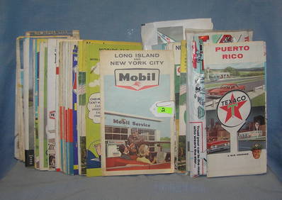
Collection of vintage auto related travel mapsBaker's Antiques and Auctions3.2(472)See Sold PriceFeb 25, 2024
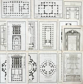
Jean-Francois de Neufforge (1714 - 1791) - Set of 15 Architecture Prints - Development pour unProverde Auctions4.3(3)See Sold PriceFeb 28, 2024
Jean-Francois de Neufforge (1714 - 1791) - Set of 15 Architecture Prints - Plan de l' EdificeProverde Auctions4.3(3)See Sold PriceFeb 28, 2024
Framed Collection Engravings & A Map From The Excursions In The County Of Sussex Published In 1822Rapid Estate Liquidators and Auction Gallery4.5(1.1k)See Sold PriceMar 01, 2024


![Giant Collection of Maps of the Holy Land. [63]. (1 of 8)](https://p1.liveauctioneers.com/2398/67044/34090605_1_x.jpg?height=282&quality=70&version=1422475336)


![Mappe Monde Restrike Engraving [World Map] (1 of 3)](https://p1.liveauctioneers.com/5755/161739/81664913_1_x.jpg?height=282&quality=70&version=1581557184)