SoldWORLD MAP HAND COLORED ENGRAVINGWORLD MAP HAND COLORED ENGRAVING MARKED NIC. GEILEKERCK, DATED 1615. Height: 32 and 22 in. by Width: 40 and 30 in. by Depth: 1 1/2 in.See Sold Price
SoldWORLD MAP HAND COLORED ENGRAVINGWORLD MAP HAND COLORED ENGRAVING, MARKED THOMAS COWERPENTH WAIT.CO. PHILADELPHIA. CIRCA 1850. Height: 18 1/2 and 12 in. by Width: 24 and 15 in. by Depth: 1 in.See Sold Price
SoldMap of the World, Hand Colored EngravingMap of the world, French, hand-colored engraving, titled "L'Ancien Monde et Le Nouveau: En Deux Hemispheres"; 9 1/2" h x 17 1/4" w (view), 14 7/8" h x 22 1/2" w (frame).See Sold Price
SoldRussell Map of the World Hand-Colored Engraving ca 1815J.C. Russell "Map of the World", London, ca. 1815 CE. A world map with striking engraving and hand-coloring, probably from "Russell's General Atlas of Modern Geography. Composed from the Latest & BestSee Sold Price
SoldWorld Map - Hand-Colored Engraving - England, 17thA Mapp or Generall Carte of the World Designed in two Plaine Hemisphers, by Monsieur Sanson Geographr to the French King and Rendered into English and Illustrated with Figures by Richard Blome By theSee Sold Price
SoldJOHN SPEED (BRITISH, 1552-1629) MAP OF THE WORLDJOHN SPEED (BRITISH, 1552-1629) MAP OF THE WORLD, hand-colored engraving on paper, titled "A New and Accurat Map of the World Drawne according to ye truest Descriptions latest Discoveries & best obserSee Sold Price
SoldJOHN SPEED "A NEW AND ACCURATE MAP OF THE WORLD,"JOHN SPEED "A NEW AND ACCURATE MAP OF THE WORLD," HAND COLORED ENGRAVING, DATED 1651, a twin-hemisphere map of the world entitled ''A New and Accurat Map of The World Drawne according to ye truest DesSee Sold Price
SoldJOHANN BAPTIST HOMANN (GERMAN, 1664-1724) MAP OF THEJOHANN BAPTIST HOMANN (GERMAN, 1664-1724) MAP OF THE WORLD hand-colored engraving on laid paper, "Planiglobii Terrestris Cum Utroq Hemisphaerio Caelesti Generalis Exhibito", published in Nuremburg. ReSee Sold Price
SoldA General Map of the World.A General Map of the World. Hand-colored engraving on four joined sheets, published by Laurie & Whittle, London, 1794 Overall: 40.75" x 48.25" Frame: 48.5" x 55.5"See Sold Price
SoldJOHANN BAPTIST HOMANN (GERMAN, 1664-1724) MAP OF THEJOHANN BAPTIST HOMANN (GERMAN, 1664-1724) MAP OF THE WORLD, hand-colored engraving on paper, titled "Planiglobii Terrestris Cum Utroq Hemisphaerio Caelesti Generalis Exhibito". Published in Nuremburg,See Sold Price
SoldWILLIAM GUTHRIE (1708-1770) WORLD MAPWILLIAM GUTHRIE (1708-1770) WORLD MAP, hand-colored engraving on paper, titled "A Map of the World from the best Authorities", published June 15th, 1785 by C. Dilly and G. Robinson, London. Detailed mSee Sold Price
SoldJACQUES-NICOLAS BELLIN (FRENCH, 1703-1772) MAP OF THEJACQUES-NICOLAS BELLIN (FRENCH, 1703-1772) MAP OF THE WORLD hand-colored engraving on laid paper, "Essay D'une Carte Reduite Contenant Les Parties Connues Du Globe Terrestre", from La Harpe's "AbregeSee Sold Price
SoldANTONIO ZATTA (ITALIAN, D. 1794) MAP OF THE WORLDANTONIO ZATTA (ITALIAN, D. 1794) MAP OF THE WORLD, hand-colored engraving on paper, titled "Il Mappamondo o sia Descrizione Generale del Globo Riodotto in Quadro". Published in Venice, 1774. Retains eSee Sold Price
SoldHomann Heirs (German, 18th c.) World MapHomann Heirs (German, 18th c.) , "Planiglobii Terrestris Mappa Universalis...", double page, double hemisphere, world map, hand-colored copper engraving, 1746, with four hemispheric projections, two cSee Sold Price
SoldWorld Map, Dated 1782World map, dated 1782, hand colored engraving, for Miller's New Universal System of Geography, 12 1/2" h x 18 1/2" w (view), 20" h x 26" w (frame). Provenance: CA estate.See Sold Price
SoldAfter Van Geelkercken, Orbis Terrarum MapAfter Nicholas (Nicolaes) van Geelkercken (Netherlandish, circa 1585-1656), "Orbis Terrarum Descriptio Duobis Planis Hemisphaeriis Comprehesa", hand colored world map on paper. Hand colored engravingSee Sold Price
Sold19th c. hand colored World Map engravingLate 19th century hand colored engraving of a Map of the World, overall size including frame 24"h x 32.5"w.See Sold Price
SoldAssorted hand-colored world map engravings including 15(lot of 30) Assorted hand-colored world map engravings including 15 printed by Antonio Zatta in Venice, circa 1781. From his master work, "Atlante Novissimo." Images approx 15.5"h x 12"w, on sheets thSee Sold Price
SoldJOHN SPEED (BRITISH, 1552-1629) MAP OF THE WORLDJOHN SPEED (BRITISH, 1552-1629) MAP OF THE WORLD, (UPDATED 6/14/16) hand-colored engraving on laid paper, titled "A New and Accurat Map of the World Drawne according to ye truest Descriptions latest DSee Sold Price
SoldEnsign Map of the WorldT. & E.H. Ensign: "Map of The World, On Mercators Projection", Hand colored copper plate engraving, published by T. & E.H. Ensign, New York: 1844. Geographical Part Engraved by John M. Atwood. PhelpsSee Sold Price
SoldBellin Antique 1748 World Map, FrenchJ. N. Bellin 1748 Antique map of the world, engraving with hand colored decorative title cartouche and compass rose, dated 1748 and dedicated to Charlevoix's patron, Jean Frederic Phelippeux, Comte deSee Sold Price
SoldAfter Hendrik Hondius World Map, 1649After Hendrik Hondius World Map, 1649. A 20th century restrike, hand colored engraving. Map titled "Nova Totius Terrarum Orbis Geographica AC Hydpographica Tabula". Map measures 22" x 15.5" image sizeSee Sold Price
SoldMathew Carey (19th c.mapmaker) "A Map of the WorlMathew Carey (19th c.mapmaker) "A Map of the World from the best Authorities," hand colored copper engraving, ca. 1818, 12"x 21," framed 25"x 34," label verso, Shows the track of Captain Cooks voyagesSee Sold Price
SoldPierre Mortier World MapPierre Mortier World Map, Carte Generale de Toute les Costes du Monde et les pays Norwellemat Decouvat (1700's). Medium: Hand-colored engraving. Size: 32" x 44.5" (frame); 23.5" x 36" (sight). ProvenaSee Sold Price
17TH C. WORLD MAP BY NICOLAES VISSCHER (NETHERLANDS, 1618-1709)Thomaston Place Auction Galleries4.4(386)See Sold PriceFeb 24, 2024
LATE 17TH C. FRENCH MAP OF THE NEW WORLD BY ALEXIS-HUBERT JAILLOT (1632-1712)Thomaston Place Auction Galleries4.4(386)See Sold PriceFeb 24, 2024
17TH C. ANTIQUE MAP SIEGE OF LA ROCHELLE, FRANCE, FRAMEDThomaston Place Auction Galleries4.4(386)See Sold PriceFeb 24, 2024
NICOLAES VISSCHER (NETHERLANDS, 1618-1709) MAP OF THE NEW WORLDThomaston Place Auction Galleries4.4(386)See Sold PriceFeb 24, 2024
MAP OF SALZBURG BY GEORGE BRAUN & FRANS HOGENBURG. 1588Thomaston Place Auction Galleries4.4(386)See Sold PriceFeb 24, 2024
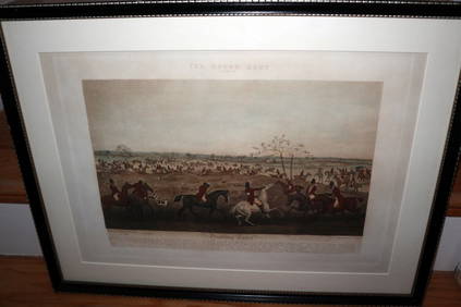
HENRY ALKEN / LEWIS Original 1835 Hand Colored Engraving Quorn Hunt DrawingLuis Porretta Fine Arts4.3(10)See Sold PriceMar 02, 2024
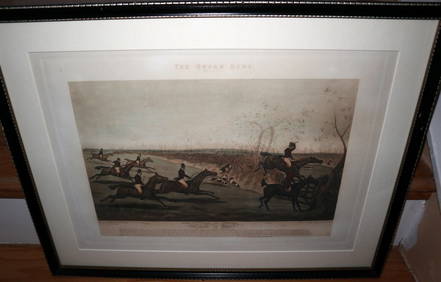
HENRY ALKEN / LEWIS Original 1835 Hand Colored Engraving Quron Hunt Snob Is BeatLuis Porretta Fine Arts4.3(10)See Sold PriceMar 02, 2024
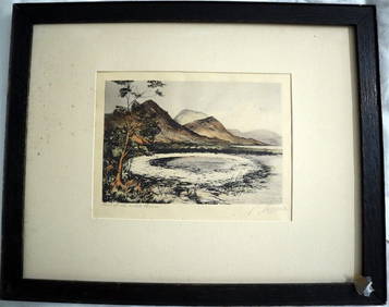
PHILIP NORMAN FSA Hand Colored Engraving c1910 Loch White Fairies SIGNED Listed ScotlandLuis Porretta Fine Arts4.3(10)See Sold PriceMar 02, 2024
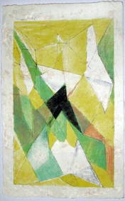
JAQUES VILLON (1875-1963) Hand Colored Cubist Lithograph ca1950Luis Porretta Fine Arts4.3(10)See Sold PriceMar 02, 2024
An early Dutch hand colored engraving map by Georg Balthasar Probst (1732-1801)Ostantix Auctions4.4(10)See Sold PriceFeb 27, 2024
18th Century Hess Germany Hand colored Engraved MapGlobal Auctions Company4.3(36)See Sold PriceMar 03, 2024
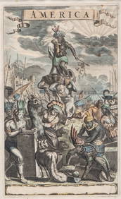
Antique Hand Colored Print "America" by Jacob van MeursCollective Hudson4.5(54)See Sold PriceMar 01, 2024
Johann Homann Hand-Colored Map Engraving, c. 1730Auctions at Showplace4.5(726)See Sold PriceMar 17, 2024
1849 Hand Colored Blair Map of World in HemispheresMatthew Bullock Auctioneers4.7(1.8k)See Sold PriceMar 02, 2024