Asher & Adams California and Nevada, 1872Map: California and Nevada North Portion 1872 Maker: Asher & Adams Size: Double Folio, 16.5 inches high 23.50 inches wide Date: 1872 Extensively developed compared to southern half, especially S.F. BaSee Sold Price
Sold1872 Asher and Adams Map of Southern California andTitle/Content of Map: 1872 Asher and Adams Map of Southern California and Nevada -- Asher & Adams' California & Nevada Southern Portion Date: 1872 New YorkCartographer: Asher & Adams Size: 15.8 x 22.8See Sold Price
1872 Asher and Adams Map of Southern California andTitle/Content of Map: 1872 Asher and Adams Map of Southern California and Nevada -- Asher & Adams' California & Nevada Southern Portion Date: 1872 New York Cartographer: Asher & Adams Size: 15.8 x 22.See Sold Price
1872 Asher and Adams Map of Southern California andReserve Reduced! Title/Content of Map: 1872 Asher and Adams Map of Southern California and Nevada -- Asher & Adams' California & Nevada Southern Portion Date: 1872 New York Cartographer: Asher & AdamsSee Sold Price
SoldAsher & Adams, "California and Nevada, South Portion,"Asher & Adams, "California and Nevada, South Portion," 1872,hand colored, H. - 17 3/8 in., W. - 24 5/8 in.See Sold Price
1872 Asher and Adams Map of Southern California andTitle: 1872 Asher and Adams Map of Southern California and Nevada -- Asher & Adams' California & Nevada Southern Portion Date: 1872 New York Cartographer: Asher & Adams Size: 15.8 x 22.8 in. AdditionaSee Sold Price
Sold3 Maps: CALIFORNIA & NEVADA + OREGON.[United States/West]. Asher & Adams. 3 Maps, lithographs in colors, each with center fold, few small spots, very good condition, slightly toned. ++ CALIFORNIA & NEVADA. NORTH PORTION. 1872. 16 ½ x 23See Sold Price
Asher & Adams' California and Nevada Northern PortionPublication Date: 1872 Title: Asher & Adams' California and Nevada Northern Portion Cartographer: ASHER & ADAMS Publisher: ASHER & ADAMS Height: 16.5 Width: 23 Map showing northern CA & NV. Details coSee Sold Price
Sold9 maps of western US. 7 publ Asher & Adams, (1872[United States: West]. 9 Maps. ++ A New Map Of Nebraska, Kansas, New Mexico And Indian Territories. From ''A New Universal Atlas,'' DeSilver, 1857. ++ A New Map Of The State Of California, The TerritoSee Sold Price
SoldPainting, Edwin M. Dawes, Landscape in Pastel TonFramed oil on canvas, Landscape in Pastel Tones, by Edwin M. Dawes (California/Nevada, 1872-1945), signed ''Edwin M. Dawes'' lower left, sight: 19.75''h x 23.625''w, overall: 26''h x 30''wSee Sold Price
SoldASHER & ADAMS. New Statistical and TopographicalASHER & ADAMS New Statistical and Topographical Atlas of the United States. With Maps Showing The Dominion of Canada, Europe and the World. New York: Asher & Adams, (1872). Folio, original quarter morSee Sold Price
SoldPainting, Edwin M. Dawes, Autumn Trees and MeadowFramed oil on canvas, Early Autumn Trees and Meadow, by Edwin Munot Dawes (California/Nevada, 1872-1945), signed ''Edwin M. Dawes'' lower right, sight: 15.5''h x 21.75''w, overall: 19.75''h x 25.9''wSee Sold Price
SoldPainting, Edwin M. Dawes, Footpath in Summer LandFramed oil on canvas, Footpath through a Summer Landscape, 1913, by Edwin Munot Dawes (California/Nevada, 1872-1945), signed and dated ''Edwin M. Dawes 1913'' lower left, sight: 23.5''h x 29.5''w, oveSee Sold Price
SoldPainting, Edwin M. Dawes, River in Autumn LandscaFramed oil on canvas, Calm River in an Autumn Landscape, by Edwin Munot Dawes (California/Nevada, 1872-1945), signed ''Edwin M. Dawes'' lower left, sight: 23.5''h x 35.5''w, overall: 27.75''h x 39.625See Sold Price
Sold1872 Asher and Adams Map of Eastern Texas -- Asher &Reserve Reduced! Title/Content of Map: 1872 Asher and Adams Map of Eastern Texas -- Asher & Adams' Texas Date: 1872 New York Cartographer: Asher & Adams Size: 22.2 X 15.8 in. A very nice, large map ofSee Sold Price
Sold1872 Asher and Adams Map of Florida -- Asher & Adams'Title/Content of Map: 1872 Asher and Adams Map of Florida -- Asher & Adams' Florida Date: 1872 New York Cartographer: Asher & Adams Size: 15.8 x 22.8 in. A very nice, large map of Florida. The major cSee Sold Price
Sold1872 Asher & Adams Map of Michigan -- Asher & Adams'Title/Content of Map: 1872 Asher & Adams Map of Michigan -- Asher & Adams' Michigan Date: 1872, New York Cartographer: Asher & Adams Size: 22.2 x 16 in. This is a fantastic, very large double page mapSee Sold Price
1872 Asher and Adams Map of Illinois -- Asher & Adams'sTitle/Content of Map: 1872 Asher and Adams Map of Illinois -- Asher & Adams's Illinois Date: 1872 New York Cartographer: Asher & Adams Size: 22.2 X 15.8 in. A very nice, large map of Illinois. The majSee Sold Price
1872 Asher and Adams Map of Eastern Texas -- Asher &Title/Content of Map: 1872 Asher and Adams Map of Eastern Texas -- Asher & Adams' Texas Date: 1872 New York Cartographer: Asher & Adams Size: 22.2 X 15.8 in. A very nice, large map of the Eastern portSee Sold Price
Sold1872 Asher and Adams Map of Wisconsin -- Asher &Title/Content of Map: 1872 Asher and Adams Map of Wisconsin -- Asher & Adams's Wisconsin Date: 1872 New York Cartographer: Asher & Adams Size: 15.8 x 22.8 in. A very nice, large map of Wisconsin. TheSee Sold Price
1872 Asher & Adams Map of Minnesota -- Asher & Adams'Title/Content of Map: 1872 Asher & Adams Map of Minnesota -- Asher & Adams' Minnesota Date: 1872, New York Cartographer: Asher & Adams Size: 22.4 x 16.1 in. This is a fantastic, very large double pageSee Sold Price
Sold1872 Asher and Adams Map of Kentucky & Tennessee --Title: 1872 Asher and Adams Map of Kentucky & Tennessee -- Asher & Adams' Kentucky & Tennessee Cartographer: Asher & Adams Date: 1872 New York Size: 15.8 x 22.8 in. Additional Information: A very niceSee Sold Price
Sold9 maps: World, North America, Carribean. (1856-72[Miscellany]. 10 Maps, hand-colored, very good condition, some light toning in margins, few short tears. ++ Asher & Adams' Europe. c.1872. ++ Asher & Adams' World: On Mercator's Projection. ++ The WesSee Sold Price
1872 Asher and Adams Map of Oregon -- Asher & Adams'Reserve Reduced! Title/Content of Map: 1872 Asher and Adams Map of Oregon -- Asher & Adams' Oregon Date: 1872 New York Cartographer: Asher & Adams Size: 15.8 x 22.8 in. A very nice, large map of OregoSee Sold Price
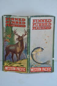
Western Pacific RR Finned Furred Feathered Brochure-1912JM Hobby Supply and Railroad Artifact Auctions4.4(126)See Sold PriceFeb 24, 2024
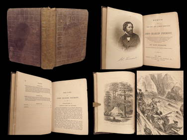
1856 CALIFORNIA 1st ed Memoir John C. Fremont Expeditions Oregon Trail IndiansSchilb Antiquarian Rare Books4.8(421)See Sold PriceMar 10, 2024
Yerba Buena by Vanderslice Sterling Silver Flatware Set 41 pcs California SilverMynt Auctions4.6(680)See Sold PriceFeb 24, 2024
Picturesque California, by John Muir, Volume 3, Imperial Japan EditionThe Scanlan Collection4.4(22)See Sold PriceFeb 24, 2024
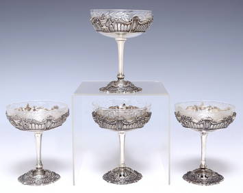
(4) AMERICAN SHREVE & CO. STERLING & GLASS-LINED SHERBET DESSERT CUPSAustin Auction Gallery4.7(1.2k)See Sold PriceFeb 25, 2024
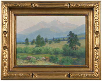
Bernhardt Wall (CA,1872-1956) watercolor painting antiqueBroward Auction Gallery4.8(277)See Sold PriceMay 05, 2024
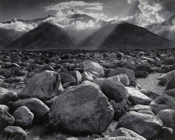
Ansel Adams Ice On Ellery Lake Sierra Nevada CA Custom Framed PrintMynt Auctions4.6(680)See Sold PriceFeb 25, 2024
ETHEL MARIAN WICKES (California, 1872-1940), Portrait of a seated terrier., Oil on canvas, 20" xEldred's4.7(409)See Sold PriceMar 13, 2024
Yerba Buena by Vanderslice Sterling Silver Flatware Set 41 pcs California SilverMynt Auctions4.6(680)See Sold PriceFeb 28, 2024
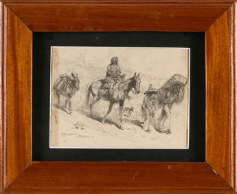
JOHN EDWARD BOREIN (California, 1872-1945), "Mexico", depicting a woman on horseback and two menEldred's4.7(409)See Sold PriceMar 07, 2024
Chinese Enameled Copper Snuff Box w/ Ivory FiguresArtemis Fine Arts4.8(1.4k)See Sold PriceFeb 26, 2024
1872 Round California Gold Quarter NGC MS64 BG-814Gold Standard Auctions4.5(762)See Sold PriceApr 14, 2024