SoldMAP TRACINGS USED FOR D-DAY LANDINGS AT UTAH AND OMAHAMAP TRACINGS USED FOR D-DAY LANDINGS AT UTAH AND OMAHA BEACHES Lot of four 13"" x 14"" pieces of tracing paper printed with late corrections to nautical maps showing fortifications obstacles etc. usedSee Sold Price
SoldMAP TRACINGS USED FOR D-DAY LANDINGS AT UTAH AND OMAHAMAP TRACINGS USED FOR D-DAY LANDINGS AT UTAH AND OMAHA BEACHES Lot of four 13"" x 14"" pieces of tracing paper printed with late corrections to nautical maps showing fortifications obstacles etc. usedSee Sold Price
SoldMAP TRACINGS USED FOR D-DAY LANDINGS AT UTAH AND OMAHAMAP TRACINGS USED FOR D-DAY LANDINGS AT UTAH AND OMAHA BEACHES Lot of four 13" x 14" pieces of tracing paper printed with late corrections to nautical maps showing fortifications, obstacles, etc., useSee Sold Price
MAP TRACINGS USED FOR D-DAY LANDINGS AT UTAH AND OMAHAMAP TRACINGS USED FOR D-DAY LANDINGS AT UTAH AND OMAHA BEACHES Lot of four 13" x 14" pieces of tracing paper printed with late corrections to nautical maps showing fortifications, obstacles, etc., useSee Sold Price
MAP TRACINGS USED FOR D-DAY LANDINGS AT UTAH AND OMAHAMAP TRACINGS USED FOR D-DAY LANDINGS AT UTAH AND OMAHA BEACHES Lot of four 13" x 14" pieces of tracing paper printed with late corrections to nautical maps showing fortifications, obstacles, etc., useSee Sold Price
MAP TRACINGS USED FOR D-DAY LANDINGS AT UTAH AND OMAHAMAP TRACINGS USED FOR D-DAY LANDINGS AT UTAH AND OMAHA BEACHES Lot of four 13" x 14" pieces of tracing paper printed with late corrections to nautical maps showing fortifications, obstacles, etc., useSee Sold Price
MAP TRACINGS USED FOR D-DAY LANDINGS AT UTAH AND OMAHAMAP TRACINGS USED FOR D-DAY LANDINGS AT UTAH AND OMAHA BEACHES Lot of four 13" x 14" pieces of tracing paper printed with late corrections to nautical maps showing fortifications, obstacles, etc., useSee Sold Price
SoldMAP TRACINGS USED FOR D-DAY LANDINGSMAP TRACINGS USED FOR D-DAY LANDINGS Lot of four 13" x 14" pieces of tracing paper printed with late corrections to nautical maps showing fortifications, obstacles, etc., used in the American and BritSee Sold Price
SoldMAP TRACINGS USED FOR D-DAY LANDINGS AT GOLD, JUNO ANDMAP TRACINGS USED FOR D-DAY LANDINGS AT GOLD, JUNO AND SWORD BEACHES Lot of four 13" x 14" pieces of tracing paper printed with late corrections to nautical maps showing fortifications, obstacles, etcSee Sold Price
SoldD-DAY PRE-LANDING BULLETIN FROM OMAHA AND UTAH NAVALD-DAY PRE-LANDING BULLETIN FROM OMAHA AND UTAH NAVAL COMMANDER Historic bulletin issued by Adm. Allan G. Kirk as Navy Commander, Western Task Force, 26pp. legal folio including four fold-out maps, [n.See Sold Price
SoldOMAHA BEACH INVASION PLANS AND MAP OVERLAYS, USED BY ANOMAHA BEACH INVASION PLANS AND MAP OVERLAYS, USED BY AN OFFICER WHO LANDED ON D-DAY Historic set of plans for OPERATION NEPTUNE, the D-Day landings in Normandy on June 6, 1944, this set specifically pSee Sold Price
SoldOMAHA AND UTAH BEACHES CONTOUR AND GRADIENT DRAWINGSOMAHA AND UTAH BEACHES CONTOUR AND GRADIENT DRAWINGS Important set of eight printed drawing and tracings depicting the contour and gradients, or "rise" of the American landing beaches OMAHA and UTAH,See Sold Price
SoldD-DAY BOMBARDMENT PLANS FOR OMAHA AND UTAH BEACHESD-DAY BOMBARDMENT PLANS FOR OMAHA AND UTAH BEACHES Rare printed map: "AMERICAN NEPTUNE AREA BATTERY BOMBARDMENT PLAN", 15" x 13", marked: "TOP SECRET BIGOT", prepared for the invasion of Normandy andSee Sold Price
OMAHA AND UTAH BEACHES CONTOUR AND GRADIENT DRAWINGSOMAHA AND UTAH BEACHES CONTOUR AND GRADIENT DRAWINGS Important set of four eight printed drawing and tracings depicting the contour and gradients, or "rise" of the American landing beaches OMAHA and USee Sold Price
SoldD-Day Invasion: Operation Bigot Omaha Beach Map.D-Day Invasion: August 1944 Allied Landing Map. 21.75" x 28.75" military map of beachheads in Provence, part of Operation Dragoon, mounted to board and housed in a simple inexpensive frame. Issued subSee Sold Price
SoldUTAH BEACH SOUTH - INVASION MAP OF LANDING CRAFT ANDUTAH BEACH SOUTH - INVASION MAP OF LANDING CRAFT AND BEACH DEFENSES Highly important and historical map intended for use in the D-Day invasion of France in Normandy. The map, titled "UTAH BEACH-SOUTHSee Sold Price
SoldFRENCH COAST PHOTO BOOK USED IN D-DAY LANDINGSFRENCH COAST PHOTO BOOK USED IN D-DAY LANDINGS An important relic of the D-Day landings, a 'concertina-style' beach silhouette books containing a series of connected photographs showing the Normandy bSee Sold Price
FRENCH COAST PHOTO BOOK USED IN D-DAY LANDINGSFRENCH COAST PHOTO BOOK USED IN D-DAY LANDINGS An important relic of the D-Day landings, a 'concertina-style' beach silhouette books containing a series of connected photographs showing the Normandy bSee Sold Price
General JAMES VAN FLEET - Book Photo SignedJames Van Fleet (1892-1992) General. Van Fleet commanded the 8th Infantry Regiment for three years and led it into combat in Europe in World War II, participating in the D-Day landings on Utah Beach iSee Sold Price
General JAMES VAN FLEET - Book Photo SignedJames Van Fleet (1892-1992) General. Van Fleet commanded the 8th Infantry Regiment for three years and led it into combat in Europe in World War II, participating in the D-Day landings on Utah Beach iSee Sold Price
SoldWWII ESCAPE AND EVASION C/D MAP D-DAY USED WW2C/D map used during the battle of D-Day. Side C features Holland,. Belgium, (except west coast) France (North East), Germany (West & Central). SIde D features France (South East) Germany (South West),See Sold Price
SoldWW2 US Bigot D-DAY Map, Omaha Beach West, 1944World War Two, US Bigot D-Day Map, Omaha Beach (1pc). A rare "TOP SECRET-BIGOT" Map of "Omaha Beach--West" (Vierville-sur-Mer) as prepared by Commander Task Force 122, April 1944. This map features whSee Sold Price
SoldWWII D-DAY MAP OMAHA BEACH SECTOR DOG & CHARLIEWWII D-DAY MAP OMAHA BEACH SECTOR DOG & CHARLIE From Rear Admiral George B.H. Stallings Archive; map of Omaha Beach, sectors Dog and Charlie. Rear Admiral George B.H. Stallings served in the Navy DepaSee Sold Price
SoldWWII Naval Invasion Inflatable Life Belt made byWWII Naval Invasion Inflatable Life Belt made by Sparklets it is the type used at D-day landing. Missing a rubber inflate hose.See Sold Price
Northern Pacific RR Washington and Northern Idaho Map Folder-1941JM Hobby Supply and Railroad Artifact Auctions4.4(127)See Sold PriceFeb 24, 2024
Rand McNally Railroad Map of Colorado-1929JM Hobby Supply and Railroad Artifact Auctions4.4(127)See Sold PriceFeb 24, 2024
Rock Island RR Iowa and Minnesota Lakes Country Brochure-1926JM Hobby Supply and Railroad Artifact Auctions4.4(127)See Sold PriceFeb 24, 2024
Union Pacific RR Across The Continent West From Omaha, NE Book-April 2, 1868JM Hobby Supply and Railroad Artifact Auctions4.4(127)See Sold PriceFeb 24, 2024
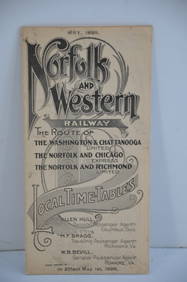
Norfolk and Western RY May 1898 Public TimetableJM Hobby Supply and Railroad Artifact Auctions4.4(127)See Sold PriceFeb 24, 2024
17TH C. WORLD MAP BY NICOLAES VISSCHER (NETHERLANDS, 1618-1709)Thomaston Place Auction Galleries4.4(394)See Sold PriceFeb 24, 2024
LATE 17TH C. FRENCH MAP OF THE NEW WORLD BY ALEXIS-HUBERT JAILLOT (1632-1712)Thomaston Place Auction Galleries4.4(394)See Sold PriceFeb 24, 2024
RARE 1638 HONDIUS MAP OF BERMUDA, FRAMEDThomaston Place Auction Galleries4.4(394)See Sold PriceFeb 24, 2024
17TH C. ANTIQUE MAP SIEGE OF LA ROCHELLE, FRANCE, FRAMEDThomaston Place Auction Galleries4.4(394)See Sold PriceFeb 24, 2024
17TH C. MAP OF THE BERKSHIRES BY JOHN SPEED, FRAMEDThomaston Place Auction Galleries4.4(394)See Sold PriceFeb 24, 2024
18TH C. ANTIQUE MAP: FRENCH & INDIAN WAR, FRAMEDThomaston Place Auction Galleries4.4(394)See Sold PriceFeb 24, 2024
NICOLAES VISSCHER (NETHERLANDS, 1618-1709) MAP OF THE NEW WORLDThomaston Place Auction Galleries4.4(394)See Sold PriceFeb 24, 2024
MAP OF SALZBURG BY GEORGE BRAUN & FRANS HOGENBURG. 1588Thomaston Place Auction Galleries4.4(394)See Sold PriceFeb 24, 2024
(4) PROFESSIONAL PERIOD PHOTOS of J.F.K.John McInnis Auctioneers,LLC4.5(505)See Sold PriceFeb 25, 2024
CHAMPION REGULATOR Antique 8 Day Clock 27inThe Benefit Shop Foundation Inc.4.3(3k)See Sold PriceFeb 28, 2024
Rand McNally Railroad Map Cabinet w/ 21 Railroad MapsRail & Road Auctions4.6(165)See Sold PriceMar 08, 2024
De Jode, Rare, pub. 1593 - Map of Africa (Africae Vera Forma, et Situs)Trillium Antique Prints & Rare Books4.5(33)See Sold PriceFeb 24, 2024
STAR WARS: A NEW HOPE (1977) - Framed Hand-Drawn Joe Johnston Docking Bay StoryboardPropstore4.3(7)See Sold PriceMar 13, 2024
US Post Lewis And Clark First Day Stamp Sheet BundleRapid Estate Liquidators and Auction Gallery4.5(1.1k)See Sold PriceFeb 29, 2024
Nancy Graves (American, 1939-1995) Lithograph in Colors on Arches Paper 1972, "Lunar Landscape V", HDuMouchelles4.6(833)See Sold PriceMar 15, 2024