SoldMap of Alaska with text 1898Heading: (Alaska) Author: [Emmons, S.F.] Title: Map Of Alaska Showing Known Gold-Bearing Rocks with Descriptive Text Containing Sketches of the Geography, Geology, and Gold Deposits and Routes to theSee Sold Price
Map of Alaska with text 1898Heading: Author: United States Geological Survey Title: Map of Alaska Showing Known Gold-Bearing Rocks with Descriptive Text Containing Sketches of the Geography, Geology, and Gold Deposits and RouteSee Sold Price
SoldMap of Alaska with text 1898Heading: Author: United States Geological Survey Title: Map of Alaska Showing Known Gold-Bearing Rocks with Descriptive Text Containing Sketches of the Geography, Geology, and Gold Deposits and RouteSee Sold Price
SoldMap of Alaska with text 1898Heading: Author: United States Geological Survey Title: Map of Alaska Showing Known Gold-Bearing Rocks with Descriptive Text Containing Sketches of the Geography, Geology, and Gold Deposits and RouteSee Sold Price
SoldMap Of Alaska with guide to gold fields, 1898Title: Map Of Alaska Showing Known Gold-Bearing Rocks with Descriptive Text Containing Sketches of the Geography, Geology, and Gold Deposits and Routes to the Gold Fields Author:** Description:44 pp.See Sold Price
SoldMap of Alaskan Gold Rush, 1898[Map of Alaskan Gold Rush], Map of Alaska Showing Known Gold-Bearing Rocks with Descriptive Text Containing the Sketches of the Geography, Geology, and the Gold Deposits and Routes to the Fields, WashSee Sold Price
Rand McNally: Antique Map of Alaska, 1898Title/Content of Map: Alaska, 1898 Date Printed: 1898 Cartographer: Rand McNally Material/Medium: Lithograph Size: 18" x 24 1/2" Original lithograph published by Rand McNally, 1898. Insets show KlondiSee Sold Price
SoldPochet map of Alaska interior 1898Heading: Author: McDonald, A.L. Title: Map of Northwest Alaska Showing the Region Drained into Kotzebue Sound By the Kubuck or Putnam, Notoark and Selawik Rivers and the Country adjoining, Explored bSee Sold Price
SoldU.S. GEOLOGICAL SURVEY MAP OF ALASKA "Map of AlaskaU.S. GEOLOGICAL SURVEY MAP OF ALASKA Dated 1898 "Map of Alaska Showing Explorations By U.S. Geological Survey in 1898 Together With Principal Previous Routes of Exploration". Image size 32" x 24".See Sold Price
Map of Alaska showing Explorations, 1898Map of Alaska showing Explorations by U. S. Geological Survey in 1898. U.S.G.S., PETERS, W.J./U.S.G.S., 1898, Elephant Folio - 23.70 H x 32.70 W Inches, together with principal previous routes of explSee Sold Price
Map of Alaska. Washington, DC: 1898Map of Alaska. Washington, D.C. 1898 Dimensions: 25" X 32 1/2"Note: Annual report of the Dept. of the Interior for fiscal year ended June 30, 1901Inv.165See Sold Price
SoldMap of the Klondike Route Alaska 1898Title: Route Map Juneau to Porcupine River Alaska Author: U.S. Coast & Geodetic Survey Description: Color photolithographed map. 107.5x40 cm. (42½x15¾").Detailed map of the route to the Klondike golSee Sold Price
SoldAlaska, Klondike, map, Gold RushHeading: (Alaska – 1898 Klondike Gold Rush Map) Author: Title: 1898 Alaska Klondike Gold Rush Map Place Published: Publisher: Date Published: Description: [Emmons, S.F.]See Sold Price
Map of Alaska & Surroundings,Title: Map of Alaska & Surroundings, Publication Date: 1898-02-01 Cartographer: U.S. DEPT. OF THE INTERIOR Publisher: FRANK LESLIE'S POPULAR MONTHLY. SUPPLEMENT Size: 15.8 x 21.25 showing the KlondikeSee Sold Price
Sold3 Alaska Transportation PublicationsIncludes two brochures from the Alaska Steamship Co./Copper River & Northwestern Railway (ca 1920's). Each of these brochures has descriptive text, pictures and maps of Alaska. The other is a bookletSee Sold Price
SoldGold and Coal Fields of Alaska 1898Title: The Gold and Coal Fields of Alaska, together with the Principal Steamer Routes and Trails Author: U.S. Geological Survey Description: Color lithographed map. 60x72.5 cm. (23¾x28½").With insetSee Sold Price
SoldAlaskan Gold Rush map and how-to, 1898Heading: (Klondike Gold Rush) Author: Title: The "Map of Maps" Alaska. Yukon, Cariboo, Omineca, Cassiar, and a Portio of the Kootenay Gold Fields Place Published: Salt Lake City, Utah et al. PublisheSee Sold Price
SoldAlaska explored in 1898 with mapsHeading: (Alsaka) Author: Title: Maps and Descriptions of Routes of Exploration in Alaska in 1898 with general information concerning the territory... Place Published: Washington Publisher:United StaSee Sold Price
SoldALASKA FOUR BOOKLETS BOUND VOL 1890'SALASKA, FOUR BOOKLETS BOUND IN ONE VOLUME. RE: ALASKA: INCLUDES "MAP OF ALASKA" SHOWING KNOWN GOLD BEARING ROCKS, WASHINGTON 1898. 44 PGS WITH LARGE FOLD OUT MAPS. "ALASKA HANDBOOK 84", WASHINGTON 189See Sold Price
SoldMy Adventures in the Klondike and AlaskaMy Adventures in the Klondike and Alaska 1898-1900, Starr, Walter A., Privately published by Walter Starr, 1960. Large octavo, blue cloth. 68 pages, with frontispiece photograph and folding map. DesigSee Sold Price
SoldMap of Alaska showing known gold bearing rocks withMap of Alaska showing known gold-bearing rocks with descriptive text containing sketches of the geography, geology, and gold depositis and routes to the gold fields., comp. by Samuel Franklin Emmons.See Sold Price
(4) Antique Maps(4) Antique maps, c/o 1878 State of Illinois Dept of Interior General Land Office JA Williamson Commissioner, 1898 Alaska color Hon Binger Hermann Commissioner, Geological Survey of Alabama map of WarSee Sold Price
Sold1898 Alaska survey routesMap lists the route of the U. S. Geological Survey and many, many previous routes. Those routes include Tyrrell, Old Telegraph, Dalten, Rumoured Indian Route, Greenfield, Franklin, Turner, Ogilvie, etSee Sold Price
SoldBuchon map of Alaska 1825Title: Carte Geographique, Statistique et Historique des Possessions Russes Author: Buchon, Jean Alexandre Description: Copper-engraved map, hand-colored; surrounded by columns of printed text. 45.5x6See Sold Price
1722 POMPONII MELA De Situ Orbis ARMORIAL VELLUM BINDING antiqueJasper524.5(9.9k)See Sold PriceFeb 27, 2024
1711 GREEK BIBLE ILLUSTRATED w/ MAPS VELLUM BOUND antique NEW TESTAMENTJasper524.5(9.9k)See Sold PriceFeb 27, 2024
1772 GREEK BIBLE NEW TESTAMENT antique BIBLIA LATIN text MAP NOVUM TESTAMENTUMJasper524.5(9.9k)See Sold PriceFeb 27, 2024
Geographical Statistical and Historical Map of the Windward IslandsJasper524.5(9.9k)See Sold PriceFeb 27, 2024
NORTH & COLONIAL WEST AFRICA. Nigeria marked as "Royal Niger Company" 1898 mapJasper524.5(9.9k)See Sold PriceFeb 28, 2024
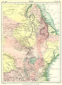
NILE VALLEY. Sudan Tanzania Ethiopia Uganda Lake Victoria. Britannica. 1898 mapJasper524.5(9.9k)See Sold PriceFeb 28, 2024
Algeria Morocco & Tunis. North Africa. Tunisia. Maghreb. BARTHOLOMEW 1898 mapJasper524.5(9.9k)See Sold PriceFeb 28, 2024
COLONIAL CENTRAL AFRICA. Congo German East Africa Rhodesia. BARTHOLOMEW 1898 mapJasper524.5(9.9k)See Sold PriceFeb 28, 2024
AFRICA French Congo State Soudan Nile Delta Suez canal by GW BACON 1898 mapJasper524.5(9.9k)See Sold PriceFeb 28, 2024
Churchill & Nieuhof 1744 Map. Batavia Jakarta IndonesiaAlbion Auctions4.7(341)See Sold PriceMar 01, 2024