ATLAS of ANTIENT GEOGRAPHY by SAMUEL BUTLER 1843John McInnis Auctioneers,LLC4.6(502)See Sold PriceFeb 24, 2024
18TH C. ANTIQUE MAP: FRENCH & INDIAN WAR, FRAMEDThomaston Place Auction Galleries4.4(386)See Sold PriceFeb 24, 2024
Rand McNally Railroad Map Cabinet w/ 21 Railroad MapsRail & Road Auctions4.6(165)See Sold PriceMar 08, 2024
Keith Haring - Ink on New York Map, Best Buddies, Inscribed, Signed, and DatedSapphire Auction Gallery4(67)See Sold PriceMar 02, 2024
LATE 17TH C. FRENCH MAP OF THE NEW WORLD BY ALEXIS-HUBERT JAILLOT (1632-1712)Thomaston Place Auction Galleries4.4(386)See Sold PriceFeb 24, 2024
Central Railroad of New Jersey Map of Sandy Hook Route-ca. 1903JM Hobby Supply and Railroad Artifact Auctions4.4(126)See Sold PriceFeb 24, 2024
Lot of Six Mixed Atlas Box Cars-HO Scale-New in BoxJM Hobby Supply and Railroad Artifact Auctions4.4(126)See Sold PriceFeb 25, 2024
Rand McNally/Santa Fe Railroad Map of Iowa-1912JM Hobby Supply and Railroad Artifact Auctions4.4(126)See Sold PriceFeb 24, 2024
NICOLAES VISSCHER (NETHERLANDS, 1618-1709) MAP OF THE NEW WORLDThomaston Place Auction Galleries4.4(386)See Sold PriceFeb 24, 2024
17TH C. WORLD MAP BY NICOLAES VISSCHER (NETHERLANDS, 1618-1709)Thomaston Place Auction Galleries4.4(386)See Sold PriceFeb 24, 2024
Lot of Six Mixed Atlas Cabooses-HO Scale-New in BoxJM Hobby Supply and Railroad Artifact Auctions4.4(126)See Sold PriceFeb 25, 2024
Sold(4) ANTIQUE FRENCH MAPS - FROM CHRISTIE'S AUCTIONFour antique French maps of Africa & Middle East. They were purchased from Christie's auction in 1994. Measures 8.75" x 7.75" to 16.25" x 13.5" w/ frames.See Sold Price
Thomson: Antique Map of Europe in 4 Sheets, 1817A map of Europe, with the political divisions after the Peace of Paris and Congress of Vienna [4 sheets]' This very large map, printed on 4 sheets, shows a re-aligned Europe after the Congress of VienSee Sold Price
Part of the United States of North America, 1798Map: Part of the United States of North America Cartographer: J. Stockdale Publishing: London, 1798 Size: 18.4 x 16.2 inches This antique map of the recently formed United States is filled informationSee Sold Price
Soldd'Anville / Santini: Antique Map of Great Lakes, 1775Map: Partie Occidentale du Canada et Septentrionale de la Louisiane Cartographer: d'Anville / Santini Place & Date: Venice / 1775 Size: 22 1/4" x 19" Condition: outline color; light overall age toningSee Sold Price
SoldMoll / Oldmixon: Antique Map of North America, 1721Map: Nieuwe Kaart van Noord Amerika Cartographer: H. Moll / Oldmixon Place & Date: Amsterdam / 1721 Size: 9 3/4" x 6 3/4" Condition: outline color; overall age toning and minor spotting In this DutchSee Sold Price
SoldColton: Antique Map of Boston, 1861Title/Content of Map: Boston by Colton Date Printed: 1861 Cartographer: J.H. Colton Material/Medium: Paper Size: 14" x 17 1/4" Hand colored, steel engraved. From Colton's 'General Atlas'. Published inSee Sold Price
SoldElwe: Antique Map of Gulf of Mexico & Caribbean, 1792Map: De Golf van Mexico, de Eilanden en het omleggende Land Cartographer: J. B. Elwe Place & Date: Amsterdam / 1792 Size: 22 3/4" x 19" Condition: Wash and outline color; light overall age toning, minSee Sold Price
Solddu Val: Antique Map of California as an Island, 1670Title: Nouveau Mexique. Wonderful 1670 miniature of California as an Island Map maker: Pierre Du Val, Le Monde ou la Geographie Universelle Place and Year: Paris, 1670 Dimensions: 3.9 x 4.7 in; 9.8 xSee Sold Price
SoldCary: Antique Map of the United States in 1811Map: A New Map of the United States of America Cartographer: John Cary Place & Date: London / 1811 Size: 20" x 17 3/4" Condition: original color; overall age toning and spotting The highly detailed maSee Sold Price
SoldHondius/Mercator: Antique Map of Japan & Korea, 1630Map: 1630 Hondius / Mercator Map of Japan and Korea - Iaponia Cartographer: J. Hondius / G. Mercator Year / Place: 1630 c. Amstredam Dimensions: 13.4 x 17.4 in. Condition: Sharp strike with the issuedSee Sold Price
Soldde Fer: Antique Map of the Caribbean Islands, 1705Map: Les Isles de L'Amerique Connues Sous le Nom d'Antilles Cartographer: de Fer Place & Date: Paris / 1705 Size: 13 1/8" x 8 3/4" Condition: outline color; some nicks along edges of margins The fasciSee Sold Price
Ottens: Antique Map of The New World, 1745Map: Terra Neuf Cartographer: Reiner & Joshua Ottens Place & Date: Amsterdam / 1745 Size: 21 7/8" x 18 3/4" Condition: Slight marginal browning and spotting, otherwise a fine copy in superb original cSee Sold Price
SoldOrtelius: Antique Map of North & South America, 1598Map: America sive Novus Orbis Date Printed: 1598 Cartographer: Abraham Ortelius Size: 4 x 3 Condition: Good condition. A few brown thumbprints and one repaired marginal tear at the Northwest coast ofSee Sold Price
SoldBellin: Antique Map of Gulf of Mexico & Caribbean, 1749Map: Carte Reduite du Golphe du Mexique et des Isles de l'Amerique Cartographer: Bellin Place & Date: Paris / 1749 Size: 32 1/4" x 21 1/8" Condition: outline color (cartouche uncolored); water stainsSee Sold Price
SoldTardieu: Antique Map of Florida & Georgia, 1798Map: Carte de la Floride et de la Georgie Cartographer: Chanlaire & Mentelle / Tardieu Place & Date: Paris / 1798 Size: 16 3/4" x 13" The dramatic Florida map, with Georgia and parts of the CarolinasSee Sold Price
Hooker: Antique Map of Lower & Midtown Manhattan, 1831Map: 1831 Hooker Lower and Midtown Manhattan Map -- Map of the City of New York Cartographer: W Hooker Year / Place: 1871 reissue, New York City Map Dimensions: 15.4 x 12.2 in. Condition: Very Good. CSee Sold Price
SoldDepot de la Marine: Antique Map of Gulf of Mexico, 1800Map: Carte des Côtes du Golfe du Mexique Cartographer: Collin/Besançon/Dépôt Général de la Marine/ Place & Date: Paris / 1800 (Year IX) Size: 35 5/8" x 23 3/4" Condition: b&w; a beautifully presSee Sold Price
Seutter: Antique Map Balkans, Hungary to Greece, 1740Title/Content of Map: Balkan's from Hungary to Greece Date Printed: c1740 Cartographer: Matthaus Seutter Material/Medium: Paper Size: 23 1/2" x 19 3/4" Original hand colored copperplate engraved. PublSee Sold Price
SoldJanssonius: Antique Map of Virginia to Florida, 1639Map: Virginia to Florida Date Printed: 1639 Cartographer: Janssonius Joannes Material/Medium: Paper Size: 21 1/2" x 17 1/4" Hand colored, copperplate engraved. French edition. Virgina to Carolna coastSee Sold Price
Mercator / Hondius: Antique Map of Sicily, 1589Map: Siciliae Regnum - Kingdom of Sicily Cartographer: Mercator Place & Date: Amsterdam / 1589/1609 Size: 18 3/4" x 13 1/4" Condition: original color; overall age-toning and light water-staining in ouSee Sold Price
SoldBellin: Antique Map Gulf of Mexico & West Indies, 1754Title/Content of Map: Carte du Golphe de Mexique et des Isles de l'Amerique Cartographer: Jacques Bellin Place & Date: Paris / 1754/1760 Size: 14 3/4" x 10 3/4" Condition: b&w; old folds as published;See Sold Price
SoldBellin: Antique Map of Northern Philippines, 1740Title/Content of Map: Northern Philippines Date Printed: 1740's-70's Cartographer: J.N. Bellin & J.F. La Harpe Material/Medium: Paper Size: 6" x 9 3/4" Copperplate engraved. From the 'Abrege de L'HistSee Sold Price
SoldSanson: Antique Map of the Ancient World, 1679Map: Orbis Vetus, et Orbis Veteris Utraque Continens, Terrarumque Tractus Arcticus et Antarctibus Cartographer: Nicholas Sanson Place & Date: Paris / 1679 Size: 21 1/4" x 15" Condition: outline color;See Sold Price
Soldvan den Keere / Langenes: Antique Map West Indies, 1598Title/Content of Map: Insularum Cubae, Hispaniolae, Iucatanae & circumjacentium describtio Cartographer: van den Keere / Langenes Place & Date: Amsterdam / 1598 Size: 5" x 3 1/4" Condition: b&w; overaSee Sold Price
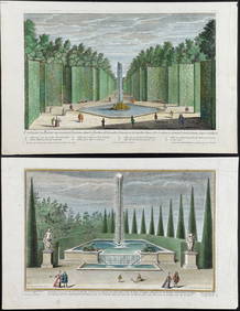
Demortain - 4 Fountain & Garden EngravingsTrillium Antique Prints & Rare Books4.5(30)See Sold PriceFeb 24, 2024
Brookshaw - 6 Cherry LithographsTrillium Antique Prints & Rare Books4.5(30)See Sold PriceFeb 24, 2024
Linnaeus - Pair: Bengal & Golden OriolesTrillium Antique Prints & Rare Books4.5(30)See Sold PriceFeb 24, 2024
Linnaeus - Passerina or Little OwlTrillium Antique Prints & Rare Books4.5(30)See Sold PriceFeb 24, 2024
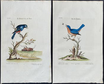
Edwards & Seligmann - 4 Bird EngravingsTrillium Antique Prints & Rare Books4.5(30)See Sold PriceFeb 24, 2024
Audubon, Imperial Folio - 4 Lithographs of Squirrel, Rat, MiceTrillium Antique Prints & Rare Books4.5(30)See Sold PriceFeb 24, 2024
WEST AFRICA Niger/Gambia rivers tribes towns. 'Pays des Negres'. MALLET 1683 mapJasper524.5(9.8k)See Sold PriceFeb 28, 2024
WEST CENTRAL AFRICA. Congo Angola Gabon Cameroon Sao Tome. MALLET 1683 old mapJasper524.5(9.8k)See Sold PriceFeb 28, 2024
NORTH AFRICA. 'Biledulgerid', a former North African country. MALLET 1683 mapJasper524.5(9.8k)See Sold PriceFeb 28, 2024
MALLET. Description de l'Univers. Africa. Volume 3 title page. MALLET 1683Jasper524.5(9.8k)See Sold PriceFeb 28, 2024
SUB-SAHARAN AFRICA. 'Ancienne Ethiopie'. Ancient Ethiopia. MALLET 1683 old mapJasper524.5(9.8k)See Sold PriceFeb 28, 2024
Goode, George Brown 1884 Lot of 4 Natural History & Meteorology MapsAlbion Auctions4.6(336)See Sold PriceMar 01, 2024
Charles Antoine Lemaire (1800 - 1871) - Set of 4 Botanical Prints - Rose - Camellia Duchesse deProverde Auctions4.3(3)See Sold PriceFeb 28, 2024
Antique Map of Poland, 1700 by Guillaume De Lisle, ParisAntiques Online Auctions4.6(407)See Sold PriceMar 14, 2024
Antique Map of France, 1703 by Gillaume Del Isle PrintAntiques Online Auctions4.6(407)See Sold PriceMar 14, 2024