SoldHandcolored Map of North America and CanadaHistoric Maps Lovely Handcolored Map of North America and Canada c. 1755 (1755-Dated) French and Indian War Era, Hand-colored, Copper-engraved, Map of North America and Canada, entitled, “Partie OriSee Sold Price
SoldHandcolored Map of North America and CanadaHistoric Maps Lovely Handcolored Map of North America and Canada c. 1755 (1755-Dated) French and Indian War Era, Hand-colored, Copper-engraved, Map of North America and Canada, entitled, “Partie OriSee Sold Price
SoldHandcolored Map of North America and CanadaHistoric Maps Lovely Handcolored Map of North America and Canada c. 1755 (1755-Dated) French and Indian War Era, Hand-colored, Copper-engraved, Map of North America and Canada, entitled, “Partie OriSee Sold Price
SoldAMERIQUE SEPTENTRIONALE, Map of North AmericaHistoric MapsAMERIQUE SEPTENTRIONALE, (North America), Choice Extremely Fine. This small map is handcolored in outline, and features North America, from Canada and Greenland down to the top of South ASee Sold Price
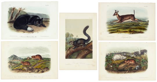
Sold[NORTH AMERICA/CANADA]. 6 hand-colored lithog[NORTH AMERICA/CANADA]. 6 hand-colored lithograph maps. Very good condition. ++ 2 published by Thomas, Cowperthwait & Co., Phila., 1850. Each about 12 1/2 x 15 5/8. (1) Canada West Formerly Upper CanaSee Sold Price
Sold1705 REGIONAL NORTH AMERICA HAND-COLORED MAP FEAT1705 REGIONAL NORTH AMERICA HAND-COLORED MAP FEATURING VIRGINIA, "Le Canada, ou Nouvelle France, la Floride, la Virginie, Pensilvanie, Caroline, Nouvelle Angleterre et Nouvelle Yorck, I'Isle de TerreSee Sold Price
SoldMap of Southeastern North America and CanadaHand-Colored, Engraved and Framed Map of Southeastern North American and Canada, including Louisiane, Mexique, Floride, The Great Lakes, and the east coast Atlantique states, titled "Etats Unis De L'ASee Sold Price
SoldMOLL, HERMAN. A Map of New France Containing Canada,MOLL, HERMAN. A Map of New France Containing Canada, Louisiana &c. in Nth America. Hand-colored engraved map of colonial North America. 7¾x10¾ inches sheet size, ample margins; mounted to foSee Sold Price
Sold19 maps, mostly 19th century[Miscellany]. 19 Maps. Includes 11 maps of portions of Europe, 5 of portions of Canada, 1 North America, 2 of Middle East. 10 hand-colored maps from various editions of Johnson's Illustrated Family AtSee Sold Price
Soldc. 1755 Handcolored Map: Great Lakes and CanadaHistoric Maps c. 1755 Handcolored Map of The Great Lakes and Canada c. 1755 (1755-Dated) French and Indian War Era, Hand-colored, Copper Plate-engraved, Map, Primarily of North America Great Lakes RegSee Sold Price
Soldc. 1755 Handcolored Map: Great Lakes and CanadaHistoric Maps c. 1755 Handcolored Map of The Great Lakes and Canada c. 1755 (1755-Dated) French and Indian War Era, Hand-colored, Copper Plate-engraved, Map, Primarily of North America Great Lakes RegSee Sold Price
Sold(CANADA.) Part of North America containing Can(CANADA.) Part of North America containing Canada, the North Parts of New England and New York. Engraved map, 210x300 mm, ample margins; hand-colored in outline; few nicks along bottom edge. Np, circaSee Sold Price
Map of North America - 1850'sMap of North America Showing Alaska as Russian Possessions and Canada as British Possessions. Hand Colored. Cartographer: George Woolworth Colton Dated: C 1850'sSee Sold Price
SoldTravels In N. America In1827-28, hand colored map, 1830Title: Travels In North America, In The Years 1827 And 1828 Provenance: IN THREE VOLUMES, 1830, with large hand colored folding map of United States and Canada showing Capt. Hall's route. [HOWES H 47]See Sold Price
SoldGEOGRAPHICAL & STATISTICAL MAP OF CANADA, 1823Hand-colored map surrounded by statistical data, 'Geographical, Statistical and Historical Map of Upper and Lower Canada, and the Other British Possessions in North America.' Sight size 17 x 21, overaSee Sold Price
SoldWELD, Isaac. Travels through the States of North AWELD, Isaac. Travels through the States of North America and the Provinces of Upper and Lower Canada.London: John Stockdale, 1799. 4to (260 x 200 mm). Engraved folding map (hand-colored in ouSee Sold Price
SoldCanadian MapA 1782 J. Bew (London) Map of the Northern United States and Canada. Hand colored engraving entitled "A New & Accurate Map of the Province of Canada in North America". Wear and even discoloration, cenSee Sold Price
Sold(Maps and Charts, North America), Seutter, Albrec(Maps and Charts, North America), Seutter, Albrecht Karl, Partie orientale de la nouvelle France ou du Canada, Augsburg: Matthaeus Seutter, [1750 or later], hand-colored, sight size 611 x 520 mm, (cenSee Sold Price
Sold(CANADA.) Sayer, Robert. A New and Correct Map(CANADA.) Sayer, Robert. A New and Correct Map of the British Colonies in North America. Double-page engraved map, 500x680 mm, wide margins; hand-colored in outline; browned along the fold, other scatSee Sold Price
SoldMONK, JACOB. New Map of that Portion of NorthMONK, JACOB. New Map of that Portion of North America exhibiting the United States and Territories [including Canada, Mexico and Central America]. Hand-colored engraved roll map, 1440x1560 mm; shellacSee Sold Price
SoldCANADA AND THE REGION MAPS, LOT FO THREE, hand-coCANADA AND THE REGION MAPS, LOT FO THREE, hand-colored "Partie Occidentale Du Canada..", M. Bonne, Paris, no date evident, "British Colonies in North America", no date evident, and "A New Map of UpperSee Sold Price
Sold(CANADA.) Baldwin and Cradock. Group of 5 engr(CANADA.) Baldwin and Cradock. Group of 5 engraved maps of Canadian subjects, hand-colored in outline, on small folio sheets; condition generally fine. London, 1832 North America. Sheet III. Upper CanSee Sold Price
Sold(TRAVEL.) Weld, Isaac. Travels through the States of(TRAVEL.) Weld, Isaac. Travels through the States of North America, and the Provinces of Upper and Lower Canada. 5 folding maps and plans (one hand-colored in outline), 11 folding plates. xix, [1], 42See Sold Price
SoldTwo Maps by A. J. Johnson, consisting of " NorthTwo Maps by A. J. Johnson, consisting of " North America," 1861, hand colored, h.- 27 in., W.- 18 1/8 in.; together with "Canada, East or Lower Canada and New Brunswick," 1863-1869, H.- 11 7/8 in., W.See Sold Price
5 Dollars - Elizabeth II Map of North AmericaWeatherham Estate Treasures3.9(157)See Sold PriceMar 07, 2024
[MAP]. [ALBRIZZI, Giambatista, 1698-1777]. Carta Geografica...Potter & Potter Auctions4.6(539)See Sold PriceMar 07, 2024
Audubon, Imperial Folio - Canada Lynx. 16Trillium Antique Prints & Rare Books4.5(30)See Sold PriceFeb 24, 2024
First 50 plates from Audubon's Quad Quarto (all in Vol. I)PBA Galleries4.7(381)See Sold PriceMar 07, 2024
Nearly complete set of plates from Vol. III Quad QuartoPBA Galleries4.7(381)See Sold PriceMar 07, 2024
Italian edition of Sanson's map of North America, 1677PBA Galleries4.7(381)See Sold PriceMar 07, 2024
Herman Moll A New Map of Ye North Parts of AmericaWillow Auction House4.5(283)See Sold PriceMar 14, 2024


![[NORTH AMERICA/CANADA]. 6 hand-colored lithog (1 of 1)](https://p1.liveauctioneers.com/179/10971/2682757_1_x.jpg?height=282&quality=70&version=1162265652)


![[MAP]. [ALBRIZZI, Giambatista, 1698-1777]. Carta Geografica... (1 of 1)](https://p1.liveauctioneers.com/928/318880/171361280_1_x.jpg?height=282&quality=70&version=1707501302)