SoldNicholas Visscher Map Black Sea Region Istanbul 1Nicolaes Visscher I (1618-1679), "Nouvelle Carte de la Mer Noire et du Canal de Constantinople tres exacte; mises au Jour," Amsterdam, 1680. A scarce hand colored engraving map bearing the imprints ofSee Sold Price
SoldAntique 18th C Imperium Turcicum Hand Colored MapAntique 18th C Imperium Turcicum Hand Colored Map. Circa 1730s. The map shows the Ottoman Empire with an area between Ukraine and Black Sea in the north, Persia / Iran in the east, Arabia and Egypt inSee Sold Price
GREAT OLD RUSSIAN MAP INCL BLACK SEA REGION 1720GREAT OLD RUSSIAN MAP INCLUDING BLACK SEA REGION 1720. Comprising a large and impressive hand colored map "TABULA GEOGRAPHICA QUA PARS RUSSIAE MAGNAE PONTUS EUXINUS SEU MARE NIGRUM ET TARTARIA MINOR��See Sold Price
Sold2 pieces. Hand-Colored Maps. Ortelius, Abraham: T2 pieces. Hand-Colored Maps. Ortelius, Abraham: Thraciae." Antwerp, 1585. 14 x 18 3/4 inches; 355 x 476 mm. * "Pontus Euxinus" [The Black Sea]. Antwerp, 1590. 14 x 19 7/8 inches; 355 x 504 mm. Both wiSee Sold Price
SoldMap of the Eastern Mediterranean and Black Sea Areas byCopper plate, hand-colored engraved map titled "Carte Genrerale Pour L'Intelligence De L'Histoire Profane Du Quatrieme Age." by Claude Buy De Mornas. Map was published for the Atlas Historique et GeogSee Sold Price
1542 PTOLEMY MAP of ARMENIA CAUCASUS BLACK SEA antiqueTabula Asiae II (Sarmatia Asiatica) By Ptolemaeus, Claudius Woodcut map. Hand colored. Verso illustrated with a decorative woodcut illustration - the woodcut border surrounding is the work of Hans HolSee Sold Price
SoldSpeed map of Russia 1676Title: A Map of Russia Author: Speed, John Description: Copper-engraved map, hand-colored. 40x51 cm. (15½x20").Map of Russia east of the Volga, including the Black Sea and Caspian Sea. With inset plaSee Sold Price
SoldHEIRS OF JOHANN BAPTIST HOMANN (GERMAN, 1663-1724) MAPHEIRS OF JOHANN BAPTIST HOMANN (GERMAN, 1663-1724) MAP OF RUSSIAN BLACK SEA REGION, hand-colored, on laid paper, title in cartouche in upper right corner "Tabulae Geographica qua pars Russiae Magnae PSee Sold Price
19th century map of Turkey, The Black Sea19th century map of Turkey, The Black Sea and the Mediterranean from Pinkerton's Modern Atlas, dated 1813. Hand-colored in outline. Fine archival matte and frame.See Sold Price
SoldJ. B. Elwe: Black Sea 1792Map: Nouvelle Carte de la Petite Tartarie. Area surrounding the Black Sea Maker: J. B. Elwe Origin: Amsterdam Date: 1792 Medium: Hand-colored engraving Sheet Size: 21.25 x 24.75 inches No Reserve: ThiSee Sold Price
SoldH. Moll, 1736, Map includes Moscovy & PolandAlso includes Little Tartary and the Black Sea. Dedicated to Peter Alexovitz, Absolute Lord of Russia. 1736. Constructed in 2 panels; hand colored. Tears to bottom at folds. Tears and losses to rightSee Sold Price
SoldFramed map Danubius Fluvius Maximus, A Fontibus AdFramed map Danubius Fluvius Maximus, A Fontibus Ad Ostia, c. 1636-1642, map maker J. Jansson, depicts the Course of the Danube River from its sources in the Alps to the Black Sea, hand colored, most lSee Sold Price
SoldArea surrounding the Black Sea.Maker: J. B Elwe. Origin: Amsterdam, 1792. Medium: Original hand-colored engraving. Sheet size: 21 1/4 x 24 3/4 in No Reserve: This lot starts at $1 and has no reserve as a courtesy so that collectorsSee Sold Price
SoldThe Coast of West Florida and Louisiana, 1794by Thomas Jefferys (1719-1771), 1794, a hand-colored map and sea chart of the southern coast from Louisiana to western Florida from Jefferys' West India Atlas, detailing the trade routes uSee Sold Price
Sold18TH C. HOMANN HAND COLORED MAP OF CASPIAN SEAThe framed map also depicting parts of Russia. 19.5" X 23" Provenance: A New Haven, CT estateSee Sold Price
SoldTwo Hand-Colored Maps and Two Black-and-White Engravings including [Terra Firma et Novum Regnum Granatense et Popayan], Blaeu's hand-colored in outline map of Granada, circa 1640, 14-3/4 x 19-1/4 in. (sight), [overall toning; matted andSee Sold Price
Sold(3) 19th c. hand colored maps of ConnecticutGrouping of three circa 1867 hand colored maps and one black and white advertisement from the "Atlas of New York and Vicinity" by Beers, Ellis & Soule, the drawings based on land surveys performed undSee Sold Price
Sold(4) 19th c. hand colored maps of ConnecticutGrouping of four circa 1867 hand colored maps and one black and white advertisement from the "Atlas of New York and Vicinity" by Beers, Ellis & Soule, the drawings based on land surveys performed undeSee Sold Price
Sold(4) Mid 19th c. hand colored maps of New YorkGrouping of four circa 1867 hand colored maps and one black and white advertisement from the "Atlas of New York and Vicinity" by Beers, Ellis & Soule, the drawings based on land surveys performed undeSee Sold Price
Sold(4) 19th c. hand colored maps of ConnecticutGrouping of four circa 1867 hand colored maps and one black and white advertisement from the "Atlas of New York and Vicinity" by Beers, Ellis & Soule, the drawings based on land surveys performed undeSee Sold Price
(4) Mid 19th c. hand colored maps of New YorkGrouping of four circa 1867 hand colored maps and one black and white advertisement from the "Atlas of New York and Vicinity" by Beers, Ellis & Soule, the drawings based on land surveys performed undeSee Sold Price
SoldFramed Italian Engraved Hand Colored Map of theFramed Italian Engraved Hand Colored Map of the Adriatic Sea, with Latin and Italian writing; focusing on three islands: San Domino, Santo Niccola, and La Caprara; written in Latin at the top "InsulaeSee Sold Price
SoldMap, Antique, EuropeanFramed hand-colored engraved map, Mittellaendisches Meer [Mediterranean Sea], 18th century, plate: 21.5''h x 30.5''w, overall: 32''h x 40''wSee Sold Price
SoldHand-colored map of Italy and the Ligorian Sea - 1Hand-colored map of Italy and the Ligorian Sea - 18th c. or earlier - 19" x 15"See Sold Price
MARTINET / DE VRIES Catechism of Nature 4 Vol. Set c1788 Engravings Rare!Luis Porretta Fine Arts4.3(10)See Sold PriceMar 02, 2024
BOTH TITLE PAGES OF COLLINS" COASTAL SURVEY, 1776, IN MATCHING FRAMESThomaston Place Auction Galleries4.4(386)See Sold PriceFeb 24, 2024
17TH C. ENGLISH LINEAR MAP BY OGILBY, FRAMEDThomaston Place Auction Galleries4.4(386)See Sold PriceFeb 24, 2024
PIETER SCHENK / VALK / JANSSEN Hand Colored Map of Rhodes Greece ca1702 vgcLuis Porretta Fine Arts4.3(10)See Sold PriceMar 02, 2024
Hand Colored Map of the city of Amsterdam 1720Global Auctions Company4.3(36)See Sold PriceMar 03, 2024
Johann Homann Hand-Colored Map Engraving, c. 1730Auctions at Showplace4.5(726)See Sold PriceMar 17, 2024
William Simpson's Sketches at the Seat of War - Two Volumes with 81 Hand-colored LithographsTrillium Antique Prints & Rare Books4.5(30)See Sold PriceFeb 24, 2024
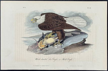
Audubon - White-headed Sea Eagle or Bald Eagle. 14Trillium Antique Prints & Rare Books4.5(30)See Sold PriceFeb 24, 2024
Catesby, Folio - Red Bellied Woodpecker & Hairy Woodpecker with Black Oak. 1-19Trillium Antique Prints & Rare Books4.5(30)See Sold PriceFeb 24, 2024
Vacheron Constantin Overseas World Time 43.5 mm Steel Mens WatchGolden Gate Auctioneer4.1(273)See Sold PriceFeb 24, 2024
Galliae Regionis Nova Descriptio Hand Colored Map of France on Laid Paper, Ca. 16th Century, H 10" WDuMouchelles4.6(825)See Sold PriceMar 15, 2024