3-sheet chart of Lonng Island Sound 1855Heading: Author: U.S. Coast Survey Title: Long Island Sound... From a Trignometrical survey under the direction of F. R. Hassler and A. D. Bache Superintendents of the Survey Of The Coast Of The UnitSee Sold Price
Sold3-sheet chart of Lonng Island Sound 1855Heading: Author: United States Coast Survey Title: Long Island Sound... From a Trignometrical survey under the direction of F. R. Hassler and A. D. Bache Superintendents of the Survey Of The Coast OfSee Sold Price
Sold3-sheet chart of Long Island Sound 1855Title: Long Island Sound. Western Sheet [in set with] Middle Part of Long Island Sound [and] Eastern Part of Long Island Sound Author: U.S. Coast Survey Description: Together, 3 sheet forming one largSee Sold Price
Sold3 Coast Chart of Long Island SoundLong Island Sound... From a Trignometrical survey under the direction of F. R. Hassler and A. D. Bache Superintendents of the Survey Of The Coast Of The United States. U.S. Coast Survey. Washington, 1See Sold Price
SoldA chart of Long Island Sound, dated 1822, publiA chart of Long Island Sound, dated 1822, published by Edmund Blunt for W. Hooker, 7 3/4'' x 17 3/4''.See Sold Price
SoldEldridge's Chart A2 or Sheet No. 2Original, early 20th century Eldridge chart showing Long Island Sound, southern Connecticut, and part of Long Island. Highlights include Great Peconic Bay, Little Peconic Bay, Shelter Island, GardinerSee Sold Price
Sea Chart Mid-Part Long Island SoundU.S. Coast Survey. 115. Middle Part of Long Island Sound from a Trigonometrical Survey... Lithographed map. U.S. Coast and Geodetic Survey, 1889. 24 ½" x 34 ½" sheet. the Connecticut coast and tSee Sold Price
Maldive Islands - Indian Ocean, 3 sheets, BritishTitle/Content of Map: Maldive Islands - Indian Ocean, 3 sheets, British Admiralty Charts 66a, 66 b and 66c, published in 1839 Date Printed: Sheet 1 Engraved: 1839 Edition: 1918 Sheet 2 Engraved: 1839See Sold Price
Maldive Islands - Indian Ocean, 3 sheets, BritishTitle/Content of Map: Maldive Islands - Indian Ocean, 3 sheets, British Admiralty Charts 66a, 66 b and 66c, published in 1839 Date: Sheet 1 Engraved: 1839 Edition: 1918 Sheet 2 Engraved: 1839 Edition:See Sold Price
Maldive Islands - Indian Ocean, 3 sheets, BritishTitle/Content of Map: Maldive Islands - Indian Ocean, 3 sheets, British Admiralty Charts 66a, 66 b and 66c, published in 1839 Date: Sheet 1 Engraved: 1839 Edition: 1918 Sheet 2 Engraved: 1839 Edition:See Sold Price
SoldCHART A NOT YET LISTED IN THE STANDARD REFERENCESGeorge W. Eldridge's Chart A. Long Island Sound from New York to New London. Lithographed map. Eldridge, c. 1895. 26 1/2" x 83 1/2" sheet. Use Eldridge's Tide Book with this chart. Huge 7 feet wide. WSee Sold Price
Long Island Sound (Western Sheet)Title/Content of Map: Long Island Sound (Western Sheet) Cartographer: U.S. COAST SURVEY/F. R. HASSLER Date: 1866 Publisher: GPO Size: 24.5Height - 35Width "Published in 1855" New York and ConnecticutSee Sold Price
Long Island Sound (Western Sheet)Title/Content of Map: Long Island Sound (Western Sheet) Date: 1866 Cartographer: U.S. COAST SURVEY/F. R. HASSLER Publisher: GPO Size: 24.5Height - 35Width Published in 1855 New York and Connecticut coSee Sold Price
Massive Long Island Sound Coast ChartHassler, Ferdinand R. (1770-1843), & U.S. Coast Survery. Eastern Part of Long Island Sound | Middle Part of Long Island Sound | Western Long Island Sound Three engraved maps. GPO, 1855. 105" wide if aSee Sold Price
Caamano Manuscript Map of Alaska[Map, Alaska, Pacific] CAAMANO, Jacinto (1759-1825). Manuscript Chart of Bucareli Sound, Alaska (Scale in Nautical Miles). Ink on paper. Spain, c. 1792. 21 1/2" x 17 3/4" sheet, 31" x 28" framed. A RASee Sold Price
Western Pacific: 2 wall maps, 1882.[Pacific]. Western Pacific. 2 Wall Maps: Charts 3 and 4. Lon: James Imray & Son, 1882. (1) Chart No. 3: ''Sheet No. 6'' in upper margin. Includes Marshall and Caroline Islands. 49 1/2 x 39 7/8 inches.See Sold Price
SoldManuscript Chart of AlaskaCAAMANO, Jacinto (1759-1825?). Manuscript Chart of Bucareli Sound, Alaska (Scale in Nautical Miles). Ink on paper. Spain, c. 1792. 21 1/2 x 17 3/4 inches sheet, 31 x 28 inches framed A RARE EIGHTEENTHSee Sold Price
1830 Geographical Charts3 Charts on one sheet back to back. 1. Exhibiting the Comparative Extent of Oceans, Continents, Countries, Islands, Seas and Lakes - 2. Height of the Principal Mountains on theSee Sold Price
Captain's Chart - Off Newport, Block IslandU.S. Coast Survey. Coast Chart No.114 Newport to Plum Island Including Block Island Sound... Lithographed map. U.S. Coast and Geodetic Survey, 1889. 28 ¾" x 41 ½" sheet. A favorite yachting andSee Sold Price
Scarce Captain's Chart of W. Long Island & NYCHassler, Ferdinand R. (1770-1843), Blunt, E., Ferguson, J. & Eakin, C. M. et al. Long Island Sound (Western Sheet)/ Continuation to New York. Lithographed map. U.S. Coast and Geodetic Survey, 1889. 24See Sold Price
Bay of Bengal - East Coast, sheet 3 Koronge Island toTitle/Content of Map: Bay of Bengal - East Coast, sheet 3 Koronge Island to White Point British Admiralty Chart 823, published in 1873 Date Printed: 1873 Cartographer: British Admiralty Material/MediuSee Sold Price
SoldDALRYMPLE, ALEXANDER. 3 double-page engraved charts ofDALRYMPLE, ALEXANDER. 3 double-page engraved charts of island chains in the East Indies. Approximately 21¾x30½ inches each sheet size, wide margins; scattered edge stains but very good in geSee Sold Price
Maldive Islands #3 South Walker/EAST INDIA COMPANY sea chart 1839 (1950) mapTitle: Maldive Islands #3 South Walker/EAST INDIA COMPANY sea chart 1839 (1950) map Description: Trigonometrical Survey of the Maldive Islands - Sheet No. 3' by Trigonometrical Survey by Commander R.See Sold Price
Sold3 maps of India. Early 19th century.[India] 3 maps. (1) Norie, John William. “A New Chart of the Indian Sea.” London, 1831. Right sheet only. Depicting the Eastern portion of India, Bay of Bengal and the Island of Ceylon. EnSee Sold Price
LATE 18TH C. VERY LARGE CHART OF NORTHEAST CANADA BY DES BARRES (1721-1824), 1780, FRAMEDThomaston Place Auction Galleries4.4(386)See Sold PriceFeb 24, 2024
CHART "LONG ISLAND SOUND FROM NEW YORK TO MONTOCK POINT ..." New York, 1830 21" x 77" sight. FramedEldred's4.7(409)See Sold PriceFeb 27, 2024
Benita Sanders Game With Shapes 1964 Signed EtchingConcept Art Gallery4.7(508)See Sold PriceMar 06, 2024
Fanch Ledan, Interior with Easter Island HeadOld Kinderhook Auction Company4.6(217)See Sold PriceMar 05, 2024
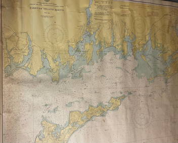
CHART: UNITED STATES - EAST COAST/ RHODE ISLAND - CONNECTICUT - NEW YORK/ Fishers IslandChurchill Galleries3.7(213)See Sold PriceFeb 26, 2024