SoldAtals of Coast Survey Charts on thick paper c.1881Heading: Author: United States Coast Survey Title: Charts of the Coast Survey (cover title) Place Published: Washington Publisher: Date Published: c.1881 Description: CompiSee Sold Price
SoldWest Coast surveys on thick paperHeading: Author: United States Coast Survey Title: Reconnaissance of the Western Coast of the United States - 3 sheets Place Published: Washington Publisher: Date Published: 1853-1869See Sold Price
SoldA.D. Bache U.S. Coast Survey Charts East CoastA.D. Bache: Preliminary Coastal Chart N. 8, Sequin Island to Kennebunkport, Maine 1859. Measures 38” X 22”. Paper size 40" x 24 1/2". Used Condition, creases, burn. electrotype have some sSee Sold Price
SoldA.D. Bache U.S. Coast Survey Charts East CoastA.D. Bache: Sketch A, Shewing The Primary Triangulation in Section 1, From 1844-1859. Scale 600,000. 1859, Measures 35.5”high X 22.5”wide. Paper size 34 3/4" x 31 1/2". Used Condition, creSee Sold Price
A.D. Bache U.S. Coast Survey Charts East CoastA.D. Bache: Sketch A, Shewing The Primary Triangulation in Section 1, From 1844-1859. Scale 600,000. 1861. Measures 30” X 26”. Paper size 33 " x 34". Used Condition, creases, burn. electroSee Sold Price
A.D. Bache U.S. Coast Survey Charts East CoastA.D. Bache: Sketch A, Shewing The Primary Triangulation in Section 1, From 1844-1859. Scale 600,000. 1859, Measures 35.5”high X 22.5”wide. Paper size 34 3/4" x 31 1/2". Used Condition, creSee Sold Price
A.D. Bache U.S. Coast Survey Charts East Coast“A bis” A.D. Bache: Sketch A, Showing the progress of the Survey in SECTION No. 1, From 1844 to 1859. Scale 400,000. 1859. Measures 38” high X 25” wide. Paper size 37 3/4" x 25See Sold Price
SoldA.D. Bache U.S. Coast Survey Charts East Coast“A bis” A.D. Bache: Sketch A, Showing the progress of the Survey in SECTION No. 1, From 1844 to 1859. Scale 400,000. 1859. Measures 38” high X 25” wide. Paper size 37 3/4" x 25See Sold Price
SoldA.D. Bache U.S. Coast Survey Charts East CoastA.D. Bache: Sketch A, Shewing The Primary Triangulation in Section 1, From 1844-1859. Scale 600,000. 1861. Measures 30” X 26”. Paper size 33 " x 34". Used Condition, creases, burn. electroSee Sold Price
SoldCoast Survey chart of San Diego 1859Heading: Author: United States Coast Survey Title: San Diego Bay California Place Published: Washington Publisher: Date Published: 1859 Description: Engraved chart. 69.5x52See Sold Price
Rare Captain's Chart of New York HarborTittman, O. H. New York Bay and Harbor. Lithographed map. U.S. Coast and Geodetic Survey, 1906. 33" x 26 ⅜" sheet. Rare captain's chart on heavy chart paper rolled, as usual for shipboard use. ESee Sold Price
SoldCoast survey reports, 1848-1850, with chartsHeading: Author: U.S. Coast Survey Title: Letter from the Secretary of the Treasury, Transmitting the report of the Superintendent of the Coast Survey...1848, 1849 [and] 1850. Place Published: WashinSee Sold Price
North America – East Coast, Bay of FundyBritishTitle: North America – East Coast, Bay of FundyBritish Admiralty Chart 352, published 1865 Date: 1865 Cartographer: British Admiralty Materials: thick paper Size: standard 71x104 cm (28x41 in) AdditSee Sold Price
New York, United States – East Coast, Approaches to NewTitle: New York, United States – East Coast, Approaches to New YorkBritish Admiralty Chart 2491, published in 1877 Date: 1877 Cartographer: British Admiralty Materials: thick paper Size: standard 71See Sold Price
United States East Coast – Block Island, Nantucket,Title: United States East Coast – Block Island, Nantucket, Rhode IslandBritish Admiralty Chart 2492, published 1887 Date: 1887 Cartographer: British Admiralty Materials: thick paper Size: standard 7See Sold Price
SoldU S Coast Survey 1896 Base Map of The United States"Isogonic Chart of the United States for the Epoch January 1900" Large Lithograph Map Published 1896, Washington for "U.S. Coast and Geodetic Survey" Folds as issued. Rare. Paper Size: 30.5 x 23.5 incSee Sold Price
[Five US Coastal Survey Maps of Charleston and SC[Five US Coastal Survey Maps of Charleston and South Carolina], including "Preliminary Chart of Charleston and Its Approaches", 1858, on thick paper (and another on thin paper); "Preliminary Chart No.See Sold Price
U S Coast Survey 1896 Base Map of The United States"Isogonic Chart of the United States for the Epoch January 1900" Large Lithograph Map Published 1896, Washington for "U.S. Coast and Geodetic Survey" Folds as issued. Rare. Paper Size: 30.5 x 23.5 incSee Sold Price
SoldMid 19th C. Framed "Coast Chart # 10"Mid 19th Century framed "Coast Chart #10" Cape Cod Bay by the US Coast Survey, 34 1/2 x 43. Fair condition, staining and paper loss.See Sold Price
U S Coast Survey 1896 Base Map of The United States"Isogonic Chart of the United States for the Epoch January 1900" Large Lithograph Map Published 1896, Washington for "U.S. Coast and Geodetic Survey" Folds as issued. Rare. Paper Size: 30.5 x 23.5 incSee Sold Price
Sold3 Coast Chart of Long Island SoundLong Island Sound... From a Trignometrical survey under the direction of F. R. Hassler and A. D. Bache Superintendents of the Survey Of The Coast Of The United States. U.S. Coast Survey. Washington, 1See Sold Price
U S Coast Survey 1896 Base Map of The United States"Isogonic Chart of the United States for the Epoch January 1900" Large Lithograph Map Published 1896, Washington for "U.S. Coast and Geodetic Survey" Folds as issued. Rare. Paper Size: 30.5 x 23.5 incSee Sold Price
SoldBOSTON HARBOR, LITHOGRAPH, C.1857Title: New Chart of Boston Harbor from U.S. Coast Survey, Pub: S. Thaxter & Son, Date: C.1857, Medium: Lithograph, Paper size: 12 x 14, Inscribed: Publisher identified in upper margin, Condition: FairSee Sold Price
SoldWest-Indies – Bahama’s, Turks Island, British AdmiraltyDetailed, unused and early chart of the coast of Turks Island. The first surveys are from 1830 by Captain R. Owen. With tidal information. Authentic, very detailed sea chart, no modern copy. On thickSee Sold Price
Southern Pacific RR Four Gateways to the Pacific Coast Brochure-1917JM Hobby Supply and Railroad Artifact Auctions4.4(126)See Sold PriceFeb 24, 2024
THE BOOK OF KELLS 3 x Limited Edition Serigraph Hand Made Prints Celtic ArtLuis Porretta Fine Arts4.3(10)See Sold PriceMar 02, 2024
THE BOOK OF KELLS 3 x Limited Edition 30 Color Serigraph Prints Celtic ArtLuis Porretta Fine Arts4.3(10)See Sold PriceMar 02, 2024
CHART "SOUTHERN COAST OF LONG ISLAND FROM MONTAUK POINT TO EAST HAMPTON" Circa 1877 11.25" x 22.75"Eldred's4.7(409)See Sold PriceFeb 27, 2024
6 Vintage Hand Drawn Mixed Media Floor PlansThe Benefit Shop Foundation Inc.4.3(2.9k)See Sold PriceFeb 28, 2024
Albrecht Durer. The Holy Family with Three Hares (c.1498). Woodcut. Hollstein 212. Meder 212, i/i.Tremont Auctions4.6(293)See Sold PriceFeb 25, 2024
Solitudo Sive Vitae Patrum Eremicolarum. Picart. 28 engraved depictions of hermits after the seriesTremont Auctions4.6(293)See Sold PriceFeb 25, 2024
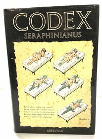
Codex Seraphinianus Illustr 1st American Edit 1983The Benefit Shop Foundation Inc.4.3(2.9k)See Sold PriceFeb 28, 2024
Alice Baber (1928-1982), "Buried Treasure of the Jaguar," 1978, Watercolor on thick wove paper,John Moran Auctioneers, Inc.4.7(453)See Sold PriceFeb 27, 2024
Stanton MacDonald-Wright, (1890-1973), Untitled, 1964, Mixed media on thick Japanese paper,John Moran Auctioneers, Inc.4.7(453)See Sold PriceFeb 27, 2024
PATRICIA BUCKLEY MOSS (1933) LIMITED EDITION ETCHING, DOUBLE HAND SIGNED AND NUMBERED, TITLED STONEThe Rug Life4.3(12)See Sold PriceMar 07, 2024
PATRICIA BUCKLEY MOSS (1933) LIMITED EDITION LITHOGRAPH, HAND SIGNED AND NUMBERED, TITLED MEMORIESThe Rug Life4.3(12)See Sold PriceMar 07, 2024
1852 CHART SHOWING POSITIONS of DAVIS'S SOUTH SHOAL & OTHER DANGERS antiqueJasper524.5(9.8k)See Sold PriceFeb 27, 2024
DALI. Biblia Sacra vulgatae editionis. 5 vols. with 105 Lithographs.TheRedFinch Auctions4.4(24)See Sold PriceFeb 29, 2024
LÁSZLÓ MOHOLY-NAGY (1895-1946) [DER STURM / EXHIBITIONS]. Group of 4 postcards. 1924-1925.Swann Auction Galleries4.4(65)See Sold PriceFeb 29, 2024
West Indies. South Coast of Jamaica from Port Royal to Pedro Bluff.Jasper524.5(9.8k)See Sold PriceFeb 27, 2024
West Indies Windward Lesser Antilles. Martinique (Belonging to France)Jasper524.5(9.8k)See Sold PriceFeb 27, 2024
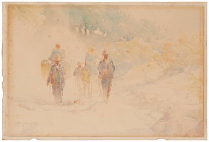
Carl Oscar Borg (1879-1947), "Les Fils du Desert," Watercolor on thick paper, Sheet: 9.75" H x 14.5"John Moran Auctioneers, Inc.4.7(453)See Sold PriceMar 12, 2024


![LÁSZLÓ MOHOLY-NAGY (1895-1946) [DER STURM / EXHIBITIONS]. Group of 4 postcards. 1924-1925. (1 of 1)](https://p1.liveauctioneers.com/199/319703/171640696_1_x.jpg?height=282&quality=70&version=1707943705)