ATLAS of ANTIENT GEOGRAPHY by SAMUEL BUTLER 1843John McInnis Auctioneers,LLC4.5(505)See Sold PriceFeb 24, 2024
18TH C. ANTIQUE MAP: FRENCH & INDIAN WAR, FRAMEDThomaston Place Auction Galleries4.4(393)See Sold PriceFeb 24, 2024
Rand McNally Railroad Map Cabinet w/ 21 Railroad MapsRail & Road Auctions4.6(165)See Sold PriceMar 08, 2024
Keith Haring - Ink on New York Map, Best Buddies, Inscribed, Signed, and DatedSapphire Auction Gallery4(67)See Sold PriceMar 02, 2024
LATE 17TH C. FRENCH MAP OF THE NEW WORLD BY ALEXIS-HUBERT JAILLOT (1632-1712)Thomaston Place Auction Galleries4.4(393)See Sold PriceFeb 24, 2024
Central Railroad of New Jersey Map of Sandy Hook Route-ca. 1903JM Hobby Supply and Railroad Artifact Auctions4.4(127)See Sold PriceFeb 24, 2024
Lot of Six Mixed Atlas Box Cars-HO Scale-New in BoxJM Hobby Supply and Railroad Artifact Auctions4.4(127)See Sold PriceFeb 25, 2024
Rand McNally/Santa Fe Railroad Map of Iowa-1912JM Hobby Supply and Railroad Artifact Auctions4.4(127)See Sold PriceFeb 24, 2024
NICOLAES VISSCHER (NETHERLANDS, 1618-1709) MAP OF THE NEW WORLDThomaston Place Auction Galleries4.4(393)See Sold PriceFeb 24, 2024
17TH C. WORLD MAP BY NICOLAES VISSCHER (NETHERLANDS, 1618-1709)Thomaston Place Auction Galleries4.4(393)See Sold PriceFeb 24, 2024
Lot of Six Mixed Atlas Cabooses-HO Scale-New in BoxJM Hobby Supply and Railroad Artifact Auctions4.4(127)See Sold PriceFeb 25, 2024
Map of Massachusetts, Martha's Vineyard & NantucketOriginal copper engraving by Matthew Carey, 1814. Map is from the 1st atlas in America offering color. Dimensions: 15" x 20 1/2" Shipping Domestic: Shipping rates are determined by destination. InternSee Sold Price
Map of Massachusetts, Martha's Vineyard & NantucketOriginal copper engraving by Matthew Carey, 1814. Map is from the 1st atlas in America offering color. Dimensions: 15" x 20 1/2" This item ships from Ocean View, DE.See Sold Price
Map of Massachusetts, Martha's Vineyard & NantucketOriginal copper engraving by Matthew Carey, 1814. Map is from the 1st atlas in America offering color. Dimensions: 15" x 20 1/2" No Reserve This item ships from Ocean View, DESee Sold Price
Map of Massachusetts, Martha's Vineyard & NantucketOriginal copper engraving by Matthew Carey, 1814. Map is from the 1st atlas in America offering color. Dimensions: 15" x 20 1/2" This item ships from Ocean View, DE.See Sold Price
Map of Massachusetts Martha's Vineyard & Nantucket 1814Original copper engraving by Matthew Carey, 1814. Map is from the 1st atlas in America offering color. Dimensions: 15" x 20 1/2" No ReserveSee Sold Price
Sold(10) Topographical Maps, S.E. Mass., 1905-1910Ten (10) topographical maps of Southeastern Massachusetts (New Bedford, Martha's Vineyard, Nantucket, Cape Cod, etc.), all 1905-1910, (9) 20" x 16 1/2", (1) 40" x 16 1/2". Some toning, some edge damagSee Sold Price
Sold1835 Bradford Map of Massachusetts1835 Bradford map of Massachusetts. Covers the entire state as well as parts of the neighboring states of Connecticut, Vermont and New Hampshire. Martha's Vineyard (Dukes Island) and Nantucket IslandSee Sold Price
Antique US Coastal Survey of Martha's Vineyard, 1856Title/Content of Map: 1856 US Coastal Survey of Martha's Vineyard amd Nantucket Area in Massachusetts -- Preliminary Chart of Part of the Sea Coast of Massachusetts from Saughkonnet River to PlymouthSee Sold Price
Antique US Coastal Survey of Martha's Vineyard 1856Title/Content of Map: 1856 US Coastal Survey of Martha's Vineyard amd Nantucket Area in Massachusetts -- Preliminary Chart of Part of the Sea Coast of Massachusetts from Saughkonnet River to PlymouthSee Sold Price
Antique US Coastal Survey of Martha's Vineyard, 1856Title/Content of Map: 1856 US Coastal Survey of Martha's Vineyard amd Nantucket Area in Massachusetts -- Preliminary Chart of Part of the Sea Coast of Massachusetts from Saughkonnet River to PlymouthSee Sold Price
SoldAntique 1856 US Coastal Survey of Martha's VineyardTitle/Content of Map: 1856 US Coastal Survey of Martha's Vineyard amd Nantucket Area in Massachusetts -- Preliminary Chart of Part of the Sea Coast of Massachusetts from Saughkonnet River to PlymouthSee Sold Price
SoldPAIR OF VINTAGE MAPS OF NANTUCKET AND MARTHA'S VINEYARDPAIR OF VINTAGE MAPS OF NANTUCKET AND MARTHA'S VINEYARD BY JACK ATHERTON Massachusetts, Circa 1937 Both depict an island and its various attractions and destinations. Published by LeBaron-Bonney Co.,See Sold Price
SoldChart of Martha's Vineyard 1881Heading: (Massachusetts - Martha's Vineyard & Nantucket) Author: Eldridge, George Title: Chart of the Vineyard Sound and Nantucket Shoals, Surveyed by George Eldridge, Hydrographer Place Published: BoSee Sold Price
Chart of Martha's Vineyard 1881Heading: (Massachusetts - Martha's Vineyard & Nantucket) Author: Eldridge, George Title: Chart of the Vineyard Sound and Nantucket Shoals, Surveyed by George Eldridge, Hydrographer Place Published: BoSee Sold Price
Martha's Vineyard Map Massachusetts Tisbury EdgarMartha's Vineyard / Dukes County, Massachusetts.'' Published by B. Ashburton Tripp: Alexandria, Virginia. First edition. Map features the Island of Martha's Vineyard in center; details include towns,See Sold Price
Martha's Vineyard Map Massachusetts Tisbury Edgartown''Martha's Vineyard / Dukes County, Massachusetts.'' Published by B. Ashburton Tripp: Alexandria, Virginia. First edition. Map features the Island of Martha's Vineyard in center; details include townsSee Sold Price
SoldCopy of 1907 Eldridge Chart of Mass. CoastCopy of a 1907 George Eldridge chart of the Massachusetts coast including Martha's Vineyard and Nantucket Island. Nicely framed. On sight 27" high x 47" long. Overall 36" high x 56" long. Good conditiSee Sold Price
SoldCopy of 1907 Eldridge Chart of Mass. CoastCopy of a 1907 George Eldridge chart of the Massachusetts coast including Martha's Vineyard and Nantucket Island. Nicely framed. On sight 27" high x 47" long. Overall 36" high x 56" long. Good conditiSee Sold Price
Copy of 1907 Eldridge Chart of Mass. CoastCopy of a 1907 George Eldridge chart of the Massachusetts coast including Martha's Vineyard and Nantucket Island. Nicely framed. On sight 27" high x 47" long. Overall 36" high x 56" long. Good conditiSee Sold Price
Barnstable Nantucket County MapBarnstable Nantucket County Map, depicting Nantucket, Martha's Vineyard and Cape Cod, matted and framed 16.5 in. x 24.5 in. Framed 24 in. x 31 in.See Sold Price
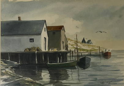
American School Maritime Painting(20th century)The Five Master Georgia Brown out of Edgartown - Martha's Vineyard Island - Nantucket Sound - Massachusetts 1887, unsigned, oil on panel, 25-1/4 x 63-3/4 in. with modern frameÿ, ProvenaSee Sold Price
Sold[Crevecoeur (Michel Guillaume St Jean de)], "J.Hec[Crevecoeur (Michel Guillaume St Jean de)], "J.Hector St.John".first edition, half-title, folding engraved maps of Nantucket and Martha's Vineyard, advertisement leaf at end, wormhole to lowerSee Sold Price
Sold(MASSACHUSETTS.) Oak Bluffs, Vineyard Highlands,(MASSACHUSETTS.) Oak Bluffs, Vineyard Highlands, Katama, Cottage City, Martha's Vineyard; Nantucket. Letterpress poster, 29 x 42 inches, printed in blue and red; minimal foxing and wear, laid down onSee Sold Price
Massachusetts & Boston, 1892Original engraving of Massachusetts with Boston inset published by Rand McNally, 1892. Also features Block Island, Cape Cod, Martha's Vineyard, Nantucket, and Rhode Island. Unframed. Light toning. DimSee Sold Price
Eliot Batchelder (MA,1901-2003) watercolor paintingBroward Auction Gallery4.7(292)See Sold PriceMar 17, 2024
Golden Plover Pair by Joseph W. Lincoln (1859-1938)Copley Fine Art Auctions4.5(40)See Sold PriceFeb 24, 2024
MARTHA FORSYTH Botanical "Gladioli" Beautiful Signed Collagraph 17" x 24" Print Listed ArtistLuis Porretta Fine Arts4.3(10)See Sold PriceMar 02, 2024
LARGE WHALEBONE SEAM RUBBER 19th Century Length 6". Blade width 2.75".Eldred's4.7(419)See Sold PriceFeb 28, 2024
Large lot of assorted prints. 18th-20th century. To include: North American and other maps, CivilTremont Auctions4.5(297)See Sold PriceFeb 25, 2024
1853 Colton's Railroad & Township Map of Massachusetts, Rhode Island, and ConnecticutRail & Road Auctions4.6(165)See Sold PriceMar 07, 2024
1849 THE NEW-ENGLAND MERCANTILE UNIONNorth American Artifact Auctions4.7(198)See Sold PriceApr 20, 2024
MARTHA FARHAM CAHOON (Massachusetts, 1905-1999), "Narcissus and Echo"., Pencil sketch on paper,Eldred's4.7(419)See Sold PriceMar 13, 2024
MINNA GRUMBT WEBB (Massachusetts/Germany, 1885-1969), Coastal shacks., Oil on canvas, 12" x 18".Eldred's4.7(419)See Sold PriceMar 13, 2024
SUSAN BRISKMAN (Massachusetts, 20th Century), Dock scene, probably Nantucket, Massachusetts., Oil onEldred's4.7(419)See Sold PriceMar 13, 2024
HELEN SHARP POTTER (Massachusetts, Contemporary), "Deep Woods"., Oil on canvas, 12" x 16". FramedEldred's4.7(419)See Sold PriceMar 13, 2024
RUTH HAVILAND SUTTON (Massachusetts, 1898-1960), "The Oldest House Nantucket"., Etching, 5" x 6.5"Eldred's4.7(419)See Sold PriceMar 07, 2024
Colorful Illustrated Map - 1938 Southern California TourismProverde Auctions4.3(3)See Sold PriceFeb 28, 2024


![[Crevecoeur (Michel Guillaume St Jean de)], "J.Hec (1 of 1)](https://p1.liveauctioneers.com/410/23994/8601736_1_x.jpg?height=282&quality=70)