ATLAS of ANTIENT GEOGRAPHY by SAMUEL BUTLER 1843John McInnis Auctioneers,LLC4.6(502)See Sold PriceFeb 24, 2024
18TH C. ANTIQUE MAP: FRENCH & INDIAN WAR, FRAMEDThomaston Place Auction Galleries4.4(386)See Sold PriceFeb 24, 2024
Rand McNally Railroad Map Cabinet w/ 21 Railroad MapsRail & Road Auctions4.6(165)See Sold PriceMar 08, 2024
Keith Haring - Ink on New York Map, Best Buddies, Inscribed, Signed, and DatedSapphire Auction Gallery4(67)See Sold PriceMar 02, 2024
LATE 17TH C. FRENCH MAP OF THE NEW WORLD BY ALEXIS-HUBERT JAILLOT (1632-1712)Thomaston Place Auction Galleries4.4(386)See Sold PriceFeb 24, 2024
Central Railroad of New Jersey Map of Sandy Hook Route-ca. 1903JM Hobby Supply and Railroad Artifact Auctions4.4(126)See Sold PriceFeb 24, 2024
Lot of Six Mixed Atlas Box Cars-HO Scale-New in BoxJM Hobby Supply and Railroad Artifact Auctions4.4(126)See Sold PriceFeb 25, 2024
Rand McNally/Santa Fe Railroad Map of Iowa-1912JM Hobby Supply and Railroad Artifact Auctions4.4(126)See Sold PriceFeb 24, 2024
NICOLAES VISSCHER (NETHERLANDS, 1618-1709) MAP OF THE NEW WORLDThomaston Place Auction Galleries4.4(386)See Sold PriceFeb 24, 2024
17TH C. WORLD MAP BY NICOLAES VISSCHER (NETHERLANDS, 1618-1709)Thomaston Place Auction Galleries4.4(386)See Sold PriceFeb 24, 2024
Lot of Six Mixed Atlas Cabooses-HO Scale-New in BoxJM Hobby Supply and Railroad Artifact Auctions4.4(126)See Sold PriceFeb 25, 2024
SoldUpdated Edition of Lewis Evan's Engraved Map of theA General Map. of the Middle British Colonies... and since corrected and improved . . . By T. Pownall. Lewis Evans (c. 1700-1756). Engraved map with original color in outline. London: R. Sayer & J. BeSee Sold Price
SoldThe General Map of the Middle British Colonies...The General Map of the Middle British Colonies, In America...Lewis Evans (1700-c.1756) & John Gibson (1750-1792). London:Jeffreys, 1758. Engraved map with original hand color in outline. 20 x 27 incheSee Sold Price
SoldEvans, Lewis A General Map of the Middle British Colonies in AmericaEvans, Lewis A General Map of the Middle British Colonies in America viz. Virginia, Maryland, Delaware, Pensilvania, New-Jersey, New York, Connecticut and Rhode Island: of Aquanishuonigy the Country oSee Sold Price
SoldA General Map of the Middle British Colonies, A General Map of the Middle British Colonies, viz. Virginia, Maryland, Delaware, Pensilvania, New Jersey, New York, Connecticut & Rhode-Island of Aquanishuonigy the Country of the Confederate IndianSee Sold Price
SoldLewis Evans and Thomas Jeffreys hand colored outlinedLewis Evans and Thomas Jeffreys hand colored outlined double page engraved map A General Map of the Middle British Colonies in America marked lower left: Sold by R. Sayer in Fleet Street and T. JefSee Sold Price
Sold1766 British Colonies MapHigh Quality Color Printed Map on heavy paper circa 1970's A General Map of the Middle British Colonies, in America. containing Virginia, Maryland, the Delaware Counties, Pennsylvania and New Jersey.See Sold Price
SoldEvans, Lewis (ca. 1900-1756). 'A General Map of TheEvans, Lewis (ca. 1900-1756). 'A General Map of The Middle British Colonies...', Printed in London, 1771, Engraved and hand colored, Thomas Jeffery's edition. Framed dimensions: h: 27 x w: 20 7/8 in.See Sold Price
SoldLewis Evans published by Robert Sayer and John BenA General Map of the Middle British Colonies in America Copperplate engraving, London, 1776 Reference: Page 165, Plate 98 in Schwartzês The Mapping of AmericaSee Sold Price
SoldEvans - Map of the Middle British ColoniesLewis Evans (circa 1700-1756), A General Map of The Middle British Colonies, in America; Viz Virginia, Màriland, Dèlaware, Pensilvania, New-Jersey, New-York, Connecticut, And Rhode Island, 1755, JaSee Sold Price
SoldLewis Evans and Thomas Jefferys, A general Map of theEVANS, Lewis (ca 1700-1756) - JEFFERYS, Thomas (1719-1771). A general Map of the Middle British Colonies in America: via Virginia, Maryland, Delaware, Pensilvania, New Jersey, New York, Connecticut anSee Sold Price
Sold1771, MAP of the MIDDLE BRITISH COLONIES IN AMERICHistoric Maps1771 "A General MAP of the MIDDLE BRITISH COLONIES IN AMERICA..." After the Original Publish'd at Philadelphia by Mr. Lewis Evans January 1, 1771-Dated, Hand-Colored Outline Map eSee Sold Price
SoldEvans - Map of the Middle British ColoniesLewis Evans (circa 1700-1756), A General Map of The Middle British Colonies in America Viz. Virginia, Maryland, Delaware, Pensilvania, New-Jersey, New York, Connecticut & Rhode-Island of AquanshuonigySee Sold Price
SoldEVANS, LEWIS. A General Map of the Middle BritEVANS, LEWIS. A General Map of the Middle British Colonies. Engraved folding map, 495x670 mm, ample margins; hand-colored in outline; fire browning in upper and side margins, extending a short distancSee Sold Price
Lewis Evans, Geographical, Historical, Political,EVANS, Lewis (ca 1700-1756). Geographical, Historical, Political, Philosophical and Mechanical Essays. The First, Containing an Analysis of a General Map of the Middle British Colonies in America; AndSee Sold Price
SoldEvans Map of the Middle British Colonies, 1755EVANS, Lewis (1700-1756). A General Map of the Middle British Colonies, in America; viz Virginia, Mariland, Delaware Pensilvania, New-Jersey New-York, Connecticut, and Rhode Island of Aquanishuonigy,See Sold Price
SoldBowles Map of the British ColoniesBOWLES, Carrington (1724-1793 ), After EVANS, Lewis (1700-1756). A General Map of the Middle British Colonies in America... Engraved Map with original hand color in part. London, 1771 (3rd State). 21See Sold Price
SoldEVANS, LEWIS. A General Map of the Middle BritEVANS, LEWIS. A General Map of the Middle British Colonies in America. Double-page engraved map, 500x645 mm, trimmed to or just within the neatline on the right side, other margins ample; hand-coloredSee Sold Price
SoldBritish Colonies in America MapRobert Sayer And John Bennett, and Thomas Pownall. A general map of the middle British colonies, in America. Containing Virginia, Maryland, the Delaware counties, Pennsylvania, and New Jersey. OriginaSee Sold Price
Sold(Maps and Charts, North America), Evans, Lewis (17(Maps and Charts, North America), Evans, Lewis (1700?-1756), A General Map of the Middle British Colonies in America: viz Virginia, Maryland, Delaware, Pensilvania, New Jersey, New York, Connecticut aSee Sold Price
SoldEVANS, LEWIS; and JEFFERYS, THOMAS. A GeneralEVANS, LEWIS; and JEFFERYS, THOMAS. A General Map of the Middle British Colonies in America. Double-page engraved map, 510x680 mm, wide margins; hand-colored in outline; some scattered browning and ofSee Sold Price
ROBERT SAYER - A GENERAL MAP OF THE MIDDLE BRITISHRobert Sayer - A General Map Of The Middle British Colonies, In America, 1776 - 40 X 29 3/4 In. - Giclée On Canvas - Museum Wrapped - Large Piece Of Art - This Piece Is Ready To Hang On Your WallSee Sold Price
Robert Sayer - A General Map Of The Middle BritishRobert Sayer - A General Map Of The Middle British Colonies, In America, 1776 - 40 X 29 3/4 In. - Giclée On Canvas - Museum Wrapped - Large Piece Of Art - This Piece Is Ready To Hang On Your WallSee Sold Price
ROBERT SAYER - A GENERAL MAP OF THE MIDDLE BRITISHRobert Sayer - A General Map Of The Middle British Colonies, In America, 1776 - 16 X 11 7/8 In. - This Giclée Print Is Gallery Stretched And Ready To Hang Or Lean Against A Wall, Or Display On An EasSee Sold Price
ROBERT SAYER - A GENERAL MAP OF THE MIDDLE BRITIRobert Sayer - A General Map Of The Middle British Colonies, In America, 1776 - Giclée On Canvas - 36 X 26 7/8 In.~~A giclée print falls between serigraph and lithograph in quality. Although they caSee Sold Price
General Books - Four Maps of Great Britain Designed by Matthew Paris About A.D. 1250TimeLine Auctions Ltd.4.5(183)See Sold PriceMar 08, 2024
1860 The Spectator Joseph Addison 1710 John Dryden Alexander Pope 4v FINE SETSchilb Antiquarian Rare Books4.8(421)See Sold PriceMar 31, 2024
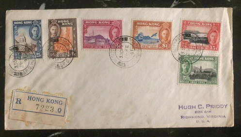
1941 Hong Kong First Day Cover FDC 100 Years British Colony Stamp Set MI 163-68Mynt Auctions4.6(680)See Sold PriceFeb 26, 2024
Arrowsmith & Lewis - Map of PolynesiaTrillium Antique Prints & Rare Books4.5(30)See Sold PriceFeb 24, 2024
Arrowsmith & Lewis - Map of North AmericaTrillium Antique Prints & Rare Books4.5(30)See Sold PriceFeb 24, 2024
Arrowsmith & Lewis - Map of the World on Mercator's ProjectionTrillium Antique Prints & Rare Books4.5(30)See Sold PriceFeb 24, 2024
Arrowsmith & Lewis - Map of LouisianaTrillium Antique Prints & Rare Books4.5(30)See Sold PriceFeb 24, 2024
Arrowsmith & Lewis - Map of the United StatesTrillium Antique Prints & Rare Books4.5(30)See Sold PriceFeb 24, 2024
Donovan's The Natural History of British Shells - 5 Volumes in 3 Books with 180 EngravingsTrillium Antique Prints & Rare Books4.5(30)See Sold PriceFeb 24, 2024
1816 MAP SOUTHERN PART OF RUSSIA or MUSCOVY in EUROPE copper engraving ANTIQUEJasper524.5(9.8k)See Sold PriceFeb 27, 2024
1816 MAP NORTHERN PART OF RUSSIA or MUSCOVY in EUROPE copper engraving ANTIQUEJasper524.5(9.8k)See Sold PriceFeb 27, 2024
Colonial Africa. British German French Spanish Portuguese Italian TIMES 1900 mapJasper524.5(9.8k)See Sold PriceFeb 28, 2024
BRITISH AFRICAN COLONIES. West Africa Ascension St. Helena Mauritius 1876 mapJasper524.5(9.8k)See Sold PriceFeb 28, 2024
AFRICA. Africa. General Map; Inset map of Population map 1907 old antiqueJasper524.5(9.8k)See Sold PriceFeb 28, 2024
Colonial Africa. British German French Spanish Portuguese Italian TIMES 1895 mapJasper524.5(9.8k)See Sold PriceFeb 28, 2024
SOUTHERN AFRICA.Inset Ascension Is.; European colonies 1914;St Helena 1920 mapJasper524.5(9.8k)See Sold PriceFeb 28, 2024
THE WHOLE CHRONICLE OF POLYBIUS ANCIENT IN ENGLISH, 1756NY Elizabeth 4.3(84)See Sold PriceMar 03, 2024