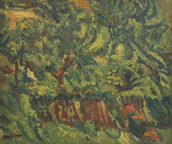
Chaim Soutine (Belarusian/French, 1893-1943) - La Petite Fille dans la VerdureFreeman's | Hindman4.5(158)See Sold PriceFeb 27, 2024
Elisabeth Frink (British, 1930-1993) - Harbinger Bird IFreeman's | Hindman4.5(158)See Sold PriceFeb 27, 2024
AMERICAN SEASCAPE PAINTING BY ROSS EMBROSE MOFFETTAntique Arena Inc.4.5(883)See Sold PriceMar 02, 2024
CHARLES HENRY GIFFORD (Massachusetts, 1839-1904), Luminist view of three sailboats in a quietEldred's4.7(423)See Sold PriceFeb 28, 2024
RARE MANHATTAN PROJECT GLASS LEADED FROM THE MANHATTAN PROJECT WORLD WAR II WW2 724 GRAMSCol. Christie Hatman Auctioneers4.4(355)See Sold PriceFeb 26, 2024
Estate Fresh Civil War Cavalry C. Roby 1863 With ScabbardRalph Fontaine Heritage Auctions Inc.4.7(236)See Sold PriceFeb 25, 2024
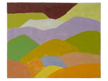
ABSTRACT ARAB LEBANESE OIL PAINTING BY ETEL ADNANAntique Arena Inc.4.5(883)See Sold PriceMar 02, 2024
SoldLarge folding map of U.S. 1873Heading: Author: Stanford, Edward Title: Stanford's Map of the United States and Part of the Dominion of Canada (title in upper margin) Place Published: London Publisher:Published by Edward StanfordSee Sold Price
Sold5 Coast Survey Reports for 1864 - 1890.[Coast Survey]. 5 Reports U.S. Coast Survey. Wash: GPO. 4to. Hardcover. (1) 1866. Covers warped. 40 large folding maps. (2) 1873. Covers separated, but present. 19 large folding maps (numbered to ''18See Sold Price
SoldLarge folding maps of U.S. & Canada 1853Heading: Author: Andrews, Israel De Wolf Title: Maps: Andrews' Report Place Published: [Washington, D.C.] Publisher:[Treasury Dept.] Date Published: 1853 Description: FourSee Sold Price
SoldLarge folding map of the U.S. & Canada 1827Title: Map of the United States; and the Provinces of Upper & Lower Canada, New Brunswick, and Nova Scotia, compiled from the latest Surveys and other authentic information Author: Walker, John & AlexSee Sold Price
SoldUSGS Mineral Resources of the US 86246Hardcover 1907 Part 1 Metallic producers. Large folding Western US map in back cover. 743pp with index. City: State: Date: 1907See Sold Price
Mineral Resources of the States and Territories WAuthor: Raymond, Rossiter W. 8 volumes. Illustrated with woodcuts, engravings, maps, etc., including several folding, large folding colored map at rear of 1873 volume. (8vo) 8¾x5¾, original brown clSee Sold Price
SoldBritish Navy in the Pacific 1873Title: Our Journal in the Pacific by the Officers of H.M.S Zealous Author: Eardley-Wilmot, S. Description: xiv, 333, [xx], [5], [24] pp. Large folding map and black and white illustrations throughoutSee Sold Price
SoldTanner. Canals & Rail Roads of the U.S.Tanner, Henry Schenck. Description of the Canals and Rail Roads of the United States. NY: T. R. Tanner & J. Disturnell, 1840. 8vo. 273p., 2 folding profiles and large folding map at rear (23.5" x 18".See Sold Price
SoldLarge folding map of Utah 1871Heading: Author: Froiseth, B.A.M. Title: Froiseth's New Sectional & Mineral Map of Utah Compiled from the latest U.S. Government Surveys and other authentic sources. Exhibiting the Sections, FractionSee Sold Price
SoldLarge folding map of Central America 1856Heading: Author: Palmer, W.R. Title: Map of Central America. Compiled from materials furnished by the Committee on Foreign Relations of the Senate of the U.S. Executed at the Office of the U.S. CoastSee Sold Price
Large folding map of Central America 1856Heading: Author: Palmer, W.R. Title: Map of Central America. Compiled from materials furnished by the Committee on Foreign Relations of the Senate of the U.S. Executed at the Office of the U.S. CoastSee Sold Price
Donaldson, Thomas. The George Catlin Indian GalleDonaldson, Thomas. The George Catlin Indian Gallery in the U.S. National Museum, Part V. Smithsonian Institution. 8vo, hard cover, vii, 939 pp. with 137 plates and large folding map. Brown cloth coverSee Sold Price
Soil Map Conn.-Mass. Springfield SheetTitle: Soil Map Conn.-Mass. Springfield Sheet Publication Date: 1903 Cartographer: FIPPIN, E. O. Publisher: U.S. DEPT. OF AGRICULTURE, BUREAU OF SOILS Brief Descriptions: Large, folding map of ConnectSee Sold Price
Soil Map Conn.-Mass. Springfield SheetTitle: Soil Map Conn.-Mass. Springfield Sheet Cartographer: FIPPIN, E. O. Publisher: U.S. DEPT. OF AGRICULTURE, BUREAU OF SOILS Size: 40.6 X 25 Large, folding map of Connecticutt River valley from SouSee Sold Price
Irrigation of San Joaquin, Tulare, & Sacramento ValleyGrant, U.S. House of Representatives. First edition. Octavo. Large folding maps. Folding plate. Scarce. Good copy. Interior fine, lacks back strip. Please note that this lot has a confidential reserveSee Sold Price
SoldReport of the Cruise of the U.S. Revenue Cutter BAuthor: Tuttle, Francis Description: [2], iv, 3-144 pp. With 48 plates from photographs; large folding color map. 9x5¾, original blue cloth, spine lettered in gilt. First Edition. Account of a cruiseSee Sold Price
SoldUS Geological Survey Vol. I 1890 Lake BonnevilleTitle: Lake Bonneville Author: Gilbert, Grove Karl Description: xx, 438 pp. Many map plates within, as well as a large loose folding map of Lake Bonneville in color, placed in rear pocket. (4to), origSee Sold Price
Sold1873 Streinger's Map of Cleveland''Stringer's 1873 Map of Cleveland and Suburb's''- drawn by Otto Dercaum, large folding hand colored map of Cleveland, Ohio with an insert on the map of the Superior Viaduct, folded as issued into gilSee Sold Price
Maps from Geo. Wheeler's Surveys 1879Title: U.S. Geographical Surveys, West of 100th Meridian. Topographical and Land Classification Atlas Sheets Author: Wheeler, [George M.] Description: 6 total large folding and loose map sheets (varioSee Sold Price
Irrigation resources of CA by Frank Adams 1913Title: Irrigation Resources of California and Their Utilization Author: Adams, Frank Description: 95 pp. 9 folding maps. 9x5½, wrappers.Large irrigation maps in this publication from the U.S. DepartmSee Sold Price
Sold1873 Hitchcock & Blake US Geological MapDESCRIPTION: Large polychrome printed Geologic Map of the United States dated 1873, produced by "C.H. Hitchcock and W.P. Blake" , lithographed by J. Bien. Produced by the United States Commission of MSee Sold Price
EAST ASIA Chinese Empire Japan China Mongolia Soongaria Tibet. COLLINS 1873 mapTITLE/CONTENT OF MAP: 'Chinese Empire & Japan' DATE PRINTED: 1873 IMAGE SIZE: Approx 23.5 x 31.0cm, 9.25 x 12.25 inches (Large); Please note that this is a folding map. TYPE: Antique colour map CONDITSee Sold Price
US MIDWEST. Missouri Illinois Indiana Iowa Chicago.TITLE/CONTENT OF MAP: 'Eastern United States No 5' DATE PRINTED: 1883 IMAGE SIZE: Approx 36.0 x 41.0cm, 14.25 x 16.25 inches (Large); Please note that this is a folding map. TYPE: Antique colour atlasSee Sold Price
EAST ASIA Chinese Empire Japan China Mongolia Soongaria Tibet. COLLINS 1873 mapTITLE/CONTENT OF MAP: 'Chinese Empire & Japan' DATE PRINTED: 1873 IMAGE SIZE: Approx 23.5 x 31.0cm, 9.25 x 12.25 inches (Large); Please note that this is a folding map. TYPE: Antique colour map CONDITSee Sold Price
1729 GERMANIA SACRA by M. Hansiz BLINDSTAMPED PIGSKIN antique FOLIO w/ MAPJasper524.5(9.9k)See Sold PriceFeb 27, 2024
1738 RUSSIA SIBERIA & GREAT TARTARY Description illustrated ANTIQUE in ENGLISHJasper524.5(9.9k)See Sold PriceFeb 27, 2024
First World War.- Petre (F.Loraine), Wilfrid Ewart & Major General Lowther. The Scots Guards in theForum Auctions4.4(54)See Sold PriceFeb 29, 2024
Birmingham.- Commercial map.- Smith (J. Pigott) To the Right Honourable William Earl of Dartmouth...Forum Auctions4.4(54)See Sold PriceFeb 29, 2024
Emory's Notes of a Military Reconnoissance larger issuePBA Galleries4.7(389)See Sold PriceMar 07, 2024
Southern Africa Cape of Good Hope-Madagascar ADMIRALTY sea chart 1935 (1955) mapJasper524.5(9.9k)See Sold PriceFeb 28, 2024
Africa. Congo Free Trade Area. British South Africa Company. STANFORD 1896 mapJasper524.5(9.9k)See Sold PriceFeb 28, 2024
Northwest Africa. Morocco Sahara Rio do Oro Ain Sefra Gardaia. STANFORD 1904 mapJasper524.5(9.9k)See Sold PriceFeb 28, 2024
Central Africa. Congo Free State Rhodesia German East Africa. STANFORD 1896 mapJasper524.5(9.9k)See Sold PriceFeb 28, 2024
Carte d'Afrique. Africa Soudan Zanzibar. LAPIE 1831 old antique map plan chartJasper524.5(9.9k)See Sold PriceFeb 28, 2024
Africa. Congo Free Trade Area. British South Africa Company. STANFORD 1894 mapJasper524.5(9.9k)See Sold PriceFeb 28, 2024
Northwest Africa. Morocco Sahara Rio do Oro Ain Sefra Gardaia. STANFORD 1904 mapJasper524.5(9.9k)See Sold PriceFeb 28, 2024


![[Tintype] Massive Bowie knife (1 of 1)](https://p1.liveauctioneers.com/7226/317626/170485482_1_x.jpg?height=282&quality=70&version=1706368022)
![[Ambrotype] Magnificent Portrait (1 of 1)](https://p1.liveauctioneers.com/7226/317626/170485477_1_x.jpg?height=282&quality=70&version=1706368022)


![[Tintype] Native American Man w/ Knife (1 of 2)](https://p1.liveauctioneers.com/7226/317626/170485453_1_x.jpg?height=282&quality=70&version=1706368022)
![[REES, Charles] Enlistedman w/ Bowie Knife (1 of 1)](https://p1.liveauctioneers.com/7226/317626/170485489_1_x.jpg?height=282&quality=70&version=1706368022)
![[Ambrotype] Wounded at Gettysburg (1 of 1)](https://p1.liveauctioneers.com/7226/317626/170485471_1_x.jpg?height=282&quality=70&version=1706368022)


![[Ambrotype] Young Soldier w/ Bowie Knife (1 of 1)](https://p1.liveauctioneers.com/7226/317626/170485459_1_x.jpg?height=282&quality=70&version=1706368022)

![[Daguerreotype] Soldier w/ Bowie Knife (1 of 2)](https://p1.liveauctioneers.com/7226/317626/170485458_1_x.jpg?height=282&quality=70&version=1706368022)
![[Tintype] Soldier w/ Flowers (1 of 1)](https://p1.liveauctioneers.com/7226/317626/170485495_1_x.jpg?height=282&quality=70&version=1706368022)
![[Tintype] Identified North Carolina Infantryman (1 of 2)](https://p1.liveauctioneers.com/7226/317626/170485474_1_x.jpg?height=282&quality=70&version=1706368022)