Vintage Ca. 1940's International Panel Delivery Truck Converted into Stationary Food Truck, WasSwisher Bros. Auction LLC4.4(255)See Sold PriceFeb 25, 2024
Martin Custom Acoustic Guitar 000 Body Style Rosewood with Hard CaseHess Fine Auctions4.5(210)See Sold PriceMar 02, 2024
1968 Gibson LG-0 Acoustic Dreadnought Parlor GuitarHess Fine Auctions4.5(210)See Sold PriceMar 02, 2024
Replica Robinson 1862 Sharps CarbineSchmidt's Antiques Inc. Since 19114.8(431)See Sold PriceMar 02, 2024
PAIR (18th c) OF FLINTLOCK DUELING PISTOLSJohn McInnis Auctioneers,LLC4.5(505)See Sold PriceFeb 24, 2024
PAIR T KETLAND of LONDON .60 CAL FLINTLOCK PISTOLSJohn McInnis Auctioneers,LLC4.5(505)See Sold PriceFeb 25, 2024
Gibson ES335 Semi Hollow Vintage Sunburst Electric Guitar with Certificate of Authenticity Hand MadeHess Fine Auctions4.5(210)See Sold PriceMar 02, 2024
WALT DISNEY WORLD - Figment Animatronic Character Skin from EPCOT's Journey Into ImaginationPropstore4.2(6)See Sold PriceMar 12, 2024
Lot Of 3 Early Large Three-Ring Binders Full Of Thousands Of StampsRbfinearts4.5(578)See Sold PriceFeb 24, 2024
A FINE PERSIAN MALAYER PRAYER RUG WITH CYPRESS C. 1860Soulis Auctions4.8(953)See Sold PriceFeb 24, 2024
Thomas Hart Benton; 20thC. American Regionalist Oil SignedMid-Hudson Auction Galleries4.4(471)See Sold PriceFeb 24, 2024
Fender USA Stratocaster Electric Guitar Classic Candy Red and White Original Stickers with Gig BagHess Fine Auctions4.5(210)See Sold PriceMar 02, 2024
1986 Fender Stratocaster Japan Blue-Green with White Pickguard and Gig Bag JapaneseHess Fine Auctions4.5(210)See Sold PriceMar 02, 2024
SoldCoast Survey report with 27 charts 1850Heading: Author: U.S. Coast Survey Title: Letter from the Secretary of the Treasury, Transmitting the report of the Superintendent of the Coast Survey, showing the progress of that work during the yeSee Sold Price
SoldCoast survey reports, 1848-1850, with chartsHeading: Author: U.S. Coast Survey Title: Letter from the Secretary of the Treasury, Transmitting the report of the Superintendent of the Coast Survey...1848, 1849 [and] 1850. Place Published: WashinSee Sold Price
SoldReport of the Superintendent of the United StatesAuthor: U.S. Coast Survey Description: xii, 334 pp. + 26 (of 27) folding charts & other plates. 11¼x8¼, cloth, spine lettered in gilt. Important volume of the Coast Survey, covering surveys the yearSee Sold Price
Sold4 early Coast Survey reports: 1844-1855.[Coast Survey] 4 early reports with charts: Alexander Bache. REPORT OF THE SUPERINTENDENT OF THE COAST SURVEY, SHOWING THE PROGRESS OF THAT WORK DURING THE YEAR ENDING NOVEMBER, 1844. Wash: 1844. 28thSee Sold Price
Coast Survey Report 1851Title: Sketches Accompanying the Annual Report of the Superintendent of the United States Coast Survey, 1851 Author: U.S. Coast Survey Description: With 58 charts and plans, most folding. 29x23.5 cm.See Sold Price
Sold7 large Coast Survey maps[Coast Survey]. 7 Maps. About 23 x 34 - 43 x 28 in., most in not all published by M.F. Maury. ++ Maury's Wind & Current Chart: No. 5, Series A. (1850). Charts the Hudson Bay region, with the St. LaureSee Sold Price
Maritime Chart, U.S. Coast Survey, San Diego To PtCHART. U.S. Coast Survey, Sketch showing the progress of the survey in Section no. X, (lower sheet), from San Diego to Pt. Sal, from 1850-1877, scale 600.000, 1877, good condition, folds, 29 1/2" T xSee Sold Price
Scarce Captain's Chart of Upper East Coast of FloridaLindenkohl, A. General Chart of the Coast No. VIII from St. Mary's Entrance to Cape Canaveral... 1882. Lithographed map. U.S. Coast and Geodetic Survey, 1882. 27 ¾" x 27 ¾" sheet.See Sold Price
Map of South and Cat Islands Winyah Bay, S.C.Title/Content of Map: Map of South and Cat Islands Winyah Bay, S.C. Date: 1931 Cartographer: WAINWRIGHT, S. A. et al Publisher: MANUSCRIPT Size: 17.3Height - 27.5Width Compiled from Coast Survey chartSee Sold Price
Map of South and Cat Islands Winyah Bay, S.C.Title/Content of Map: Map of South and Cat Islands Winyah Bay, S.C. Date: 1931 Cartographer: WAINWRIGHT, S. A. et al Publisher: MANUSCRIPT Size: 17.3Height - 27.5Width Compiled from Coast Survey chartSee Sold Price
Large Official Captain's Chart Centering On NewportU.S. Coast Survey. Coast Chart No. 113. Cuttyhunk to Block Island Including Narragansett Bay... Lithographed map. U.S. Coast and Geodetic Survey, 1890. 37 ½" x 27" sheet. Large official sea chart wSee Sold Price
U.S. Coast Survey From San Diego to Pt. Sal. 1875.EARLY CALIFORNIA CHART. U.S. Coast Survey, Sketch showing the progress of the survey in Section no. X, (lower sheet), from San Diego to Pt. Sal, from 1850-1877, scale 600.000, 1877, good condition, foSee Sold Price
General Chart of AlaskaU.S. C. & G.S., U.S. COAST AND GEODETIC SURVEY, 1895, Wall – 27.25 H x 50.25 W Inches, Two-sheet folding map at the time of the Gold Rush. Size: Wall – 27.25 H x 50.25 W Inches Please note: Item wSee Sold Price
SoldNautical Chart of HATTERAS SHOALS, CA 1850, 1/120000:Nautical Chart of HATTERAS SHOALS, CA 1850, 1/120000: US Coast Survey of the "GRAVEYARD OF THE ATLANTIC" with Sailing Instructions around Diamond Shoals/Cape Hatteras. Framed in Black Beaded Wood FramSee Sold Price
Preliminary Chart of the Pacific Coast from Point PinosTitle: Preliminary Chart of the Pacific Coast from Point Pinos to Bodega Head California Publication Date: 1865 Cartographer: BACHE, A.D. Publisher: U.S. COAST SURVEY Size: 38.8 X 27.9 Additional InfoSee Sold Price
Chart of Pacific Coast on 3 sheets 1850Heading: Author: U.S. Coast Survey A.D. Bache Superintendent Title: Reconnoissance of the Western Coast of the United States from Monterey to the Columbia River in three sheets... By the HydrographicSee Sold Price
SoldU.S. Coast Survey for 1850 in Original WrappersTitle: [Report of Professor Alexander D. Bache]. Coast Survey. Letter from the Secretary of the Treasury, Transmitting the report of the Superintendent of the Coast Survey, showing the progress of thaSee Sold Price
Report of the Superintendent of the U.S. Coast SurveyReport of the Superintendent of the U.S. Coast Survey for 1854. Washington. Beverley Tucker, Public Printer. 1855. Embossed hard-cover; the back-half of the book with fold-out maps and charts. ConditiSee Sold Price
SoldWith early Coast Survey charts of west coast 1851Heading: Author: U.S. Coast Survey Title: Sketches Accompanying the Annual Report of the Superintendent of the United States Coast Survey, 1851 (caption title) Place Published: Washington, D.C. PubliSee Sold Price
SoldU.S. Coast Survey During the Year 1853Title: Report of the Superintendent of the Coast Survey, Showing the Progress of the Survey During the Year 1853 Author: U.S. Coast Survey Description: vi, 186, [2] pp. + 54 engraved map charts and diSee Sold Price
SoldReport of the Superintendent of the United StatesAuthor: U.S. Coast Survey xxii, 419 pp. 88 maps, charts, etc. most folding. (4to) 11¼x9, original black cloth. First Edition. Several notable articles in this annual report includes: On the DeterminaSee Sold Price
SoldMaps of the United States Coast Survey, 1851Title: Sketches Accompanying the Annual Report of the Superintendent of the United States Coast Survey, 1851 Author: U.S. Coast Survey Description: With 50 (of 58) charts and plans, most folding. 29x2See Sold Price
SoldU.S Coast Survey 1853 Map. Gargathy Machipongo Inlet VA"Preliminary Chart of the Sea Coast of Virginia From Gagathy Inlet to Gr. Machipongo Inlet" Electrotype Map Published 1843-65, Washington for "Report of the Superintendent of the U.S. Coast Survey..."See Sold Price
SoldU.S Coast Survey 1853 Map. Ship Island Shoal, Louisiana"Preliminary Chart of Ship Island Shoal Louisiana" Electrotype Map Published 1843-65, Washington for "Report of the Superintendent of the U.S. Coast Survey..." Published under the supervision and direSee Sold Price
Northern RR of New Hampshire Original Bylaws-1847JM Hobby Supply and Railroad Artifact Auctions4.4(127)See Sold PriceFeb 24, 2024
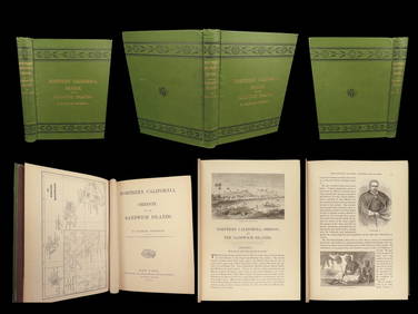
1874 HAWAII 1ed Northern California Oregon Pacific Island Travel Puget RedwoodsSchilb Antiquarian Rare Books4.8(428)See Sold PriceMar 10, 2024
LATE 18TH C. VERY LARGE CHART OF NORTHEAST CANADA BY DES BARRES (1721-1824), 1780, FRAMEDThomaston Place Auction Galleries4.4(393)See Sold PriceFeb 24, 2024
CHART "SOUTHERN COAST OF LONG ISLAND FROM MONTAUK POINT TO EAST HAMPTON" Circa 1877 11.25" x 22.75"Eldred's4.7(419)See Sold PriceFeb 27, 2024
William Trost Richards (American, 1833-1905) - Surf Hitting the CoastFreeman's | Hindman4.5(158)See Sold PriceFeb 28, 2024
Rare 27" Mystery Upside Down Chain Ball Swinging ClockCollective Hudson4.5(58)See Sold PriceMar 01, 2024
1852 CHART SHOWING POSITIONS of DAVIS'S SOUTH SHOAL & OTHER DANGERS antiqueJasper524.5(9.9k)See Sold PriceFeb 27, 2024
West Indies. South Coast of Jamaica from Port Royal to Pedro Bluff.Jasper524.5(9.9k)See Sold PriceFeb 27, 2024
MARSHALL JOHNSON, JR. (Massachusetts, 1850-1921), Fishing schooner off the coast., Watercolor onEldred's4.7(419)See Sold PriceMar 07, 2024
Southern Africa Cape of Good Hope-Madagascar ADMIRALTY sea chart 1935 (1955) mapJasper524.5(9.9k)See Sold PriceFeb 28, 2024
Gulf of Guinea. Ghana Togo Benin Nigeria. ADMIRALTY sea chart 1928 (1954) mapJasper524.5(9.9k)See Sold PriceFeb 28, 2024
South Namibia coast. Walvis Bay-Orange River ADMIRALTY sea chart 1881 (1954) mapJasper524.5(9.9k)See Sold PriceFeb 28, 2024