SoldBoundary dispute between U.S. and Canada 1873 with mapsHeading: Author: Great Britain Title: North America. No. 3 [-9] (1873). (A.[-G.]) North-West American Water Boundary... Presented to both Houses of Parliament by Command of Her Majesty Place PublisheSee Sold Price
Stanford: Antique Map of the United States, 1873Title: Stanford's Map of the United States and Part of the Dominion of Canada. Stanford's 1873 map of the U.S. with detailed geography of the West Map maker: Edward Stanford Place and Year: London, 18See Sold Price
Boundary Survey Maps of the U.S and Canada (120629)This is a complete set of 38 maps of the international boundary along the 141st meridian between the United States and Canada based on the Convention between the United States and Great Britain of 190See Sold Price
SoldMissouri & Iowa boundary dispute 1839Title: Map Showing the Disputed Boundary of Missouri and Iowa Author: U.S. Government Description: Engraved map, engraved by W.J. Stone. 45x74 cm. (17½x29").Significant map delineating four versionsSee Sold Price
SoldThe Dominion of Canada & Northern U.S. 1873Title/Content of Map: The Dominion of Canada & Northern U.S. 1873 Date Printed: 1873 Cartographer: John Bartholomew Material/Medium: paper Size: approx. 13x18 inches Additional Info: Zells's DescriptiSee Sold Price
SoldLOT OF 9 MAPS OF UNITED STATES CITIESLOT OF 9 MAPS OF UNITED STATES CITIES. 1. 1896-U.S. COAST & GEODETIC SURVEY SCHUYKILL RIVER. 2. 1903-ALASKA BOUNDARY DISPUTE. 3. 1870-VICINITY OF RICHMOND PENINSULA CAMP. 4. 1865-ARKANSAS, MISS. & LOUSee Sold Price
SoldJoint Maps of the Northern Boundary of the USCanada-U.S. Border Finally Set 5. [ATLAS]. NORTH AMERICAN BOUNDARY COMMISSION (1872-1876). Joint Maps of the Northern Boundary of the United States, from the Lake of the Woods to the Summit of the RocSee Sold Price
SoldLarge folding map of U.S. 1873Heading: Author: Stanford, Edward Title: Stanford's Map of the United States and Part of the Dominion of Canada (title in upper margin) Place Published: London Publisher:Published by Edward StanfordSee Sold Price
SoldSamuel Lewis' 1819 US & Canada Map, "The travelleSamuel Lewis' 1819 US & Canada Map, "The travellers guide. A new and correct map of the United States, including great portions of Missouri Territory, Upper & Lower Canada, Nova Scotia, New Brunswick,See Sold Price
Style of Ernest Lawson 11x14 O/B Mount ChocoruaStyle of Ernest Lawson (US/Canada/France 1873 - 11x14 , O/B , unclearly signed lower right , Mount Chocorua , Depicting White Mountains of New HampshireSee Sold Price
SoldStyle of Ernest Lawson 11x14 O/B Mount ChocoruaStyle of Ernest Lawson (US/Canada/France 1873 - 11x14 , O/B , Mount Chocorua , Depicting: White Mountains of New Hampshire unclearly signed lower rightSee Sold Price
SoldGROUPING OF 18 VINTAGE TEXACO CANADA & U.S. MAPS 2-GROUPING OF 18 VINTAGE TEXACO CANADA & U.S. MAPS 2- QUEBEC, 2 ALBERTA & BRITISH COLUMBIA, 2 ONTARIO TEXACO, 4 ONTARIO, MANITOBA SASK, B.C & ALBERTA, McCOLL-FRONTENAC OIL COMPANY, 2 ATLANTIC PROVINCES,See Sold Price
MAPS - US & Canada. Trans-Canada Air LinesUnited States & Canada. Trans-Canada Air Lines, [Lot of 3] TCA Air Route Maps [and] Trans-Canada Air Lines Air Canada [and] Route Map Vancouver to Amsterdam, 1950-60 (circa). Printed Color. This lot iSee Sold Price
SoldMAP, US & Canada, Arctic, Robert de VaugondyColonial United States & Canada, Arctic. Didier Robert de Vaugondy, Partie de la Carte du Capitaine Cluny Auteur d'un Ouvrage Anglois Intitule American Traveller Publie a Londres en 1769, 1773 (circa)See Sold Price
Sold1873 US MapAuthor: Bartholomew Title: 1873 US Map Medium: Ink on Paper Dimensions: 13"X10.5" Map of the United States dated 1873. Printed and published by J. Bartholomew. London and Edinburgh. Key lower middle.See Sold Price
SoldC.W.Era Map U.S. & Canada R. de Tournon/Jules RenouardU.S., East Coast, New York, Canada; R. de Tournon / Jules Renouard - Etats-Unies de L'Amérique du Nord - 1851-1860 Object Map(More lots) Country (current geographical location): U.S. | Geographical sSee Sold Price
Rand McNally New Official Railroad Map US & CanadaDESCRIPTION: Rand McNally New Official Railroad Map of the United States and Southern Canada including railroads, cities, towns, villages, post offices, lakes, rivers, etc. Brown paper covers over larSee Sold Price
SoldColton's RR and County Map of the US and Canada witColton's RR and County Map of the US and Canada with maps intact, small leather bound book of Farmer's Meditation Shepard's song by Thomas Randall resident of Eaton NH, printed in 1833, Boston Maine RSee Sold Price
SoldAtlas, Alaskan Boundary TribunalAtlas, Alaskan Boundary Tribunal, U.S. Atlas, Maps and Charts, The Case and Counter Case of the United States 19 x 15, 1904 Washington, 47 pages extreme water damage, cover extremely damagedSee Sold Price
Sold2 editions of Johnson's...Family Atlas, 1865 and[Atlases]. 2 editions of Johnson's...Family Atlas, text by Richard Fisher, NY, 1865 and 1873. All maps in color. 1865 edition has 16 US maps & 35 non-US maps. 1873 edition has 19 US maps & 52 non-US mSee Sold Price
four Vermont & US mapsfour Vermont & US maps- 1859 Jewett Map of Vermont, Photo Engr Co Map of VT, Rand McNally Railway map of the US & Canada, 1966 Highway Map of VermontSee Sold Price
SoldJ.T. Lloyd Wall Map of U.S. & Canada"Lloyds New Map of the United States, the Canadas and New Brunswick" dated 1863. 39" high, 57 1/2" wide. Toned throughout, scattered edge losses and small tears, tear with old tape repair upper left,See Sold Price
Large Railroad Map of US & Canada 1907Heading: (North America) Author: Rand, McNally & Co. Title: Rand, McNally & Co.'s New Official Railroad Map of the United States & Canada Place Published: Chicago Publisher: Date Published: 1See Sold Price
Superb Large Geological Map of U.S. & Canada - 1855Johnston, Alexander K. (1804-1971), & Rogers, Henry. D. (1808-1866). Geological Map of the United States and British North America...Lithographed map. William Blackwood & Sons, 1855. 20" x 24 ¼" shSee Sold Price
1875 Rand Avery and Co. Map of Express Companies and Railroads of the USA and CanadaJM Hobby Supply and Railroad Artifact Auctions4.4(127)See Sold PriceFeb 24, 2024
FLYING A TOURING SERVICE U.S. ROAD MAPS TIN WALL DISPLAY.Dan Morphy Auctions4.2(1.3k)See Sold PriceFeb 25, 2024
1885 CIVIL WAR 1ed Famous Memoirs US Grant Sheridan Sherman 6v RARE LOT MapsSchilb Antiquarian Rare Books4.8(431)See Sold PriceMar 10, 2024
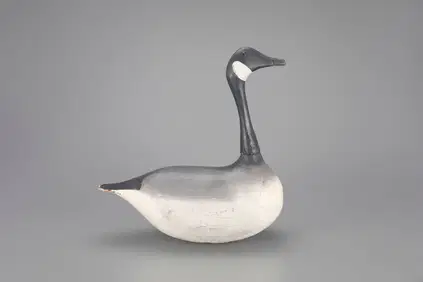
Stick-Up Canada Goose Decoy by Frank L. Himmel (1873-1940)(attr.)Copley Fine Art Auctions4.5(40)See Sold PriceFeb 24, 2024
MATTHEWS c1856 Map Of Upper Canada Ontario Indian Land Agency Divisions Scarce!Luis Porretta Fine Arts4.3(10)See Sold PriceMar 02, 2024
DUNLEVIE c1856 Map Counties Of Gaspe & Bonaventure Quebec Canada SCARCE! #1Luis Porretta Fine Arts4.3(10)See Sold PriceMar 02, 2024
Group of Ten Railroad Photographs, Maps, and Prints - New Jersey, Long Island, and New YorkRail & Road Auctions4.6(165)See Sold PriceMar 07, 2024
[MAP]. [ALBRIZZI, Giambatista, 1698-1777]. Carta Geografica...Potter & Potter Auctions4.6(550)See Sold PriceMar 07, 2024
[VIETNAM]. A group of approx. 120 photographs assembled by African American soldier Vernon CliftonFreeman's | Hindman4.4(1.6k)See Sold PriceFeb 27, 2024
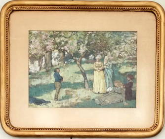
Amazing James Edward Hervey MacDonald Oil BoardAmazing Collectible Galleries4.6(174)See Sold PriceMar 02, 2024
Robert de Vaugondy - Map of Canada - Mer de l' Ouest or Sea of the West and a Northwest PassageProverde Auctions4.3(3)See Sold PriceFeb 28, 2024
Mostly U.S., Some Canada Maps etc (40 Pcs)Grant Zahajko Auctions, LLC4.8(1k)See Sold PriceMar 06, 2024


![[MAP]. [ALBRIZZI, Giambatista, 1698-1777]. Carta Geografica... (1 of 1)](https://p1.liveauctioneers.com/928/318880/171361280_1_x.jpg?height=282&quality=70&version=1707501302)
![[VIETNAM]. A group of approx. 120 photographs assembled by African American soldier Vernon Clifton (1 of 6)](https://p1.liveauctioneers.com/197/319238/171468143_1_x.jpg?height=282&quality=70&version=1707520367)