SoldMap of world by Chamouin 1805Heading: Author: Chamouin, Jean Baptiste Marie Title: Mappe-Monde sur la Projection Reduite de Mercator Place Published: Paris Publisher: Date Published: 1806 Description:See Sold Price
Map of world by Chamouin 1805Title: Mappe-Monde sur la Projection Reduite de Mercator Author: Chamouin, Jean Baptiste Marie Description: Copper-engraved map, hand-colored in outline; uncolored pictorial cartouche. 29x45 cm. (11½See Sold Price
Map of world by Chamouin 1805Title: Mappe-Monde sur la Projection Reduite de Mercator Author: Chamouin, Jean Baptiste Marie Description: Copper-engraved map, hand-colored in outline; uncolored pictorial cartouche. 29x45 cm. (11½See Sold Price
SoldGroup of Early MapsIncluding, Monroe County maps, 1872. NYS Topography maps, 1905. World Map, 1805. Adams Syn Chronological Chart or Map of History. Max 27 1/2" x 13 1/2".See Sold Price
SoldEngraved world map by Samuel Dunn, 1805, 14'' x 20Engraved world map by Samuel Dunn, 1805, 14'' x 20 1/2''.See Sold Price
SoldDUNN, SAMUEL. A New Chart of the World on Mercator'sDUNN, SAMUEL. A New Chart of the World on Mercator's Projection. Fine engraved world map on "Ruse & Turner's/1805" watermarked wove paper. 14x20½ inches sheet size, wide margins; strong originalSee Sold Price
SoldWorld.- Chamouin (Jean Baptiste Marie) Mappe-Mondes surWorld.- Chamouin (Jean Baptiste Marie) Mappe-Mondes sur Diverses Projections, double hemisphere world map centered on Sumatra, with 5 further smaller projections, with allegorical vignette and title iSee Sold Price
MAP - Washington, D.C.. ClerkWashington, D.C.. Thomas Clerk, Plan of the City of Washington, 1805 (circa). Black & White. This is the second Scottish plan of Washington, DC. The plan bears some resemblance to the size and configuSee Sold Price
MAP - Washington, D.C.. ClerkWashington, D.C.. Thomas Clerk, Plan of the City of Washington, 1805 (circa). Hand Color. This very rare, small plan of Washington was issued in volume one of Encyclopaedia Perthensis; or Universal DiSee Sold Price
SoldMAP - Southern & Southeast Asia. AkermanSouthern & Southeast Asia. Andrew Akerman, Mappa Geogr: Indiae Orients Eller Geogr: Charta Ofwer Ostindien, 1805 (circa). Hand Color. This uncommon, Swedish map depicts the southern portion of Asia inSee Sold Price
Sold1805 ATLAS Maps Universal Geography William Guthrie Ill1805 ATLAS Maps Universal Geography William Guthrie Illustrated Navigation Asia William Guthrie was well known during the mid-18th-century for his many contributions to world history, especially throuSee Sold Price
SoldMAPSMAPS Book, A New System of Modern Geography, or a General Description of the Most Remarkable Countries Throughout the Known World by Benjamin Davies (Philadelphia: Jacob Johnson & Co.), 1805. First edSee Sold Price
Horsey: Pictorial Map, World According to Ronald ReganTitle/Content of Map: 1982 Horsey Pictorial Map of the World According to Ronald Regan -- The World According to Ronald Regan Date Printed: 1982 Cartographer: D Horsey / Seattle Post-Intelligencer SizSee Sold Price
SoldGuthrie, William 1798 Map World of Mercators ProjectionCopper Engraved Map Published 1798, London for "A New Geographical, Historical and Commercial Grammar..." by William Guthrie. The maps are by John Senex, Thomas Kitchin and others. Folds as issued. PaSee Sold Price
SoldGuthrie, William 1798 Map. World HemispheresCopper Engraved Map Published 1798, London for "A New Geographical, Historical and Commercial Grammar..." by William Guthrie. The maps are by John Senex, Thomas Kitchin and others. Folds as issued. PaSee Sold Price
SoldStrategic Russian Map, World War I, 1917Strategic Russian Map, World War 1. 54x62 cm. Date: 1917 Shipping: Domestic: Flat-rate of $10.00 to anywhere within the contiguous U.S. International: Foreign shipping rates are determined by destinatSee Sold Price
SoldLochhead (Pub) 1811 Rare Map. World HemisphereCopper Engraved Map Published 1811 by William Lochhead, Berwick for "Modern Geography: And a Compendious General Gazetteer" Rare. Folds as issued. Paper Size: 17 x 11 inch (43 x 28cm) Some creasing. VSee Sold Price
SoldCary: US Western Territory/Great Lakes Region Map, 1805Map: A New Map of Part of the United States of North America, exhibiting the Western Territory, Kentucky, Pennsylvania, Maryland, Virginia &c., also the lakes Superior, Michigan, Huron, Ontario & ErieSee Sold Price
SoldRapkin, John 1860 Map. World HemispheresSteel Engraved Map Published 1860 by The London Printing & Published Company, London for "The Royal Dictionary-Cyclopedia for Universal Reference" by Thomas Wright. Drawn & Engraved by John Rapkin. FoSee Sold Price
Tallis World Map World on Mercator's Projection 1851Tallis World Map The World on Mercator's Projection 1851. T. Jefferys, 1757 London, 6 X 10.6 In.. This Is an Attractive and Charming Double Hemisphere Map, Colored, and Framed. it Is Set Against a BacSee Sold Price
Bradford: Set of 2 Antique Maps, World in HemispheresTitle/Content of Map: Set of 2 Maps together World in globular projection by Bradford Date Printed: 1835 Cartographer: T.G. Bradford Material/Medium: Paper Size: 9 1/2" x 13" each A comprehensive AtlaSee Sold Price
Sold[MAP - WORLD]. BOWEN, Emanuel (d. 1767). Niewe en[MAP - WORLD]. BOWEN, Emanuel (d. 1767). Niewe en Naukeurige Kaart des geheelen Aardbodems' [Amsterdam,] 1744. Engraved map hand-colored in outline, visible area 515 x 610 mm, matted and framed (unexaSee Sold Price
SoldBecker, F. C1838 Antique Map. World on Mercator's Proj.Steel Engraved Map with outline hand color Published C1838, London for "A Complete and Universal English Dictionary" by the Rev. James Barclay et al. Maps by F. Becker and others. Paper Size: 10.5 x 8See Sold Price
Horsey: Pictorial Map World According to Ronald ReaganTitle/Content of Map: 1982 Horsey Pictorial Map of the World According to Ronald Reagan -- The World According to Ronald Reagan Date Printed: 1982 Cartographer: D Horsey / Seattle Post-Intelligencer SSee Sold Price
17TH C. WORLD MAP BY NICOLAES VISSCHER (NETHERLANDS, 1618-1709)Thomaston Place Auction Galleries4.4(393)See Sold PriceFeb 24, 2024
Eretz Israel Map Postcard - World Zionist OrganizationLevy Auction House4.3(11)See Sold PriceFeb 27, 2024
Vintage Full Color World Map LithographThe Benefit Shop Foundation Inc.4.3(2.9k)See Sold PriceFeb 28, 2024
Nova Totius Full Color Geographical World MapThe Benefit Shop Foundation Inc.4.3(2.9k)See Sold PriceFeb 28, 2024
An Ebel Voyager automatic wristwatch with world time function, the dial with world map and dateClaydon Auctioneers Ltd4.3(125)See Sold PriceFeb 25, 2024
World map.- Macrobius (Ambrosius Aurelius Theodosius) In somnium Scipionis, Libri II. Saturnaliorum,Forum Auctions4.3(53)See Sold PriceFeb 29, 2024
Blackie (Pub) 1882 Folio Map. World on Mercators ProjectionAlbion Auctions4.6(341)See Sold PriceMar 01, 2024
1849 Hand Colored Blair Map of World in HemispheresMatthew Bullock Auctioneers4.7(1.8k)See Sold PriceMar 02, 2024
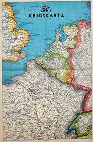
Vintage Map - Krigskarta - War Map - Second World War, published 1940Proverde Auctions4.3(3)See Sold PriceFeb 28, 2024


![[MAP - WORLD]. BOWEN, Emanuel (d. 1767). Niewe en (1 of 1)](https://p1.liveauctioneers.com/197/161882/81723385_1_x.jpg?height=282&quality=70&version=1581711364)