ATLAS of ANTIENT GEOGRAPHY by SAMUEL BUTLER 1843John McInnis Auctioneers,LLC4.6(504)See Sold PriceFeb 24, 2024
18TH C. ANTIQUE MAP: FRENCH & INDIAN WAR, FRAMEDThomaston Place Auction Galleries4.4(389)See Sold PriceFeb 24, 2024
Rand McNally Railroad Map Cabinet w/ 21 Railroad MapsRail & Road Auctions4.6(165)See Sold PriceMar 08, 2024
Keith Haring - Ink on New York Map, Best Buddies, Inscribed, Signed, and DatedSapphire Auction Gallery4.1(67)See Sold PriceMar 02, 2024
LATE 17TH C. FRENCH MAP OF THE NEW WORLD BY ALEXIS-HUBERT JAILLOT (1632-1712)Thomaston Place Auction Galleries4.4(389)See Sold PriceFeb 24, 2024
Central Railroad of New Jersey Map of Sandy Hook Route-ca. 1903JM Hobby Supply and Railroad Artifact Auctions4.4(126)See Sold PriceFeb 24, 2024
Lot of Six Mixed Atlas Box Cars-HO Scale-New in BoxJM Hobby Supply and Railroad Artifact Auctions4.4(126)See Sold PriceFeb 25, 2024
Rand McNally/Santa Fe Railroad Map of Iowa-1912JM Hobby Supply and Railroad Artifact Auctions4.4(126)See Sold PriceFeb 24, 2024
NICOLAES VISSCHER (NETHERLANDS, 1618-1709) MAP OF THE NEW WORLDThomaston Place Auction Galleries4.4(389)See Sold PriceFeb 24, 2024
17TH C. WORLD MAP BY NICOLAES VISSCHER (NETHERLANDS, 1618-1709)Thomaston Place Auction Galleries4.4(389)See Sold PriceFeb 24, 2024
Lot of Six Mixed Atlas Cabooses-HO Scale-New in BoxJM Hobby Supply and Railroad Artifact Auctions4.4(126)See Sold PriceFeb 25, 2024
SoldMap of the Holy Land. Print in 1850.Map of the Holy Land since the Second Crusade in 1149 - 1291. Print in 1850.Print of steel engraving titled „Carte de la Terre Sainte depuis la deuxieme Croisade jusqua la fin de la domination ChretSee Sold Price
Map of the Holy Land. Print in 1850.Map of the Holy Land shared in the 12 Tribes. Print in 1850.Print of steel engraving titled „La Terre Sainte partagee en 12 Tribus .Author A. Houze.Engraved by unknown.From the „Atlas Universel HiSee Sold Price
Map of the Holy Land. Print in 1850.Print of steel engraving titled „Carte de la Terre Sainte pendant la premiere Croisade de 1096 a 1144.Author A. Houze.Engraved by unknown.From the „Atlas Universel Historique et Geographique by A.See Sold Price
SoldMap of the Holy Land. Print in 1850.Map of the Holy Land divided into Kingdoms of Israel and Judahin 975 - 588 J.C. Print in 1850.Print of steel engraving titled „Carte de la Terre Sainte divisee en Royaumes D‘Israel et de Juda de 9See Sold Price
Map of the Holy Land. Print in 1850.Map of The Holy Land divided into 12 governments by Solomon. Print in 1850.Print of steel engraving titled „La Terre Sainte sous Salomon divisee en 12 Gouvernemens .Author A. Houze.Engraved by unknoSee Sold Price
Map of the Holy Land in 1849. Print in 1850.Print of steel engraving titled „Carte de la Terre Sainte en 1849.Author A. Houze.Engraved by unknown.From the „Atlas Universel Historique et Geographique by A. Houze, Paris. 1850.The Holy Land asSee Sold Price
Antique Map Print - Asia - Holy Land - Judea - Palestine - Vaugondy - 1806Title: Antique Map Print - Asia - Holy Land - Judea - Palestine - Vaugondy - 1806 Date: 1806 Material: Paper Dimensions: 12” x 9” inches / 31,5 cm x 24 cm Descritpion: Original 1806 copperSee Sold Price
Map of Canaan Land or Promised Land. Print in 1850.Print of steel engraving titled „Carte de la Terre de Chanaan ou Terre Promise au momem ou Abraham y avion Ay du Monde 2083 av. J. C. 1921 .Author A. Houze.Engraved by unknown.From the „Atlas UnivSee Sold Price
SoldHoly land. 1850 by Thomas.Title: Holy land. 1850 by Thomas. Date/Period: c1850. Materials: Hand colored steel engraved Size: 16 1/2 x 13 1/2 inches. c1850 by Thomas, Cowperthwait & Co. From 'A New Universal Atlas' Published inSee Sold Price
Bartholomew, John 1922 Lot of 4 Maps. Holy LandIncl Persia, Palestine, Asia Minor/Syria/Mesopotamia, and South Western Asia. Large Lithograph Maps Published 1922 by The Times, London for "The Times Survey Atlas of the World" Maps by John George BaSee Sold Price
Bartholomew, John 1922 Lot of 4 Maps. Holy LandIncl Persia, Palestine, Asia Minor/Syria/Mesopotamia, and South Western Asia. Large Lithograph Maps Published 1922 by The Times, London for "The Times Survey Atlas of the World" Maps by John George BaSee Sold Price
Bartholomew, John 1922 Lot of 4 Maps. Holy LandIncl Persia, Palestine, Asia Minor/Syria/Mesopotamia, and South Western Asia. Large Lithograph Maps Published 1922 by The Times, London for "The Times Survey Atlas of the World" Maps by John George BaSee Sold Price
SoldMap of Holy Lands. 1854.Print of hand colored steel engraving .Drawn by L. Dussieux. Engraved by unknown.From „Atlas General De Geographie physique, politique et historique par L. Dussieux. Atlas de Geographie ancienne, duSee Sold Price
SoldBartholomew, John 1922 Lot of 5 Maps Egypt & Holy LandIncl Egypt and The Nile, Lower Egypt, Asia Minor/Syria/Mesopotamia, Palestine and Persia. Large Lithograph Maps Published 1922 by The Times, London for "The Times Survey Atlas of the World" Maps by JoSee Sold Price
Bartholomew, John 1922 Lot of 5 Maps Egypt & Holy LandIncl Egypt and The Nile, Lower Egypt, Asia Minor/Syria/Mesopotamia, Palestine and Persia. Large Lithograph Maps Published 1922 by The Times, London for "The Times Survey Atlas of the World" Maps by JoSee Sold Price
Holyland lithograph print of Hebron, circa 1879 -Holyland lithograph print "Hebron", circa 1879 - uncredited; image size: 11.8 x 7.4cm; matted Product Tags: Holylandish Artwork/Prints, Maps, Prints & Artwork and Judaica from Holyland and from 19th CSee Sold Price
Holyland lithograph print of Hebron, circa 1879 -Holyland lithograph print "Hebron", circa 1879 - uncredited; image size: 11.8 x 7.4cm; matted Product Tags: Holylandish Artwork/Prints, Maps, Prints & Artwork and Judaica from Holyland and from 19th CSee Sold Price
Holyland color print Mount Thabor (Tabor) by W. H.Holyland color print "Mount Thabor" by W. H. Bartlett & J. Cousen, c.1839; image size: 18 x 11.8cm; matted. Product Tags: Holylandish Artwork/Prints, Maps, Prints & Artwork and Judaica from Holyland aSee Sold Price
Holyland color print Mount Thabor (Tabor) by W. H.Holyland color print "Mount Thabor" by W. H. Bartlett & J. Cousen, c.1839; image size: 18 x 11.8cm; matted. Product Tags: Holylandish Artwork/Prints, Maps, Prints & Artwork and Judaica from Holyland aSee Sold Price
Holyland lithograph print of Hebron, circa 1879 -Holyland lithograph print "Hebron", circa 1879 - uncredited; image size: 11.8 x 7.4cm; matted Product Tags: Holylandish Artwork/Prints, Maps, Prints & Artwork and Judaica from Holyland and from 19th CSee Sold Price
Holyland lithograph print of Hebron, circa 1879 -Holyland lithograph print "Hebron", circa 1879 - uncredited; image size: 11.8 x 7.4cm; matted Product Tags: Holylandish Artwork/Prints, Maps, Prints & Artwork and Judaica from Holyland and from 19th CSee Sold Price
Holyland color print Mount Thabor (Tabor) by W. H.Holyland color print "Mount Thabor" by W. H. Bartlett & J. Cousen, c.1839; image size: 18 x 11.8cm; matted. Product Tags: Holylandish Artwork/Prints, Maps, Prints & Artwork and Judaica from Holyland aSee Sold Price
Holyland color print Mount Thabor (Tabor) by W. H.Holyland color print "Mount Thabor" by W. H. Bartlett & J. Cousen, c.1839; image size: 18 x 11.8cm; matted. Product Tags: Holylandish Artwork/Prints, Maps, Prints & Artwork and Judaica from Holyland aSee Sold Price
Holyland lithograph print of Hebron, circa 1879 -Holyland lithograph print "Hebron", circa 1879 - uncredited; image size: 11.8 x 7.4cm; matted Product Tags: Holylandish Artwork/Prints, Maps, Prints & Artwork and Judaica from Holyland and from 19th CSee Sold Price
DAVID ROBERTS - Holy Land / Syria / Egypt etc. 3 x Folio Volumes 1849 Very RareLuis Porretta Fine Arts4.3(10)See Sold PriceMar 02, 2024
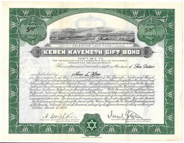
Eretz Israel Map Postcard - World Zionist OrganizationLevy Auction House4.3(11)See Sold PriceFeb 27, 2024
Jerusalem Map for British Soldiers in Palestine - WW2Levy Auction House4.3(11)See Sold PriceFeb 27, 2024
Proposed Sportsground Map - Haifa, Palestine - 1926Levy Auction House4.3(11)See Sold PriceFeb 27, 2024
The Holy Land Tours - Hamburg American Line - 1911Levy Auction House4.3(11)See Sold PriceFeb 27, 2024
18 Booklets Collection - War Graves of Palestine - WWILevy Auction House4.3(11)See Sold PriceFeb 27, 2024
1849 Mitchell School ATLAS 24 MAPS America Holy Land France Africa Egypt AsiaSchilb Antiquarian Rare Books4.8(422)See Sold PriceMar 31, 2024
1872 Holy BIBLE & Hitchcock Analysis Gruden Concordance Theology MAPS Holy LandSchilb Antiquarian Rare Books4.8(422)See Sold PriceMar 31, 2024
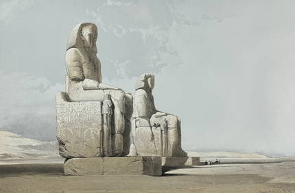
David Roberts - Obelisk of LuxorTrillium Antique Prints & Rare Books4.5(30)See Sold PriceFeb 24, 2024
David Roberts - Approach of the Simoom, Desert of GizehTrillium Antique Prints & Rare Books4.5(30)See Sold PriceFeb 24, 2024
Georg Bockler Map of Ancient Jerulsaem EtchingAuctions at Showplace4.6(731)See Sold PriceApr 07, 2024
TWO ANTIQUE JEWISH NATIONAL FUND CHARITY BOXES. The first one made in Berlin c. 1920J. Greenstein & Co., Inc.4.3(55)See Sold PriceApr 16, 2024