ATLAS of ANTIENT GEOGRAPHY by SAMUEL BUTLER 1843John McInnis Auctioneers,LLC4.5(505)See Sold PriceFeb 24, 2024
18TH C. ANTIQUE MAP: FRENCH & INDIAN WAR, FRAMEDThomaston Place Auction Galleries4.4(393)See Sold PriceFeb 24, 2024
Rand McNally Railroad Map Cabinet w/ 21 Railroad MapsRail & Road Auctions4.6(165)See Sold PriceMar 08, 2024
Keith Haring - Ink on New York Map, Best Buddies, Inscribed, Signed, and DatedSapphire Auction Gallery4(67)See Sold PriceMar 02, 2024
LATE 17TH C. FRENCH MAP OF THE NEW WORLD BY ALEXIS-HUBERT JAILLOT (1632-1712)Thomaston Place Auction Galleries4.4(393)See Sold PriceFeb 24, 2024
Central Railroad of New Jersey Map of Sandy Hook Route-ca. 1903JM Hobby Supply and Railroad Artifact Auctions4.4(127)See Sold PriceFeb 24, 2024
Lot of Six Mixed Atlas Box Cars-HO Scale-New in BoxJM Hobby Supply and Railroad Artifact Auctions4.4(127)See Sold PriceFeb 25, 2024
Rand McNally/Santa Fe Railroad Map of Iowa-1912JM Hobby Supply and Railroad Artifact Auctions4.4(127)See Sold PriceFeb 24, 2024
NICOLAES VISSCHER (NETHERLANDS, 1618-1709) MAP OF THE NEW WORLDThomaston Place Auction Galleries4.4(393)See Sold PriceFeb 24, 2024
17TH C. WORLD MAP BY NICOLAES VISSCHER (NETHERLANDS, 1618-1709)Thomaston Place Auction Galleries4.4(393)See Sold PriceFeb 24, 2024
Lot of Six Mixed Atlas Cabooses-HO Scale-New in BoxJM Hobby Supply and Railroad Artifact Auctions4.4(127)See Sold PriceFeb 25, 2024
SoldCarte d'une Partie de L'Amerique pour la Navigation...Carte d'une Partie de L'Amerique pour la Navigation des Isles et du Golfe de Mexique avec l'interieur des Terres… Henry Popple (d. 1743). Engraved map with original hand-color in outline. PhiladelphSee Sold Price
SoldCarte d'une partie de l'Amerique pour la navigation'The towns of Saint Augustine, Savannah and Port Royal are marked on the Atlantic seaboard of the United States DATE PRINTED: 1740 (This date is printed on the map) IMAGE SIZE: Approx 53.0 x 69.5cm, 21See Sold Price
Carte d'une partie de l'Amerique pour la navigation'The towns of Saint Augustine, Savannah and Port Royal are marked on the Atlantic seaboard of the United States The top image on the right hand side shows the entire map. This map is folding hence theSee Sold Price
Carte d'une partie de l'Amerique pour la navigation'The towns of Saint Augustine, Savannah and Port Royal are marked on the Atlantic seaboard of the United States DATE PRINTED: 1740 (This date is printed on the map) IMAGE SIZE: Approx 53.0 x 69.5cm, 21See Sold Price
Carte d'une partie de l'Amerique pour la navigation'The towns of Saint Augustine, Savannah and Port Royal are marked on the Atlantic seaboard of the United States DATE PRINTED: 1740 (This date is printed on the map) IMAGE SIZE: Approx 53.0 x 69.5cm, 21See Sold Price
Carte d'une partie de l'Amerique pour la navigation'The towns of Saint Augustine, Savannah and Port Royal are marked on the Atlantic seaboard of the United States DATE PRINTED: 1740 (This date is printed on the map) IMAGE SIZE: Approx 53.0 x 69.5cm, 21See Sold Price
Buache: Antique Map of the Caribbean, 1740Carte d'une partie de l'Amerique pour la navigation' Caribbean. The towns of Saint Augustine, Savannah and Port Royal are marked on the Atlantic seaboard of the United States Date Printed: 1740 (ThisSee Sold Price
Buache: Antique Map of the Caribbean, 1740Carte d'une partie de l'Amerique pour la navigation' Caribbean. The towns of Saint Augustine, Savannah and Port Royal are marked on the Atlantic seaboard of the United States DATE PRINTED: 1740 (ThisSee Sold Price
Buache: Antique Map of the Caribbean, 1740Title/Content of Map: Carte d'une partie de l'Amerique pour la navigation' Caribbean. The towns of Saint Augustine, Savannah and Port Royal are marked on the Atlantic seaboard of the United States ThiSee Sold Price
SoldPhilippe Buache (French, 1700-1773)Philippe Buache (French, 1700-1773), "Carte d'une Partie de l'Amerique pour la Navigation des Isles et du Golfe du Mexique...Reduite de la Carte Angloise en 20 feuilles par Mr. Popple", 1740, Paris, tSee Sold Price
SoldPhilippe Buache Map, 1740Philippe Buache, "Carte d'Une Partie de l'Amerique pour la Navigation des Isles et du Golfe du Mexique avec l'interieur des Terres depuis Bermude jusqu'a Cayenne", Paris, 1740, hand-colored map, basedSee Sold Price
SoldPhilippe Buache MapPhilippe Buache, "Carte d'Une Partie de l'Amerique pour la Navigation des Isles et du Golfe du Mexique avec l'interieur des Terres depuis Bermude jusqu'a Cayenne", Paris, 1740, hand-colored map, basedSee Sold Price
SoldPhil Buache antique map Gulf Of MexicoArtist: Popple, Ms. with several corrections and augmentations by Phil Buache Title: Carte d'une Partie de A'merique pour la Navigation des Isles et du Golfe du Mexique avec Interieur des Terres. DateSee Sold Price
SoldCarte de D'une Partie de L'Amerique Septentrionale...Carte de D'une Partie de L'Amerique Septentrionale, qui Contient Partie de la Nle. Espagne et de la Louisiane… Pierre Marie Francois de Pages (1748 - 1793). Engraved map. Paris, c. 1767. 13 1/4 x 18See Sold Price
SoldLarge Post-Revolutionary Map of Eastern and CentralLarge Post-Revolutionary Map of Eastern and Central North AmericaLe Rouge, George-Louis. Carte D'Une Partie De L'Amérique Septentrionale, pour fervir a l'Histoire de la derniére Guerre (Paris, 1See Sold Price
Meares map of northwest coast c.1790Title: Carte de la Partie Interieur de l'Amerique Septentrionale... Navigation Interieur depuis la Baye d'Hudson jusqua la Cote Nord-Ouest Author: Meares, John Description: Copper-engraved map25x46 cmSee Sold Price
SoldMeares map of northwest coast c.1790Title: Carte de la Partie Interieur de l'Amerique Septentrionale... Navigation Interieur depuis la Baye d'Hudson jusqua la Cote Nord-Ouest Author: Meares, John Description: Copper-engraved map25x46 cmSee Sold Price
Three copper-engraved charts/views of the West CoAuthor: La Pérouse, Jean François Galaup de Description: Includes: Carte Générale d'une Partie de la Côte du Nord-Ouest de l'Amérique reconnue par les Frégates Françaises La Boussole et l'AstrSee Sold Price
SoldLa Perouse. Côte du Nord-Ouest de l'AmériqueLa Perouse (Jean Francois Galoup de) Carte Générale d'une Partie de la Côte du Nord-Ouest de l'Amérique,North-west coast of America from Alaska to California, extending from Mount St. Elie toSee Sold Price
"Carte D'Une Partie Du Grand Ocean a l'E. et SE. de la"Carte D'Une Partie Du Grand Ocean a l'E. et SE. de la Nouvelle Guinee pour l'intelligence du Voyage de la Fregate Espagnole la Princesa commandee par D.Franco.Antonio Maurelle, en 1781" [See Sold Price
SoldHenry Popple (d. 1743)Henry Popple (d. 1743), "Nouvelle Carte Particuliere de l'Amerique... Caroline Meridionale, la Floride, la Louisiane, le Mexique, le Jucatan, le Guatimala, le Darien, & une Partie de Cuba", 1742, AmstSee Sold Price
SoldBrue Nouvelle Carte du MexiqueBRUE, Adrien Hubert (1786-1832). Nouvelle Carte du Mexique, Et D'une Partie des Provinces Unies De Lâ'Amerique Centrale, Dedi' á l'Acadamie Royale des Sciences de l'Institute de France. Engraved mSee Sold Price
Rare map of U.S. with gold regionHeading: Author: Bes, A. and F. Dubreuil Title: Carte Générale Du Théâtre De La Guére dans les États-Unis de L'Amérique avec Une Carte du Mexique pour suivre les Opérations Militaires Place PSee Sold Price
SoldRare map of U.S. with gold regionHeading: Author: Bes, A. and F. Dubreuil Title: Carte Générale Du Théâtre De La Guére dans les États-Unis de L'Amérique avec Une Carte du Mexique pour suivre les Opérations Militaires Place PSee Sold Price
AMBROISE TARDIEU c1822 Napoleonic War Map GermanyLuis Porretta Fine Arts4.3(10)See Sold PriceMar 02, 2024
Corneille - La femme masquee comme pour une fete, feteDane Fine Art Auctions4.4(498)See Sold PriceMar 07, 2024
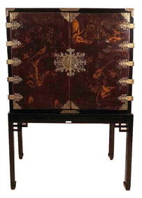
Pierre CHAREAU (1883-1950) Table de salle à manger variante du modèle MB97 en placage et bois deValoir Pousse-Cornet4.3(4)See Sold PriceFeb 24, 2024
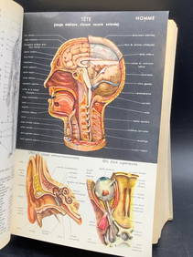
1959 PETIT LAROUSSE French Dictionary EncyclopediaThe Benefit Shop Foundation Inc.4.3(2.9k)See Sold PriceMar 06, 2024
Map of St. Kitts and Nevis Depot de la Marine, Paris, 1758Global Auctions Company4.3(36)See Sold PriceMar 03, 2024
1758 MAP PARTIE DE LA MER GLACIALE contenants La Nouvelle Zemble RUSSIA antiqueJasper524.5(9.9k)See Sold PriceFeb 27, 2024
1845 Delisle/Bauche Map of Martinique -- Carte de l'Isle de la Martinique Colonie Francoise de l'uneJasper524.5(9.9k)See Sold PriceFeb 27, 2024
Partie de la Coste d'Afrique depuis Tanit…' Southern Mauritania BELLIN 1746 mapJasper524.5(9.9k)See Sold PriceFeb 28, 2024
Partie de la Coste d'Afrique'. Southern Mauritania BELLIN/SCHLEY 1747 old mapJasper524.5(9.9k)See Sold PriceFeb 28, 2024
Carte de l'Afrique propre, de la Numidie… North Africa. LAPIE 1829 old mapJasper524.5(9.9k)See Sold PriceFeb 28, 2024
Carte de L'Algérie et de la Régence de Tunis' ANDRIVEAU-GOUJON Algeria 1850 mapJasper524.5(9.9k)See Sold PriceFeb 28, 2024
HUGO VICTOR: (1802-1885)International Autograph Auctions Europe S.L.4.5(52)See Sold PriceMar 14, 2024
SAND GEORGE: (1804-1876)International Autograph Auctions Europe S.L.4.5(52)See Sold PriceMar 14, 2024
MAUPASSANT GUY DE: (1850-1893) 'If my request would embarrass M. Massenet too much, please tellInternational Autograph Auctions Europe S.L.4.5(52)See Sold PriceMar 14, 2024
Saint Laurent Rive Gauche, Collection Prêt à Porter, Printemps-Eté 1987 'Rose Sch...Bonhams4.1(320)See Sold PriceMay 17, 2024