17TH C. ENGLISH LINEAR MAP BY OGILBY, FRAMEDThomaston Place Auction Galleries4.4(386)See Sold PriceFeb 24, 2024
MAP - PIETER SCHENK / VALK / JANSSEN Hand Colored superb Map Central Italy c1702Luis Porretta Fine Arts4.3(10)See Sold PriceMar 02, 2024
OGILVY & BOWEN c1736 Original Map of Oxfordshire Berkshire Etc.Luis Porretta Fine Arts4.3(10)See Sold PriceMar 02, 2024
CHARLES ROLLIN c1828 Ceasar Hand Colored Africa Military MapLuis Porretta Fine Arts4.3(10)See Sold PriceMar 02, 2024
MAP - Dufour, A. H. ( Malte / Brun ) :MAP - ESPAGNE PARTIE SUD DIVISEE EN PROVINCES ANCIENNES ( MAPLuis Porretta Fine Arts4.3(10)See Sold PriceMar 02, 2024
RIGOBERT BONNE c1787 Original Colored Map Germany & Region 15" x 12"Luis Porretta Fine Arts4.3(10)See Sold PriceMar 02, 2024
AMBROISE TARDIEU c1822 Napoleonic War Map GermanyLuis Porretta Fine Arts4.3(10)See Sold PriceMar 02, 2024
MAP - AMBROISE TARDIEU c1822 Napoleonic Miltary Map GermanyLuis Porretta Fine Arts4.3(10)See Sold PriceMar 02, 2024
1822 Rare Map by Ambroise Tardieu Napoleon Caldiero Battle of Vento 17" x 11Luis Porretta Fine Arts4.3(10)See Sold PriceMar 02, 2024
THOMAS MOULE 1837 Colored Map of Warwickshire Framed vgcLuis Porretta Fine Arts4.3(10)See Sold PriceMar 02, 2024
PIETER SCHENK / VALK / JANSSEN Hand Colored Map of Rhodes Greece ca1702 vgcLuis Porretta Fine Arts4.3(10)See Sold PriceMar 02, 2024
STICH & DRUCK c1888 Map Austrian Alps 20" x 16"Luis Porretta Fine Arts4.3(10)See Sold PriceMar 02, 2024
SoldMap of Switzerland and of Liechtenstein. 1847.Print of steel engraving, hand colored titled „Die Schweiz auch Fürstenthum Liechtenstein“.Author Justus Perthes.Engraved by unknown.From Justus Perthes – Stielers, „Schul-atlas“ – 1847,See Sold Price
Map of Germany and Switzerland. 1847.Print of steel engraving, titled „Deutschland Niederlande Belgien und Schweiz.Author Justus Perthes.Engraved by unknown.From Justus Perthes Stielers, „Schul-atlas 1847, Germany.Justus Perthes PublSee Sold Price
Map of Southwestern Germany and Switzerland. 1847.Print of steel engraving, hand colored titled „Sdwestliches Deutschland und Schweiz.Author Justus Perthes.Engraved by unknown.From Justus Perthes Stielers, „Schul-atlas 1847, Germany.Justus PertheSee Sold Price
SoldTANNERS TRAVELING MAP ,1847 & BURRS MAP OF NYPUBLISHED BY J. H. COLTON, 1833, HANDBOOKSSee Sold Price
SDUK: Antique Astronomy Celestial Star Map, 1847Title/Content of Map: '[STARS. IV., Winter Solstice]' ASTRONOMY CELESTIAL. Star map. Star chart. IV. Winter Solstice Date Printed: The alignment of the constellations is shown as at 1830; this date isSee Sold Price
SoldTallis, John (Pub) 1852 Map. SwitzerlandSteel Engraved Map with Original Outline Hand Color Published 1852-56 by John Tallis, London for "The Universal Pronouncing Dictionary" by Thomas Wright. Drawn & Engraved by John Rapkin. Centre fold aSee Sold Price
SoldBritish Greywell Indenture Map 1847British land indenture from 1847, ink on vellum, contract between Basingstoke Canal Navigation and the landowner, Baron Dorchester, to do work on the Greywell Canal, a road and tunnel which still exisSee Sold Price
SoldFremont's Narrative with Rufus Sage Map 1847Heading: Author: Frémont, John Charles Title: Narrative of the Exploring Expedition to the Rocky Mountains, in the year 1842; and to Oregon and North California, in the Years 1843-44 Place PublishedSee Sold Price
SoldMAP - Switzerland. ChatelainSwitzerland. Henry Abraham Chatelain, Carte Ancienne de la Suisse avec des Remarques Abregees sur les Divers Evenemens et Revolutions qui y sont Arrivees, et Particulierement Celles qui ont Donne LieuSee Sold Price
SoldFremont's Narrative with Rufus Sage Map 1847Title: Narrative of the Exploring Expedition to the Rocky Mountains, in the year 1842; and to Oregon and North California, in the Years 1843-44 Author: Frémont, J[ohn] C[harles] Description: 427 + [4See Sold Price
[PRINT]. PHELPS. Ornamental Map.... 1847[PRINT]. PHELPS, ENSIGNS & THAYER (publishers). Ornamental Map of the United States & Mexico. 1847. [Along bottom]: Entered According to Act of Congress in the Year 1846, by Humphrey Phelps, iSee Sold Price
SoldFremont's Narrative with Rufus Sage Map 1847Title: Narrative of the Exploring Expedition to the Rocky Mountains, in the year 1842; and to Oregon and North California, in the Years 1843-44 Author: Frémont, J[ohn] C[harles] Description: 427 + [4See Sold Price
SoldFremont's Narrative with Rufus Sage Map 1847Title: Narrative of the Exploring Expedition to the Rocky Mountains, in the year 1842; and to Oregon and North California, in the Years 1843-44 Author: Frémont, J[ohn] C[harles] Description: 427 + [4See Sold Price
SoldJ. Calvin's Guide to U.S. with map 1847Heading: Author: Smith, John Calvin Title: The Illustrated Hand-Book, A New Guide for Travelers through the United States of America: Containing a description of the states, cities, towns, villages,See Sold Price
Tanner: Antique New York State Pocket Map, 1847Map: 1847 Tanner New York State Pocket Map - New York Cartographer: H. Tanner (Family) Year / Place: 1847 Philadelphia Map Dimensions: 21 x 25 in. Condition: Map is in very good condition, with a fewSee Sold Price
George Grote. SEVEN LETTERS... SWITZERLAND, 1847.[History/Switzerland]. George Grote. SEVEN LETTERS CONCERNING THE POLITICS OF SWITZERLAND, Pending the Outbreak of the Civil War In 1847... With the Addition of an Unpublished Letter written by the AuSee Sold Price
SoldJ. Calvin's Guide to U.S. with map 1847Heading: Author: Smith, John Calvin Title: The Illustrated Hand-Book, A New Guide for Travelers through the United States of America: Containing a description of the states, cities, towns... with theSee Sold Price
MAP - Switzerland. MercatorSwitzerland. Mercator/Hondius, Helvetia, 1613 (published). Hand Color. This charming small map of Switzerland depicts the lakes, mountainous topography, rivers, and cities of the country. The map is aSee Sold Price
SoldMAP - Switzerland. CluverSwitzerland. Philipp Cluver, Helvetiae Conterminarumq Terrarum Antiqua Descriptio, 1660 (circa). Hand Color. This handsome small map shows ancient Switzerland. The mountainous topography is well illusSee Sold Price
MAP - Switzerland & Germany. OrteliusSwitzerland & Southern Germany. Abraham Ortelius, Basiliensis Territorii Descriptio Nova, Auctore Sebastiano Munstero [on sheet with] Circulus sive Liga Sueviae, Vulgo Schwabische Kraiss, 1572 (dated)See Sold Price
Battle of Cerro Gordo map, 1847Heading: (Mexican-American War) Author: Title: Battle of Cerro Gordo, April 17th & 18th 1847 from Surveys Made by Major Turnbull & Capt. McClellan. Topl. Engs. Drawn by Capt. McClellan. Place PublishSee Sold Price
SoldMAP, Switzerland, Mercator/HondiusSwitzerland. Mercator/Hondius, Helvetia cum Finitimis Regionibus Confaederatis, from Gerardi Mercatoris - Atlas sive Cosmographicae, 1619 (published). Hand Color. This is an early, handsome map of SwiSee Sold Price
SoldMAP, Switzerland, VisscherSwitzerland. Nicolas Visscher, Exactissima Helvetiae Rhaetiae, Valesia Caeterorumq, Confaederatorum ut et Finitimorum Populorum Regionum Tabula, 1680 (circa). Hand Color. This highly detailed map of SSee Sold Price
Thomson, John (Pub) 1825 Map. SwitzerlandCopper Engraved Map Published 1825 by John Thomson, Edinburgh for "The Edinburgh School Atlas" by N. R. Hewitt. Maps Engraved by Hewitt. Engraved Vignette in corner. Original Outline Hand Colour. RareSee Sold Price
LATE 17TH C. FRENCH MAP OF THE NEW WORLD BY ALEXIS-HUBERT JAILLOT (1632-1712)Thomaston Place Auction Galleries4.4(386)See Sold PriceFeb 24, 2024
18TH C. ANTIQUE MAP: FRENCH & INDIAN WAR, FRAMEDThomaston Place Auction Galleries4.4(386)See Sold PriceFeb 24, 2024
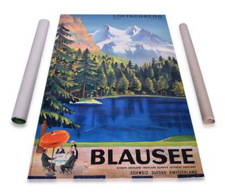
Three Switzerland and Spain Railway Advertising Travel PostersRail & Road Auctions4.6(165)See Sold PriceMar 07, 2024
Keith Haring - Ink on New York Map, Best Buddies, Inscribed, Signed, and DatedSapphire Auction Gallery4(67)See Sold PriceMar 02, 2024
Rand McNally Railroad Map Cabinet w/ 21 Railroad MapsRail & Road Auctions4.6(165)See Sold PriceMar 08, 2024
Putnam - First Map of the State of Ohio by Rufus PutnamTrillium Antique Prints & Rare Books4.5(30)See Sold PriceFeb 24, 2024
1636 MAP of SWITZERLAND DAS WIFISPURGERGOU antique 15 by 19"Jasper524.5(9.8k)See Sold PriceFeb 27, 2024
James Ridgway (1815 - 1847) - Antique Fruit Print of CherryProverde Auctions4.3(3)See Sold PriceFeb 28, 2024
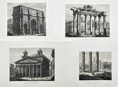
Domenico Amici - Set of 4 prints - Tempio di Giove Statore - Arco di Costantino in Rome, ItalyProverde Auctions4.3(3)See Sold PriceFeb 28, 2024
Joseph Meyer - Set of 20 Prints - Views of Austria - Germany - Italy - Switzerland - France - SpainProverde Auctions4.3(3)See Sold PriceFeb 28, 2024
C. R. Knight - Falls of the Rhine at Schaffhausen - SwitzerlandProverde Auctions4.3(3)See Sold PriceFeb 28, 2024
Set of 3 Maps - Netherlands - Belgien - Switzerland - J. BarlowProverde Auctions4.3(3)See Sold PriceFeb 28, 2024


![[PRINT]. PHELPS. Ornamental Map.... 1847 (1 of 4)](https://p1.liveauctioneers.com/514/95456/48680540_1_x.jpg?height=282&quality=70&version=1477936169)