Sold18th c. Hand-colored map18th c. Hand-colored map- A New Map of Turkey- in Europe, divided into all its provinces, with the adjacent countries in Europe and Asia, drawn chiefly from the maps published by the Imperial AcademySee Sold Price
Sold18th C. Engraved / Colored Map of Central AmericaNorthern Europe, United Kingdom or colonies, ca. 18th to early 19th century CE. An engraved page from a book showing a color map of "Mexico or New Spain" clearly labeled in English. "The Pacific or SoSee Sold Price
SoldGroup of Seventeen Double Sheet Atlas Maps of Europe,Group of Seventeen Double Sheet Atlas Maps of Europe, 18th c., by Robert de Vaugondy, unframed, Each- H.- 22 in., W.- 30 1/2 in.See Sold Price
SoldThree Antique New Orleans MapsThree Antique New Orleans Maps, 18th c., incl. 2 from Bellin's Petit Atlas Maritime and one published by London Magazine, sights 7 1/2 in. x 9 in. to 8 1/2 in. x 11 3/4 in., framed alikeSee Sold Price
SoldGroup of Fifteen Double Sheet Atlas Maps of Europe, 18tGroup of Fifteen Double Sheet Atlas Maps of Europe, 18th c., by Robert de Vaugondy, unframed, Each- H.- 22 in., W.- 30 1/2 in.See Sold Price
Sold1799 Map ITALY JOHN CARY "A New Map of Piedmont" 18th CA beautifully engraved and colored 18th Century map of Italy. This piece is entitled: "A New Map of Piedmon the Duchies of Savoy and Milan; and the Republic of Genoa; with their Subdivisions." EngraveSee Sold Price
SoldEleven Antique Maps of EuropeEleven Antique Maps of Europe , 16th-18th c., incl. Ptolemy from 1541 (4); a Blaeu map of "Regno di Napoli", Hondius map of the Holy Land, de Wit map of Southern Spain, an undated manuscript map of MeSee Sold Price
SoldTWO 18TH C. MAPS *NEW ENGLAND, NEW YORK, NEW JERSTWO 18TH C. MAPS *NEW ENGLAND, NEW YORK, NEW JERSEY, & PENSILVANIA (SIC) BY H. MOLL, GEOGRAPHER* AND NORTH AMERICA SIGNED NAME UNCERTAIN; 14 1/2 IN X 9 1/4 IN & NA IS 10 1/4 IN X 8 INSee Sold Price
SoldA New Map of the Cherokee Nation, 18th C."A New Map of the Cherokee Nation with the Names of the Towns & Rivers, engraved from an Indian Draught by T. Kitchin ." Depicts Native American villages in western North Carolina, Tennessee, KentuckySee Sold Price
SoldTwo maps, 18thc., "A New and Accurate Map of the PrTwo maps, 18thc., "A New and Accurate Map of the Present War in North America. 1797" hand colored 9"x13.75" and "Principal Seat of War, 1756" 8"x10".See Sold Price
Sold18th c. Map of America- Emanuel Bowen18th c. Map- ''A New and Accurate Map of America''- engraved map, 1748, from John Harris- ''Complete Collection of Voyages and Travels'', short repaired separation at top of centerfold. 14 3/8 x 17 5/See Sold Price
SoldPAIR 18TH C NEW ENGLAND/MASSACHUSETTS MAPSPair 18th century New England / Massachusetts maps. Includes "A Map of the Province of Massachusetts Bay, and Colony of Rhode Island, with part of Connecticut, New Hampshire, and Vermont." marked in lSee Sold Price
Sold18th C. Hand-Colored Map of New EnglandAn 18th C. hand-colored engraved map of New England, Nova Scotia, New France, or Canada, with the Islands of Newfoundland, Cape Breton, St. John's, by Jacques-Nicholas Bellin. Framed under glass. MatSee Sold Price
SoldFramed antique map of New Jersey. Circa 18th C.Framed antique map of New Jersey. Circa 18th C. Entitled "Porti Della Nouva York E Perthamboy". from IL Gaziettien Americano Map measures 8" tall x 7" wide. Buyer to pay $35.00 shipping and handling,See Sold Price
SoldEARLY MAP TITLED A NEW MAP OF Y NORTH PARTS OFAMERICA ACCORDING TO THE DIVISION THERE OF BY THE ARTICLES OF PEACE IN 1763. 8 1/2" X 11". MAP APPEARS TO BE 18TH C WITH SOME HAND COLORING AND IS FRAMED AND MATTED. WE DID NOT REMOVE FROM FRAME AND ISee Sold Price
Sold(18th c) NEW AND ACCURATE MAP OF THE WORLDAs recorded by circum-navigators Ferdinand Magellan, Sir Francis Drake and Commodore Anson by Eman Bowen geographer to His Majisty. Vol. 1 page 6. 16 x 23 inches.See Sold Price
SoldTwo 18th C. Maps & Two 18th C. EngravingsLot consists of three 18th century engravings--1st item: Mid 18th century map titled "A New Map of Carolina by Robert Morden"; page taken from a book or publication "A Description of Carolina"; map siSee Sold Price
Sold18thc Map of Asia, John Senex, EnglandFramed English hand-colored engraved map by John Senex "A New Map of Asia" TITLE: A New Map of Asia from the latest Observations Most Humbly Inscrib'd to the Right Honbl. George Earl of Warrington & cSee Sold Price
SoldMap of North America, 1797Ca. late 18th c. engraved map, on laid paper. "A New Map of North America Shewing all the New Discoveries, 1797." Sheet 9.5" x 8.25". From Morse's Gazetteer of America.See Sold Price
SoldPhaenomena Motuum Irregularium, celestial mapPhaenomena Motuum Irregularium, celestial map, 18th c., Doppelmayr/Homann, each sheet: 19"h x 22.5"w (sight), 43.5"h x 26.75"w (framed ensuite) Provenance: Property from a New York Corporate CollectioSee Sold Price
SoldILLUMINATIONS, ETC.Two, together with pastel on paper signed Augusta and a reproduction 17th/18th c. New York City map (all framed); Largest: 18 1/2" x 1 3/4" (irregular) (sheet)See Sold Price
CHIPPENDALE TIGER MAPLE SLANT LID DESKThomaston Place Auction Galleries4.4(393)See Sold PriceFeb 24, 2024
LATE 18TH C. VERY LARGE CHART OF NORTHEAST CANADA BY DES BARRES (1721-1824), 1780, FRAMEDThomaston Place Auction Galleries4.4(393)See Sold PriceFeb 24, 2024
LATE 17TH C. FRENCH MAP OF THE NEW WORLD BY ALEXIS-HUBERT JAILLOT (1632-1712)Thomaston Place Auction Galleries4.4(393)See Sold PriceFeb 24, 2024
EARLY 18TH C. DUTCH CHART OF PACIFIC OCEAN BY FREDERIK DE WIT (1629-1706) WITH CALIFORNIA AS ANThomaston Place Auction Galleries4.4(393)See Sold PriceFeb 24, 2024
EARLY 18TH C. MAP OF ITALY, FRAMEDThomaston Place Auction Galleries4.4(393)See Sold PriceFeb 24, 2024
18TH C. ANTIQUE MAP: FRENCH & INDIAN WAR, FRAMEDThomaston Place Auction Galleries4.4(393)See Sold PriceFeb 24, 2024
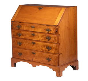
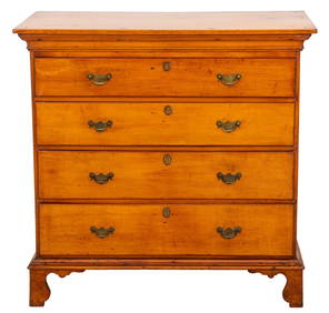
American Federal Period Maple Chest, Late 18th C.Auctions at Showplace4.6(740)See Sold PriceMar 03, 2024
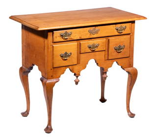
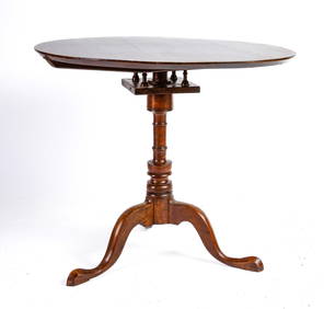
(18th c) NEW HAMPSHIRE CHERRY BIRD CAGE TEA TABLEJohn McInnis Auctioneers,LLC4.5(505)See Sold PriceFeb 25, 2024
Two (2) Antique 18th C. Copper Engraved Framed Maps - America & EuropeMagnusson Art Group4.5(53)See Sold PriceMar 14, 2024
Map: An 18thC engraved and hand coloured map of Buckinghamshire after Robert Morden. Approx. 8 1/4"Claydon Auctioneers Ltd4.3(125)See Sold PriceFeb 26, 2024
Map: An 18thC engraved and hand coloured map of Northamptonshire, with description ofClaydon Auctioneers Ltd4.3(125)See Sold PriceFeb 26, 2024
Map: An 18thC engraved and hand coloured map of North America and South America, titled DeClaydon Auctioneers Ltd4.3(125)See Sold PriceFeb 26, 2024
Map: An 18thC engraved map of Bedfordshire titled An Accurate Map of the County of Bedford DividedClaydon Auctioneers Ltd4.3(125)See Sold PriceFeb 26, 2024
Map: An 18thC engraved map titled A New and Improved Map of Oxfordshire.. after Thomas Kitchin.Claydon Auctioneers Ltd4.3(125)See Sold PriceFeb 26, 2024
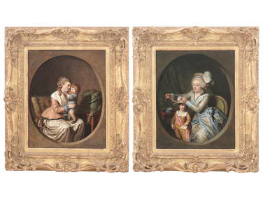
18TH C FRENCH PAINTINGS BY PIERRE ALEXANDRE WILLEAntique Arena Inc.4.5(878)See Sold PriceMar 09, 2024
18TH C. MAPLE AND PINE SINGLE DRAWER TAVERN TABLE.William Smith Auctions4.6(147)See Sold PriceMar 06, 2024
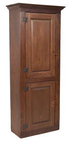
18TH C. NEW ENGLAND RED STAINED CHIMNEY CUPBOARD.William Smith Auctions4.6(147)See Sold PriceMar 06, 2024