ATLAS of ANTIENT GEOGRAPHY by SAMUEL BUTLER 1843John McInnis Auctioneers,LLC4.6(502)See Sold PriceFeb 24, 2024
18TH C. ANTIQUE MAP: FRENCH & INDIAN WAR, FRAMEDThomaston Place Auction Galleries4.4(386)See Sold PriceFeb 24, 2024
Rand McNally Railroad Map Cabinet w/ 21 Railroad MapsRail & Road Auctions4.6(165)See Sold PriceMar 08, 2024
Keith Haring - Ink on New York Map, Best Buddies, Inscribed, Signed, and DatedSapphire Auction Gallery4(67)See Sold PriceMar 02, 2024
LATE 17TH C. FRENCH MAP OF THE NEW WORLD BY ALEXIS-HUBERT JAILLOT (1632-1712)Thomaston Place Auction Galleries4.4(386)See Sold PriceFeb 24, 2024
Central Railroad of New Jersey Map of Sandy Hook Route-ca. 1903JM Hobby Supply and Railroad Artifact Auctions4.4(126)See Sold PriceFeb 24, 2024
Lot of Six Mixed Atlas Box Cars-HO Scale-New in BoxJM Hobby Supply and Railroad Artifact Auctions4.4(126)See Sold PriceFeb 25, 2024
Rand McNally/Santa Fe Railroad Map of Iowa-1912JM Hobby Supply and Railroad Artifact Auctions4.4(126)See Sold PriceFeb 24, 2024
NICOLAES VISSCHER (NETHERLANDS, 1618-1709) MAP OF THE NEW WORLDThomaston Place Auction Galleries4.4(386)See Sold PriceFeb 24, 2024
17TH C. WORLD MAP BY NICOLAES VISSCHER (NETHERLANDS, 1618-1709)Thomaston Place Auction Galleries4.4(386)See Sold PriceFeb 24, 2024
Lot of Six Mixed Atlas Cabooses-HO Scale-New in BoxJM Hobby Supply and Railroad Artifact Auctions4.4(126)See Sold PriceFeb 25, 2024
Antique African Map by d'AbbevilleMade by Nicolas Sanson d'Abbeville; titled "Afrique"; published in Paris, c.1715; measures approximately 7.8" x 10.7"; uncolored; hand-laid paper has some light toning overall but strong impression; tSee Sold Price
Antique Asian Map by d'AbbevilleMade by Nicolas Sanson d'Abbeville et fils; titled "L'Asie"; published in Paris, 1715; plate issued in 1699; measures approximately 7.4" x 10.9"; uncolored; hand-laid paper has some light toning overaSee Sold Price
ANTIQUE WOODCUT MAP OF KINGDOM OF CONGO166. [AFRICAN WOODCUT MAP] Antique woodcut fold-out map, ca. 1729, b/w, 15½"x12½", illustrating "Little Kaskais Land," "Part of The Kingdom of Congo," with Rio Congo River and "Sonho Lands above theSee Sold Price
Sanson: Antique Map of North America, 1735Title: Amerique Septentrionale par N. Sanson d'Abbeville Geographe du Roy, Small 1735 French map with California as an Island and misshapen Great Lakes Map maker: Nicolas Sanson, Introduction a l'histSee Sold Price
Sanson: Antique Map of North America, 1735Title: Amerique Septentrionale par N. Sanson d'Abbeville Geographe du Roy. Small 1735 French map with California as an Island and misshapen Great Lakes Map maker: Nicolas Sanson, Introduction a l'histSee Sold Price
Sold2V Collectible Books DECORATIVE ANTIQUE AFRICAN HISTORY2V Collectible Books DECORATIVE ANTIQUE AFRICAN HISTORY Britain and Boer in South Africa Murat Halstead Majuba Hill Joseph Chamberlain Paul Kruger Gold Diamonds War Fold-Out Map Heroes of the Dark ConSee Sold Price
SoldAntique Map: Geographiae Sacre Tabula quae Totius OrbisNicolas Sanson D'Abbeville (1600-1667), was called "the father of French Cartography" 10.25" ht. x 13.25" wd, framed, 9" ht. x 12" wd, site. Excellent appearance. Not examined outside of frame.See Sold Price
ENGRAVED AFRICAN MAP ASBEN BURNU KASHNAAfrican map engraving depicting Asben, Burnu, Kashna, Guber, Daura, Cano, Solan, Cabi, Nyffe, Noro, Haussa and River Julbi or Joliba. Paper measures 11" (28cm) length.See Sold Price
ENGRAVED AFRICAN MAP ASBEN BURNU KASHNAAfrican map engraving depicting Asben, Burnu, Kashna, Guber, Daura, Cano, Solan, Cabi, Nyffe, Noro, Haussa and River Julbi or Joliba. Paper measures 11" (28cm) length.See Sold Price
20th Century Photographic Reproduction Print of an20th Century Photographic Reproduction Print of an African Map of Madagascar. Depicts a colored map with native people throughout composition. Unevenly trimmed and burned along the edges. No apparentSee Sold Price
Levasseur: Antique Map of Africa, 1852Title/Content of Map: 1852 Levasseur Map of Africa -- Afrique Date Printed: 1852, Paris Cartographer: V. Levasseur Size: 11 x 16.5 in. A highly decorative nineteenth century map of the African contineSee Sold Price
Baldwin & Cradock/SDUK: Antique Map of Africa, 1836Africa The highly detailed map of the African continent from the Society for the Diffusion of Useful Knowledge atlas. Except for the as yet unexplored interior, includes many place names and topographSee Sold Price
1908 AFRICAN EXPLORATIONS by EDOUARD FOA antique ILLUSTRATED FOLIO w/ MAPSResultats scientifiques des voyages en Afrique ... Publies sous les auspices du Museum National d'Historie Naturelle. by FOA, EDOUARD Paris: Imprimerie Nationale, 1908 Later three-quarters black morocSee Sold Price
SoldOrtelius: Antique Map of Ethipoia & East Africa, 1592Title/Content of Map: Ethipoia & East Africa. The Prester John Map by Ortelius Date Printed: 1592 Cartographer: Abraham Ortelius Material/Medium: Paper Size: 16" x 21" Hand colored copperplate engraveSee Sold Price
Santini / d'Anville: Antique Map of Africa, 1784Afrique publiée sous les auspices de Monseigneur le Duc d'Orléans Prémier Prince du Sang. Par le Sr. d'Anvillé. À Venise, Chez Remondini [Africa published under the auspices of Monseigneur the DuSee Sold Price
SoldVisscher: Antique Map of Africa, 1670Title: Africæ Accurata Tabula. 17th century Visscher map of Africa Map maker: Nicolas Visscher Place and Year: Amsterdam, c. 1670 Dimensions: 43.5 x 54 cm (17¼ x 21¼ in) Technique: Copperplate engrSee Sold Price
SoldAspin: Antique Map of Africa with European SettlementsMap: Modern Africa With European Settlements Publication Date: 1818 Authors: J. BARFIELD, ASPIN, JEHOSHOPHAT Publisher: J. BARFIELD Size: Quarto – 10.30 H x 11.25 W Inches Modern Africa With EuropeaSee Sold Price
SoldHomman Heirs: Antique Map of Africa, 1746Map: Africa Date Printed: 1746 Cartographer: Homann Heirs Material/Medium: Paper Size: 23 1/4" x 21" Printed in Nuremberg. Thick paper. Hand colored copperplate engraved. Beautiful baroque style cartoSee Sold Price
SoldAntique framed map of Indian Ocean, Asia, AustraliaTitle/Content of Map: Antique framed map of Indian Ocean, Asia, Australia Date Printed: 1713 Cartographer: Aa, Pieter van der Size (in): 11 x 8 Very attractive framed copper-engraved antique map by PiSee Sold Price
SoldZatta: Antique Map of Africa, 1770Title/Content of Map: Africa by Zatta Date Printed: 1770 Cartographer: Antonio Zatta Material/Medium: Paper Size: 17" x 13" Published in Venice. Hand colored. Copperplate engraved. Antonio Zatta (1722See Sold Price
Santini / Janvier: Antique Map of Africa, 1784Title/Content of Map: 'L'Afrique divisée en ses principaux Etats assujettie aux Observations Astronomique par le Sr. Janvier Géographe. À Venise par Francois Santini rue St. Justine près la dite lSee Sold Price
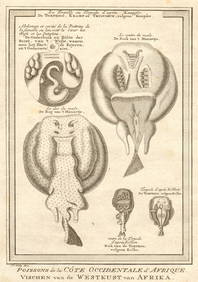
Bellin: Antique Map of West Coast of Africa, 1759Title/Content of Map: Carte de la Coste Occidentale d'Afrique Depuis le Cap Blanc Jusqu'a a Tanit Date Printed: 1759 Cartographer: Bellin, Jacques Nicolas Size (inches): 6 x 9 Outline coloring. SmallSee Sold Price
SoldTallis: Antique Map of Africa, 1853Map: Africa Date Printed: 1853 Cartographer: Tallis Material/Medium: lithograph Size: 10 3/4" x 14" Original lithograph by John Tallis & Company of London, c. 1853. Map vignettes feature North AfricaSee Sold Price
Carriat: Antique Map of Moroco, 1900sMap: Moroco Date Printed: 1900's Cartographer: Carriat Material/Medium: print Size: 40 x 30 in SM Mohammed V, Moroco Please note that this lot has a confidential reserve. When you leave a bid in advanSee Sold Price
AFRICAN PORTS.Alexandria Cape Town Cairo Port Natal(Durban).JOHNSTON 1906 mapJasper524.5(9.8k)See Sold PriceFeb 28, 2024
RHINOS. African rhino- hunt. Dogs. rifles. (Field Sports- Edward Orme) 1814Jasper524.5(9.8k)See Sold PriceFeb 28, 2024
West African serpents. Snake scorpion worm lizard pangolin iguana 1747 printJasper524.5(9.8k)See Sold PriceFeb 28, 2024
WEST AFRICA explorers' routes. Beaufort Gray Park Dochard Caillie. SDUK 1874 mapJasper524.5(9.8k)See Sold PriceFeb 28, 2024
Partie de la Coste d'Afrique depuis Tanit…' Southern Mauritania BELLIN 1746 mapJasper524.5(9.8k)See Sold PriceFeb 28, 2024
Pintado or Guinea-Hen. African Swan, or Gambian Stork. West African birds 1745Jasper524.5(9.8k)See Sold PriceFeb 28, 2024
Afrique Pays… sud du Lac Tchad 30 Central African Republic VANDERMAELEN 1827 mapJasper524.5(9.8k)See Sold PriceFeb 28, 2024
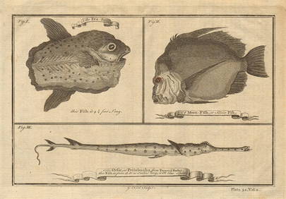
Ocean sunfish. Opah Moonfish. Orsie Petinbuaba Filefish. West African Fish 1745Jasper524.5(9.8k)See Sold PriceFeb 28, 2024
Partie de la Coste d'Afrique'. Southern Mauritania BELLIN/SCHLEY 1747 old mapJasper524.5(9.8k)See Sold PriceFeb 28, 2024
BRITISH AFRICAN COLONIES. West Africa Ascension St. Helena Mauritius 1876 mapJasper524.5(9.8k)See Sold PriceFeb 28, 2024
West African fruit. Kola nut. Guava fruit. Kalabash Calabash tree 1745 printJasper524.5(9.8k)See Sold PriceFeb 28, 2024
NORTH AFRICA. 'Biledulgerid', a former North African country. MALLET 1683 mapJasper524.5(9.8k)See Sold PriceFeb 28, 2024
Oiseaux de Guinée'. West African birds. Parrots. Cape Coast eagle 1748 printJasper524.5(9.8k)See Sold PriceFeb 28, 2024
Oiseaux de Guinée. West African birds. Sestro Ouidah Guinea pheasants 1748Jasper524.5(9.8k)See Sold PriceFeb 28, 2024
African Reptiles & Birds. Horned viper Grey crowned crane Flamingo Penguin 1748Jasper524.5(9.8k)See Sold PriceFeb 28, 2024
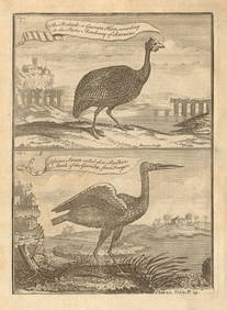
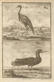
West African Birds. Crane Demoiselle. Alcatrazi or Mad-Bird. Albatross 1745Jasper524.5(9.8k)See Sold PriceFeb 28, 2024
West African fish. Torpedo or electric rays after Kempfer. SCHLEY 1747 printJasper524.5(9.8k)See Sold PriceFeb 28, 2024
Carte de L'Algérie et de la Régence de Tunis' ANDRIVEAU-GOUJON Algeria 1850 mapJasper524.5(9.8k)See Sold PriceFeb 28, 2024
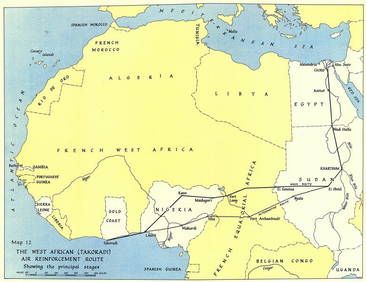
West Africa WW2 Nigeria Sudan Egypt. Takoradi air reinforcement route 1954 mapJasper524.5(9.8k)See Sold PriceFeb 28, 2024
CENTRAL AFRICA. International African Association (Congo) Gabon Angola 1889 mapJasper524.5(9.8k)See Sold PriceFeb 28, 2024
WEST AFRICAN PLANTS. Whydah Pease, The Cotton Tree, The Maniok Root 1746 printJasper524.5(9.8k)See Sold PriceFeb 28, 2024
AFRICAN ISLANDS.Mauritius Madagascar Madeira Canaries St Helena 1897 old mapJasper524.5(9.8k)See Sold PriceFeb 28, 2024
NORTH AFRICAN FLAGS. Tripoli Tunis Algiers. Libya Tunisia Algeria. HOUNSELL 1873Jasper524.5(9.8k)See Sold PriceFeb 28, 2024