ATLAS of ANTIENT GEOGRAPHY by SAMUEL BUTLER 1843John McInnis Auctioneers,LLC4.6(504)See Sold PriceFeb 24, 2024
18TH C. ANTIQUE MAP: FRENCH & INDIAN WAR, FRAMEDThomaston Place Auction Galleries4.4(389)See Sold PriceFeb 24, 2024
Rand McNally Railroad Map Cabinet w/ 21 Railroad MapsRail & Road Auctions4.6(165)See Sold PriceMar 08, 2024
Keith Haring - Ink on New York Map, Best Buddies, Inscribed, Signed, and DatedSapphire Auction Gallery4.1(67)See Sold PriceMar 02, 2024
LATE 17TH C. FRENCH MAP OF THE NEW WORLD BY ALEXIS-HUBERT JAILLOT (1632-1712)Thomaston Place Auction Galleries4.4(389)See Sold PriceFeb 24, 2024
Central Railroad of New Jersey Map of Sandy Hook Route-ca. 1903JM Hobby Supply and Railroad Artifact Auctions4.4(126)See Sold PriceFeb 24, 2024
Lot of Six Mixed Atlas Box Cars-HO Scale-New in BoxJM Hobby Supply and Railroad Artifact Auctions4.4(126)See Sold PriceFeb 25, 2024
Rand McNally/Santa Fe Railroad Map of Iowa-1912JM Hobby Supply and Railroad Artifact Auctions4.4(126)See Sold PriceFeb 24, 2024
NICOLAES VISSCHER (NETHERLANDS, 1618-1709) MAP OF THE NEW WORLDThomaston Place Auction Galleries4.4(389)See Sold PriceFeb 24, 2024
17TH C. WORLD MAP BY NICOLAES VISSCHER (NETHERLANDS, 1618-1709)Thomaston Place Auction Galleries4.4(389)See Sold PriceFeb 24, 2024
Lot of Six Mixed Atlas Cabooses-HO Scale-New in BoxJM Hobby Supply and Railroad Artifact Auctions4.4(126)See Sold PriceFeb 25, 2024
SoldNapoleonic Map by DelamarcheMap titled "Carte Generale de L'Empire Francais et du Royaume D'Italie" by Delamarche, Paris, 1813. Map measures 34.5" x 31.5" and exhibits folds, tear at left border, trim at left border, and rough eSee Sold Price
SoldVAUGONDY, R. de / DELAMARCHE MAPLa Monarchie des Hebreux sous Salamon, ou le royaume. A fine example of Delamarche's exceptional 1745 map of the Holy Land, Israel, or Palestine. Details the region on both sides of the Jordan River wSee Sold Price
SoldMap, Courier's Field Map, Napoleonic WarsSize of map 19 x 21 1/2 inches. In gold leaved frame 32 1/2 x 43 1/2 inches. This is a Circuli Franconiae , Circa 1720. This is a later map. There is a Wax type paper over lay where the Napoleonic WarSee Sold Price
SoldFelix Delamarche map of Americas 1855Felix Delamarche map of Americas 1855, minor tears and chips to edges, fold down center as should be. 18 5/8 x 12 1/2''See Sold Price
Sold[NAPOLEONIC BINDING]. Map Case or Binding in Styl[NAPOLEONIC BINDING]. Map Case or Binding in Style of Napoleon III.[n.p.] c.1860. Large case or binding (500 x 355 mm). Red morocco elaborately stamped in gilt with bees, eagles, and stars, ceSee Sold Price
Antique French Engraving Felix Delamarche map South America 1838Charles-Francois Delamarche (1740-1817), the founder of the family firm was one of the most important French geographers and mapmakers of the second half of the eighteenth century. Successor to NicolaSee Sold Price
Antique French Engraving Felix Delamarche map of Africa 1838Charles-Francois Delamarche (1740-1817), the founder of the family firm was one of the most important French geographers and mapmakers of the second half of the eighteenth century. Successor to NicolaSee Sold Price
Antique French Engraving Felix Delamarche map South America 1838Charles-Francois Delamarche (1740-1817), the founder of the family firm was one of the most important French geographers and mapmakers of the second half of the eighteenth century. Successor to NicolaSee Sold Price
Antique French Engraving Felix Delamarche map of AfricaCharles-Francois Delamarche (1740-1817), the founder of the family firm was one of the most important French geographers and mapmakers of the second half of the eighteenth century. Successor to NicolaSee Sold Price
Poirson / Tardieu: Napoleonic Era Map of HispaniolaMap Title: Carte de St. Domingue. Cartographer: Poirson/Tardieu Place/Date: Paris / 1802/1804 Size: 16 3/4" x 13 3/4" Condition: outline color; light browning along main fold A beautifully detailed anSee Sold Price
SoldAntique French Engraving Felix Delamarche map UnitedCharles-Francois Delamarche (1740-1817), the founder of the family firm was one of the most important French geographers and mapmakers of the second half of the eighteenth century. Successor to NicolaSee Sold Price
Antique French Engraving Felix Delamarche map of Africa 1838Charles-Francois Delamarche (1740-1817), the founder of the family firm was one of the most important French geographers and mapmakers of the second half of the eighteenth century. Successor to NicolaSee Sold Price
Antique French Engraving Felix Delamarche map South America 1838Charles-Francois Delamarche (1740-1817), the founder of the family firm was one of the most important French geographers and mapmakers of the second half of the eighteenth century. Successor to NicolaSee Sold Price
Antique French Engraving Felix Delamarche map of Africa 1838Charles-Francois Delamarche (1740-1817), the founder of the family firm was one of the most important French geographers and mapmakers of the second half of the eighteenth century. Successor to NicolaSee Sold Price
Delamarche: Map of Asia Coloured by Hand 1831Very beautiful map of Asia coloured by hand Author: Delamarche, Felix Atlas: Atlas de Géographie ancienne du Moyen Age, et moderne Date: 1831 Technique: etching on steel Leaf Dimension: 44x32,5 cm (1See Sold Price
Antique French Engraving Felix Delamarche map SouthCharles-Francois Delamarche (1740-1817), the founder of the family firm was one of the most important French geographers and mapmakers of the second half of the eighteenth century. Successor to NicolaSee Sold Price
Antique French Engraving Felix Delamarche map SouthCharles-Francois Delamarche (1740-1817), the founder of the family firm was one of the most important French geographers and mapmakers of the second half of the eighteenth century. Successor to NicolaSee Sold Price
SoldJigsaw Maps.- Atlas DelamarcheJigsaw Maps.- Atlas Delamarche8 engraved maps with original hand-colouring, mounted on wood and dissected as jigsaw puzzles, each 235 x 470mm., 4 minor losses to 3 pieces from Europe, one fromSee Sold Price
SoldJigsaw Maps.- Atlas DelamarcheJigsaw Maps.- Atlas Delamarche Mappe-Monde; l'Asie, Amerique Septentrionale; ..Meridionale; Europe; Afrique; Belgique; France, 8 engraved maps with original hand-colouring, mounted on wood andSee Sold Price
SoldANTIQUE MAP VENICE CARTE DU PLAN DE VENISEFramed, uncolored map of Carte Du Plan de Venise, etc. detailed nobler families, post Napoleonic era. Map measures 18 1/2" wide x 15 1/2" tall and framed is 24" wide x 21" tall. Some foxing on map. NoSee Sold Price
SoldANTIQUE MAP VENICE CARTE DU PLAN DE VENISEFramed, uncolored map of Carte Du Plan de Venise, etc. detailed nobler families, post Napoleonic era. Map measures 18 1/2" wide x 15 1/2" tall and framed is 24" wide x 21" tall. Some foxing on map. NoSee Sold Price
SoldPAIR HAND COLORED MAPS OF SOUTH AMERICATwo hand colored maps of South America comprising a Delamarche map of South America circa 1843 and an Ambroise Tardieu map of South America circa 1874, unframed. Provenance: From the Estate of C.T. anSee Sold Price
Webster-Knowlton-Hazen European History Maps.Title: Webster-Knowlton-Hazen European History Maps. Napoleonic Empire 1812 Date: c1963 Cartographer: WEBSTER, HUTTON/DANIEL C. KNOWLTON/CHARLES DOWNER HAZEN Size: 33.75Height - 46.75Width Publisher:ASee Sold Price
Sold3 Maps incl: CARTE GENERALE DE L’AFRIQUE... 1820.[India/Africa/Europe]. 3 Maps. ++ Fx. Delamarche. CARTE GENERALE DE L’AFRIQUE Divisee en ses Principaux Etats. Paris: Fx. Delamarche et Chles. Dien, 1820. In margin at lower left: “Gravee par BarrSee Sold Price
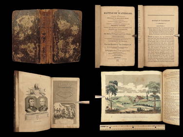
1816 Napoleon 1ed EARLY Battle at Waterloo Account Napoleonic Wars FranceSchilb Antiquarian Rare Books4.8(422)See Sold PriceMar 10, 2024
Central Railroad of New Jersey Map of Sandy Hook Route-ca. 1903JM Hobby Supply and Railroad Artifact Auctions4.4(126)See Sold PriceFeb 24, 2024
Rand McNally/Santa Fe Railroad Map of Iowa-1912JM Hobby Supply and Railroad Artifact Auctions4.4(126)See Sold PriceFeb 24, 2024
PERIOD PASTEL PORTRAIT OF AN UNIDENTIFIED GENERAL OFFICER, NAPOLEONIC WARS, 29TH FOOT, UNDERThomaston Place Auction Galleries4.4(389)See Sold PriceFeb 24, 2024
17TH C. WORLD MAP BY NICOLAES VISSCHER (NETHERLANDS, 1618-1709)Thomaston Place Auction Galleries4.4(389)See Sold PriceFeb 24, 2024
LATE 17TH C. FRENCH MAP OF THE NEW WORLD BY ALEXIS-HUBERT JAILLOT (1632-1712)Thomaston Place Auction Galleries4.4(389)See Sold PriceFeb 24, 2024
18TH C. ANTIQUE MAP: FRENCH & INDIAN WAR, FRAMEDThomaston Place Auction Galleries4.4(389)See Sold PriceFeb 24, 2024
NICOLAES VISSCHER (NETHERLANDS, 1618-1709) MAP OF THE NEW WORLDThomaston Place Auction Galleries4.4(389)See Sold PriceFeb 24, 2024
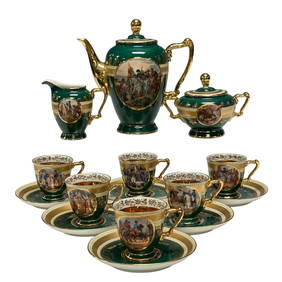
Royal Vienna - Carlsbad Napoleonic Scenes Tea Service SetPremier Auction Galleries4.3(329)See Sold PriceMar 09, 2024
AMBROISE TARDIEU c1822 Napoleonic War Map GermanyLuis Porretta Fine Arts4.3(10)See Sold PriceMar 02, 2024
MAP - AMBROISE TARDIEU c1822 Napoleonic Miltary Map GermanyLuis Porretta Fine Arts4.3(10)See Sold PriceMar 02, 2024
Ambroise TARDIEU c1822 Map Venice Napoleon Italian Campaign 17" x 11"Luis Porretta Fine Arts4.3(10)See Sold PriceMar 02, 2024
1822 Rare Map by Ambroise Tardieu Napoleon Caldiero Battle of Vento 17" x 11Luis Porretta Fine Arts4.3(10)See Sold PriceMar 02, 2024
Nova Totius Full Color Geographical World MapThe Benefit Shop Foundation Inc.4.3(2.9k)See Sold PriceFeb 28, 2024
Keith Haring - Ink on New York Map, Best Buddies, Inscribed, Signed, and DatedSapphire Auction Gallery4.1(67)See Sold PriceMar 02, 2024
Rand McNally Railroad Map Cabinet w/ 21 Railroad MapsRail & Road Auctions4.6(165)See Sold PriceMar 08, 2024
Putnam - First Map of the State of Ohio by Rufus PutnamTrillium Antique Prints & Rare Books4.5(30)See Sold PriceFeb 24, 2024
Robert de Vaugondy - Map of Canada - Mer de l' Ouest or Sea of the West and a Northwest PassageProverde Auctions4.3(3)See Sold PriceFeb 28, 2024


![[NAPOLEONIC BINDING]. Map Case or Binding in Styl (1 of 1)](https://p1.liveauctioneers.com/839/16283/5405553_1_x.jpg?height=282&quality=70&version=1213723478)