Sold5 Pacific island maps[Pacific Islands]. 5 engraved maps. ++ [La Perouse]. Chart Of Necker Island [Hawaii]. Neale engraver. Lon: G.G & J. Robinson, 1798. 14 1/2 x 17 7/8 in. on thin paper. Folds, short tear in margin. InseSee Sold Price
Sold(5) Antique Framed Maps of Fiji, Pacific IslandsGroup of (5) framed antique maps of Fiji and surrounding Pacific Islands, including a map "Chart of the Feejee Islands by the U.S. E.x. E.x. 1840" engraved by Edward Yeager in Philadelphia, one "PubliSee Sold Price
World.Title: World. Publication Date: c1830 Cartographer:HALL, SIDNEY Publisher: LONGMAN & CO. Brief Description: Detailed small hemisphere maps showing most Pacific islands. Browned. Height: Width: 5.3 ResSee Sold Price
SoldMap of Pacific IslandsProbably 20th, with inset of Sandwich Islands. S: 10.5 inches height, 13 inches width F: 19 inches height, 21.5 inches widthSee Sold Price
Sold-. Vandermaelen (Philippe) 4 sheets of maps of isl-. Vandermaelen (Philippe) 4 sheets of maps of islands in the Pacific Ocean,including sheets no.2, 5, 8, 9, and 10, showing the Marshall Islands, the Mariana Islands, and the Caroline Islands,See Sold Price
Tallis: Antique Map of Polynesia & Pacific Islands 1853Title/Content of Map: Polynesia & the Pacific Islands by Tallis, circa 1853 Date Printed: 1853 Cartographer: John Tallis Material/Medium: Lithograph Dimensions: 10.5" x 14" Original lithograph by JohnSee Sold Price
SoldJOHN TALLIS MAP OF POLYNESIA & PACIFIC ISLANDSWith COA. Steelplate engraving, dated 1851. Spots of hand coloring. Dimensions: (Frame) H 19.25" x W 22.5", (Sight) H 10.5" x W 14" Condition: No issues to note.See Sold Price
World.Reserve Reduced! Title/Content of Map: World. Date: c1830 Cartographer: HALL, SIDNEY Material/Medium: LONGMAN & CO. Size: 5.3Width Detailed small hemisphere maps showing most Pacific islands. Browned.See Sold Price
Pacific Ocean Its Islands & CoastsTitle/Content of Map: Pacific Ocean Its Islands & Coasts Date Printed: 1838 Cartographer: EVANS, W. GARDNER Size: 12X9.5 Division into four regions, three of which are Eastern Oceanica or Polynesia, CSee Sold Price
45 Nautical Maps, 1850-1900Collection of 45 Nautical maps from 1850-1900, to include: 2 Japan, 3 South America, 1 North America, 5 Phillipines, 6 Australia, 3 France, 2 Africa, 15 China and Provinces, 8 Pacific Island and ChinaSee Sold Price
SoldSDUK: Map of Polynesia or Islands in the Pacific, 1840Map: Polynesia or Islands in the Pacific Cartographer: Society for the Diffusion of Useful Knowledge Place & Date: London / 1840 Size: 15 5/8" x 12 1/4" A fascinating sheet from the SDUK atlas, featurSee Sold Price
Map of Polynesia Or Islands in the Pacific Ocean,Created by J & C Walker, this engraving was produced for the Society for the Diffusion of Useful Knowledge in June 1840, showing 20 maps on one sheet, 34.5 x 41.2 cm. Tooley 1172.See Sold Price
Pacific islands from Vandermaelen's AtlasHeading: Author: Vandermaelen, Philippe Marie Guillaume Title: Océanie No. 1: Archipel de Magellan Place Published: [Brussels] Publisher: Date Published: [1827] Description:See Sold Price
1874 Map of Australia New ZealandTitle: 1874 Map of Australia New Zealand Additional Information: Lithograph map of Australia New Zealand and Pacific Islands by Flemming, German printing, 1874. Colored outling. Fine, measures 17.5 xSee Sold Price
Weller: Antique Map of the Pacific Ocean, 1863Title/Content of Map: 'The Pacific Ocean' Sandwich Islands/Hawaii Australia New Zealand &c. Date Printed: 1863 Image Size: Approx 47.0 x 65.0cm, 18.5 x 25.75 inches (Large); Please note that this is aSee Sold Price
Weller: Antique Map of Pacific Ocean, 1863TITLE/CONTENT OF MAP: 'The Pacific Ocean' Sandwich Islands/Hawaii Australia New Zealand &c. DATE PRINTED: 1863 IMAGE SIZE: Approx 47.0 x 65.0cm, 18.5 x 25.75 inches (Large); Please note that this is aSee Sold Price
SoldThe Wilderness of the North Pacific Coast IslandsAuthor: Sheldon, Charles Description: xvi, 246 pp. Illus. with photo plates; 5 photogravures from drawings by Carl Rungius; 5 maps. 8¼x5¼, original gilt-lettered cloth, gilt cover vignette, top edgeSee Sold Price
Oceanica.Title/Content of Map: Oceanica. Date Printed: 1890 Cartographer: RAND, MCNALLY & CO. Size: 12.75X19.5 50, 51. Islands in the Pacific. On obverse, Abyssinia, on reverse Denmark. From Alden's Home atlasSee Sold Price
The Islands of NEW ZEALAND. Tavai PoenammooTitle/Content of Map: 'THE ISLANDS OF NEW ZEALAND.' Date Printed: The map is indicated to have been correctd to 1844. This edition of the map was published in 1846 Image Size: Approx 40.5 x 33.0cm, 16See Sold Price
The Islands of NEW ZEALAND. Tavai PoenammooTITLE/CONTENT OF MAP: 'THE ISLANDS OF NEW ZEALAND.' DATE PRINTED: The map is indicated to have been correctd to 1844. This edition of the map was published in 1846 IMAGE SIZE: Approx 40.5 x 33.0cm, 16See Sold Price
Sold1700 Pacific sea chart with Island of California andTitle: Mer de Sud ou Pacifique contenant l'Isle de Californe. Map maker: Pierre Mortier Place and Year: Amsterdam, 1700 Dimensions: 60 x 74.5 cm (23.6 x 29.3 in) Technique: Copperplate engraving ColorSee Sold Price
Bellin: Map of Kamchatka & Kurile Islands, 1750Map: Carte du Kamtchatka Cartographer: Bellin Place & Date: Paris / 1750/1760 Size: 11 5/8" x 20 1/8" Condition: b&w; overall age toning; tear in upper right corner repaired and backed; left margin exSee Sold Price
Outline Map of North Eastern Asia,Title/Content of Map: Outline Map of North Eastern Asia, Date: 1848 Cartographer: PALMER, AARON H. Size: 22.25X34.5 "and the Asiatic islands of the Northern Pacific Ocean, drawn from the latest accessSee Sold Price
New Zealand Navy nautical sea chart 1969 mapTITLE/CONTENT OF MAP: 'New Zealand North Island - West Coast - Approaches to Paremata ' DATE PRINTED: Surveyed 1965-67; Published 1969 IMAGE SIZE: Approx 72.0 x 54.5cm, 28.25 x 21.5 inches (Large) TYPSee Sold Price
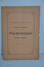
Chicago Rock Island and Pacific RR 11th Annual Report-April 1, 1891JM Hobby Supply and Railroad Artifact Auctions4.4(126)See Sold PriceFeb 24, 2024
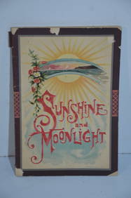
Chicago Rock Island and Pacific RR Book Sunshine and Moonlight-1889JM Hobby Supply and Railroad Artifact Auctions4.4(126)See Sold PriceFeb 24, 2024
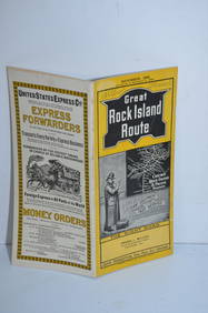
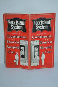
Rock Island RR Iowa and Minnesota Lakes Country Brochure-1926JM Hobby Supply and Railroad Artifact Auctions4.4(126)See Sold PriceFeb 24, 2024
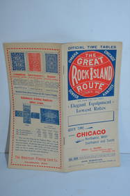
Chicago Rock Island and Pacific RY August 1, 1882 Public TimetableJM Hobby Supply and Railroad Artifact Auctions4.4(126)See Sold PriceFeb 24, 2024
Chicago Rock Island and Pacific RY October 1896 Public TimetableJM Hobby Supply and Railroad Artifact Auctions4.4(126)See Sold PriceFeb 24, 2024
Chicago Rock Island and Pacific RY November 4, 1899 Public TimetableJM Hobby Supply and Railroad Artifact Auctions4.4(126)See Sold PriceFeb 24, 2024
Chicago Rock Island and Pacific RY August 1903 Westbound Edition Public TimetableJM Hobby Supply and Railroad Artifact Auctions4.4(126)See Sold PriceFeb 24, 2024
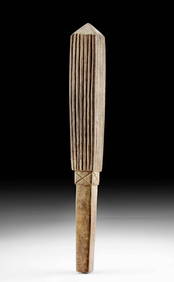
South Pacific Island Malekula Vanuatu Stone IdolTimeLine Auctions Ltd.4.5(183)See Sold PriceMar 08, 2024
Gorham Chicago, Rock Island and Pacific Railroad Flatware - Elmwood Teaspoon and Blackstone Iced-TeaRail & Road Auctions4.6(165)See Sold PriceMar 07, 2024
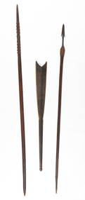
Ethnographic Collector's Lot. Late 19th-Early 20th C.Material Culture4.6(765)See Sold PriceFeb 29, 2024
Three Chicago Rock Island & Pacific Railroad Playing Card Decks From The 1890sRail & Road Auctions4.6(165)See Sold PriceMar 08, 2024
Vintage Framed Pine Island & Lacoste Island MapThe Benefit Shop Foundation Inc.4.3(2.9k)See Sold PriceMar 06, 2024
Lot Of Vintage Railroad Santa Fe Rock Island Frisco Union Pacific MatchbooksRapid Estate Liquidators and Auction Gallery4.5(1.1k)See Sold PriceFeb 24, 2024
Geographical, Statistical, and Historical Map of the Leeward Islands.Jasper524.5(9.8k)See Sold PriceFeb 27, 2024
Plan de la Baye & Isle d'Arguim'. Mauritania. Arguin island. BELLIN 1746 mapJasper524.5(9.8k)See Sold PriceFeb 28, 2024
Churchill & Nieuhof 1744 Map. Batavia Jakarta IndonesiaAlbion Auctions4.6(336)See Sold PriceMar 01, 2024
Vintage Framed Cat Island Nautical Map PrintRapid Estate Liquidators and Auction Gallery4.5(1.1k)See Sold PriceFeb 25, 2024