Marc Chagall-Limited Edition -Paris Opera Ceiling after ChagallArt Legacy Auctions4.5(219)See Sold PriceFeb 24, 2024
Salvador Dali Pantagruel Limited Edition Lithograph Hand signed and numberedArt Legacy Auctions4.5(219)See Sold PriceFeb 24, 2024
Pablo Picasso Bouquet of Peace Collection Domaine Picasso Limited Edition on paper.Art Legacy Auctions4.5(219)See Sold PriceFeb 24, 2024
A RARE MAXFIELD PARRISH JACK AND THE BEANSTALK PRINTSoulis Auctions4.8(953)See Sold PriceFeb 24, 2024
LARGE MECHANICAL PRINT 'STARS' AFTER MAXFIELD PARRISHSoulis Auctions4.8(953)See Sold PriceFeb 24, 2024
Heinrich Aldegrever, etc. 15 old master prints. 16th-17th centuries. Aldegrever works include "ManTremont Auctions4.6(294)See Sold PriceFeb 25, 2024
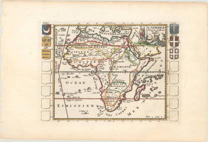
SoldM. Barthelemy. Map of Africa. 1809.Print from copper engraving titled „Afrique“.Author/compiler – M. Barthelemy.Engraved unknown.Notes: After restauration.From „Methode abregee et facile pour apprenre la geographie“ Dediee aSee Sold Price
Map of Africa. 1809.Print from steel engraving titled „Afrique“.Author/compiler – M. Barthelemy.Engraved unknown.Notes: After restauration.From „Methode abregee et facile pour apprenre la geographie“ Dediee a MSee Sold Price
SoldBarclay, James 1809 Hand Col Map. Africa ContinentHand Coloured Copper Engraved Map Published 1809, Leeds for "Barclay's Complete and Universal Dictionary of the English Language..." by the Rev. James Barclay. Folds as issued. Paper Size: 11 x 10 incSee Sold Price
SoldRamsay (David) The History of South-CarolinaRamsay (David) The History of South-Carolina,vol.II only (of 2), engraved folding map, modern half morocco, Charleston, 1809 § Johnson (Harry) Night and Morning in Dark Africa, illustrations,See Sold Price
SoldTallis, John (Pub) 1852 Map. AfricaSteel Engraved Map with Original Outline Hand Color Published 1852-56 by John Tallis, London for "The Universal Pronouncing Dictionary" by Thomas Wright. Drawn & Engraved by John Rapkin. Centre fold aSee Sold Price
SoldLochhead (Pub) 1811 Rare Map. AfricaCopper Engraved Map Published 1811 by William Lochhead, Berwick for "Modern Geography: And a Compendious General Gazetteer" Rare. Folds as issued. Paper Size: 12 x 10 inch (30 x 26cm) Very minor toninSee Sold Price
Sold"Apocryphal" Lewis and Clark with Map, 1809"Apocryphal" account of Lewis and Clark 1809, with fold-out map. Title pages states 5 engravings. The book contains 4 engravings that we believe are original to the book: Sioux Queen (facing title pagSee Sold Price
SoldBarclay, James C1835 Hand Col Map. Africa ContinentHand Colored Copper Engraved Map Published C1835, London for "A Complete and Universal English Dictionary" by the Rev. James Barclay et al. Folds as issued. Paper Size: 11 x 8.5 inch (28 x 22cm) GoodSee Sold Price
SoldGuthrie, William 1798 Map. Africa ContinentCopper Engraved Map Published 1798, London for "A New Geographical, Historical and Commercial Grammar..." by William Guthrie. The maps are by John Senex, Thomas Kitchin and others. Folds as issued. PaSee Sold Price
Sold1796 Map Africa PropriaANTIQUE MAP “AFRICA PROPRIA” CARTGAHE LIBYA, TRIPOLI, MALTA, BY CELLARIUS 1796. From: Geographia Antiqua London. Very Good, measures 15 x 10”, central fold. No Reserve Free shipping for this iteSee Sold Price
SoldNational Geographic Map Africa 1943National Geographic magazine map for Africa . Date: 1943. Editor: Gilbert Grosvenor. Measurement approximate: 31 x 29. Shipping cost: $15.00See Sold Price
SoldAfrica C1800 Map. Africa including the MediterraneanCopper Engraved Map Published C1800, London. Unknown Cartographer/Engraver. Very similar to a Map by Robert Wilkinson. Paper Size: 11.5 x 10 inch (29 x 26cm) Closed split on centre fold. Small chip toSee Sold Price
SoldMAP, Africa, LevasseurAfrica. Victor Levasseur, Afrique, 1850 (circa). Hand Color. This decorative 19th century map of the continent shows the colonial possessions and major tribal kingdoms. The interior is mostly void ofSee Sold Price
Sold1844 MAP AFRICA1844 MAP AFRICA, color, marked 7ink 1844pencil ; approx measure. 16in x 13.5 color atlas folded showing AFRICA lower mediterranean Europe southwest part of asia minor, folded, printed at bottom; PubliSee Sold Price
Sold1700's 1800's Map Africa Egypt Mid East1700's or 1800's map of Africa, Egypt, Mid-East, Libya etc. Measures 18" x 24" and has been professionally framed. Hand watercolored. Plate TXXXI .See Sold Price
Sold"Apocryphal" Lewis & Clark with map, 1809Title: The Travels of Capts. Lewis and Clarke, from St. Louis, by Way of the Missouri and Columbia Rivers, to the Pacific Ocean; Performed in the Years 1804, 1805, & 1806 by Order of the Government ofSee Sold Price
Sold18TH C. MAP, AFRICA AND THE GOLD COAST, BOULTONSamuel Bolton (fl. 1775 - 1800) one large map horizontally cut in half, halves framed separately AFRICA WITH ALL ITS STATES, KINGDOMS, REPUBLICS, REGIONS, ISLANDS...IMPSee Sold Price
SoldHAND COLORED MAP AFRICA BY H S TANNER DATED 1834Framed hand colored map of Africa dated 1834 with map inset of Liberia. Entered according to act of Congress in the year 1834 by H. S., Tanner in the Clerks Office of The Eastern District of PennsylvaSee Sold Price
JOHANN MATTHIAS HASE ENGRAVING MAP AFRICA, 18TH C.Unframed map, engraving on paper, "'Africa Secundum Legitimas Projectionis Stereographicae regulas," Johann Matthias Hase (German, 1684-1742), cartouche with title in lower left corner, illustrated wiSee Sold Price
Travel Poster Sabena Airline Route Map AfricaOriginal vintage Sabena travel advertising poster featuring a map of Europe and Africa designed by Dohet C Pub showing the airline's routes around the world marking the continents, countries, cities aSee Sold Price
Sold"Apocryphal" Lewis & Clark with map, 1809Heading: (Lewis & Clark Expedition) Author: Title: The Travels of Capts. Lewis and Clarke, by Order of the Government of the United States, Performed in the Years 1804, 1805, & 1806, Being Upwards ofSee Sold Price
SoldHAND COLORED MAP AFRICA BY DANIEL BURGESS DATED 18Entered according to act of Congress in the year 1853 by Daniel Burgess & Co., in the Clerks office of the Southern District of New York. Map measures 9" wide x 10 1/2" tall and framed is 12 1/2" wideSee Sold Price
SoldAntique Map, Africa Secundum Legitimas Projectionis,Antique Map, Africa Secundum Legitimas Projectionis, 1739, paper backed, 20x23See Sold Price
Map. Africa and Arabia. 1829.Print from steel engraving titled „Va. Africa et Arabia“.From Schul-Atlas der alten Welt. Published by Gotha Perthes. 1829.Orbis Terrarum Antiquus. School Atlas of the Ancient World edited by D'AnSee Sold Price
AFRICA. French West Africa. Rio de Oro Rio Muni Nigeria. BARTHOLOMEW 1952 mapJasper524.5(9.8k)See Sold PriceFeb 28, 2024
AFRICA. Map pre-dating much exploration. Mountains of Kong. SDUK 1851 oldJasper524.5(9.8k)See Sold PriceFeb 28, 2024
AFRICA. Antiqua; Rome Carthage, start Punic War 1908 old antique map chartJasper524.5(9.8k)See Sold PriceFeb 28, 2024
Pre-colonial Africa. Mountains of Kong/Moon. Caravan routes. THOMSON 1817 mapJasper524.5(9.8k)See Sold PriceFeb 28, 2024
COLONIAL AFRICA. British East/Central/South Africa. Bechuanaland 1899 old mapJasper524.5(9.8k)See Sold PriceFeb 28, 2024
Colonial Africa. British German French Spanish Portuguese Italian TIMES 1900 mapJasper524.5(9.8k)See Sold PriceFeb 28, 2024
COLONIAL AFRICA. British East/Central/South Africa. Bechuanaland 1897 old mapJasper524.5(9.8k)See Sold PriceFeb 28, 2024
AFRICA. Africa. Britannica 9th edition 1898 old antique vintage map plan chartJasper524.5(9.8k)See Sold PriceFeb 28, 2024
Pre-SECOND WORLD WAR AFRICA. European colonies & German mandates 1942 old mapJasper524.5(9.8k)See Sold PriceFeb 28, 2024
NORTH EAST AFRICA. Libya Egypt Sudan Ethiopia Ubangi-Shari Chad 1952 old mapJasper524.5(9.8k)See Sold PriceFeb 28, 2024
ANCIENT NORTH AFRICA Septentrionalis. Mauretania Tripolitana ARROWSMITH 1828 mapJasper524.5(9.8k)See Sold PriceFeb 28, 2024
Africa by Arrowsmith & Lewis 1812 old antique vintage map plan chartJasper524.5(9.8k)See Sold PriceFeb 28, 2024