SoldWALLIS, JOHN. TOUR THROUGH ENGLAND AND WALESWALLIS, John. Tour Through England and Wales, a New Geographical Pastime, folding dissected coloured map published 1794, linen backed, with directions and key printed to each side, 51 x 66cm, in origiSee Sold Price
SoldWallis (John) Tour Through England and WalesWallis (John, publisher) Wallis's Tour Through England and Wales,A New Geographical Pastime, folding hand-coloured engraved map, dissected and linen-backed, 520 x 660 mm., in original slip-casSee Sold Price
SoldWallis, Tour Through England and WalesWallis (John, publisher) Wallis's Tour Through England and Wales,A New Geographical Pastime, folding hand-coloured engraved map, dissected and linen-backed, 520 x 660 mm., in original slip-casSee Sold Price
SoldBetts (John) - Betts's Tour through England & Wales,game map of the counties, tracing a course through 91 points, diagram of the relative heights of mountains in England and Wales compared to St Paul's Cathedral, lower right, engraved map with extensivSee Sold Price
SoldBetts (John) - Betts's Tour through England & Wales,later issue of the game map of the counties, tracing a course through 91 points, diagram of the relative heights of mountains in England and Wales compared to St Paul's Cathedral, lower right, engraveSee Sold Price
SoldWallis (John) - Wallis's Tour through England andengraved map with original hand-colouring, with the side-panels of rules, 510 x 650 mm., dissected and linen-backed, lacking the slipcase, light surface dirt and spotting, letterpress text bears the aSee Sold Price
SoldWallis (John) - Wallis's Tour through England andengraved map with original hand-colouring, with the side-panels of rules, 510 x 650 mm., letterpress text bears the address of Thomas Sorrell, dissected and mounted on linen, with some surface dirt anSee Sold Price
SoldWallis (John) - Wallis's Tour through England andengraved map with original hand-colouring, with the side-panels of rules, 510 x 650 mm., letterpress text bears the address of Thomas Sorrell, dissected and re-laid on modern linen, with some surfaceSee Sold Price
SoldEngland.- Board Game.- Wallis (J. & E.) Wallis's TourEngland.- Board Game.- Wallis (J. & E.) Wallis's Tour Through England and Wales, A New Geographical Pastime, engraved map of England as the game board with hand-colouring, letterpress game rules, leftSee Sold Price
SoldRailwayana - Wallis's New Railway Game or Tour TRailwayana - Wallis's New Railway Game or Tour Through England & Wales, circa 1840, published by E. Wallis of 42 Skinner Street, London, printed by Passmore of Great Guildford Street, London, compSee Sold Price
SoldGame.- Wallis (John) The Geography of England andNO RESERVE Game.- Wallis (John, publisher) The Geography of England and Wales...an Entertaining Game, 52 letterpress cards, one for each county, without folding explanation leaf, some cards with paperSee Sold Price
SoldMAP, Cartographic Game, Britain, WallisCartographic Game, Britain. John Wallis, Wallis's Tour Through the United Kingdom of England, Scotland and Ireland, a New Geographical Game, Comprehending All the Cities, Principal Towns, Rivers &c. iSee Sold Price
Sold[Young (Arthur)] A Six Weeks Tour through the Sout[Young (Arthur)] A Six Weeks Tour through the Southern Counties of England and Wales,second edition, folding engraved frontispiece, contemporary calf, a good clean copy, with the book label ofSee Sold Price
[Young (Arthur)] A Six Weeks Tour, through the Sou[Young (Arthur)] A Six Weeks Tour, through the Southern Counties of England and Wales,second edition, folding engraved plate, illustration, bookplates of John Ruskin and Peter Stockham to pastSee Sold Price
SoldOgilby (John) Britannia: A Survey of the Roads ofOgilby (John) Britannia: A Survey of the Roads of England and Wales in 1675,facsimile reprint with introduction by Dr Helen Wallis, one of 500 copies, blind-embossed morocco by Smith Settle ofSee Sold Price
SoldSpeed (John) England, Wales, Scotland and IrelandSpeed (John) England, Wales, Scotland and Ireland Described,engraved pictorial title and 63 maps, including 2 folding of the British Isles and Yorkshire, by Pieter van den Keere., some ff. triSee Sold Price
SoldSPEED, JOHN. England Wales Scotland.SPEED, JOHN. England Wales Scotland. Engraved title, 63 engraved maps. Oblong 12mo, contemporary vellum, defective; title-page and following two leaves chipped at bottom with loss, corners rounded thrSee Sold Price
SoldSpeed (John) England, Wales, Scotland and IrelandSpeed (John) England, Wales, Scotland and Ireland Described,pictorial title and 63 maps, including 2 folding of the British Isles and Yorkshire, engraved maps, each c.90 x 125mm., but the foldSee Sold Price
SoldBritain.- Speed (John) England, Wales, Scotland andBritain.- Speed (John) England, Wales, Scotland and Ireland Described and Abridged... Form a Farr Larger Voulume Done by John Speed, engraved title, table of distances and 63 maps, 2 folding, a few trSee Sold Price
Speed (John) - England, Wales, Scotland and Ireland,engraved pictorial title and 62 engraved maps including one folding (lacking folding general map 'England, Scotland and Ireland'), folding map with two small closed tears along folds, map 43 with smalSee Sold Price
Speed (John) England, Wales, Scotland and IrelandSpeed (John) England, Wales, Scotland and Ireland Described,engraved pictorial title and 63 maps, including 2 folding of the British Isles and Yorkshire, by Pieter van den Keere., some ff. triSee Sold Price
SoldClarke (E.D.) Tour through...England, Wales,[Clarke (Edward Daniel)] A Tour through the South of England, Wales, and Part of Ireland, made during the Summer of 1791, first edition, 12 tinted aquatint plates, some shaved with loss to capSee Sold Price
Sold'Walker's tour through England & Wales, a new'Walker's tour through England & Wales, a new geographical pastime', published by William Darton, comprising fold-out map in cardboard sleeve, and counters in original box,See Sold Price
SoldRocque (John) England and WalesRocque (John) England and Wales drawn from the most accurate surveys, with inset map of the Scilly Isles, pictorial title, compass rose and ships, engraved folding map with outline hand-colourSee Sold Price
Numismatic Books - Boyne - Tokens Issued in the Seventeenth Century in England, Wales, and IrelandTimeLine Auctions Ltd.4.5(183)See Sold PriceMar 09, 2024
De Passe. Portraits. To include: Charles I (as Prince of Wales), John Foxe, Elizabeth I, Elizabeth ITremont Auctions4.6(293)See Sold PriceFeb 25, 2024
1939 Argentina Airmail Cover Buenos Aires to Mold North Wales EnglandMynt Auctions4.6(680)See Sold PriceFeb 26, 2024
[CHARLES II, KING OF ENGLAND (1630-1685)]. His Majestie’s D...Potter & Potter Auctions4.6(539)See Sold PriceMar 07, 2024
[ENGLISH REFORMATION]. An Inventory of the Plate Belonging ...Potter & Potter Auctions4.6(539)See Sold PriceMar 07, 2024
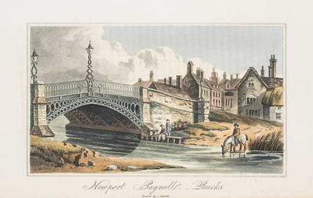
England.- Hassell (John) Tour of the Grand Junction, large paper copy, 24 hand-coloured aquatints,Forum Auctions4.3(52)See Sold PriceFeb 29, 2024
Late 18th century map of England and Wales sampler and two printsFellows4.3(159)See Sold PriceMar 05, 2024


![[CHARLES II, KING OF ENGLAND (1630-1685)]. His Majestie’s D... (1 of 3)](https://p1.liveauctioneers.com/928/318880/171360926_1_x.jpg?height=282&quality=70&version=1707501302)
![[ENGLISH REFORMATION]. An Inventory of the Plate Belonging ... (1 of 2)](https://p1.liveauctioneers.com/928/318880/171360970_1_x.jpg?height=282&quality=70&version=1707501302)