Sold1855 Map PITTSBURG AND ALLEGHENY.& Opening Of TheArtist: Colton's General Atlas Title: THE CITIES OF PITTSBURG AND ALLEGHENY...PENNSYLVANIA, Pittsburgh is shown here colored by ward, showing streets, main buildings, railroads, stations etc. Scale:See Sold Price
Sold1855 MAP OF ANTARCTICA BY G.W. AND C.B. COLTON1855 date entered by J.H. Colton & Co., matted, 16 x 13 inch sight size. Not examined outside of wrappings, appears excellent.See Sold Price
Sold1855 MAP OF THE ARCTIC BY G.W. AND C.B. COLTON1855 date entered by J.H. Colton & Co., matted, 16 x 13 inch sight size. Not examined outside of wrappings, appears excellent.See Sold Price
Sold1855 MAP THE CITY OF CHARLESTON, SOUTH CAROLINAMap of the City of Charleston, South Carolina , published by JH Colton & Co, New York in 1855. Good condition. Paper size 11 1/2"x7". Professionally framed and matted. In frame 11 1/2"x15 1/2"x1". WeiSee Sold Price
Sold1855 Map of The East Coast Of North America 76x411855 Map of The East Coast Of North America 76x41See Sold Price
SoldColton's 1855 Map of VermontColton's 1855 Map of Vermont with hand colored counties 18 x 15"See Sold Price
SoldScarce 1855 map of Calif. – Johnson & BrowningFrom an 1855 edition of Colton’s General Atlas. However, since the imprint of Johnson & Browning appears as publishers of the map, the atlas would have been published no earlier than 1856. Hand coloSee Sold Price
Sold1855 Map of the Kingdom of NaplesAuthor: Colton Title: 1855 Map of the Kingdom of Naples Medium: Ink on Paper Dimensions: 17"X14.5' Map of the Kingdom of Naples, Sardinia and Malta, dated 1855. Engraved by J.H. Colton, considered oneSee Sold Price
Sold1855 Map of Georgetown and the City of Washington by J.H. ColtonColton's Georgetown and the city of Washington: the capital of the United States of America. Issued in 1855 by J. H. Colton (1800-1893). Hand colored. Frame size: 20 1/2" H x 24 3/4" W x 1 1/8" D. SigSee Sold Price
Sold1855 Map of South AfricaAuthor: Colton Title: 1855 Map of South Africa Medium: Ink on Paper Dimensions: 18.5"X16" Map of the South Africa dated 1855. Engraved and published by J.H. Colton in New York. Color coded for territoSee Sold Price
Sold1855 MAP OF IOWA BY J.H. COLTONPre-Civil War map of the state, professionally matted, 13 x 15.5 inch sight size.See Sold Price
Sold1855 Map North America by G. Virtue1855 map of North America by G. Virtue. Measures 13.375 in. x 9.875 in. G-VG/VG. Unframed, loose and not glued or mounted. If lot is absent of a condition report a condition report may be requested viSee Sold Price
Sold1855 map of Virginia by G. W. ColtonItem: 1855 map of Virginia by G. W. Colton Description: Great hand color and clean. Virginia before West Virginia became a separate state. Insets of Richmond and Norfolk. From the 1856 edition of ColtSee Sold Price
Scarce 1855 map of U.S. w/large territorial bordersScarce and collectible 1855 example of Cowperthwait, Desilver & Butler map of the U.S., at a time when the west was experiencing some of its most unusual US territorial configurations. Oregon TerritorSee Sold Price
Hungerford Bridge Station-on-thames Plan, 1855 MapHungerford Bridge Station-on-thames Plan. Charing Cross Precursor, 1855 Map. Size: Approx 30.5 x 62.0cm, 12 x 24.25 inches; Please note that this is a folding map. Antique map, prepared for consideratSee Sold Price
Sold1855 Map of PrussiaTitle: 1855 Map of Prussia Author: Colton Medium: Ink on Paper Dimensions: 17.5"X15" Map of Prussia(modern day territory around the Baltic and other surrounding European states) dated 1855. Engraved aSee Sold Price
Sold1855 Map of Ancient RomeAuthor: D'Anville Title: 1855 Map of Ancient Rome Medium: Ink on Paper Dimensions: 20"X14" Map of Ancient Rome re-published 1855. Drawn by D'Anville cartographer to the King of France. Originally publSee Sold Price
1855 Map of East IndiesTitle: 1855 Map of East Indies Author: Colton Medium: Ink on Paper Dimensions: 17"X15" Map of East Indies dated 1855. Engraved and published by J.H. Colton one of the american leaders of mapmaking betSee Sold Price
Sold1855 Map of Charleston and SavannahTitle: 1855 Map of Charleston and Savannah Medium: Ink on Paper Dimensions: 17"X14.5" Description: Map of Charleston and Savannah dated 1855. Printed and published by Colton in New York. Key upper midSee Sold Price
SoldScarce Colton 1855 map of Texas, Johnson/BrowningScarce large map of Texas with 1855 date, but with Johnson & Browning imprint. The Johnson & Browning imprint was found in only the 1859 Colton atlas and 1860 and 1861 Johnson Family atlases. This mapSee Sold Price
SoldFramed 1855 Map Of California.This color map has an inset at the upper right of the City of San Francisco. It was published by J.H. Colton & Co. of New York. It is in exquisite condition and beautifully matted and framed. 24-3/4"TSee Sold Price
Sold1855 MAP OF MEXICO BY J.H. COLTONProfessionally matted, 12.5 x 15.5 inch sight size.See Sold Price
1855 Map of LombardyAuthor: Colton Title: 1855 Map of Lombardy Medium: Ink on Paper Dimensions: 17"X14" Map of the Lombardy, Venice and the States of the Church dated 1855. Engraved by J.H. Colton, considered one of theSee Sold Price
Michigan Southern and Northern Indiana RR 14th Annual Report-February 28, 1869JM Hobby Supply and Railroad Artifact Auctions4.4(127)See Sold PriceFeb 24, 2024
Great Western RY November 1, 1880 Public TimetableJM Hobby Supply and Railroad Artifact Auctions4.4(127)See Sold PriceFeb 24, 2024
19thc Colton Map, Comparitive Size of Lakes & IslandsConnoisseur Auctions3.9(337)See Sold PriceFeb 24, 2024
Archaeological Books - Bowman - Remains of Antiquity Relating to the County of YorkTimeLine Auctions Ltd.4.6(184)See Sold PriceMar 06, 2024
1855 Guide for the Pennsylvania Railroad with an Extensive Map from the Pennsylvania RailroadRail & Road Auctions4.6(165)See Sold PriceMar 07, 2024
1855 Map of New York & Erie Railroad and 1917 Trespassing On Railway Property Is A MisdemeanorRail & Road Auctions4.6(165)See Sold PriceMar 07, 2024
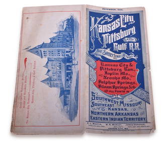
1895 Kansas City, Pittsburg & Gulf Railroad Public TimetableRail & Road Auctions4.6(165)See Sold PriceMar 08, 2024
A "Fly TWA to Walt Disney's Magic Kingdom" Brochure.Van Eaton Galleries4.6(103)See Sold PriceMar 02, 2024
An Indiana Jones Adventure Opening Year Field Map.Van Eaton Galleries4.6(103)See Sold PriceMar 02, 2024
A Disney's California Adventure Opening Day Map.Van Eaton Galleries4.6(103)See Sold PriceMar 02, 2024
A 1971 Walt Disney World Magic Kingdom Souvenir Map.Van Eaton Galleries4.6(103)See Sold PriceMar 02, 2024
William Simpson's Sketches at the Seat of War - Two Volumes with 81 Hand-colored LithographsTrillium Antique Prints & Rare Books4.5(33)See Sold PriceFeb 24, 2024
Wilson - Ivory-billed Woodpecker, Red-headed & Pileated Woodpeckers. 29Trillium Antique Prints & Rare Books4.5(33)See Sold PriceFeb 24, 2024
Wilson - Carolina Parrot & Flycatchers. 26Trillium Antique Prints & Rare Books4.5(33)See Sold PriceFeb 24, 2024
1855 NOTES ON CENTRAL AMERICA by E. G. Squier antique w/ MAPSJasper524.5(9.9k)See Sold PriceFeb 27, 2024
Tour of the Dutch East Indies, with exceptional platesPBA Galleries4.7(389)See Sold PriceMar 07, 2024
Africa inc. discoveries of Livingstone Barth Vogel Chadda Exp. SWANSTON 1860 mapJasper524.5(9.9k)See Sold PriceFeb 28, 2024
Rare 19thc Colton Map, Argentine Republic, Chile, Uruguay, PataguayConnoisseur Auctions3.9(337)See Sold PriceMar 16, 2024
Reprint From The Original Coltons Map 1855 No.30 Copyright 1967Rapid Estate Liquidators and Auction Gallery4.5(1.1k)See Sold PriceFeb 29, 2024