SoldWalker (J. & C.) - Walker's Map of the Great Westernshowing from London to Bristol, lithographed map, 150 x 760 mm., light offsetting, spotting and surface dirt, folding concertina style into contemporary cloth covered boards, with printed label attachSee Sold Price
Walker: Map of Western and Eastern Hemisphere, 1840Map: Western Hemisphere / Eastern Hemisphere Maker: J & C Walker Published: 1840 Publisher: Society for the Diffusion of Useful Knowledge / S.D.U.K Size: Quarto, 12.75 inches J & C Walker were a groupSee Sold Price
SoldJ & C Walker Map of England & Wales, 52 x 41 ins.J & C Walker divided coloured engraving, Map of England & Wales, The Grand Trigonometrical Survey, 1840, 52 x 41 ins. Original cloth cover.See Sold Price
SoldJ & C Walker Map of the County Palatine of DurhamJ & C Walker coloured engraving, Map of the County Palatine of Durham, 1840, 32 x 40 ins. canvas backed, slip case.See Sold Price
Western Australia (and) Van Diemen LandTitle/Content of Map: Western Australia (and) Van Diemen Land Cartographer: WALKER, J. & C. Date: 1833 Publisher: Baldwin & Cradock/S.D.U.K. Size: 12Height - 15Width Printed by E. Brain. Two maps evenSee Sold Price
SoldJ&C WALKER, MAP OF FLORIDA dated 1834 sight: 12"xJ&C WALKER, MAP OF FLORIDA dated 1834 sight: 12"x 16"See Sold Price
SDUK Map of Western Hemisphere, 1844Map: Untitled (Western Hemisphere) Maker: Society for the Diffusion of Useful Knowledge, Walker, J. & C. Date: 1844 Size: Folio, 10.8 inches high x 10.25 inches wide Unusual untitled SDUK map showingSee Sold Price
SoldGeological map.- Walker (J. & C.) A Geological Map ofGeological map.- Walker (John & Charles, publishers) A Geological Map of England and Wales, First edition, second state, 'showing also the Inland Navigation by means of Rivers & Canals, with their EleSee Sold Price
Untitled. [Western Hemisphere]Title/Content of Map: Untitled. [Western Hemisphere] Date Printed: 1844 Cartographer: WALKER, J. & C. Size: 10.8X10.25 Unusual untitled SDUK map showing the equator and continents above and below on pSee Sold Price
SoldIndia.- Allen & Co. (William H.) Map of the WesternIndia.- Allen & Co. (William H.) Map of the Western Provinces of Hindoostan, The Punjab, Rajpootana, Sinde, Kabool &c., large and impressive folding map by J. & C. Walker, including parts of AfghanistSee Sold Price
SoldJ & C Walker World Folding Map, laid on canvas andJ & C Walker World Folding Map, laid on canvas and framed, "To her most Gracious Majesty, Queen Victoria. This map of the world on mercator's projection is most respectfully dedicated by her devoted sSee Sold Price
SoldWalker (J & C) Map of the Peninsula of IndiaWalker (John & Charles) engravers. Map of the Peninsula of India, comprising the whole of the Madras Presidency, and portions of the adjacent territories of Bengal and Bombay,second edition, eSee Sold Price
Walker (J. & C.) Extra-Peloponnesian GreeceWalker (J. & C.) Map of Extra-Peloponnesian Greece, As it stood at the beginning of the Peloponnesian war, by K.O. Muller, engraved map with original hand-colouring in outline, 590 x 720mm.,See Sold Price
SoldANTIQUE FLORIDA MAP, J & C Walker, 20 x 16 inches,ANTIQUE FLORIDA MAP, J & C Walker, 20 x 16 inches, overall framed size 22 x 18 inchesSee Sold Price
SoldAfter J and C Walker Handcoloured Map of Hunts with plaAfter J and C Walker Handcoloured Map of Hunts with places of meeting of foxhounds Shows Mr Drake, Mr Phillips, Old Berkshire , Heythrop 15 1/4 x 12 3/4"See Sold Price
SoldMAPS - IMPERIAL CHINA. WALKER, J. & C. (engraversMAPS - IMPERIAL CHINA. WALKER, J. & C. (engravers) - BEBEROM, K. Gulfs of Pe-Chili & Liau-Tung and Northern Portions of the Yellow Sea; Chifu or Yenti Harbour ... [no. 1260]; Pei-Ho or Peking River,See Sold Price
SoldWalker (J. & C.) CambridgeshireWalker (J. & C.) Cambridgeshire,map extending from Lincolnshire to Suffolk, showing places of the Meeting of Foxhounds, lithographed map with original outline hand-colouring, 390 x 325mm., cenSee Sold Price
SoldWalker (J. & C.) A Geological Map of England, WaleWalker (J. & C.) A Geological Map of England, Wales, and Part of Scotland,with Geological and Mineralogical Section from Land's End to the German Ocean, and St. George's Channel to the GermanSee Sold Price
SoldEngland.- Walker (J. & C.) A Geological Map of England,NO RESERVE England.- Walker (J. & C.) A Geological Map of England, Wales and Part of Scotland, with 24 different geological strata identified by color, and cross-sections showing geological and mineraSee Sold Price
SoldJ AND C WALKER FOX HUNTING MAP OF SUFFOLKJ and C Walker Fox Hunting Map of Suffolk hand coloured engraved map dissected and backed onto linen 33 x 40cmSee Sold Price
SoldWalker (J. & C.) A Geological Map of England and Wales,Walker (J. & C.) A Geological Map of England and Wales, showing also the Inland Navigation by means of Rivers & Canals, with their Elevation in feet above the Sea, later issue, large folding hand-coloSee Sold Price
Walker: Antique Map of Asia Minor Antiqua, 1852Title/Content of Map: Asia Minor Antiqua Cartographer: WALKER, J. & C./WILLIAM HENRY FRANCIS PLATE Size: 12.25X15.25 "Published under the superintendence of the Society for the Diffusion of Useful KnoSee Sold Price
Walker: Map of Turkish Empire in Europe, 1843Map of The Turkish Empire in Europe and Asia With The Kingdom of Greece. Chapman & Hall/SDUK., Walker, J. & C. 1843-10-15. Good view of the Balkans and the southern regions of the Russian Empire as weSee Sold Price
Walker: Map of Eastern Islands Malay Archipelago 1852Title/Content of Map: Eastern Islands Or Malay Archipelago Cartographer: WALKER, J. & C. Size: 12.5X16 Map showing southern Siam, Archipelago Filipino, Celebes, Borneo, Sumatra and many other islands.See Sold Price
Great Western RY November 1, 1880 Public TimetableJM Hobby Supply and Railroad Artifact Auctions4.4(127)See Sold PriceFeb 24, 2024
LATE 17TH C. FRENCH MAP OF THE NEW WORLD BY ALEXIS-HUBERT JAILLOT (1632-1712)Thomaston Place Auction Galleries4.4(393)See Sold PriceFeb 24, 2024
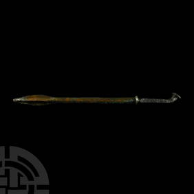
Western Asiatic Bronze Spearhead with Decorative Supports and Blood ChannelsTimeLine Auctions Ltd.4.6(183)See Sold PriceMar 07, 2024
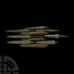
Western Asiatic Bronze Arrowheads, Javelin Heads and DaggersTimeLine Auctions Ltd.4.6(183)See Sold PriceMar 07, 2024
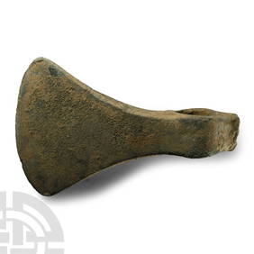
Large Western Asiatic Bronze Socketted AxeheadTimeLine Auctions Ltd.4.6(183)See Sold PriceMar 07, 2024
Numismatic Books - Whelan - The Numismatic Atlas of the Roman EmpireTimeLine Auctions Ltd.4.6(183)See Sold PriceMar 09, 2024
1960's Cleveland Indians Team Signed BaseballDana J. Tharp Auctions4.7(271)See Sold PriceFeb 24, 2024
Pair of Early Railroad Maps - 1874 Delaware, Lackawanna & Western and 1876 Pennsylvania RailroadRail & Road Auctions4.6(165)See Sold PriceMar 07, 2024
Adams & Westlake Chicago Great Western Railroad LanternRail & Road Auctions4.6(165)See Sold PriceMar 07, 2024
1873 and 1877 Atlantic & Great Western Railroad Annual PassesRail & Road Auctions4.6(165)See Sold PriceMar 08, 2024
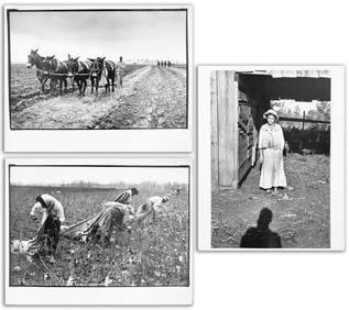
[BUSINESS -- WALKER, Madam C.J. (born Sarah Breedlove, 1867-1919)]. The Madam C.J. Walker BeautyFreeman's | Hindman4.4(1.6k)See Sold PriceFeb 27, 2024
COLLECTION OF COIN SILVER SPOONS.Amelia Jeffers, Auctioneers & Appraisers4.5(120)See Sold PriceMar 09, 2024
1764 Bellin Map of Western Guadeloupe in the Lesser Antilles -- Partie Occidentale de l'Isle de laJasper524.5(9.9k)See Sold PriceFeb 27, 2024
Tour of the Dutch East Indies, with exceptional platesPBA Galleries4.7(385)See Sold PriceMar 07, 2024
NORTH & WEST AFRICA. Gold Coast (Ghana) Slave Coast. Tribal names 1890 mapJasper524.5(9.9k)See Sold PriceFeb 28, 2024
Carl J. Sundevall (1801 - 1875) Set of 4 Bird Prints - Dove - Woodpecker - DuckProverde Auctions4.3(3)See Sold PriceFeb 28, 2024


![Untitled. [Western Hemisphere] (1 of 1)](https://p1.liveauctioneers.com/5584/120548/61369157_1_x.jpg?height=282&quality=70&version=1524013707)


![[BUSINESS -- WALKER, Madam C.J. (born Sarah Breedlove, 1867-1919)]. The Madam C.J. Walker Beauty (1 of 9)](https://p1.liveauctioneers.com/197/319238/171467936_1_x.jpg?height=282&quality=70&version=1708470653)