John Payne, "Universal Geography", 1796John Payne, "Universal Geography", 1796, the new edition in two volumes describing Asia, Africa Europe and America, including a variety of maps and hand colored copper plates, with toning on pages, teSee Sold Price
SoldPAYNE, JOHN. Universal Geography formed into aPAYNE, JOHN. Universal Geography formed into a New and Entire System. Hand-colored engraved frontispieces; 38 maps, each hand-colored in outline; 39 engraved plates; folding table. 2 volumes. Folio, 3See Sold Price
Sold18th Century World Geography Book18th Century World Geography Book Payne, John, "Universal Geography Formed Into a New and Entire System...as Connected With Geography; of the Planetary System to Which the Earth Belongs; and of the UnSee Sold Price
Sold1799 Payne/Low Map of "Tennassee"A Map of the Tennassee [sic] Government from the latest Surveys, 1799, by John Payne, published by E. Low, New York, 1799. From "A New and Complete Universal Geography" by John Payne. Copper plate engSee Sold Price
Georgia from the Latest Authorities 1799Title/Content of Map: Georgia from the Latest Authorities 1799 Date: 1799 Cartographer: SCOLES, I. Publisher: JOHN LOW Size: 7.75Height - 15.1Width From the "Universal Geography" of John Payne. GeorgiSee Sold Price
C 1799 Universal Geography Book by John PayneC 1799 Universal Geography Book by John Payne. 8.75 inches x 5.5 inches.See Sold Price
C 1799 Universal Geography Book by John PayneC 1799 Universal Geography Book by John Payne. 8.75 inches x 5.5 inches.See Sold Price
SoldA Map of the Tennassee [sic] Government from the latest"A Map of the Tennassee [sic] Government from the latest Surveys 1810" by John Payne for his New and Complete Universal Geography, Volume 4, America, published by E. Low, New York. Uncolored map of eaSee Sold Price
SoldAmerican-Published Early Map of SouthCarolina [The State of South Carolina, from the best Authorities, 1799,] by John Payne, from Payne's [New and Complete Universal Geography], published by J. Low, New York, 1799, noting topographical dSee Sold Price
Two Georgia MapsAmerican, 18th/19th century: "Georgia from the latest Authorities", by John Payne, published by John Low for Payne's [New and Complete Universal Geography,] New York, 1799, on laid paper, 8-1/4 x 15-1See Sold Price
SoldThe State of Pennsylvania from the Latest Surveys, 1800The State of Pennsylvania from the Latest Surveys, 1800 Published by John Low, New York From John Payne's "A New and Complete System of Universal Geography," published circa 1802. Medium: Original copSee Sold Price
SoldVermont from the Latest Authorities, 1799Vermont from the Latest Authorities, 1799 From John Payne's "A New and Complete System of Universal Geography", published circa 1802. Medium: Original copper engraved map Plate size: 9 inches high x 7See Sold Price
SoldMap; The State of Pennsylvania, 1800.Map; The State of Pennsylvania from the Latest Surveys 1800. Published by J. Low, NYork. This map is from John Payne's A New and Complete System of Universal Geography, published c1798-1800 per ListerSee Sold Price
SoldTenn. Map 1811, Payne/Low"A Map of the Tennassee [sic] Government from the latest Surveys 1810", by John Payne, published by E. Low, New York, 1811. From "A New and Complete Universal Geography", Vol. IV, by John Payne. CoppeSee Sold Price
SoldKentucky Map, 1800 Payne"The State of Kentucky with Adjoining Territories" Map, by John Payne, engraved by John Scoles, published by John Low, New York, 1800. From "A New and Complete System of Universal Geography" by John PSee Sold Price
MAP, South Carolina, PayneSouth Carolina. John Payne, The State of South Carolina from the Best Authorities, from A New and Complete Universal Geography, 1799 (dated). Hand Color. This early map of the state is finely engravedSee Sold Price
Payne's Geography Book IV, 1799New and Complete System of Universal Geography Describing Asia, Africa, Europe, and America; Book IV, by John Payne. Printed and sold by John Low, New York, 1799. 525 pages plus tables. Leather boundSee Sold Price
SoldThree Maps of PennsylvaniaThree Maps of Pennsylvania Including, PAYNE, John. The State of Pennsylvania from the Latest Surveys 1800. New York, 1800. From Payne's New & Complete System of Universal Geography, one of the earSee Sold Price
Payne's Geography Europe Asia Africa AmericaTitle: Universal Geography Formed into a New and Entire System; Describing Asia, Africa, Europe, and America...the History of Man...Arts, Sciences, Commerce... Author: Payne, John Description: 3 volumSee Sold Price
SoldPayne's Geography with maps of U.S. states 1798-1800Heading: Author: Payne, John Title: New and Complete System of Universal Geography; Describing Asia, Africa, Europe and America... Place Published: New York Publisher:John Low Date Published: </See Sold Price
Sold(2) ENGRAVED MAPS ASIA & WORLD MERCATOR PROJECTION(lot of 2) Framed engravings on paper, maps, including: (1) "General Chart on Mercator's Projection," engraved for Payn's [Payne's] "Universal Geography," published by Low & Willis, New York, sight: 7See Sold Price
Sold1799 Vermont from the latest authorites, published by J1799 Vermont from the latest authorites, published by J Low for Payne's Universal Geography, folds as issued, 10 by 8 inchesSee Sold Price
A View Of Fort Oswego On The Shore Of L. Ontario ...A View Of Fort Oswego On The Shore Of L. Ontario. 1799, T. Clarke, Sc. J Low, oval copper engraving 7.1 x 4.25 inches. From Payne's Universal Geography, 1799 4 vols. Please note that this lot has a coSee Sold Price
SoldTwo 18th Century Georgia MapsAmerican: "A Map of Georgia, also the Two Floridas, from the best Authorities", by Amos Doolittle, published in Jedidiah Morse's [American Universal Geography,] Thomas & Andrews, Boston, 1796, on laidSee Sold Price
Battle of the Nile: Disposition of the English & French Fleets, at the Commencement of the Action,Trillium Antique Prints & Rare Books4.5(30)See Sold PriceFeb 24, 2024
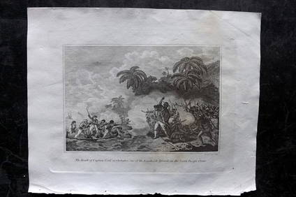
Cooke, George 1801 Print. Death of Captain Cook at Hawaii USAAlbion Auctions4.6(336)See Sold PriceMar 07, 2024
Cooke, George 1801 Print. Kaneena, Chief of the Sandwich Islands. HawaiiAlbion Auctions4.6(336)See Sold PriceMar 07, 2024
Cooke, George 1801 Print. Maori Tattoo Man, Warrior of New ZealandAlbion Auctions4.6(336)See Sold PriceMar 07, 2024
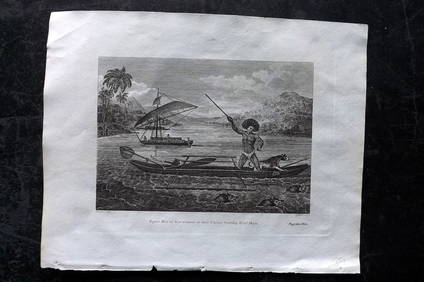
Cooke, George 1801 Print. Natives of Tahiti attacking Capt. WallisAlbion Auctions4.6(336)See Sold PriceMar 07, 2024
Cooke, George 1801 Print. Papua New Guinea Man hunting Wild HogsAlbion Auctions4.6(336)See Sold PriceMar 07, 2024
Cooke, George 1801 Print. Savage of New Caledonia, PacificAlbion Auctions4.6(336)See Sold PriceMar 07, 2024
Cooke, George 1801 Print. Savage of Nootka Sound, CanadaAlbion Auctions4.6(336)See Sold PriceMar 07, 2024
Cooke, George 1801 Print. Savage of Price William Sound, AlaskaAlbion Auctions4.6(336)See Sold PriceMar 07, 2024
Cooke, George 1801 Print. Woman of the Sandwich Islands. HawaiiAlbion Auctions4.6(336)See Sold PriceMar 07, 2024
Cooke, George 1801 Antique Map. United States of AmericaAlbion Auctions4.6(336)See Sold PriceMar 01, 2024
Cooke, George 1801 Antique Map. West Indies CaribbeanAlbion Auctions4.6(336)See Sold PriceMar 01, 2024
Cooke, George 1801 Antique Map. Italy, Sicily, Sardinia & CorsicaAlbion Auctions4.6(336)See Sold PriceMar 01, 2024
Stanford, Edward 1901 Large Map. Geological Map of the British IslesAlbion Auctions4.6(336)See Sold PriceMar 01, 2024


![A Map of the Tennassee [sic] Government from the latest (1 of 7)](https://p1.liveauctioneers.com/525/90540/46332609_1_x.jpg?height=282&quality=70&version=1467264089)