SoldAndriveau-Goujon (Eugene) - Carte Générale deswith 4 inset maps of Long Island, the Atlantic, the Lesser Antilles and Central America, engraved map with extensive original hand-colouring, 650 x 930mm., dissected and linen-backed, slight browningSee Sold Price
SoldAndriveau-Goujon (E) États UnisAndriveau-Goujon (Eugène) Carte Générale Des États Unis Et Du Méxique Comprenant L'Amérique Centrale Et Les Antilles,North America, with inset maps of central America, Long Island, and the AtlSee Sold Price
SoldAndriveau-Goujon (E) L'Asie OrientaleAndriveau-Goujon (Eugene) Carte de L'Asie Orientale comprenant L'Empire Chinois,Le Japon, Les Etats De L'Indo-Chine et Le Grand Archipel D'Asie De Malaisie, engraved folding map with hand-coloSee Sold Price
E. Andriveau-goujon - Carte Generale Des Etats, 1865E. Andriveau-goujon - Carte Generale Des Etats, 1865 Size: 44 X 30 1/2 In. - This Is A Gallery Stretched Giclee Print On Canvas. The Piece Was Printed On High Quality Artist Grade 350 Gsm, Acid-free,See Sold Price
E. ANDRIVEAU-GOUJON - CARTE GENERALE DES ETATS, 1865 -E. ANDRIVEAU-GOUJON - CARTE GENERALE DES ETATS, 1865 - Giclée on Canvas 36 x 25 in. - A Giclée Print Is The Highest Quality Print Available Today. Because There Is No Visible Dot Screen Pattern, TheSee Sold Price
E. ANDRIVEAU-GOUJON - CARTE GENERALE DES ETATS, 1E. Andriveau-Goujon - Carte Generale Des Etats, 1865 - Giclée On Canvas - 44 X 30 1/2 In. A Giclée Print Is The Highest Quality Print Available Today. Because There Is No Visible Dot Screen Pattern,See Sold Price
SoldE. ANDRIVEAU-GOUJON - CARTE GENERALE DES ETATS, 1E. Andriveau-Goujon - Carte Generale Des Etats, 1865 - Giclée On Canvas - 36 X 25 In.See Sold Price
E. Andriveau-goujon - Carte Generale Des Etats, 1865E. Andriveau-goujon - Carte Generale Des Etats, 1865 Size: 44 X 30 1/2 In. - This Is A Gallery Stretched Giclee Print On Canvas. The Piece Was Printed On High Quality Artist Grade 350 Gsm, Acid-free,See Sold Price
E. ANDRIVEAU-GOUJON -CARTE GENERALE DES ETATS, 1865 -E. Andriveau-goujon -carte Generale Des Etats, 1865 - Giclée On Canvas -40 X 27 3/4 In. - A Giclée Print Is The Highest Quality Print Available Today. Because There Is No Visible Dot Screen Pattern,See Sold Price
E. ANDRIVEAU-GOUJON - CARTE GENERALE DES ETATS, 1E. Andriveau-Goujon - Carte Generale Des Etats, 1865 - Giclée On Canvas - 36 X 25 In.See Sold Price
E. ANDRIVEAU-GOUJON - CARTE GENERALE DES ETATS,E. Andriveau-Goujon - Carte Generale Des Etats, 1865 - Giclée On Canvas - 40 X 27 3/4 In. A Giclée Print Is The Highest Quality Print Available Today. Because There Is No Visible Dot Screen Pattern,See Sold Price
SoldParis.- Andriveau-Goujon (J.) Carte Topographique DesParis.- Andriveau-Goujon (J.) Carte Topographique Des Environs de Paris, showing from Montfort-l'Amaury to Meaux, and Plailly to Arpajon, engraved map, with hand-colouring, 690 x 1000 mm. (27 1/8 x 39See Sold Price
SoldANDRIVEAU-GOUJON, E.; and VUILLEMIN, ALEXANDREANDRIVEAU-GOUJON, E.; and VUILLEMIN, ALEXANDRE. Carte Generale des Etats-Unis et du Mexique comprenant l'Amerique Centrale et les Antilles. Hand-colored engraved case map in 18 sections, 670x955 mm ovSee Sold Price
SoldCarte Genrale Des Etats-Unis Et Du Mexique 1862Map Title: Carte Genrale Des Etats-Unis Et Du Mexique Date: 1862 Publisher: Andriveau-Goujon: Paris Size: 24.3 x 18.25 inches Eastern sheet only. Only east of the Mississippi shown, only Yucatan shownSee Sold Price
1875 Carte Generale des Etats-Unis et du MexiqueThis is an authentic antique map of the United States and Mexico, with inserts of Central America and the Lesser Antilles by E. Andriveau-Goujon. The map came out of Paris and is dated 1875. This largSee Sold Price
SoldFrance C1840-75 Pair of Large Hand Colored Maps"Carte Compare la Gaule" Large Hand Coloured Steel Engraved Map Published C1875, Paris for "Atlas Universel" by Eugène Andriveau-Goujon. Together with one other by Goujon, "France Historique" From AtSee Sold Price
Eugène Andriveau GoujonEugène Andriveau Goujon, Plan géométral de Paris et des ses agrandissements... 1869 Incisione in acciaio suddivisa in 36 parti. Dimensioni totali: mm 1040x1560. Con titolo in alto al centro; iSee Sold Price
SoldAndriveau-Goujon, J.: Atlas de géographie moderneAndriveau-Goujon, J. Atlas de géographie moderne, contenant les cartes générales et particuliéres des principales divisions du globe. Gr.-folio. Mit 19 doppelblattgr. (1 eingef.) grenzkol. gest. KSee Sold Price
SoldANDRIVEAU-GOUJON, EUGENE. Atlas Classique et UANDRIVEAU-GOUJON, EUGENE. Atlas Classique et Universel de Geographie Ancienne et Moderne . . . Nouvelle Edition. 41 (of 43) engraved double-page or folding maps and plates (lacking the plates of waterSee Sold Price
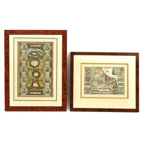
Andriveau-Goujon (Eugene) [Composit Atlas]Andriveau-Goujon (Eugene) [Composite Atlas], comprising 11 large engraved maps by Andriveau, Brue and Dufour, (of 15), as called for in manuscript index, mainly double-page, with original outlSee Sold Price
Sold2 19th c. mapsCartographers: Ferdinand G”tze (attributed), J. Andriveau-Goujon Title: [Map 1, Ferdinand G”tze (attributed)] Charte von Italien [in a set with Map 2, J. Andriveau-Goujon] Carte du Nord-Ouest de LSee Sold Price
SoldAndriveau-Goujon (E) Planisphere TerrestreAndriveau-Goujon (Eugene) Planisphere Terrestre, school map of the world, depicting the principle empires, with inset maps of the poles and mountain elevations, lithographic map, printed in coSee Sold Price
SoldAndriveau-Goujon (E) Planisphere TerrestreAndriveau-Goujon (Eugene) Planisphere Terrestre,the eastern and western hemispheres, with a section of the earth's crust below, engraved map with hand colouring, 810 x 1010mm., dissected and lSee Sold Price
1865 French antique terrestrial globe 14 " Andriveau-Goujon editeur1865 French antique terrestrial globe 14 " Andriveau-Goujon editeur Andriveau-Goujon Eugène Andriveau-Goujon (1832-1897) was active in Paris between 1858 and 1892.Little is known about EugènSee Sold Price
Eugène Delacroix (French, 1798-1863) - Groupe des Romains Illustres (Study for the Library ofFreeman's | Hindman4.5(158)See Sold PriceFeb 27, 2024
[MAPS]. DUFOUR, Auguste-Henri (1795-1865). Bound Volume of ...Potter & Potter Auctions4.6(545)See Sold PriceMar 07, 2024
Map of St. Kitts and Nevis Depot de la Marine, Paris, 1758Global Auctions Company4.3(36)See Sold PriceMar 03, 2024
Duval - Pair: Map of Georgia & Map of Moscow, RussiaTrillium Antique Prints & Rare Books4.5(32)See Sold PriceFeb 24, 2024
Duval - Pair: Map of India & Map of MaldivesTrillium Antique Prints & Rare Books4.5(32)See Sold PriceFeb 24, 2024
1758 MAP PARTIE DE LA MER GLACIALE contenants La Nouvelle Zemble RUSSIA antiqueJasper524.5(9.9k)See Sold PriceFeb 27, 2024
Railways & Transport.- [Prospectus] The Dorking, Brighton, and Arundel Atmospheric Railway, byForum Auctions4.3(53)See Sold PriceFeb 29, 2024
1764 Bellin Chart of Three South Haitian Bays -- Carte des Bayes du Mesle des Flamands et deJasper524.5(9.9k)See Sold PriceFeb 27, 2024
Carte de L'Algérie et de la Régence de Tunis' ANDRIVEAU-GOUJON Algeria 1850 mapJasper524.5(9.9k)See Sold PriceFeb 28, 2024
Rivières de Sanaga & Gambra'. Senegal Gambia rivers. Guinea. BELLIN 1746 mapJasper524.5(9.9k)See Sold PriceFeb 28, 2024
Eugene Atget Eug?ne Atget Magasin Avenue des Gobelins 1925Seized Assets Auctioneers4.3(602)See Sold PriceFeb 28, 2024


![Andriveau-Goujon (Eugene) [Composit Atlas] (1 of 1)](https://p1.liveauctioneers.com/410/3027/1300110_1_x.jpg?height=282&quality=70)


![[MAPS]. DUFOUR, Auguste-Henri (1795-1865). Bound Volume of ... (1 of 2)](https://p1.liveauctioneers.com/928/318880/171361279_1_x.jpg?height=282&quality=70&version=1707501302)


![Railways & Transport.- [Prospectus] The Dorking, Brighton, and Arundel Atmospheric Railway, by (1 of 1)](https://p1.liveauctioneers.com/5458/319736/171654703_1_x.jpg?height=282&quality=70&version=1708010439)


