SoldThree early Southern maps[A Sketch of the Cherokee Country], London, 1772, "Engraved for Rev. Mants History of the War in America By J. Lodge", red "New York Historical Society" oval imprint, 10-3/4 x 18 in., [reduced at bottSee Sold Price
SoldThree early 19th century U.S. mapsThree early 19th century U.S. maps: "Southern Provinces of the United States", John Thomson, 1815, inset Hudson River scene, 19-3/4 x 23-1/2 in. (sight); "Carte Generale des Etats-Unis", E. Mentelle aSee Sold Price
SoldA COLLECTION OF EARLY 1900s SOUTHERN RAILWAY MAPS ETCThirty-three items include brochures, maps and company correspondence. We happily provide seamless in-house packing and shipping services on nearly everything we sell.See Sold Price
SoldVintage 1890 Southern Pacific Railroad MapMaps“Along the Sunset Route”--Vintage 1890 Southern Pacific Railroad Map 1890, “Map of the Southern Pacific Company and Connections,” Choice Extremely Fine. Three-color, 9.5&rdSee Sold Price
SoldThree early mapsFrance, "Galliae Regni Potentiss: Nova Descriptio Ioanne Ioliveto Auctore," hand colored, text verso, paper reinforcing tape on fold crease and at top verso, scattered browning, original edges,14-3/4See Sold Price
SoldThree early maps of Arabia,all hand colored, one by Guillamo Ruscelli, "Tabula Asiae VI", published Venice, 1561-64, Italian text verso, creases and minor stains, 8-5/8 x 12-1/8"; 1618 by Petras Bertius, "A Description D'ArabieSee Sold Price
SoldTHREE EARLY MAPS OF THE RUSSIAN EMPIRETHREE EARLY MAPS OF THE RUSSIAN EMPIRE. Comprising three maps of the Russian Empire including Laurie and Whittle's 1794 map entitled "Map Of The European And Asiatic Parts Of The Russian Empire," imaSee Sold Price
SoldThree Early Maps of South Carolina/North Carolina1. Mid 18th century map titled "A New Map of Carolina by Robert Morden"; page taken from a book or publication "A Description of Carolina"; map size approximately 5" x 5"; page size 6 3/8"W, 8"H; 2. MSee Sold Price
SoldThree Early Maps of the Mouth of the MississippiGroup of Three Hand-Colored Engraved Maps of the Mouth of the Mississippi River from Pierre-Francois Xavier Charlevoix's Histoire et Description Generale de la Nouvelle France by Jacques-Nicolas BelliSee Sold Price
SoldThree Early Southern Side Chairsprobably Virginia and North Carolina, 19th century: one attributed to the Johnson family, chair makers of southern Virginia, all ladder-backs in mixed woods: oak split seat and baluster-turned posts,See Sold Price
Three early maps of North AmericaAmerique Septentrionale, par Fx (Francois) Delamarche, 1833. Suite du Cours du Fleuve de St. Laurent, Depuis Quebec jusqu'au Generale des Voyages. Echelle de Lieues communes de France.See Sold Price
SoldThree Early Maps & Guides for Normandy FranceExcellent lot of three early Normandy items to include a fold out early 20th c. Bicycle Map, an 1880 tour guide with small individual maps and an early 20th c. guide with map in back. The maps are inSee Sold Price
THREE EARLY MAPS. The two largest are hTHREE EARLY MAPS. The two largest are handcolored. Scandinavia, dated 1719. 21" x 25"; Ulster, sold by William Berry in London. 19 3/4" x 23". And a small engraved map of Yorkshire from a magazine. 8"See Sold Price
SoldTHREE MAPS HUNGARY & AMERICAN 1755-1873Three early maps, including: 1755 color map of Hungary, 21" x 18" (w/ margins 30" x 22 1/4"), J. Gibson, edgewear, tears, some separation at middle fold, some light staining / toning; 1873 b/w map ofSee Sold Price
SoldThree Early American Maps"Tennasee (sic) lately the S.Wn. Territory" from "Cary's American Pocket Atlas", Philadelphia, 1801, 8 x 6-1/2 in. (sight), matted with gilt painted frame, sun exposure at center fold; "Tennessee" MapSee Sold Price
SoldThree 1855 Southern maps"North Carolina", "Georgia" and "Mississippi", published by J. H. Colton and Company, 1855, each hand colored, about 17 x 13-1/2 in.; separately mounted in modern wood frames. Fading to colors, lightSee Sold Price
SoldThree early U.S. mapsThree early U.S. maps: "A Plan of the Country from Frogs Point to Croton River Showing the Positions of the American and British Armies from the 12th of October 1776 Until the Engagement on the WhiteSee Sold Price
SoldThree Early Engraved MapsThree early engraved maps, one dated 1790, largest 11 1/2" x 14 1/4" (sight), frame 15 1/2" x 18 1/2".See Sold Price
SoldThree Early German Maps of EuropeThree early European maps, created in Germany, depicting Deutschland (Germany) and Frankreich (France) and Europa (Europe) each measures approx. 16" x 12" ID all in matching framesSee Sold Price
Sold(3) Early Florida Maps, Bloomfield, Colton, 1880sThree early Florida maps including Bloomfield's Illustrated Historical Guide to St. Augustine, along with two copies of G.W. & C.B. Colton's New Sectional Map of the State of Florida. All circa 1880s.See Sold Price
Sold3 Southern Maps, incl. 2 Antonio Zatta 1778, SC 1796Three (3) Southern Maps, including two (2) Antonio Zatta 1778, one (1) South Carolina 1796. 1st-2nd items: Two (2) Antonio Zatta (Italian, fl. 1757-1797) maps of Virginia, Maryland, and the Carolinas,See Sold Price
Sold3 Early Maps of America, incl. Merian, De BryThree (3) early maps of America, including Merian and the Lost Colony of Roanoke. 1st item: "America Noviter Delineata" by Mathaus Merian (Swiss, 1593-1650), published in Frankfurt, 1638. Based on "ASee Sold Price
Sold3 Southern Maps, inc. Bellin, Tardieu, ZattaThree (3) Southern maps, including Bellin, Tardieu, and Zatta. 1st item: Carte de la Caroline et Georgie by Jacques Nicolas Bellin (French, 1703-1772) from Histoire Generale des Voyages by Antoine FraSee Sold Price
Three Southern Central Railroad Annual Passes - 1873, 1874, and 1878Rail & Road Auctions4.6(165)See Sold PriceMar 08, 2024
1977 JRR Tolkien 1st ed Silmarillion Lord of the Rings Middle Earth + MAPSchilb Antiquarian Rare Books4.8(422)See Sold PriceMar 31, 2024
[BASEBALL]. Group of Three Early Cuban Newspapers Related t...Potter & Potter Auctions4.6(544)See Sold PriceMar 07, 2024
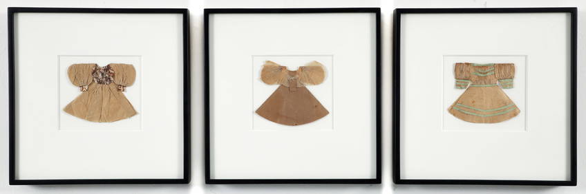
Set of Three Early 20th C. Pressed Paper DressesConcept Art Gallery4.7(509)See Sold PriceMar 06, 2024
Set of Three Early Triple Play Tables by Gaetano Pesce for Fish Design (1996)Jasper524.5(9.8k)See Sold PriceFeb 27, 2024
1764 Bellin Chart of Three South Haitian Bays -- Carte des Bayes du Mesle des Flamands et deJasper524.5(9.8k)See Sold PriceFeb 27, 2024
THREE EARLY 20TH CENTURY CHINESE FAMILLE ROSE PORCELAIN DISHES Late Qing/Republic, painted with figuHannam's Auctioneers Ltd4.3(391)See Sold PriceFeb 29, 2024
THREE EARLY 20TH CENTURY CHINESE FAMILLE ROSE PORCELAIN LANDSCAPE DISHES Late Qing/Republic, paintedHannam's Auctioneers Ltd4.3(391)See Sold PriceFeb 29, 2024
Southern Pacific Crew Pak & UP CoastersRapid Estate Liquidators and Auction Gallery4.5(1.1k)See Sold PriceMar 02, 2024


![[BASEBALL]. Group of Three Early Cuban Newspapers Related t... (1 of 3)](https://p1.liveauctioneers.com/928/318880/171361352_1_x.jpg?height=282&quality=70&version=1707501302)