Soldc. 1770, MAP OF CONNECTICUT AND RHODE ISLANDMapsc. 1770, “A NEW AND ACCURATE MAP OF CONNECTICUT AND RHODE ISLAND,” Choice Fine. Uncolored copperplate engraving, no date or maker, 10.25” x 13.5” image, plus margins, on fiSee Sold Price
SoldC. 1770 Rhode Island Or Eastern Connecticut HighboyC. 1770 Rhode Island Or Eastern Connecticut Highboy, 64 3/4" Lower CarcassSee Sold Price
SoldMap of Connecticut & Rhode Island 1776Title: A Map of Connecticut and Rhode Island, with Long Island Sound, &c. Author: Gentleman's Magazine Description: Copper-engraved map. 17x22.5 cm. (6¾x9"). Rhode Island and Connecticut at the beginSee Sold Price
SoldTwo 19th C. Maps of U.S. StatesLot of two mid-19th C. maps of Massachusetts, Rhode Island, and Connecticut. Various dates and publishers.See Sold Price
A map of Connecticut and Rhode Island with Long IslandTITLE/CONTENT OF MAP: 'A map of Connecticut and Rhode Island with Long Island Sound &c.' The top image on the right hand side shows the entire map. To view a close up of the map showing the level of pSee Sold Price
A map of Connecticut and Rhode Island with Long Island Sound. GENTS MAG 1776Title: A map of Connecticut and Rhode Island with Long Island Sound. GENTS MAG 1776 Description: A map of Connecticut and Rhode Island with Long Island Sound &c.' by Unattributed (1776). Antique coppeSee Sold Price
SoldThree 19th C. Maps of New England StatesLot of three 19th C. maps of New England states: Vermont/New Hampshire; Massachusetts; Massachusetts/Rhode Island/Connecticut. Various dates and publishers.See Sold Price
Connecticut and Rhode Island, 1776Title: A Map of Connecticut and Rhode Island, with Long Island Sound, &c. Author: Gentleman's Magazine Description: Copper-engraved map. 17x22.5 cm. (6¾x9").Rhode Island and Connecticut at the beginnSee Sold Price
SoldConnecticut and Rhode Island, 1776Title: A Map of Connecticut and Rhode Island, with Long Island Sound, &c. Author: Gentleman's Magazine Description: Copper-engraved map. 17x22.5 cm. (6¾x9").Rhode Island and Connecticut at the beginnSee Sold Price
Sold20th C. U.S. Geological Survey MapsGrouping of 74 early 20th C. U.S. Geological Survey maps of Pennsylvania, New Jersey, New York, Connecticut, Rhode Island, Massachusetts.See Sold Price
SoldFINLEY, MAP OF MASS, CONN, RI,ENGR W/HC,C.1826Artist: Finley, Title: Map of Massachusetts, Connecticut, and Rhode Island, Pub: A New American Atlas, Date: C.1826, Medium: Hand-colored engraving, Paper size: 21 x 17, Retail: $1400, Condition: FairSee Sold Price
Colton's Massachusetts Connecticut and Rhode Island.Title/Content of Map: Colton's Massachusetts Connecticut and Rhode Island. Publication Date: 1869 Cartographer: COLTON, GEORGE WOOLWORTH Publisher: G.W. & C.B. COLTON & CO. Description: Detailed map sSee Sold Price
SoldPAIR 18TH C NEW ENGLAND/MASSACHUSETTS MAPSPair 18th century New England / Massachusetts maps. Includes "A Map of the Province of Massachusetts Bay, and Colony of Rhode Island, with part of Connecticut, New Hampshire, and Vermont." marked in lSee Sold Price
Map of MA, RI & CT. C. 1902The National Publishing Company's Railroad, Post Office, Township and Country Map of Massachusetts, Rhode Island and Connecticut. 1902. Colored lithograph. Linen backed. ; 36" x 38"See Sold Price
Colton's Massachusetts Connecticut and Rhode Island.Title: Colton's Massachusetts Connecticut and Rhode Island. Prublication Date: 1869 Cartographer: COLTON, GEORGE WOOLWORTH Publisher: G.W. & C.B. COLTON & CO. Size: 17Height - 26Width Additional InforSee Sold Price
SoldAntique Map of Southern New England 1836Map of Massachusetts, Rhode Island and Connecticut published by A.F. Wilcox Middletown, CT, Light & Stearns Boston and C. Shepard New York and Providence and is dated 1836. Engraved by J. Wells New YoSee Sold Price
Sold1836 SOUTHERN MASSACHUSETTS WALL MAP By WILCOX:Map of Massachusetts, Rhode Island and Connecticut published by A.F. Wilcox Middletown, CT, Light & Stearns Boston and C. Shepard New York and Providence and is dated 1836. Engraved by J. Wells New YoSee Sold Price
Sold1836 A.F Wilcox New England Tri-State Engraved MapUnited States,1836Highly detailed map of Massachusetts, Rhode Island, and Connecticut. Engraved by J. Wells, New York, published by A.F. Wilcox Middletown, Connecticut; Light & Stearns, Boston; C. SheSee Sold Price
Map of New England States - 1850'sMap Maine, New Hampshire, Vermont, Massachusetts, Rhode Island and Connecticut Cartographer: George Woolworth Colton Dated: C 1850's Type: Engraved Hand ColoredSee Sold Price
Zatta, A. L Acadia, Le Provincie di SagadahookZatta, Antonio L'Acadia, Le Provincie di Sagadahook e Main. La Nuova Hampshire, La Rhode Island, e Part di Massachusset e Connecticut C. 1785 Copperplate engraving; outlined coloured Printed area: 43See Sold Price
SoldBradford: Antique Map Connecticut & Rhode Island, 1835Title/Content of Map: Connecticut & Rhode Island Date Printed: 1835 Cartographer: T. G. Bradford Material/Medium: Paper Size: 9 1/2" x13" A Comprehensive Atlas Geographical, Historical & Commercial. PSee Sold Price
SoldFramed Map of Connecticut, Rhode Island, & LongWilliams & Co. Custom Wooden Frame. Topographic map of Connecticut, Rhode Island, Long Island. Dimensions: 14x2 in L X 13.5x2 in W. good conditionSee Sold Price
SoldPilgrim Century Turned Ash Armchair, late 17th cA Pilgrim Century Turned Ash Armchair, late 17th c., Connecticut or Rhode Island, turned stiles flanking a spindle back, sloping arms and turned uprights, later rush seat, height 40 1/2 inSee Sold Price
Massachusetts Connecticut Rhode Island 1886Title/Content of Map: Massachusetts Connecticut Rhode Island 1886 Date Printed: 1886 Material/Medium: paper Size: approx. 19x13 inches Additional Info: The People's Unrivaled Family Atlas of the WorldSee Sold Price
LATE 17TH C. FRENCH MAP OF THE NEW WORLD BY ALEXIS-HUBERT JAILLOT (1632-1712)Thomaston Place Auction Galleries4.4(386)See Sold PriceFeb 24, 2024
1853 Colton's Railroad & Township Map of Massachusetts, Rhode Island, and ConnecticutRail & Road Auctions4.6(165)See Sold PriceMar 07, 2024
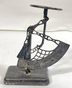
c1920 American Gorham Sterling Silver Postal ScaleHeritage Gallery Auctions4.4(56)See Sold PriceMar 10, 2024
Attributed Catherine Wright O/C Floral Still Life w/ VesselsHeritage Gallery Auctions4.4(56)See Sold PriceMar 10, 2024
1849 THE NEW-ENGLAND MERCANTILE UNIONNorth American Artifact Auctions4.6(182)See Sold PriceApr 20, 2024
Horace Burdick (MA,RI,CT,1844-1942) oil paintingBroward Auction Gallery4.8(277)See Sold PriceMay 05, 2024
EMILY BURLING WAITE (Massachusetts/Rhode Island/Washington, D.C./Europe, 1887-1980), Portrait of aEldred's4.7(409)See Sold PriceMar 13, 2024
1750 Bowen Map of Bermuda and St. Kitts -- A New & Accurate Map of Bermudas or Sommer's Islands...Jasper524.5(9.8k)See Sold PriceFeb 27, 2024
Partie Occidentale de l'Ancien Continent… W Africa Macaronesia. BONNE 1780 mapJasper524.5(9.8k)See Sold PriceFeb 28, 2024
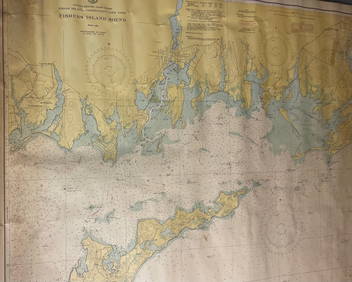
CHART: UNITED STATES - EAST COAST/ RHODE ISLAND - CONNECTICUT - NEW YORK/ Fishers IslandChurchill Galleries3.7(213)See Sold PriceFeb 26, 2024
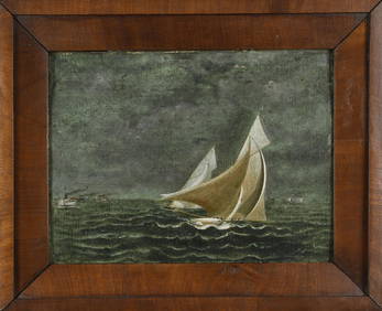
ANTIQUE AMERICAN SCHOOL OIL, RHODE ISLAND YACHT RACE.William Smith Auctions4.6(146)See Sold PriceMar 06, 2024