ATLAS of ANTIENT GEOGRAPHY by SAMUEL BUTLER 1843John McInnis Auctioneers,LLC4.5(505)See Sold PriceFeb 24, 2024
18TH C. ANTIQUE MAP: FRENCH & INDIAN WAR, FRAMEDThomaston Place Auction Galleries4.4(393)See Sold PriceFeb 24, 2024
Rand McNally Railroad Map Cabinet w/ 21 Railroad MapsRail & Road Auctions4.6(165)See Sold PriceMar 08, 2024
Keith Haring - Ink on New York Map, Best Buddies, Inscribed, Signed, and DatedSapphire Auction Gallery4(67)See Sold PriceMar 02, 2024
LATE 17TH C. FRENCH MAP OF THE NEW WORLD BY ALEXIS-HUBERT JAILLOT (1632-1712)Thomaston Place Auction Galleries4.4(393)See Sold PriceFeb 24, 2024
Central Railroad of New Jersey Map of Sandy Hook Route-ca. 1903JM Hobby Supply and Railroad Artifact Auctions4.4(127)See Sold PriceFeb 24, 2024
Lot of Six Mixed Atlas Box Cars-HO Scale-New in BoxJM Hobby Supply and Railroad Artifact Auctions4.4(127)See Sold PriceFeb 25, 2024
Rand McNally/Santa Fe Railroad Map of Iowa-1912JM Hobby Supply and Railroad Artifact Auctions4.4(127)See Sold PriceFeb 24, 2024
NICOLAES VISSCHER (NETHERLANDS, 1618-1709) MAP OF THE NEW WORLDThomaston Place Auction Galleries4.4(393)See Sold PriceFeb 24, 2024
17TH C. WORLD MAP BY NICOLAES VISSCHER (NETHERLANDS, 1618-1709)Thomaston Place Auction Galleries4.4(393)See Sold PriceFeb 24, 2024
Lot of Six Mixed Atlas Cabooses-HO Scale-New in BoxJM Hobby Supply and Railroad Artifact Auctions4.4(127)See Sold PriceFeb 25, 2024
ANCIENT BRITAIN. Anglo-Saxon Kingdoms. 'Heptarchie des Saxons'. MALLET 1683 mapTITLE OF THE MAP: 'Heptarchie des Saxons' (De L'Europe) England. Wales and parts of Scotland and of Ireland. DATE PRINTED: 1683 IMAGE SIZE: Approx Overall page size 13 x 21cm approximately (5 x 8 inchSee Sold Price
Mallet: Antique Map of Ancient Britain, 1683Title/Content of the Map: 'Heptarchie des Saxons' England. Wales and parts of Scotland and of Ireland. ANCIENT BRITAIN. Anglo-Saxon Kingdoms. Date Printed: 1683 Image Size: Approx Overall page size 13See Sold Price
Mallet: Antique Map of Ancient Britain, 1683Title/Content of Map: 'Heptarchie des Saxons' ANCIENT BRITAIN. Anglo-Saxon Kingdoms. England. Wales and parts of Scotland and of Ireland. Date Printed: 1683 Image Size: Approx Overall page size 13 x 2See Sold Price
Mallet: ANCIENT BRITAIN. Anglo-Saxon Kingdoms.TITLE OF THE MAP: 'Heptarchie des Saxons' England. Wales and parts of Scotland and of Ireland. DATE PRINTED: 1683 IMAGE SIZE: Approx Overall page size 13 x 21cm approximately (5 x 8 inches); image sizSee Sold Price
ANCIENT BRITAIN. Anglo-Saxon Kingdoms. 'Heptarchie desReserve Reduced! TITLE OF THE MAP: 'Heptarchie des Saxons' England. Wales and parts of Scotland and of Ireland. DATE PRINTED: 1683 IMAGE SIZE: Approx Overall page size 13 x 21cm approximately (5 x 8 iSee Sold Price
ANCIENT BRITAIN. Anglo-Saxon Kingdoms. 'Heptarchie desTITLE OF THE MAP: 'Heptarchie des Saxons' England. Wales and parts of Scotland and of Ireland. DATE PRINTED: 1683 IMAGE SIZE: Approx Overall page size 13 x 21cm approximately (5 x 8 inches); image sizSee Sold Price
1719 Mallet map of Saxon England and Wales -- Heptarchie des SaxonsTitle: 1719 Mallet map of Saxon England and Wales -- Heptarchie des Saxons Cartographer: A Mallet Year / Place: 1719, Frankfurt Map Dimension (in.): 5.9 X 3.8 in. This is a lovely smaller map of EnglaSee Sold Price
Sold1640 Blaeu Brittania Anglo-Saxonum Hand Colored MapComes with a certificate from Paulus Swaen Old Maps & Prints. Map depicts the ancient kingdoms of Britain, with 2 side panels. The left depicts the founders of the 7 Anglo-Saxon kingdoms, right showsSee Sold Price
Anglo-Saxon & Celtic Kingdoms 1897Title/Content of Map: Anglo-Saxon & Celtic Kingdoms 1897 Date Printed: 1897 Cartographer: I.S. Clare Material/Medium: paper Size: Approx. 12x14.5 inches Additional Info: Cram's Universal Atlas GeograpSee Sold Price
Anglo-Saxon & Celtic Kingdoms 1896Title/Content of Map: Anglo-Saxon & Celtic Kingdoms 1896 Date Printed: 1897 Cartographer: I.S. Clare Material/Medium: paper Size: Approx. 11x14.5 inches Cram's Universal Atlas Geographical, AstronomicSee Sold Price
Anglo-Saxon & Celtic Kingdoms 1896Title: Anglo-Saxon & Celtic Kingdoms 1896 Date Printed: 1897 Cartographer: I.S. Clare Materials: paper Dimensions: Approx. 11x14.5 inches Additional Info: Cram's Universal Atlas Geographical, AstronomSee Sold Price
Anglo-Saxon & Celtic Kingdoms 1896Title: Anglo-Saxon & Celtic Kingdoms 1896 Date Printed: 1897 Cartographer: I.S. Clare Material/Medium: paper Size/Dimensions: Approx. 11x14.5 inches Additional Information: Cram's Universal Atlas GeogSee Sold Price
SoldBlaeu: Antique Map of Anglo Saxon Britain, 1645Title/Content of Map: Map of Anglo Saxon Britian Date Printed: 1645 Cartographer: W. Blaeu Material/Medium: Paper Size: 19" x 23" Anglo Saxon Britian. Hand colored copperplate engraved. Latin text onSee Sold Price
SoldA mid 17th century map of Anglo Saxon Britain by BleauA mid 17th century map of Anglo Saxon Britain by Bleau, titled "Britannia prout divisa suit temporibus Anglo-Saxonum", the columns flanking the map with Dutch style scenes depicting the Saxon kingdomsSee Sold Price
Map of Anglo Saxon Britain. Print in 1850.Map of Anglo Saxon Britain 6oo years after Jesus Christ. Print in 1850.Print of steel engraving titled „Bretagne Anglo Saxonne Goo ans Jesus Christ.Author A. Houze.Engraved by unknown.From the „AtSee Sold Price
ANCIENT PERSIA (IRAN). and Empire of the Persians & Parthians. MALLET 1683 mapTITLE OF THE MAP: 'Empire des Perses at des Parthes; Ancienne Perse' (De L'Asie) Includes central and southwestern Asia & the Caspian sea DATE PRINTED: 1683 IMAGE SIZE: Approx Overall page size 13 x 2See Sold Price
Ancient ASSYRIAN EMPIRE Chaldea Mesopotamia Euphrates Asia Iraq. MALLET 1683 mapTITLE OF THE MAP: 'Empire des Assyriens; Assyrie Chaldee et Mesopatamie selon les anciens' (De L'Asie) DATE PRINTED: 1683 IMAGE SIZE: Approx Overall page size 13 x 21cm approximately (5 x 8 inches); iSee Sold Price
2ND KINGDOM OF BURGUNDY. 'Royaume de Bourgogne'. Lyon Rhone. MALLET 1683 mapTITLE OF THE MAP: 'Royaume de Bourgogne sous la seconde race des Roys de France' (De L'Europe) DATE PRINTED: 1683 IMAGE SIZE: Approx Overall page size 13 x 21cm approximately (5 x 8 inches); image sizSee Sold Price
1ST KINGDOM OF BURGUNDY. 'Royaume de Bourgogne'. Lake Geneva. MALLET 1683 mapTITLE OF THE MAP: 'Royaume de Bourgogne sous la race des Roys Bourguignons et sous la premiere Race des Roys de France' (De L'Europe) DATE PRINTED: 1683 IMAGE SIZE: Approx Overall page size 13 x 21cmSee Sold Price
SoldSpeede map of Anglo-Saxon Britain, [ca. 1610-1646[Britain]. John Speede. Britain As It Was Devided In The Tyme Of The Enlishe Saxons Especially During Their Heptarchy. Double-page engraved map of England, Wales, and Scotland. Lon: John Sudbury and GSee Sold Price
SoldMap of the Anglo-Saxon Heptarchy. By J.Speed. PublishedMap of the Anglo-Saxon Heptarchy. By J.Speed. Published London, 1612-1627 Copperplate Engraving in Later Hand Colour. "Britain As It Was Divided In The Tyme Of Englishe: Saxons" From: Theatre Of The ESee Sold Price
SoldMallet: Antique Map of Kingdom of Burgundy, 1683Title/Content of Map: 'Royaume de Bourgogne sous la seconde race des Roys de France' 2ND KINGDOM OF BURGUNDY, France CH Italy Date Printed: 1683 Image Size: Approx Overall page size 13 x 21cm approximSee Sold Price
SoldMallet: Antique Map of 2nd Kingdom of Burgundy, 1683Title/Content of Map: 'Royaume de Bourgogne sous la seconde race des Roys de France' 2ND KINGDOM OF BURGUNDY. Date Printed: 1683 Image Size: Approx Overall page size 13 x 21cm approximately (5 x 8 incSee Sold Price
Mallet: 1ST KINGDOM OF BURGUNDY. 'Royaume deTITLE OF THE MAP: 'Royaume de Bourgogne sous la race des Roys Bourguignons et sous la premiere Race des Roys de France' DATE PRINTED: 1683 IMAGE SIZE: Approx Overall page size 13 x 21cm approximatelySee Sold Price
LATE 18TH C. VERY LARGE CHART OF NORTHEAST CANADA BY DES BARRES (1721-1824), 1780, FRAMEDThomaston Place Auction Galleries4.4(393)See Sold PriceFeb 24, 2024
LATE 17TH C. FRENCH MAP OF THE NEW WORLD BY ALEXIS-HUBERT JAILLOT (1632-1712)Thomaston Place Auction Galleries4.4(393)See Sold PriceFeb 24, 2024
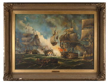
WILLIAM GRIFFIN (United Kingdom, 19th Century), "Battle of the Glorious 1st June"., Oil on canvas,Eldred's4.7(419)See Sold PriceFeb 27, 2024
Roman and Anglo-Saxon Bronze Brooch CollectionTimeLine Auctions Ltd.4.6(183)See Sold PriceMar 06, 2024
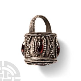
Pre Viking Scandinavian Silver Aroma Bucket Pendant with garnetsTimeLine Auctions Ltd.4.6(183)See Sold PriceMar 07, 2024
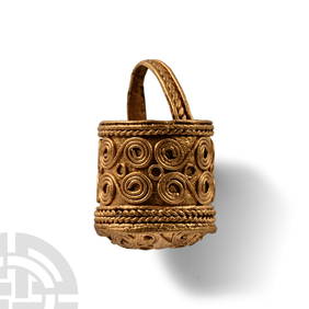
Pre Viking Scandinavian Gold Aroma Bucket PendantTimeLine Auctions Ltd.4.6(183)See Sold PriceMar 07, 2024
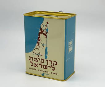
Jewish National Fund Collection Box - Great BritainLevy Auction House4.3(11)See Sold PriceFeb 27, 2024
Numismatic Books - Lindsay - A View of the Coinage of the Anglo-Saxon HeptarchyTimeLine Auctions Ltd.4.6(183)See Sold PriceMar 09, 2024
[MAPS]. DUFOUR, Auguste-Henri (1795-1865). Bound Volume of ...Potter & Potter Auctions4.6(545)See Sold PriceMar 07, 2024
Willem Blaeu, Etc. 17th C. Antiquarian Maps, 2Auctions at Showplace4.6(740)See Sold PriceMar 17, 2024
Duval - Pair: Map of India & Map of MaldivesTrillium Antique Prints & Rare Books4.5(32)See Sold PriceFeb 24, 2024
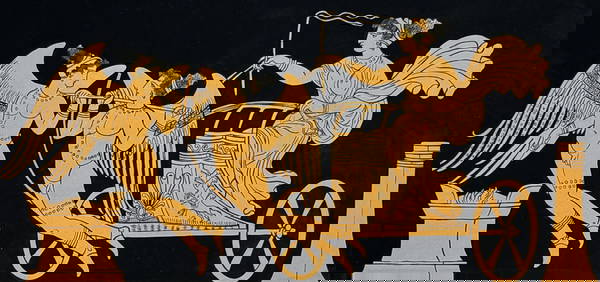
Hamilton - Engraving of a Painting from a Grecian Vase. 32Trillium Antique Prints & Rare Books4.5(32)See Sold PriceFeb 24, 2024
Hamilton - Engraving of a Painting from a Grecian Vase. 114Trillium Antique Prints & Rare Books4.5(32)See Sold PriceFeb 24, 2024
Hamilton - Engraving of a Painting from a Grecian Vase. 5Trillium Antique Prints & Rare Books4.5(32)See Sold PriceFeb 24, 2024
Books / Local Buckinghamshire History : Swanbourne - A History of an Anglo-Saxon Town by KenClaydon Auctioneers Ltd4.3(125)See Sold PriceFeb 26, 2024
Egyptian Steatite Scaraboid + Glazed Bead LenticularArtemis Fine Arts4.8(1.4k)See Sold PriceFeb 26, 2024
Egyptian Steatite Bead, Cowrie, Uraeus, Nefer, AnkhArtemis Fine Arts4.8(1.4k)See Sold PriceFeb 26, 2024
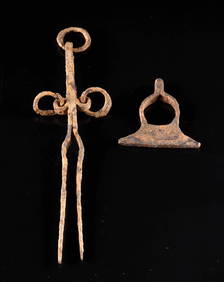
Anglo-Saxon / Viking Iron Fire Starter + Smithing ToolArtemis Fine Arts4.8(1.4k)See Sold PriceFeb 26, 2024


![[MAPS]. DUFOUR, Auguste-Henri (1795-1865). Bound Volume of ... (1 of 2)](https://p1.liveauctioneers.com/928/318880/171361279_1_x.jpg?height=282&quality=70&version=1707501302)