ATLAS of ANTIENT GEOGRAPHY by SAMUEL BUTLER 1843John McInnis Auctioneers,LLC4.6(502)See Sold PriceFeb 24, 2024
18TH C. ANTIQUE MAP: FRENCH & INDIAN WAR, FRAMEDThomaston Place Auction Galleries4.4(386)See Sold PriceFeb 24, 2024
Rand McNally Railroad Map Cabinet w/ 21 Railroad MapsRail & Road Auctions4.6(165)See Sold PriceMar 08, 2024
Keith Haring - Ink on New York Map, Best Buddies, Inscribed, Signed, and DatedSapphire Auction Gallery4(67)See Sold PriceMar 02, 2024
LATE 17TH C. FRENCH MAP OF THE NEW WORLD BY ALEXIS-HUBERT JAILLOT (1632-1712)Thomaston Place Auction Galleries4.4(386)See Sold PriceFeb 24, 2024
Central Railroad of New Jersey Map of Sandy Hook Route-ca. 1903JM Hobby Supply and Railroad Artifact Auctions4.4(126)See Sold PriceFeb 24, 2024
Lot of Six Mixed Atlas Box Cars-HO Scale-New in BoxJM Hobby Supply and Railroad Artifact Auctions4.4(126)See Sold PriceFeb 25, 2024
Rand McNally/Santa Fe Railroad Map of Iowa-1912JM Hobby Supply and Railroad Artifact Auctions4.4(126)See Sold PriceFeb 24, 2024
NICOLAES VISSCHER (NETHERLANDS, 1618-1709) MAP OF THE NEW WORLDThomaston Place Auction Galleries4.4(386)See Sold PriceFeb 24, 2024
17TH C. WORLD MAP BY NICOLAES VISSCHER (NETHERLANDS, 1618-1709)Thomaston Place Auction Galleries4.4(386)See Sold PriceFeb 24, 2024
Lot of Six Mixed Atlas Cabooses-HO Scale-New in BoxJM Hobby Supply and Railroad Artifact Auctions4.4(126)See Sold PriceFeb 25, 2024
BOKHARA KABUL & BALUCHISTAN. Afghanistan Khorassan Sinde Pakistan. SDUK 1846 mapTITLE/CONTENT OF MAP: 'BOKHARA, KABOOL AND BELOOCHISTAN.' DATE PRINTED: 1846 IMAGE SIZE: Approx 41.5 x 34.5cm, 16.25 x 13.5 inches (Large) TYPE: Antique steel engraved map with original outline hand cSee Sold Price
BOKHARA KABUL & BALUCHISTAN. Afghanistan Khorassan Sinde Pakistan. SDUK 1846 mapTITLE/CONTENT OF MAP: 'BOKHARA, KABOOL AND BELOOCHISTAN.' DATE PRINTED: 1846 IMAGE SIZE: Approx 41.5 x 34.5cm, 16.25 x 13.5 inches (Large) TYPE: Antique steel engraved map CONDITION: Good; suitable foSee Sold Price
BOKHARA KABUL & BALUCHISTAN. Afghanistan Khorassan Sinde Pakistan. SDUK 1846 mapTITLE/CONTENT OF MAP: 'BOKHARA, KABOOL AND BELOOCHISTAN.' DATE PRINTED: 1846 IMAGE SIZE: Approx 41.5 x 34.5cm, 16.25 x 13.5 inches (Large) TYPE: Antique steel engraved map with original outline hand cSee Sold Price
BOKHARA KABUL & BALUCHISTAN. Afghanistan Khorassan Pakistan Sinde. SDUK 1846 mapTITLE/CONTENT OF MAP: 'BOKHARA, KABOOL AND BELOOCHISTAN.' DATE PRINTED: 1846 IMAGE SIZE: Approx 41.5 x 34.5cm, 16.25 x 13.5 inches (Large) TYPE: Antique steel engraved map with original outline hand cSee Sold Price
BOKHARA KABUL & BALUCHISTAN. Afghanistan Khorassan Pakistan Sinde. SDUK 1846 mapTITLE/CONTENT OF MAP: 'BOKHARA, KABOOL AND BELOOCHISTAN.' DATE PRINTED: 1846 IMAGE SIZE: Approx 41.5 x 34.5cm, 16.25 x 13.5 inches (Large) TYPE: Antique steel engraved map with original outline hand cSee Sold Price
BOKHARA KABUL & BALUCHISTAN. Afghanistan Khorassan Sinde Pakistan. SDUK 1851 mapTITLE/CONTENT OF MAP: 'BOKHARA, KABOOL AND BELOOCHISTAN &c.' DATE PRINTED: 1851 IMAGE SIZE: Approx 41.5 x 34.5cm, 16.25 x 13.5 inches (Large) TYPE: Antique steel engraved map with original outline hanSee Sold Price
BOKHARA KABUL & BALUCHISTAN. Afghanistan Khorassan Sinde Pakistan. SDUK 1851 mapTITLE/CONTENT OF MAP: 'BOKHARA, KABOOL AND BELOOCHISTAN &c.' DATE PRINTED: 1851 IMAGE SIZE: Approx 41.5 x 34.5cm, 16.25 x 13.5 inches (Large) TYPE: Antique steel engraved map with original outline hanSee Sold Price
BUKHARA KABUL & BALUCHISTAN.Afghanistan Khorassan Sinde Pakistan.SDUK 1844 mapCAPTION PRINTED BELOW PICTURE: 'BOKHARA, CABOOL AND BELOOCHISTAN.' DATE PRINTED: This map was originally published by The Society for the Diffusion of Useful Knowledge in 1838; this date is printed onSee Sold Price
BUKHARA KABUL & BALUCHISTAN.Afghanistan Khorassan Sinde Pakistan.SDUK 1844 mapTITLE/CONTENT OF MAP: 'BOKHARA, CABOOL AND BELOOCHISTAN.' DATE PRINTED: This map was originally published by The Society for the Diffusion of Useful Knowledge in 1838; this date is printed on the map.See Sold Price
BOKHARA CABOOL & BALUCHISTAN Afghanistan Khorassan Sinde Pakistan SDUK 1844 mapTITLE/CONTENT OF MAP: 'BOKHARA, CABOOL AND BELOOCHISTAN.' DATE PRINTED: This map was originally published by The Society for the Diffusion of Useful Knowledge in 1838; this date is printed on the map.See Sold Price
BOKHARA CABOOL & BALUCHISTAN Afghanistan Khorassan Sinde Pakistan SDUK 1844 mapTITLE/CONTENT OF MAP: 'BOKHARA, CABOOL AND BELOOCHISTAN.' DATE PRINTED: This map was originally published by The Society for the Diffusion of Useful Knowledge in 1838; this date is printed on the map.See Sold Price
BOKHARA AFGHANISTAN & BALUCHISTAN. Sinde Pakistan. SDUK 1857 old antique mapTITLE/CONTENT OF MAP: 'BOKHARA, AFGHANISTAN, BELOOCHISTAN &c' DATE PRINTED: 1857 IMAGE SIZE: Approx 41.5 x 34.5cm, 16.25 x 13.5 inches (Large) TYPE: Antique steel engraved map with original hand colouSee Sold Price
BOKHARA AFGHANISTAN & BALUCHISTAN. Sinde Pakistan. SDUK 1857 old antique mapTITLE/CONTENT OF MAP: 'BOKHARA, AFGHANISTAN, BELOOCHISTAN &c' DATE PRINTED: 1857 IMAGE SIZE: Approx 41.5 x 34.5cm, 16.25 x 13.5 inches (Large) TYPE: Antique steel engraved map with original hand colouSee Sold Price
BOKHARA KABUL & BALUCHISTAN. Afghanistan KhorassanTITLE/CONTENT OF MAP: 'BOKHARA, KABOOL AND BELOOCHISTAN.' DATE PRINTED: 1846 IMAGE SIZE: Approx 41.5 x 34.5cm, 16.25 x 13.5 inches (Large) TYPE: Antique steel engraved map with original outline hand cSee Sold Price
SoldPAKISTAN Punjab Afghanistan Kashmir Sinde. Kabul. IndusTITLE/CONTENT OF MAP: 'THE PANJAB, AFGHANISTAN, KASHMEER, AND SINDE.' DATE PRINTED: 1874 IMAGE SIZE: Approx 42.5 x 34.5cm, 16.75 x 13.5 inches (Large) TYPE: Antique steel engraved map with original ouSee Sold Price
SoldWeller: Map of Afghanistan & Beloochistan, 1863Map: 'Afghanistan, Beloochistan, Pakistan. Kabul Karachi Quetta.' Date Printed: 1863 Image Size: Approx 43.5 x 31.0cm, 17.25 x 12.25 inches (Large) Type: Antique map with original outline colour CondiSee Sold Price
SoldAbraham Ortelius. Persici sive Sophorum Regni Typus,Abraham Ortelius. Persici sive Sophorum Regni Typus, engraved hand coloured map showing Iran, Afghanistan, Pakistan, the Caspian Sea and the north eastern tip of the Arabian Peninsula including UnitedSee Sold Price
SoldMap of Persia, Afghanistan, and BaluchistanTitle: Map of Persia, Afghanistan, and Baluchistan Rand, McNally & Co. Date: 1898 From New Standard Atlas of the World Indexed Size: 28.25 x 21.5 inches No Reserve: This lot starts at $1 and has no reSee Sold Price
Map of North AmericaNORTH AMERICA. Texas Republic. Mexican California. Russian America SDUK 1846 map Size: Approx 40.5 x 33.5cm, 16 x 13.25 inches (Large) Please note that this lot has a confidential reserve. When you leSee Sold Price
SDUK: Antique Map of Florida, 1846Title/Content of Map: 'NORTH AMERICA, XlV., Florida' showing Seminole Indian district & forts. Keys. Date Printed: 1846 Image Size: Approx 42.0 x 33.0cm, 16.5 x 13 inches (Large) Type: Antique steel eSee Sold Price
SDUK: Antique Map of Florida, 1846Title/Content of Map: 'NORTH AMERICA, XlV., Florida' showing Seminole Indian district & forts. Keys. Date Printed: 1846 Image Size: Approx 42.0 x 33.0cm, 16.5 x 13 inches (Large) Type: Antique steel eSee Sold Price
SDUK: Antique Map of Florida, 1846Title/Content of Map: 'NORTH AMERICA, XlV., Florida'. FLORIDA showing Seminole Indian district & forts. Keys. SDUK, 1846 antique map Date Printed: 1846 Image Size: Approx 42.0 x 33.0cm, 16.5 x 13 inchSee Sold Price
SoldTanner: Map of Persia and Arabia, 18361836 Tanner Map of Persia and Arabia. H S Tanner. 1836, Philadelphia. 11.5 x 14 in. An attractive and colorful map of the Arabian peninsula, Iraq, Iran and much of Afghanistan and Pakistan. The borderSee Sold Price
SoldSDUK: Antique Map of Southwestern USA, 1846CENTRAL AMERICA, SHEET II., INCLUDING TEXAS, CALIFORNIA AND THE NORTHERN STATES OF MEXICO' The map, published in 1846, shows the Republic of Texas as an independent state as it existed between 1836 anSee Sold Price
Two Michigan Central RR Annual Reports-June 1860 and December 31, 1897JM Hobby Supply and Railroad Artifact Auctions4.4(126)See Sold PriceFeb 24, 2024
Extremely early Ganesh from India, Afghanistan, or Pakistan.The Buddha Gallery4.4(29)See Sold PriceMar 13, 2024
PAKISTAN BOKHARA CARPET (8'10" x 12'10")Thomaston Place Auction Galleries4.4(386)See Sold PriceFeb 24, 2024
18TH C. ANTIQUE MAP: FRENCH & INDIAN WAR, FRAMEDThomaston Place Auction Galleries4.4(386)See Sold PriceFeb 24, 2024
Keith Haring - Ink on New York Map, Best Buddies, Inscribed, Signed, and DatedSapphire Auction Gallery4(67)See Sold PriceMar 02, 2024
Rand McNally Railroad Map Cabinet w/ 21 Railroad MapsRail & Road Auctions4.6(165)See Sold PriceMar 08, 2024
ANTIQUE JALDAR HAND KNOTTED WOOL RUG, 7.11 x 9.9 (241cm x 297cm)The Rug Life4.3(12)See Sold PriceMar 07, 2024
AFGHANI BALOUCH HAND KNOTTED RUG, NEW – 2.10 x 4.8 (86cm x 142cm)The Rug Life4.3(12)See Sold PriceMar 07, 2024
David Roberts - Obelisk of LuxorTrillium Antique Prints & Rare Books4.5(30)See Sold PriceFeb 24, 2024
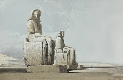
David Roberts - Approach of the Simoom, Desert of GizehTrillium Antique Prints & Rare Books4.5(30)See Sold PriceFeb 24, 2024
WEST AFRICA Explorers' routes Senegal Ashanti. Mountains of Kong. SDUK 1857 mapJasper524.5(9.8k)See Sold PriceFeb 28, 2024
NORTH AFRICA OF BABRBARY V Parts of Tripoli & Egypt. Libya Tribes. SDUK 1846 mapJasper524.5(9.8k)See Sold PriceFeb 28, 2024
OLD ILLUSTRATED 1902 CROSS-COVERED LANDS JOURNEY TO CALCUTTA, INDIA, 2 VOLUMESNY Elizabeth 4.3(84)See Sold PriceMar 03, 2024
ANTIQUE ILLUSTRATED HANDBOOK OF GEOGRAPHY AND TRAVEL IN ASIA, VOLUME 2, 1896NY Elizabeth 4.3(84)See Sold PriceMar 03, 2024