SoldGeorge IV's Mapseller Extraordinary! BeautifullyGeorge IV of England King George IV's Mapseller Extraordinary! Beautifully Hand-colored Ancient & Modern World Atlas Two early nineteenth-century world atlases prepared by Charles Smith (flourished 18See Sold Price
SoldMARVEL TALES #93 * CGC 4.5 * Early Atlas Horror * Pre-EC * Two Colan StoriesHeading: Author: Title: MARVEL TALES No. 93 Place Published: Publisher:Atlas [Indicia: Marvel Comics, Inc.] Date Published: 18111 Description: CGC certified:See Sold Price
SoldGrp: Mixed Atlas PagesLarge group of pages from a variety of early atlases. The majority are from two atlases: Mallet and "Della Geografia di Tolomeo." Maps from Mallet include including maps of Asia, eastern India, China,See Sold Price
SoldTwo early maps of the United States including Northern Two early maps of the United States including Northern Provinces & Southern Provinces - Drawn and engraved for Thomsons New General Atlas 1817. No. 56 & 57.See Sold Price
SoldTwo Early Maps of Poland,Matthaus Quad, Printed in Cologne, c.1592, detailed map of Southern Poland and the from the Weysel River in the north to the Carpathian Mountains in the south, centered on Auschwitz,Nicholas de Fer, PSee Sold Price
SoldLot of Two Early Maps.Includes 17th century Hand Colored Mariette Map of India and Indes Orientales 18" x 24" with huge margins and a Map of Arabia Deserta. 13 1/2" x 16" Black and White.See Sold Price
SoldTwo 16th century maps: Egypt and Africatwo early engraved maps in octavo format: 1) After Ptolemy, "Tabula Aphricae II" showing Libya, the North African shore, and Mediterranean islands, from the Universal Geography, Cologne, Keschedt, 159See Sold Price
SoldABRAHAM ORTELIUS MAP OF CYPRUS, 1573A hand colored wood engraving from Ortelisus' from 'Theatrum Orbis Therrarum' an early atlas of the world. Title Cypri Insulae Nova Desrcipt 1573. Being the center fold of two pages from the atlas theSee Sold Price
Sold2 British Possessions Caribbean & Atlantic Maps, 1746Two colorful, early maps of British possessions in the Caribbean and the Atlantic on one sheet from le Rouge's Introduction a La Geographie. The upper map depicts Jamaica divided into parishes, with aSee Sold Price
SoldTwo Small Framed Early Mapsincluding Connecticut and Virginia. Not examined out of frames. Largest frame size: 11 1/3" high, 13 3/4" wide. Stains, toning, creases. Provenance: Property of a Madison, CT Collector. VirSee Sold Price
SoldScarce 1882 RR map of New JerseyScarce map of New Jersey from the first mass-produced world atlas by George F. Cram. He published at least two versions of his 1883 Universal Family Atlas, an early edition and a later edition. The eaSee Sold Price
SoldWeber Costello Atlas World Globe on Bronze StandEarly 20th century two part form. Neoclassical styled bronze stand with three raised paw feet. Warm aged patina. Signed MADE BY WEBER COSTELLO CO CHICAGO HEIGHTS ILLINOIS. Good estate fresh condition.See Sold Price
SoldAN EARLY 19TH C SILVER ATLAS FIGURAL HOT WATER URNThe ball shape Sheffield plate kettle with orb form finial having matching bands of basketweave design, two ring handles and faucet all supported by a kneeling male figure as with Atlas, upon a squareSee Sold Price
SoldA RENAISSANCE REVIVAL WOODEN COMMODE, EARLY 20THA RENAISSANCE REVIVAL WOODEN COMMODE, EARLY 20TH CENTURY rectangular, on four feet, of which two are spreading, carved throughout with acanthus leaves, the front with three atlas figures separated bySee Sold Price
Sold(3) Early Florida Maps, Bloomfield, Colton, 1880sThree early Florida maps including Bloomfield's Illustrated Historical Guide to St. Augustine, along with two copies of G.W. & C.B. Colton's New Sectional Map of the State of Florida. All circa 1880s.See Sold Price
Sold2 Maps: Early U.S. plus Louisiana and a Polar Map, 19thTwo framed maps, 19th century. One oak framed map of United States east of the Mississippi and Louisiana and one gilt wood framed map of the polar regions.(SBAR2375/2) {PR} Measurements: Oak frame isSee Sold Price
Sold(3) EARLY MAPS and a PRINT AFTER WILLIAM BLAKEIncluding: 1886 Fulton's Territory of Alaska, Hawaiian Group or Sandwich Islands, New Zealand, Feejee Islands, 1867 "The World in Two Hemispheres" by Mitchell (colored) and "The Day of Judgement" prinSee Sold Price
SoldEARLY AMERICAN SCIENCE TRAVELSTwo large folio works combining modern scholarship, brilliant printing, and superb color reproductions, namely: BARTRAM, William. Botanical and Zoological Drawings, 1756-1788, reproduced from the FothSee Sold Price
SoldEARLY FRENCH MAPS OF VIRGINIA AND MARYLAND, LOT OF TWOEARLY FRENCH MAPS OF VIRGINIA AND MARYLAND, LOT OF TWO hand-colored, the first captioned "der Jungfrauen Landt / Fig. 15", with title in upper proper right corner "VIRGINIE", showing the Chesapeake BaSee Sold Price
SoldRARE EARLY MAP OF AMERICAS WITH LATER NOTATION -RARE EARLY MAP OF AMERICAS WITH LATER NOTATION - "Americae, nova Tabula" by Willem Janszoon Blaeu, Amsterdam, circa 1650, hand colored engraving on two joined sheets, printed prior to the 1700 editionSee Sold Price
SoldTwo hand colored two part maps of Rockefellerland toTwo hand colored two part maps of Rockefellerland to include Pocantico Hills New York, Westchester County and Area for Early Action. 45" x 39 1/2" each Provenance: Estate of Peggy & David RockefellerSee Sold Price
SoldEarly 1900's Chicago, Illinois, Ohio Indiana Ninthc. 1908 Ninth Division Railway Mail Service fold out map, showing Chicago, Illinois, Indiana, Ohio, Michigan, Wisconsin & part of Ontario. Handcolored on thin paper. 26" W X 28" L. * two tears to theSee Sold Price
Sold"A Map of Old Philadelphia…..", 1932"A Map of Old Philadelphia on which are indicated Buildings of Architectural Interest that were built during the 18th and early 19th Centuries and are still standing AD 1932, Two Hundred and Fifty YeaSee Sold Price
SoldThrough the Dark Continent by Stanley 1879 w/ MapsThis is a RARE early edition of "Through the Dark Continent" by Henry M. Stanley and published in 1879. This complete set consists of two hardbound volumes with a folding map in the rear pocket of eacSee Sold Price
EARLY 18TH C. DUTCH CHART OF PACIFIC OCEAN BY FREDERIK DE WIT (1629-1706) WITH CALIFORNIA AS ANThomaston Place Auction Galleries4.4(386)See Sold PriceFeb 24, 2024
LARGE EARLY 18TH C. DUTCH CHART OF UPPER NORTH AMERICA, PIERRE MORTIER (1661-1711), FRAMEDThomaston Place Auction Galleries4.4(386)See Sold PriceFeb 24, 2024
[JAPANESE BASEBALL]. Group of Two Early Score Cards and One...Potter & Potter Auctions4.6(539)See Sold PriceMar 07, 2024
Two Early 19th C. German Pewter Chargers, I.B. FINCK BLOCKZINNRivich Auction4.5(229)See Sold PriceMar 03, 2024
GERMAN - TWO EARLY 20th CENTURY 835 SILVER CANDELABRA, MUSUEM QUALITY, EXCELLENT CONDITION !!Jasper524.5(9.8k)See Sold PriceFeb 27, 2024
Two Early Staffordshire Toby Jug PitchersBroken Arch Auction Gallery NCFL#93994.6(294)See Sold PriceMar 04, 2024
TWO EARLY NORTH AMERICAN INUIT CARVED STONE TOGGLES OR PENDANTS one formed as a male, one formed asHannam's Auctioneers Ltd4.3(386)See Sold PriceFeb 27, 2024
Two Early 20th Century Watch / Fob Chains. Both Hallmarked Birmingham. 1 by William WalterHannam's Auctioneers Ltd4.3(386)See Sold PriceFeb 28, 2024
TWO EARLY 20TH CENTURY CHINESE PORCELAIN FIGURAL PANELS Late Qing/Republic. Largest 40 cm x 28 cm. (Hannam's Auctioneers Ltd4.3(386)See Sold PriceFeb 29, 2024
Two early carved Oak panels decorated with Lions and fruit 111 x 13 cm.Hannam's Auctioneers Ltd4.3(386)See Sold PriceMar 01, 2024
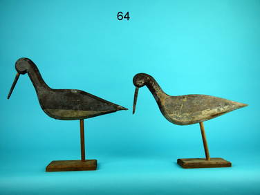
TWO EARLY SHOREBIRDS, SOUTH JERSEYFrank and Frank Sporting Collectibles LLC4.7(166)See Sold PriceMar 10, 2024


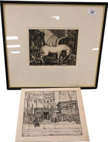
![[JAPANESE BASEBALL]. Group of Two Early Score Cards and One... (1 of 3)](https://p1.liveauctioneers.com/928/318880/171361461_1_x.jpg?height=282&quality=70&version=1707501302)