ATLAS of ANTIENT GEOGRAPHY by SAMUEL BUTLER 1843John McInnis Auctioneers,LLC4.5(505)See Sold PriceFeb 24, 2024
18TH C. ANTIQUE MAP: FRENCH & INDIAN WAR, FRAMEDThomaston Place Auction Galleries4.4(393)See Sold PriceFeb 24, 2024
Rand McNally Railroad Map Cabinet w/ 21 Railroad MapsRail & Road Auctions4.6(165)See Sold PriceMar 08, 2024
Keith Haring - Ink on New York Map, Best Buddies, Inscribed, Signed, and DatedSapphire Auction Gallery4(67)See Sold PriceMar 02, 2024
LATE 17TH C. FRENCH MAP OF THE NEW WORLD BY ALEXIS-HUBERT JAILLOT (1632-1712)Thomaston Place Auction Galleries4.4(393)See Sold PriceFeb 24, 2024
Central Railroad of New Jersey Map of Sandy Hook Route-ca. 1903JM Hobby Supply and Railroad Artifact Auctions4.4(127)See Sold PriceFeb 24, 2024
Lot of Six Mixed Atlas Box Cars-HO Scale-New in BoxJM Hobby Supply and Railroad Artifact Auctions4.4(127)See Sold PriceFeb 25, 2024
Rand McNally/Santa Fe Railroad Map of Iowa-1912JM Hobby Supply and Railroad Artifact Auctions4.4(127)See Sold PriceFeb 24, 2024
NICOLAES VISSCHER (NETHERLANDS, 1618-1709) MAP OF THE NEW WORLDThomaston Place Auction Galleries4.4(393)See Sold PriceFeb 24, 2024
17TH C. WORLD MAP BY NICOLAES VISSCHER (NETHERLANDS, 1618-1709)Thomaston Place Auction Galleries4.4(393)See Sold PriceFeb 24, 2024
Lot of Six Mixed Atlas Cabooses-HO Scale-New in BoxJM Hobby Supply and Railroad Artifact Auctions4.4(127)See Sold PriceFeb 25, 2024
CHAMPAGNE VINS/WINE MAP Carte Générale showing vineyards vignobles. LARMAT 1944Title: CHAMPAGNE VINS/WINE MAP Carte Générale showing vineyards vignobles. LARMAT 1944 Description: "Les Vins de Champagne"' (Atlas de la France Vinicole L. Larmat) by Louis Larmat (1944). VSee Sold Price
CHAMPAGNE VINS/WINE MAP Carte Générale showing vineyards vignobles. LARMAT 1944Title: CHAMPAGNE VINS/WINE MAP Carte Générale showing vineyards vignobles. LARMAT 1944 Description: "Les Vins de Champagne"' (Atlas de la France Vinicole L. Larmat) by Louis Larmat (1944). VSee Sold Price
CHAMPAGNE WINE/VINS MAP Carte Générale showingTITLE/CONTENT OF MAP: ' "Les Vins de Champagne"' This large map of the Champagne wine growing region includes the limits of the wine growing areas, and (in red) the vineyards/vignobles. The Montagne dSee Sold Price
CHAMPAGNE VINEYARD MAP Vallée de la Marne. Ay Mareuil Dizy-Magenta. LARMAT 1944Title: CHAMPAGNE VINEYARD MAP Vallée de la Marne. Ay Mareuil Dizy-Magenta. LARMAT 1944 Description: "Les Vins de Champagne" - Vallée de la Marne' (Atlas de la France Vinicole L. Larmat) by LSee Sold Price
CHAMPAGNE VINEYARD MAP La Côte des Blancs. Cramant Avize Oger Mesnil LARMAT 1944Title: CHAMPAGNE VINEYARD MAP La Côte des Blancs. Cramant Avize Oger Mesnil LARMAT 1944 Description: "Les Vins de Champagne" - La Côte des Blancs' (Atlas de la France Vinicole L. Larmat) bySee Sold Price
CHAMPAGNE VINEYARD MAP La Côte des Blancs. Cramant Avize Oger. Mumm. LARMAT 1944Title: CHAMPAGNE VINEYARD MAP La Côte des Blancs. Cramant Avize Oger. Mumm. LARMAT 1944 Description: "Les Vins de Champagne" - La Côte des Blancs' (Atlas de la France Vinicole L. Larmat) bySee Sold Price
CHAMPAGNE VINEYARD MAP Vallée de la Marne. Ay Mareuil. Mumm. LARMAT 1944Title: CHAMPAGNE VINEYARD MAP Vallée de la Marne. Ay Mareuil. Mumm. LARMAT 1944 Description: "Les Vins de Champagne" - Vallée de la Marne' (Atlas de la France Vinicole L. Larmat) by Louis LaSee Sold Price
CHAMPAGNE VINEYARD MAP La Côte des Blancs. Cramant Oger Avize Mesnil LARMAT 1944Title: CHAMPAGNE VINEYARD MAP La Côte des Blancs. Cramant Oger Avize Mesnil LARMAT 1944 Description: "Les Vins de Champagne" - La Côte des Blancs' (Atlas de la France Vinicole L. Larmat) bySee Sold Price
CHAMPAGNE VINEYARD MAP Montagne de Reims. Éperon de Bouzy. Mailly. LARMAT 1944Title: CHAMPAGNE VINEYARD MAP Montagne de Reims. Éperon de Bouzy. Mailly. LARMAT 1944 Description: "Les Vins de Champagne" - Montagne de Reims - Éperon de Bouzy' (Atlas de la France VinicoleSee Sold Price
COGNAC BRANDY MAP Crus. Carte Générale. Champagne/Bois &c. Charente. LARMAT 1947Title: COGNAC BRANDY MAP Crus. Carte Générale. Champagne/Bois &c. Charente. LARMAT 1947 Description: "Les Eaux-de-vie de France" - Carte Générale - "Le Cognac"' (Atlas de la FranceSee Sold Price
Larmat; CHAMPAGNE VINEYARD MAP Montagne de ReimsTITLE/CONTENT OF MAP: ' "Les Vins de Champagne" - Montagne de Reims & Vallée de l'Ardre. Vignobles d'Écueil, Sacy, Villedommange, Les Mesneux' This detailed map shows the communes and Champagne vineSee Sold Price
SoldPierre Mortier World MapPierre Mortier World Map, Carte Generale de Toute les Costes du Monde et les pays Norwellemat Decouvat (1700's). Medium: Hand-colored engraving. Size: 32" x 44.5" (frame); 23.5" x 36" (sight). ProvenaSee Sold Price
Sold2 antique maps, Northeast, & Arctic, includes "Carte2 antique maps, Northeast, & Arctic, includes "Carte Generale des Découvertes de l'Amiral de Fonte et autres Navigateurs Espagnols, Anglois et Russes pour la recherche du Passage a la Mer du Sud.See Sold Price
SoldNolin Map of the World 1789Jean-Baptiste Nolin (1686-1762), "Mappe-Monde ou Carte Generale de la Terre et des Mers, Suivant les Dernieres Observations," Paris: Mondhare, 1789. This hand colored map depicts the world in two hemiSee Sold Price
SoldCarte de l'Ocean Occidental DresseeMap: Carte de l'Ocean Occidental Dressee pour Servir a l'Histoire Generale des Voyages, 1746 Maker: J Bellin Date: 1746, Paris Description: This is a fantastic map of the North Atlantic. It is centereSee Sold Price
Bellin: Antique Map of Southern Philippines, 1758Title/Content of Map: 'Carte des Isles Philippines dressée sur la carte Espagnole du R.P. Murillo de Velarde 2e Feuille Pour servir à l'Histoire Générale des Voyages par le Sr. Bellin Ingr. de laSee Sold Price
SoldFramed Burgundy Cote De Nuit Vineyards MapFramed ATLAS DES GRANDS VIGNOBLES DE BOURGOGNE ‘Cote de Nuit’ topographic Map. Image includes detailed information about various vineyards along Cote de Nuit in Burgundy France. Map designed by SySee Sold Price
SoldRare c1780s U. S. map showing FrankliniaRare and unusual map of the United States showing early borders of various states. The seller has not been able to locate another copy of this map. The map appears to either be a source for, or copy oSee Sold Price
SoldFramed Map Showing World Time And CurrencyUnique rendering of the world map showing variation in world time when 12 noon at Greenwich. Greenwhich time has Clock face in relief, Foreign money corresponding roughly with a shilling lines the perSee Sold Price
SoldPalairet / Kitchin: Map of English/French North AmericaMap: Carte des Possessions Angloises & Francoises du Continent de l'Amerique Septentrionale Cartographer: J. Palairet / Kitchin Place & Date: London / 1756 Size: 22 3/4" x 17" Condition: beautifully cSee Sold Price
SoldSOUTHERN STATES TRADE ROUTE MAPLarge Framed Trade Route Map showing waterways and towns from the Mississippi River to Charles Town. Geographic Area Covered: Southern States, South Carolina,Santee River Valley, Savannah River ValleySee Sold Price
SoldBellin: Antique Map of Chesapeake Bay, 1757Map: Carte de la Baye de Chesapeack et Pays Voisins Cartographer: Bellin Place & Date: Paris / 1757/1760 Size: 11 1/8" x 7 3/8" Condition: b&w; overall age toning; some minor spotting; a tiny repairedSee Sold Price
SoldCOOPER RIVER PLANTATIONS 1932 MAP STONEYFramed Vintage Hand Colored Map showing the Plantations along the Cooper River as they were in 1842. Inset features information about the steamboat departure. Drawn by A.T.S. Stoney (Augustine ThomasSee Sold Price
SoldBellin: Antique Map of Gulf of Mexico & Caribbean, 1749Map: Carte Reduite du Golphe du Mexique et des Isles de l'Amerique Cartographer: Bellin Place & Date: Paris / 1749 Size: 32 1/4" x 21 1/8" Condition: outline color (cartouche uncolored); water stainsSee Sold Price
LARGE Robert Waltsak (NJ,b 1944) oil paintingBroward Auction Gallery4.7(292)See Sold PriceMar 10, 2024
LARGE Robert Waltsak (NJ,b 1944) oil paintingBroward Auction Gallery4.7(292)See Sold PriceMar 10, 2024
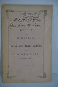
Boston and Maine RR Annual Report-September 12, 1849JM Hobby Supply and Railroad Artifact Auctions4.4(127)See Sold PriceFeb 24, 2024
Lake Superior and Mississippi River RR 1869 Seven Percent Bonds Book/Report-1869JM Hobby Supply and Railroad Artifact Auctions4.4(127)See Sold PriceFeb 24, 2024
Crams Railroad Map of New York-1881JM Hobby Supply and Railroad Artifact Auctions4.4(127)See Sold PriceFeb 24, 2024
Union Pacific RR Across The Continent West From Omaha, NE Book-April 2, 1868JM Hobby Supply and Railroad Artifact Auctions4.4(127)See Sold PriceFeb 24, 2024
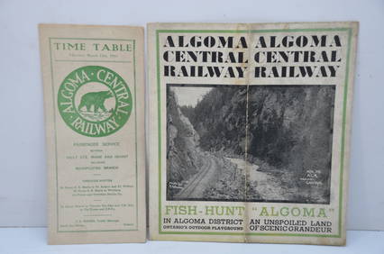
Algoma Central RY March 12, 1944 Public Timetable and BrochureJM Hobby Supply and Railroad Artifact Auctions4.4(127)See Sold PriceFeb 24, 2024
Vintage County Map Of NY State Plate EngravingThe Benefit Shop Foundation Inc.4.3(2.9k)See Sold PriceFeb 28, 2024
Group of New York Central Railroad Paper - Rule Books, Employee Timetables, Stationary, Log Books,Rail & Road Auctions4.6(165)See Sold PriceMar 07, 2024
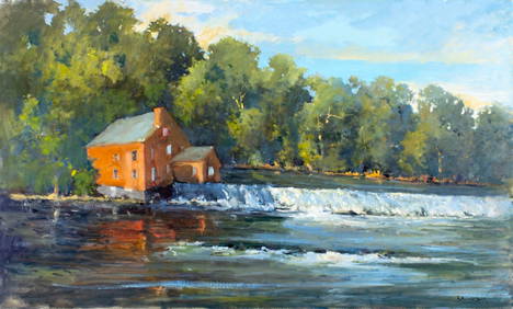
ANDREW RAYMOND JANSON OIL ON BOARD ADIRONDACKSCharleston Estate Services Ltd.4.5(69)See Sold PriceMar 03, 2024
Two (2) Antique 18th C. Copper Engraved Framed Maps - America & EuropeMagnusson Art Group4.5(53)See Sold PriceMar 14, 2024
Carey, pub. 1796 - Map of KentuckyTrillium Antique Prints & Rare Books4.5(32)See Sold PriceFeb 24, 2024
Carey, pub. 1796 - Map of the Tennassee State formerly part of North Carolina (Tennessee)Trillium Antique Prints & Rare Books4.5(32)See Sold PriceFeb 24, 2024