ATLAS of ANTIENT GEOGRAPHY by SAMUEL BUTLER 1843John McInnis Auctioneers,LLC4.6(504)See Sold PriceFeb 24, 2024
18TH C. ANTIQUE MAP: FRENCH & INDIAN WAR, FRAMEDThomaston Place Auction Galleries4.4(389)See Sold PriceFeb 24, 2024
Rand McNally Railroad Map Cabinet w/ 21 Railroad MapsRail & Road Auctions4.6(165)See Sold PriceMar 08, 2024
Keith Haring - Ink on New York Map, Best Buddies, Inscribed, Signed, and DatedSapphire Auction Gallery4.1(67)See Sold PriceMar 02, 2024
LATE 17TH C. FRENCH MAP OF THE NEW WORLD BY ALEXIS-HUBERT JAILLOT (1632-1712)Thomaston Place Auction Galleries4.4(389)See Sold PriceFeb 24, 2024
Central Railroad of New Jersey Map of Sandy Hook Route-ca. 1903JM Hobby Supply and Railroad Artifact Auctions4.4(126)See Sold PriceFeb 24, 2024
Lot of Six Mixed Atlas Box Cars-HO Scale-New in BoxJM Hobby Supply and Railroad Artifact Auctions4.4(126)See Sold PriceFeb 25, 2024
Rand McNally/Santa Fe Railroad Map of Iowa-1912JM Hobby Supply and Railroad Artifact Auctions4.4(126)See Sold PriceFeb 24, 2024
NICOLAES VISSCHER (NETHERLANDS, 1618-1709) MAP OF THE NEW WORLDThomaston Place Auction Galleries4.4(389)See Sold PriceFeb 24, 2024
17TH C. WORLD MAP BY NICOLAES VISSCHER (NETHERLANDS, 1618-1709)Thomaston Place Auction Galleries4.4(389)See Sold PriceFeb 24, 2024
Lot of Six Mixed Atlas Cabooses-HO Scale-New in BoxJM Hobby Supply and Railroad Artifact Auctions4.4(126)See Sold PriceFeb 25, 2024
SoldFrench Hand-Colored Map of America, 1750Antique French Hand-Colored Map of America , "Amerique Septentrionale, dressee, sur les Relations les plus modernes...", 1750, Robert de Vaugondy, the cartouche with an alligator flanked by figures, 1See Sold Price
SoldTWO ANTIQUE FRENCH HAND-COLORED ENGRAVED MAPSfrom Atlas National Illustre', one depicting the Ain region of France, the other the general areas of Paris and the Seine river, detailing the areas boundaries, vital statistics and commerce, both witSee Sold Price
Sold2 ANTIQUE FRENCH HAND-COLORED ENGRAVED MAPSboth double panel variations, one depicting the channel coast, the other various regions of France (soiling and small tears), each 17x22in.See Sold Price
SoldTWO ANTIQUE FRENCH HAND-COLORED ENGRAVED MAPSboth depicting early Catholic Dioceses, one of Sarlat, the other Toulouse, largest 18x26in.See Sold Price
SoldFive French Hand-Colored Engraved MapsA Group of Five Antique French Hand-Colored Engraved Maps of the Gulf and Atlantic Coasts, 18th c., by Jacques N. Bellin, the maps as follows: the Gulf Coast from Mobile Bay to Cedar Keys, FL; LouisiaSee Sold Price
SoldAntique 19th C French Hand Colored Map of AriegeAntique 19th C French Hand Colored Map of Ariege. Hand colored well detailed engraving showing the French department of Ariege with scenes of regional trade, products and life along with a coat of armSee Sold Price
SoldAntique 19th C French Hand Colored Map of CalvadosAntique 19th C map of the French area of Calvados. This area of France is known for its production of Calvados. The engraving is surrounded by scenes showing the region and its products. Published bySee Sold Price
SoldAntique Framed Hand Colored Large Map of GrenadaAntique Professionally Framed French Hand Colored Large Map of Grenada. Entitled Carte de L'Isle, de la Grenade. Double matted. 43 inches x 30 inchesSee Sold Price
SoldAntique French Copper Engraved Colored Map, Amsterdam18th century antique French copper engraved and hand colored maps of Amsterdam, Netherlands titled "Lemouicum, Auctore Jo. Faiano M.L. - Lymosin [on sheet with] Topographia Limaniae, Auctore GabrieleSee Sold Price
SoldFive French MapsFive Antique French Maps, 1854, hand-colored in outline, from Lavesseur's Atlas National Illustre, sight 17 1/2 in. x 12 in., framedSee Sold Price
SoldANTIQUE HAND COLORED FRENCH LATIN MAPHand colored engraving of French, Latin map. Famed dimensions 26 3/4" wide by 20 3/4" high. Art work has some minor foxing, frame in good condition. Glass on back is cracked. Condition good. See imageSee Sold Price
1800s French Hand Colored Litho The Doorman is OppositeChromolithograph, further colored by hand with watercolor paints. Displays three young ladies trying on shoes in front of a shoemaker or doorman. Titled "Le Portier est En Face", in French. The inscriSee Sold Price
SoldFRENCH ENGRAVED MAPS, 10, ANTIQUE, 27"x23"FRENCH HAND COLORED ENGRAVED MAPS, 10, ANTIQUE, EACH APPROX. 27" X 23" OR 32" X 23 1/2": (rev.20071212)See Sold Price
SoldAntique French Map of St. AugustineAntique French Map of St. Augustine, "Plan de la Ville et Port de St. Augustin", late 18th/early 19th c., hand-colored engraved map, sight 8 1/2 in. x 12 in., framed. Provenance: Estate of Faith K. TiSee Sold Price
SoldFrench Map of Mississippi, 1825Antique French Map of Mississippi, "Carte Geographique, Statistique et Historique du Mississipi", 1825, hand-colored engraved map from the French edition of Cary & Lea's American Atlas, sheet 21 in. xSee Sold Price
Sold2 Maps of US - 18th century1st item: AMERIQUE SEPTENTRION LE DIVISEE EN SES PRINCIPAUX ETATS; A PARIS CHEZ DELAMARCHE GEO. 1783. French engraved and handcolored map of North America, with major American cities noted. 7 3/4" x 1See Sold Price
SoldAntique Map Plantations of North AmericanAntique Map Representing Plantations of North American. British and French Plantations located on hand colored antique map. 17 inches x 18 inchesSee Sold Price
Sold18th c. Florida Map - Herman MollFLORIDA, CALLED BY YE FRENCH LOUISIANA & C., hand colored engraved map by Herman Moll (1688-1732), originally appeared in Moll's Atlas Minor (1736). 8 1/8" x 11" plate, 8 3/8" x 11 1/8" sight, 15" x 1See Sold Price
SoldN. Sanson Map of the WorldNicolas Sanson, French, 1600-1667. Hand colored engraved map of the world entitled "Mappe-Monde, ou Carte Generale Du Monde; Dessignee en deux plan-Hemispheres par le Sr. Sanson d'Abbeville, GeographeSee Sold Price
SoldR. Bonne, Partie Occidentale du CanadaRigobert Bonne, French, 1727-1795. Hand colored engraved map entitled "Partie Occidentale du Canada", including the Great Lakes. Not examined out of the frame. Some minor foxing, toning, and creasing.See Sold Price
J.N. Bellin Map, Cour du Fleuve St. LouisJacques-Nicolas Bellin, French, 1703-1772. Hand colored engraved map entitled "Cours Du Fleuve Saint Louis depuis ses Embouchures jusqu'a la Rivie red' Iberville et Costes Voisines". Not examined outSee Sold Price
SoldGroup of Twenty-Six Antique French MapsGroup of Twenty-Six Antique French Maps, from Atlas National Illustre, hand-colored in outline, showing the people, products and sights of various departments, image 11 in. x 15 3/4 in., mattedSee Sold Price
SoldBlaeu: Antique Map of Europe, 1650Title/Content of Map: Highly decorative Map by Blaeu Date Printed: c1650 Cartographer: W. Blaeu Material/Medium: Paper Size: 19" x 24" Hand colored engraved Map. French text on Verso. Magnificent examSee Sold Price
18TH C. ANTIQUE MAP: FRENCH & INDIAN WAR, FRAMEDThomaston Place Auction Galleries4.4(389)See Sold PriceFeb 24, 2024
Johann Homann Hand-Colored Map Engraving, c. 1730Auctions at Showplace4.6(731)See Sold PriceMar 17, 2024
Willem Blaeu, Etc. 17th C. Antiquarian Maps, 2Auctions at Showplace4.6(731)See Sold PriceMar 17, 2024
Framed Hand Colored Antique Map of the Department of Nord, FranceDonny Malone Auctions4.4(1.8k)See Sold PriceMar 04, 2024
LOT OF 6 HAND COLORED ENGRAVINGS ACHILLE COLLAS COINS AND MEDALSMarnie Collection Auction4.5(70)See Sold PriceMar 10, 2024
Mitchell - Map of the City of Washington (Washington, DC)Trillium Antique Prints & Rare Books4.5(30)See Sold PriceFeb 24, 2024
Catesby, Folio - Tumble-Turds (Dung Beetle) with Canada Lily. Sup-11Trillium Antique Prints & Rare Books4.5(30)See Sold PriceFeb 24, 2024
Catesby, Folio - American Goldfinch with Acacia. 1-43Trillium Antique Prints & Rare Books4.5(30)See Sold PriceFeb 24, 2024
Catesby, Folio - Bahama Titmouse with Seven Years Apple. 1-59Trillium Antique Prints & Rare Books4.5(30)See Sold PriceFeb 24, 2024
Catesby, Folio - American Partridge with Attamusco Lily. Sup-12Trillium Antique Prints & Rare Books4.5(30)See Sold PriceFeb 24, 2024
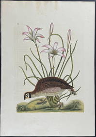
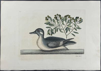
Catesby, Folio - Little Brown Duck with Soap-Wood. 1-98Trillium Antique Prints & Rare Books4.5(30)See Sold PriceFeb 24, 2024
Catesby, Folio - Red Bellied Woodpecker & Hairy Woodpecker with Black Oak. 1-19Trillium Antique Prints & Rare Books4.5(30)See Sold PriceFeb 24, 2024
Antique French Neoclassical Revival Giltwood Mirror and Upholstered 3-Panel ScreenJasper524.5(9.8k)See Sold PriceFeb 28, 2024
GROUP OF FOUR ANTIQUE HAND COLORED STEEL ENGRAVINGS OF FRENCH FASHIONChamberlain's Auction Galleries4.4(50)See Sold PriceFeb 24, 2024
1849 Hand Colored Blair Map of World in HemispheresMatthew Bullock Auctioneers4.7(1.8k)See Sold PriceMar 02, 2024
1849 Orr & Co. Hand Colored Southern Germany MapMatthew Bullock Auctioneers4.7(1.8k)See Sold PriceMar 02, 2024
ANTIQUE FRENCH HAND COLORED INTERIOR DESIGN PRINTAntique Arena Inc.4.5(866)See Sold PriceMar 09, 2024
Napoleon Bonaparte Hand-Colored Engraving, 19th C.Auctions at Showplace4.6(731)See Sold PriceApr 16, 2024