SoldHomann (Heirs of) Guinea propria,Homann (Heirs of) Guinea propria, west Africa with large pictorial cartouche depicting village life, (uncoloured), engraved map with original hand-colouring, 460 x 555mm., a little surface dirSee Sold Price
Guinea (Homann''s Erben): GuineaGuinea (Homann''s Erben) - Guinea propria, nec non Nigritiae vel Terrae Nigrorum maxima pars ... Kupferstich mit einer großen Darstellung aus dem Leben der Eingeborenen, mit zeitgenöss. Grenz- und FSee Sold Price
SoldEast Indies.- Homann Heirs. Carte des Indes OrientalesEast Indies.- Homann Heirs. Carte des Indes Orientales desinée suivant les observations les plus recentes..., showing from India and Ceylon across to New Guinea, engraving with hand-colouring, onSee Sold Price
SoldHomann Heirs: Antique Revolutionary War Map of the USTitle: 1777 Revolutionary War issue of Homann's map of the United States. America Septentrionalis a Domino d'Anville in Galliis edita nunc in Anglia Coloniis in Interiorem Virginiam... Map maker: HomaSee Sold Price
SoldHomann Heirs: Antique Composite Map of West Indies 1740Map: Mappa Geographicae, complectens Indiae Occidentalis/ Carte des Isles de l'Amerique Cartographer: Homann Heirs/J.B.B. d'Anville Place & Date: Nurnberg / 1740 Size: 19" x 22 5/8" Condition: Main WeSee Sold Price
Homann Heirs Carte de l'AsieTitle/Content of Map: Carte de l'Asie Date Printed: 1744 Cartographer: Homann Heirs Size (in): 22 x 19 Decorative antique map of Asia dated to 1744. Coverage include Egypt, Saudia Arabia, the PersianSee Sold Price
SoldHomann Heirs: Antique Map of North & South America 1746Title/Content of Map: Americae mappa generalis Date Printed: 1746 Cartographer: Homann Heirs Material/Medium: Paper Size: 23 1/2" x 21" Hand colored copperplate engraved. Published in Nuremberg. Map hSee Sold Price
SoldHomann Heirs: Dutch Map of Africa, 1737Title: Africa Secundum Legitimas Projectionis Stereographicae regulas et juxta recentissimas relationes et observationes in subsidium vocatis quoque veterum Leonis Africani… Map maker: Johann MatthiSee Sold Price
Homann Heirs/ d’Anville: West Indies Antique Map, 1740Map: Mappa Geographicae, complectens Indiae Occidentalis/ Carte des Isles de l'Amerique Cartographer: Homann Heirs/J.B.B. d'Anville Place & Date: Nurnberg / 1740 Size: 19" x 22 5/8" Condition: Main WeSee Sold Price
SoldHomann Heirs: Antique Plan of Havana and Harbor, 1739Neu und verbesserte Plan der St. u. Hafens Havana A superbly detailed bird's-eye plan of Havana and its harbor, with depth soundings, a numbered key to principal sites, a magnificent martial-motif titSee Sold Price
Homann Heirs: Map of the Western Hemisphere, 1746Map: Western Hemisphere Date Printed: 1746 Cartographer: Homann Heirs Material/Medium: Paper Size: 23 3/4 x 21" Printed in Nuremberg. Thick paper. Hand colored copperplate engraved. Beautiful baroqueSee Sold Price
Homann Heirs: Antique Map of the World, 1720Map: World Date Printed: 1720 Cartographer: Homann Heirs Material/Medium: Paper Size: 21" x 24" Double page on thick paper. One of the most decorative world maps of the 1700's. J.B. Homann is one of tSee Sold Price
Homann Heirs: Antique Celestial Chart, 1740Map: Celestial Chart Date Printed: c 1740's Cartographer: Homann Heirs Material/Medium: Paper Size: ***Approx 22" x 25" Published in Nuremberg. Thick paper. Hand colored copperplate engraved. Based onSee Sold Price
SoldHomann Heirs: Antique Map of Asia, 1746Map: Asia Date Printed: 1746 Cartographer: Homann Heirs Material/Medium: Paper Size: 23 3/4" x 21" Printed in Nuremberg. Hand colored copperplate engraved. Beautiful baroque style cartouche. Please noSee Sold Price
SoldJohn Baptist Homann Heirs, "Vorstellung EinigerJohn Baptist Homann Heirs, "Vorstellung Einiger Gegenden un Plaetze in Nord Arnerika, Franzoesiche und Englische Jurisdiction (City Plans of: Louisburg Quebec Halifax),"1756, hand colored, H. - 20 1/4See Sold Price
Homann Heirs: Antique Map of the World, 1746Map: World Date Printed: 1746 Cartographer: Homann Heirs Material/Medium: Paper Size: 23 3/4" x 21" Printed in Nuremberg. Thick paper. Features the world in double hemispheres. Two projections show poSee Sold Price
Homann Heirs: Antique Map of World in Hemispheres, 1746Map: Planiglobi Terrestris Mappe Monde Date Printed: 1746 Cartographer: Homann Heirs Material/Medium: Paper Size: 23" x 21 1/3" Condition: Excellent The World in double Hemispheres. Two proejctions shSee Sold Price
SoldHomann Heirs: Antique Map of Corsica, 1732Map: Insulae Corsicae olim Cyrus dictae Cartographer: Homann Heirs Place & Date: Nuremberg / 1732 Size: 17" x 20 3/8" Condition: overall age toning, heavier along horizontal centerfold; some light watSee Sold Price
SoldMap of Scandinavia by Homann HeirsHomann Heirs (1724-1848), Scandinavia Complectens Sueciae Daniae & Norvegiae Regna ex Tabulis, hand-colored copper engraving, published in Nuremberg, overall: 23"h x 26"wSee Sold Price
SoldHomann Heirs: Antique Map of Europe, 1746Map: Europe ** Nuremberg?? Date Printed: 1746 Cartographer: Homann Heirs Material/Medium: Paper Size: 21" x 23 1/4" Nuremberg. Hand colored copperplate engraved. Beautiful baroque style cartouche. PleSee Sold Price
SoldHomann Heirs: Antique Map of British West Indies, 1740Map: Dominia Anglorum in praecipuis Insulis Americae Cartographer: Homann Heirs Place & Date: Nuremberg / 1740 Size: 22" x 19 1/4" Condition: outline color; overall age toning; repaired splits at centSee Sold Price
Homann Heirs: Antique Maps of British Colonies, 1745Map: Dominia Anglorum in America Septentrionali Subtitle: Dominia Anglorum in America Septentrionali Specialibus Mappis Londini primum a Mollio edita nune recusa ab Homannianis Hered. Creator: HomannSee Sold Price
SoldHOMANN HEIRS. Neue Welt Karte. Nuremberg, 1784. HOMANN HEIRS. Neue Welt Karte. Nuremberg, 1784. Engraved double hemisphere world map with hand-coloring in wash and outline, sheet 20 3/8 x 25 3/8 in. (518 x 647 mm), plate 18 1/2 x 21 7/8 in. (46See Sold Price
SoldHomann Heirs, Charte van AsienHomann Heirs, Charte van Asien, Homann Heirs (18th c.), "Charte von Asien", c. 1793, hand-colored map of the continent including all of South East Asia and the northern tip of Australia, 20.5"h x 24.5See Sold Price
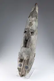
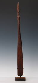
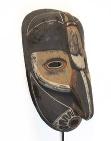
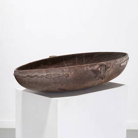
Papua New Guinea Kaminimbit Tribal Mask 29inThe Benefit Shop Foundation Inc.4.3(2.9k)See Sold PriceFeb 28, 2024
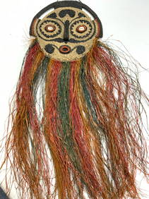
Baga African Nimba Tribal Shoulder Mask Carved Wood and Tacks GuineaArarity Auctions4.6(166)See Sold PriceMar 03, 2024
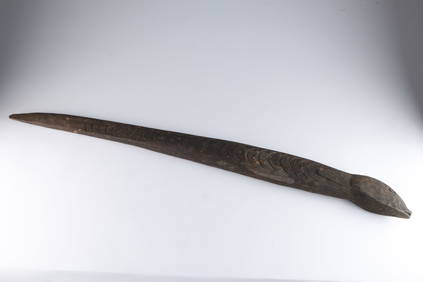
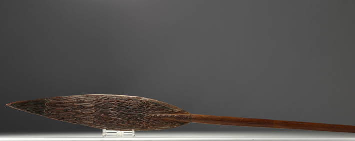
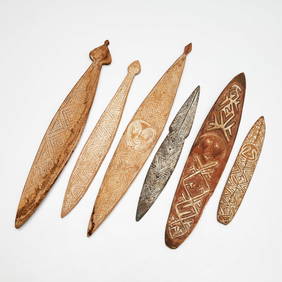
New Guinea, Sepik, Ceremonial paddle in carved wood with traces of polychromy.GOLDFIELD AUCTION4.3(32)See Sold PriceMar 02, 2024
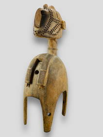
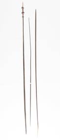
Food Spatula, Geelvink Bay, Northwest Coast Papua New Guinea, Early 20th C. or OlderMaterial Culture4.6(765)See Sold PriceFeb 29, 2024
Johann Homann Hand-Colored Map Engraving, c. 1730Auctions at Showplace4.5(726)See Sold PriceMar 17, 2024
1736 LARGE MAP OF SILESIA POLAND OPPAVIENSIS antique 25 by 34 3/4"Jasper524.5(9.8k)See Sold PriceFeb 27, 2024
1736 LARGE MAP OF SILESIA POLAND KARNOVIENSIS antique 25 x 4 3/4" Duchy of KrnovJasper524.5(9.8k)See Sold PriceFeb 27, 2024
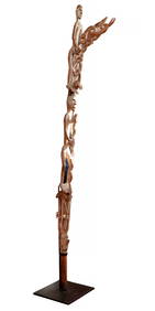
AN EARLY PAPUA NEW GUINEA TRIBAL CARVED WOOD VOTIVE. 25 cm high.Hannam's Auctioneers Ltd4.3(386)See Sold PriceFeb 27, 2024