SoldHomann Heirs, Charte van AsienHomann Heirs, Charte van Asien, Homann Heirs (18th c.), "Charte von Asien", c. 1793, hand-colored map of the continent including all of South East Asia and the northern tip of Australia, 20.5"h x 24.5See Sold Price
Homann (Heirs of) Charte von AsienHomann (Heirs of) Charte von Asien,after F.L. Gussefeld, chinoiserie title cartouche lower left, engraved map with original hand-colouring, 500 x 590mm., a horizontal fold, marginal handling cSee Sold Price
SoldGUSSEFELD, FRANZ LUDWIG; HOMANN HEIRS. Charte uber die GUSSEFELD, FRANZ LUDWIG; HOMANN HEIRS Charte uber die XIII Verenigte Staaten von Nord-America. [Nuremberg,] 1784. Engraved map of the 13 colonies, hand-colored, detailed geographical features, cities,See Sold Price
SoldFive Wonderful 18th Century Maps,c.1702-1793, including 'Asien,' by T.Mollo/Schmidt, 'India Orinetalis,' by S.C.M. George August, 'Carte Indes Orientales,' by Charles Henry Friso/Homann Erben and 'Charte von Asien,' by F.L. GuslefeldSee Sold Price
SoldMILITARY - HOMANN, HEIRS.MILITARY - HOMANN, HEIRS. Kriegs-Ingenieur- u. Artillerie-Charte, welche die vornehmste Terminos, so wohl der Geometrie, Fortification, Artillerie u. Ernst-Feuerwerck als auch anderer im Krieg vorkommSee Sold Price
Homann Map of Asia*** START PRICE IS THE RESERVE *** [Asia] HOMANN, Johann Baptiste (1664-1724). Charte von Asien Nach den bewahrtesten... Engraved map with original hand color in outline. Nurenberg: 1793. 21 1/2" x 25See Sold Price
JOHANN BAPTIST HOMANN (HOMANN HEIRS) 1664JOHANN BAPTIST HOMANN (HOMANN HEIRS) 1664 Oberkammlach/Allgäu - 1724 Nürnberg CHARTE VON DER MITTELMARK (...) Engraving, coloured, on paper. Visible size 60,5 x 49,5 cm (f. 86 x 74 cm). InscSee Sold Price
SoldHOMANN HEIRS. Der Hollaendisch-OstindianischenHOMANN HEIRS. Der Hollaendisch-Ostindianischen Compagnie Weltberuhmte Haupt-Handels und Niederlags-Stadt Batavia in Asien auf dem Grossen Eyland Java. Double-page engraved plan of Batavia (Jakarta) wiSee Sold Price
TWO MAPS OF ALSACE Gilliam van der Gouwen (published byTWO MAPS OF ALSACE Gilliam van der Gouwen (published by Nicolaes Visscher) and Homann Heirs, 17th and 18th century 2 engravings, partly coloured, on different papers. Sheet size 61 x 53 cm / 115 x 53,See Sold Price
Homann map of original 13 United States 1784Title: Charte uber die XIII Vereinigte Staaten von Nord-America... Author: Homann Heirs Description: Copper-engraved map, hand-colored. 46x58 cm. (18x23").Early map of the newly independent United StaSee Sold Price
SoldCharte von Asien. Kol. Kupferstichkarte, nach GüssefeldCharte von Asien. Kol. Kupferstichkarte, nach Güssefeld b. Homann Erben, datiert 1793. Plattengröße ca. 50 x 61 cm. Montiert auf Karton. Col. copperengr. map. - Mounted on cardboard. - Small marginSee Sold Price
SoldHomann Erben Charte generale de la tatarie Chinoise.Asien-China Homann Erben Charte generale de la tatarie Chinoise. Tatariae Sinensis Mappa Geographica ex Tabulis specialibus R.R.P.P. Jesuitarum. 1749. Teilkol. Kupferstich von Tobias Mayer bei HomannSee Sold Price
SoldFRANZ LUDWIG GUSSEFELD (GERMAN, 1744-1807 HEIRS OFFRANZ LUDWIG GUSSEFELD (GERMAN, 1744-1807 HEIRS OF JOHANN BAPTIST HOMANN (GERMAN, 1664-1724) MAP OF THE UNITED STATES, hand-colored engraving on paper, titled in German "Charte Uber Die XIII VereingteSee Sold Price
SoldHomann Heirs: Antique Revolutionary War Map of the USTitle: 1777 Revolutionary War issue of Homann's map of the United States. America Septentrionalis a Domino d'Anville in Galliis edita nunc in Anglia Coloniis in Interiorem Virginiam... Map maker: HomaSee Sold Price
SoldHomann Heirs: Antique Composite Map of West Indies 1740Map: Mappa Geographicae, complectens Indiae Occidentalis/ Carte des Isles de l'Amerique Cartographer: Homann Heirs/J.B.B. d'Anville Place & Date: Nurnberg / 1740 Size: 19" x 22 5/8" Condition: Main WeSee Sold Price
Homann Heirs Carte de l'AsieTitle/Content of Map: Carte de l'Asie Date Printed: 1744 Cartographer: Homann Heirs Size (in): 22 x 19 Decorative antique map of Asia dated to 1744. Coverage include Egypt, Saudia Arabia, the PersianSee Sold Price
SoldHomann Heirs: Antique Map of North & South America 1746Title/Content of Map: Americae mappa generalis Date Printed: 1746 Cartographer: Homann Heirs Material/Medium: Paper Size: 23 1/2" x 21" Hand colored copperplate engraved. Published in Nuremberg. Map hSee Sold Price
SoldHomann Heirs: Dutch Map of Africa, 1737Title: Africa Secundum Legitimas Projectionis Stereographicae regulas et juxta recentissimas relationes et observationes in subsidium vocatis quoque veterum Leonis Africani… Map maker: Johann MatthiSee Sold Price
Homann Heirs/ d’Anville: West Indies Antique Map, 1740Map: Mappa Geographicae, complectens Indiae Occidentalis/ Carte des Isles de l'Amerique Cartographer: Homann Heirs/J.B.B. d'Anville Place & Date: Nurnberg / 1740 Size: 19" x 22 5/8" Condition: Main WeSee Sold Price
SoldHomann Heirs: Antique Plan of Havana and Harbor, 1739Neu und verbesserte Plan der St. u. Hafens Havana A superbly detailed bird's-eye plan of Havana and its harbor, with depth soundings, a numbered key to principal sites, a magnificent martial-motif titSee Sold Price
Homann Heirs: Map of the Western Hemisphere, 1746Map: Western Hemisphere Date Printed: 1746 Cartographer: Homann Heirs Material/Medium: Paper Size: 23 3/4 x 21" Printed in Nuremberg. Thick paper. Hand colored copperplate engraved. Beautiful baroqueSee Sold Price
Homann Heirs: Antique Map of the World, 1720Map: World Date Printed: 1720 Cartographer: Homann Heirs Material/Medium: Paper Size: 21" x 24" Double page on thick paper. One of the most decorative world maps of the 1700's. J.B. Homann is one of tSee Sold Price
Homann Heirs: Antique Celestial Chart, 1740Map: Celestial Chart Date Printed: c 1740's Cartographer: Homann Heirs Material/Medium: Paper Size: ***Approx 22" x 25" Published in Nuremberg. Thick paper. Hand colored copperplate engraved. Based onSee Sold Price
SoldHomann Heirs: Antique Map of Asia, 1746Map: Asia Date Printed: 1746 Cartographer: Homann Heirs Material/Medium: Paper Size: 23 3/4" x 21" Printed in Nuremberg. Hand colored copperplate engraved. Beautiful baroque style cartouche. Please noSee Sold Price
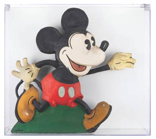
Mickey Mouse Old King Cole Animated Window Display.Van Eaton Galleries4.6(99)See Sold PriceMar 02, 2024
A Rare Ingersoll Donald Duck Pocket Watch and Box.Van Eaton Galleries4.6(99)See Sold PriceMar 02, 2024
A Disney Store Sorcerer's Apprentice Broom Figure.Van Eaton Galleries4.6(99)See Sold PriceMar 02, 2024
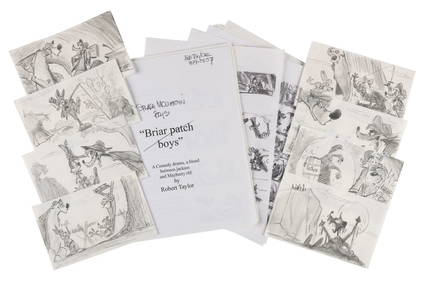
A "Splash Mountain Boys" Pitch with Story Panels.Van Eaton Galleries4.6(99)See Sold PriceMar 02, 2024
An Original "Haunted Mansion" Stretching Portrait.Van Eaton Galleries4.6(99)See Sold PriceMar 02, 2024
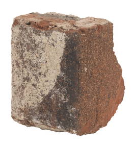
A Disneyland Haunted Mansion Brick and Mortar Fragment.Van Eaton Galleries4.6(99)See Sold PriceMar 02, 2024
De Jode, Rare, pub. 1593 - Map of Luxembourg (Lutzenburgii montuosissimi ac saltuosissimi ducatusTrillium Antique Prints & Rare Books4.5(30)See Sold PriceFeb 24, 2024
De Jode, Rare, pub. 1593 - Map of the British Isles [England, Scotland, Ireland] (Angliae Scotiae etTrillium Antique Prints & Rare Books4.5(30)See Sold PriceFeb 24, 2024
De Jode, Rare, pub. 1593 - Map of Italy (Italiae Totius Orbis olim Domatricis Nova ExactissTrillium Antique Prints & Rare Books4.5(30)See Sold PriceFeb 24, 2024
De Jode, Rare, pub. 1593 - Map of the Czech Republic or Kingdom of Bohemia (Chorographia insignisTrillium Antique Prints & Rare Books4.5(30)See Sold PriceFeb 24, 2024
De Jode, Rare, pub. 1593 - Map of the Middle East, Eastern Asia (Primae Partis Asiae accurataTrillium Antique Prints & Rare Books4.5(30)See Sold PriceFeb 24, 2024
1736 LARGE MAP OF SILESIA POLAND OPPAVIENSIS antique 25 by 34 3/4"Jasper524.5(9.8k)See Sold PriceFeb 27, 2024
1731 ANCIENT INSCRIPTIONS GREEK & LATIN antique Antiquae inscriptiones M. GUDEJasper524.5(9.8k)See Sold PriceFeb 27, 2024
1736 LARGE MAP OF SILESIA POLAND KARNOVIENSIS antique 25 x 4 3/4" Duchy of KrnovJasper524.5(9.8k)See Sold PriceFeb 27, 2024


![De Jode, Rare, pub. 1593 - Map of the British Isles [England, Scotland, Ireland] (Angliae Scotiae et (1 of 2)](https://p1.liveauctioneers.com/6581/319571/171593327_1_x.jpg?height=282&quality=70&version=1707853304)


