ATLAS of ANTIENT GEOGRAPHY by SAMUEL BUTLER 1843John McInnis Auctioneers,LLC4.6(502)See Sold PriceFeb 24, 2024
18TH C. ANTIQUE MAP: FRENCH & INDIAN WAR, FRAMEDThomaston Place Auction Galleries4.4(386)See Sold PriceFeb 24, 2024
Rand McNally Railroad Map Cabinet w/ 21 Railroad MapsRail & Road Auctions4.6(165)See Sold PriceMar 08, 2024
Keith Haring - Ink on New York Map, Best Buddies, Inscribed, Signed, and DatedSapphire Auction Gallery4(67)See Sold PriceMar 02, 2024
LATE 17TH C. FRENCH MAP OF THE NEW WORLD BY ALEXIS-HUBERT JAILLOT (1632-1712)Thomaston Place Auction Galleries4.4(386)See Sold PriceFeb 24, 2024
Central Railroad of New Jersey Map of Sandy Hook Route-ca. 1903JM Hobby Supply and Railroad Artifact Auctions4.4(126)See Sold PriceFeb 24, 2024
Lot of Six Mixed Atlas Box Cars-HO Scale-New in BoxJM Hobby Supply and Railroad Artifact Auctions4.4(126)See Sold PriceFeb 25, 2024
Rand McNally/Santa Fe Railroad Map of Iowa-1912JM Hobby Supply and Railroad Artifact Auctions4.4(126)See Sold PriceFeb 24, 2024
NICOLAES VISSCHER (NETHERLANDS, 1618-1709) MAP OF THE NEW WORLDThomaston Place Auction Galleries4.4(386)See Sold PriceFeb 24, 2024
17TH C. WORLD MAP BY NICOLAES VISSCHER (NETHERLANDS, 1618-1709)Thomaston Place Auction Galleries4.4(386)See Sold PriceFeb 24, 2024
Lot of Six Mixed Atlas Cabooses-HO Scale-New in BoxJM Hobby Supply and Railroad Artifact Auctions4.4(126)See Sold PriceFeb 25, 2024
SoldENGRAVED MAP, PACIFIC OCEAN, BY CORONELLI.Map entitled “Mare Del Sud detto altrimenti Mare Pacifico”, drawn by Il P.M. CORONELLI and dated 1654 (near New Zealand), but likely later. Image sight size 18.5”H x 24.75, Overall iSee Sold Price
Times Atlas 1895 Antique Map. Pacific OceanLithograph Map Published 1895, London for "The Times Atlas" Paper Size: 16 x 10 inch (41 x 26cm) Good ConditionSee Sold Price
Times Atlas 1895 Antique Map. Pacific OceanLithograph Map Published 1895, London for "The Times Atlas" Paper Size: 16 x 10 inch (41 x 26cm) Good ConditionSee Sold Price
SoldMAPS, Pacific Ocean, U.S. NavyPacific Ocean. U.S. Navy/Andriveau-Goujon, [Lot of 2] Naval Chart of the Pacific and Western Atlantic [and] Oceanie, 1860-1901 (circa). This lot contains two maps focused on colonial ownership in theSee Sold Price
SoldPacific OceanTitle/Content of Map: Pacific Ocean Date Printed: 1838/1841 Cartographer: Thomas G. Bradford Material/Medium: Paper Size: 16 3/4" x 13" Featuring Australia and Hawaii. From Russian controlled Alaska dSee Sold Price
SoldMitchell: Antique Map of Pacific Ocean Islands, 1869Title/Content of Map: Pacific Ocean Islands with Australia Date Printed: 1869 Cartographer: Augustus S. Mitchell Material/Medium: Paper Size: 15 1/3" x 12" Hand colored engraved Map. Published in PhilSee Sold Price
Bradford: Antique Map of Pacific Ocean & Islands, 1838Map: Pacific Ocean & Islands Date Printed: 1838-1841 Cartographer: Thomas G. Bradford Material/Medium: Paper Size: 16 3/4" x 13" Condition: Excellent Hand colored. A General Atlas of the World with aSee Sold Price
Pacific Ocean Its Islands & CoastsTitle/Content of Map: Pacific Ocean Its Islands & Coasts Date: 1838 Cartographer: EVANS, W. GARDNER Publisher: E.J. HUNTINGTON, Size: 12Height - 9.5Width Division into four regions, three of which areSee Sold Price
Pacific Ocean Its Islands & CoastsTitle/Content of Map: Pacific Ocean Its Islands & Coasts Date Printed: 1838 Cartographer: EVANS, W. GARDNER Size: 12X9.5 Division into four regions, three of which are Eastern Oceanica or Polynesia, CSee Sold Price
Pacific Ocean – West Coast USABritish Admiralty ChartTitle/Content of Map: Pacific Ocean – West Coast USA British Admiralty Chart 787, published 1877 Date Printed: 1877 Cartographer: British Admiralty Material/Medium: thick paper Size: large, 71x112 cSee Sold Price
Pacific Ocean.Title/Content of Map: Pacific Ocean. Date: 1830 Cartographer: HALL, SIDNEY Publisher: LONGMAN, REES, ORME, BROWN AND GREEN Size: 16.25Height - 20.25Width Hawaii is called Sandwich Island and "disc'd iSee Sold Price
Pacific Ocean – Phoenix Islands British Admiralty ChartTitle/Content of Map: Pacific Ocean – Phoenix Islands British Admiralty Chart 184, published 1950 Date: 1950 Cartographer: British Admiralty Material/Medium: thick paper Size: standard Unused and deSee Sold Price
Pacific Ocean – Caroline Islands British AdmiraltyTitle/Content of Map: Pacific Ocean – Caroline Islands British Admiralty Chart 977, published 1928 Date: 1928 Cartographer: British Admiralty Material/Medium: thick paper Size: standard Used and detSee Sold Price
Pacific Ocean – West Coast USABritish Admiralty ChartTitle/Content of Map: Pacific Ocean – West Coast USABritish Admiralty Chart 787, published 1877 Date: 1877 Cartographer: British Admiralty Material/Medium: thick paper Size: large, 71x112 cm (28x44See Sold Price
SoldArrowsmith: Antique Map of Pacific Ocean, 1823Title/Content of Map: 1823 Arrowsmith Map of Pacific Ocean -- Pacific Ocean Date Printed: 1823, London / Edinburgh Cartographer: A Arrowsmith Size: 9.8 x 8 in. A striking Arrowsmith map, with wonderfuSee Sold Price
Thomson: Antique Map of Pacific Ocean Islands, 1817Title/Content of Map: 'Map of the islands in the Pacific Ocean. Owhyhee/Hawaii. Karakakooa Bay, Owhyhee. Otaheite/Tahiti. Matavia Bay, Otaheite' Date Printed: 1817 Image Size: Approx 53.0 x 66.0cm, 21See Sold Price
SoldAbraham Ortelius map of Pacific OceanCartographer: Abraham Ortelius Title: Maris Pacifici, (quod vulgo Mar del Zur) cum Regionibus Circumiacentibus, Insulisque in Codem Passim Sparsis, Novissima Descriptio Subject: Pacific Ocean PublisheSee Sold Price
Thomson: Antique Map of Pacific Ocean Islands, 1817Title/Content of Map: 'Map of the islands in the Pacific Ocean. Owhyhee. Karakakooa Bay, Owhyhee. Otaheite. Matavia Bay, Otaheite' Date Printed: 1817 Image Size: Approx 53.0 x 66.0cm, 21 x 26 inches (See Sold Price
Ortelius Map of Pacific OceanORTELIUS, Abraham (1527-1598) Maris Pacifici, (quod vulgo Mar del Zur) cum regionaribus circumiacentibus, insulisque in eodem passim sparsis, novissima descripto. Engraved map with original hand colorSee Sold Price
Arrowsmith: Map of Pacific Ocean, 1823Map: 1823 Arrowsmith Map of Pacific Ocean -- Pacific Ocean Cartographer: A Arrowsmith Year / Place: 1823, London / Edinburgh Map Dimensions: 9.8 x 8 in. A striking Arrowsmith map, with wonderful colorSee Sold Price
Weller: Antique Map of Pacific Ocean, 1863TITLE/CONTENT OF MAP: 'The Pacific Ocean' Sandwich Islands/Hawaii Australia New Zealand &c. DATE PRINTED: 1863 IMAGE SIZE: Approx 47.0 x 65.0cm, 18.5 x 25.75 inches (Large); Please note that this is aSee Sold Price
Map of Pacific Ocean. 1839.Print of steel engraving. Author unknown.Engraved by G. Boynton.Notes: Entered according to act of Congrass on the 9th day of March by S. G. Goodrich of Mass.From „The second book of History, includSee Sold Price
1831 Woodbridge Map of North America, Europe, Asia and on verso Map of Pacific Ocean -- PolarTitle: 1831 Woodbridge Map of North America, Europe, Asia and on verso Map of Pacific Ocean -- Polar Projection of North America and Asia [verso] Pacific Ocean with a View of Australia and Polynesia CSee Sold Price
SoldWall map of Pacific OceanHeading: (Wall Map) Author: Cram, George F. Title: Cram's Detailed Map of the Pacific Ocean Place Published: Indianapolis, Ind Publisher:George F. Cram Co. Date Published: 1930s DescripSee Sold Price
EARLY 18TH C. DUTCH CHART OF PACIFIC OCEAN BY FREDERIK DE WIT (1629-1706) WITH CALIFORNIA AS ANThomaston Place Auction Galleries4.4(386)See Sold PriceFeb 24, 2024
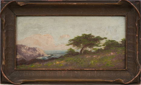
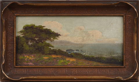
Antique California Coastal Beach Scene Pacific Ocean Framed American Impressionist Oil PaintingCurated Gallery Auctions4.6(120)See Sold PriceFeb 25, 2024
Antique California Coastal Beach Scene Pacific Ocean Framed American Impressionist Oil PaintingCurated Gallery Auctions4.6(120)See Sold PriceFeb 25, 2024
Antique Natural Cream White Tridacna Squamosa Shell from S Pacific OceanNeo FineArts Inc4.4(12)See Sold PriceFeb 25, 2024
Mint Picture Postcard French Colonies Tahiti & Moorea Pacific Ocean IslandMynt Auctions4.6(680)See Sold PriceFeb 28, 2024
The Sparkling Pacific Ocean Mixed Media Original on canvas David Lloyd GloverArt Legacy Auctions4.5(217)See Sold PriceFeb 24, 2024
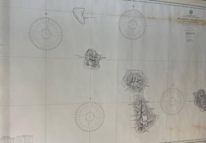
CHART: South Pacific Ocean / SOCIETY ISLANDS - WESTERN GROUP/ HUAHINE TO MAUPITI With theChurchill Galleries3.7(213)See Sold PriceFeb 26, 2024
Pearl and Diamond Necklace - 14KT Yellow GoldFederal Assets Auctioneers4.4(411)See Sold PriceFeb 24, 2024
Pearl and Diamond Necklace - 14KT White GoldFederal Assets Auctioneers4.4(411)See Sold PriceFeb 25, 2024
Pearl and Diamond Necklace - 14KT Yellow GoldFederal Assets Auctioneers4.4(411)See Sold PriceFeb 26, 2024
Vintage Fleischmann HO Union Pacific Ocean View Car ARapid Estate Liquidators and Auction Gallery4.5(1.1k)See Sold PriceFeb 29, 2024
Vintage Fleischmann HO Union Pacific Ocean View Car BRapid Estate Liquidators and Auction Gallery4.5(1.1k)See Sold PriceFeb 29, 2024
A Chinese calligraphy in running script, by Liang Qichao (Chinese, 1873-1929), given to Luo ChangOakridge Auction Gallery4.5(190)See Sold PriceMar 17, 2024
Pearl and Diamond Necklace - 14KT White GoldFederal Assets Auctioneers4.4(411)See Sold PriceFeb 28, 2024
HIROSHI SUGIMOTO, SOUTH PACIFIC OCEAN, TEARAI, 1991White Knight Auction, Inc4.7(248)See Sold PriceMar 03, 2024
Pearl and Diamond Necklace - 14KT White GoldFederal Assets Auctioneers4.4(411)See Sold PriceMar 01, 2024