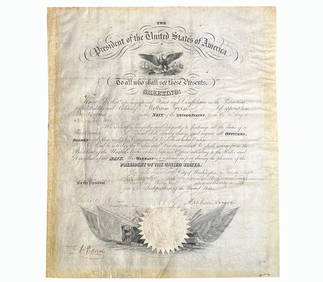
ATLAS of ANTIENT GEOGRAPHY by SAMUEL BUTLER 1843John McInnis Auctioneers,LLC4.6(502)See Sold PriceFeb 24, 2024
18TH C. ANTIQUE MAP: FRENCH & INDIAN WAR, FRAMEDThomaston Place Auction Galleries4.4(386)See Sold PriceFeb 24, 2024
Rand McNally Railroad Map Cabinet w/ 21 Railroad MapsRail & Road Auctions4.6(165)See Sold PriceMar 08, 2024
Keith Haring - Ink on New York Map, Best Buddies, Inscribed, Signed, and DatedSapphire Auction Gallery4(67)See Sold PriceMar 02, 2024
LATE 17TH C. FRENCH MAP OF THE NEW WORLD BY ALEXIS-HUBERT JAILLOT (1632-1712)Thomaston Place Auction Galleries4.4(386)See Sold PriceFeb 24, 2024
Central Railroad of New Jersey Map of Sandy Hook Route-ca. 1903JM Hobby Supply and Railroad Artifact Auctions4.4(126)See Sold PriceFeb 24, 2024
Lot of Six Mixed Atlas Box Cars-HO Scale-New in BoxJM Hobby Supply and Railroad Artifact Auctions4.4(126)See Sold PriceFeb 25, 2024
Rand McNally/Santa Fe Railroad Map of Iowa-1912JM Hobby Supply and Railroad Artifact Auctions4.4(126)See Sold PriceFeb 24, 2024
NICOLAES VISSCHER (NETHERLANDS, 1618-1709) MAP OF THE NEW WORLDThomaston Place Auction Galleries4.4(386)See Sold PriceFeb 24, 2024
17TH C. WORLD MAP BY NICOLAES VISSCHER (NETHERLANDS, 1618-1709)Thomaston Place Auction Galleries4.4(386)See Sold PriceFeb 24, 2024
Lot of Six Mixed Atlas Cabooses-HO Scale-New in BoxJM Hobby Supply and Railroad Artifact Auctions4.4(126)See Sold PriceFeb 25, 2024
EASTERN HEMISPHERE 'Carte Generale'. Australia coast incomplete. MALLET 1683 mapTITLE OF THE MAP: 'Carte Generale' (De la Sphere) Marked on the map are Paris, Constantinpole & the Cape Verde Islands with I. St Antoine (Santo Antão) specifically named. Partial outline of TerrSee Sold Price
EASTERN HEMISPHERE 'Carte Generale'. Australia coast incomplete. MALLET 1683 mapTITLE OF THE MAP: 'Carte Generale' (De la Sphere) Marked on the map are Paris, Constantinpole & the Cape Verde Islands with I. St Antoine (Santo Antão) specifically named. Partial outline of TerrSee Sold Price
Mallet: Antique Map of the Eastern Hemisphere, 1683Carte Generale' Eastern Hemisphere, Australia coast incomplete. Marked on the map are Paris, Constantinpole & the Cape Verde Islands with I. St Antoine (Santo Antão) specifically named. Partial outliSee Sold Price
EASTERN HEMISPHERE. Europe Asia Africa. Australia incomplete. MALLET 1683 mapTITLE OF THE MAP: 'Ancien Continent avec plusieurs Isles' (Du Globe Terrestre) Australia appears partly outlined. Enhanced with small ships. Partial outline of Terra Australis, the hypothesised southeSee Sold Price
EASTERN HEMISPHERE. Australia incomplete. Asia Africa Europe. MALLET 1683 mapTITLE OF THE MAP: 'Ancien Continent avec plusieurs Isles, Oceans, Mers, Golfes' (Du Globe Terrestre) Partial outline of Terra Australis, the hypothesised southern continent, is shown. DATE PRINTED: 16See Sold Price
EASTERN HEMISPHERE. Australia incomplete. Europe Asia Africa. MALLET 1683 mapTITLE OF THE MAP: 'Ancien Continent avec plusieurs Isles, Oceans et Mers' (Du Globe Terrestre) Partial outline of Terra Australis, the hypothesised southern continent, is shown. DATE PRINTED: 1683 IMASee Sold Price
EASTERN HEMISPHERE. Europe Asia Africa. Australia incomplete. MALLET 1683 mapTITLE OF THE MAP: 'Ancien Continent avec plusieurs Isles' (Du Globe Terrestre) Australia appears partly outlined. Enhanced with small ships. Partial outline of Terra Australis, the hypothesised southeSee Sold Price
E. Hemisphere: Australia Incomplete... 1683 MapEastern Hemisphere. Australia Incomplete. Europe Asia Africa. Mallet 1683 Map. Title of the Map: 'ancien Continent Avec Plusieurs Isles, Oceans Et Mers' partial Outline of Terra Australis, the HypotheSee Sold Price
EASTERN HEMISPHERE 'Carte Generale'. Australia coastTITLE OF THE MAP: 'Carte Generale' Marked on the map are Paris, Constantinpole & the Cape Verde Islands with I. St Antoine (Santo Antão) specifically named. Partial outline of Terra Australis, the hySee Sold Price
EASTERN HEMISPHERE 'Carte Generale'. Australia coastTITLE OF THE MAP: 'Carte Generale' Marked on the map are Paris, Constantinpole & the Cape Verde Islands with I. St Antoine (Santo Antão) specifically named. Partial outline of Terra Australis, theSee Sold Price
Mallet: EASTERN HEMISPHERE. Australia incomplete. AsiaTITLE OF THE MAP: 'Ancien Continent avec plusieurs Isles, Oceans, Mers, Golfes' Partial outline of Terra Australis, the hypothesised southern continent, is shown. DATE PRINTED: 1683 IMAGE SIZE: ApproxSee Sold Price
Mallet: Antique Map of the Eastern Hemisphere, 1683Title/Content of Map: 'Ancien Continent avec plusieurs Isles, Oceans, Mers, Golfes' Partial outline of Terra Australis, the hypothesised southern continent, is shown. Australia incomplete. Asia AfricaSee Sold Price
Mallet: Antique Map of the Eastern Hemisphere, 1683Title/Content of Map: 'Cercles de Longitude' Tenerife is marked. Partial outline of Terra Australis, the hypothesised southern continent, is shown. The outline of Australia is shown incomplete. Date PSee Sold Price
EASTERN HEMISPHERE. Shows incomplete Australian coastline. MALLET 1683 old mapTITLE OF THE MAP: 'Ancien Continent' (Du Globe Terrestre) Partial outline of Terra Australis, the hypothesised southern continent, is shown. DATE PRINTED: 1683 IMAGE SIZE: Approx Overall page size 13See Sold Price
EASTERN HEMISPHERE. Shows incomplete Australian coastline. MALLET 1683 old mapTITLE OF THE MAP: 'Ancien Continent' (Du Globe Terrestre) Partial outline of Terra Australis, the hypothesised southern continent, is shown. DATE PRINTED: 1683 IMAGE SIZE: Approx Overall page size 13See Sold Price
EASTERN HEMISPHERE. Australia incomplete. Asia AfricaTITLE OF THE MAP: 'Ancien Continent avec plusieurs Isles, Oceans, Mers, Golfes' Partial outline of Terra Australis, the hypothesised southern continent, is shown. DATE PRINTED: 1683 IMAGE SIZE: ApproxSee Sold Price
EASTERN HEMISPHERE. Circles of Longitude. Southern continent. MALLET 1683 mapTITLE OF THE MAP: 'Cercles de Longitude' (De la Sphere) Tenerife is marked. Partial outline of Terra Australis, the hypothesised southern continent, is shown. The outline of Australia is shown incomplSee Sold Price
Mallet: Antique Map of Southern Hemisphere, 1683Title of the Map: 'Continent Meridional Austral ou Antarctique' SOUTHERN HEMISPHERE Australia/New Holland incomplete unknown Date Printed: 1683 Image Size: Approx Overall page size 13 x 21cm approximaSee Sold Price
Mallet: Antique Map of the Southern Hemisphere, 1683Map Title: 'Continent Meridional Austral ou Antarctique' Southern Hemisphere, Australia/New Holland incomplete unknown Date Printed: 1683 Image Size: Approx Overall page size 13 x 21cm approximately (See Sold Price
Southern Hemisphere Australia/ Holland, Mallet 1683 MapTitle of the Map: 'continent Meridional Austral Ou Antarctique' date Printed: 1683 image Size: Approx Overall Page Size 13 X 21cm Approximately (5 X 8 Inches); Image Size 10.5 X 14.5cm Approximately (See Sold Price
SOUTHERN HEMISPHERE Australia/New Holland incomplete unknown. MALLET 1683 mapTITLE OF THE MAP: 'Continent Meridional Austral ou Antarctique' (Des Terres Australes) DATE PRINTED: 1683 IMAGE SIZE: Approx Overall page size 13 x 21cm approximately (5 x 8 inches); image size 10.5 xSee Sold Price
FRANCE. 'Carte Generale'. Towns, rivers & provinces. MALLET 1683 old mapTITLE OF THE MAP: 'Carte Generale de France' (De L'Europe) DATE PRINTED: 1683 IMAGE SIZE: Approx Overall page size 26 x 21cm approximately (10 x 8 inches); image size 21 x 14.5cm approximately (8 x 5.See Sold Price
Chicago and Eastern Illinois RR Annual Reports-1878 to 1887JM Hobby Supply and Railroad Artifact Auctions4.4(126)See Sold PriceFeb 24, 2024
Central Railroad of New Jersey Map of Sandy Hook Route-ca. 1903JM Hobby Supply and Railroad Artifact Auctions4.4(126)See Sold PriceFeb 24, 2024
Eastern RR Summer Book of Tours-1884JM Hobby Supply and Railroad Artifact Auctions4.4(126)See Sold PriceFeb 24, 2024
Timetable, Paper and Ephemera Lot-Eastern USA RailroadsJM Hobby Supply and Railroad Artifact Auctions4.4(126)See Sold PriceFeb 24, 2024
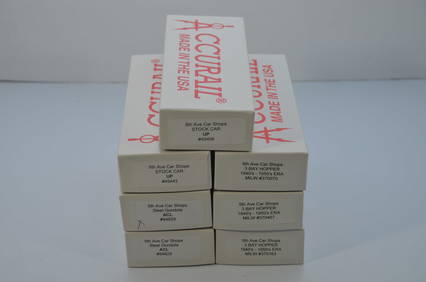
Seven Mixed Accurail/5th Ave Car Shops Midwest/Eastern RR Freight Cars-HO Scale-NewJM Hobby Supply and Railroad Artifact Auctions4.4(126)See Sold PriceFeb 25, 2024
17TH C. WORLD MAP BY NICOLAES VISSCHER (NETHERLANDS, 1618-1709)Thomaston Place Auction Galleries4.4(386)See Sold PriceFeb 24, 2024
EARLY 18TH C. DUTCH CHART OF PACIFIC OCEAN BY FREDERIK DE WIT (1629-1706) WITH CALIFORNIA AS ANThomaston Place Auction Galleries4.4(386)See Sold PriceFeb 24, 2024
4 Throwing/Fighting Clubs, Aboriginal, Eastern Australia, Early 20th C.Material Culture4.6(765)See Sold PriceFeb 29, 2024
African Ethnographic Art Collector's Lot, Mid 20th C.Material Culture4.6(765)See Sold PriceFeb 29, 2024
Willem Blaeu, Etc. 17th C. Antiquarian Maps, 2Auctions at Showplace4.5(726)See Sold PriceMar 17, 2024
Two (2) Antique 18th C. Copper Engraved Framed Maps - America & EuropeMagnusson Art Group4.5(46)See Sold PriceMar 14, 2024
Duval - Pair: Map of India & Map of MaldivesTrillium Antique Prints & Rare Books4.5(30)See Sold PriceFeb 24, 2024
Wilson - Carolina Parrot & Flycatchers. 26Trillium Antique Prints & Rare Books4.5(30)See Sold PriceFeb 24, 2024
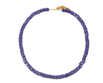
A strand of Russian/Eastern European blue glass trade beadsJohn Moran Auctioneers, Inc.4.7(453)See Sold PriceMar 12, 2024