ATLAS of ANTIENT GEOGRAPHY by SAMUEL BUTLER 1843John McInnis Auctioneers,LLC4.6(502)See Sold PriceFeb 24, 2024
18TH C. ANTIQUE MAP: FRENCH & INDIAN WAR, FRAMEDThomaston Place Auction Galleries4.4(386)See Sold PriceFeb 24, 2024
Rand McNally Railroad Map Cabinet w/ 21 Railroad MapsRail & Road Auctions4.6(165)See Sold PriceMar 08, 2024
Keith Haring - Ink on New York Map, Best Buddies, Inscribed, Signed, and DatedSapphire Auction Gallery4(67)See Sold PriceMar 02, 2024
LATE 17TH C. FRENCH MAP OF THE NEW WORLD BY ALEXIS-HUBERT JAILLOT (1632-1712)Thomaston Place Auction Galleries4.4(386)See Sold PriceFeb 24, 2024
Central Railroad of New Jersey Map of Sandy Hook Route-ca. 1903JM Hobby Supply and Railroad Artifact Auctions4.4(126)See Sold PriceFeb 24, 2024
Lot of Six Mixed Atlas Box Cars-HO Scale-New in BoxJM Hobby Supply and Railroad Artifact Auctions4.4(126)See Sold PriceFeb 25, 2024
Rand McNally/Santa Fe Railroad Map of Iowa-1912JM Hobby Supply and Railroad Artifact Auctions4.4(126)See Sold PriceFeb 24, 2024
NICOLAES VISSCHER (NETHERLANDS, 1618-1709) MAP OF THE NEW WORLDThomaston Place Auction Galleries4.4(386)See Sold PriceFeb 24, 2024
17TH C. WORLD MAP BY NICOLAES VISSCHER (NETHERLANDS, 1618-1709)Thomaston Place Auction Galleries4.4(386)See Sold PriceFeb 24, 2024
Lot of Six Mixed Atlas Cabooses-HO Scale-New in BoxJM Hobby Supply and Railroad Artifact Auctions4.4(126)See Sold PriceFeb 25, 2024
Northern South America, 1843Title/Content of Map: Northern South America, 1843 Date Printed: 1843, Gotha Cartographer: F. von Stulpnagel / Adolf Steiler Size: 15 3/4" x 12 5/8" The upper half of Stulpnagel's highly detailed two-See Sold Price
Northern South America, 1843Title/Content of Map: Northern South America, 1843 Date Printed: 1843, Gotha Cartographer: Stulpnagel / Perthes Size: 15 3/4" x 12 5/8" The upper half of a wonderfully detailed two-part map of South ASee Sold Price
Northern South America, 1843Title/Content of Map: Northern South America, 1843 Date Printed: 1843, Gotha Cartographer: F. von Stulpnagel / Adolf Steiler / Justus Perthes Size: 15 3/4" x 12 5/8" The upper half of Stulpnagel's higSee Sold Price
Northern South America, 1843Title/Content of Map: Northern South America, 1843 Date Printed: 1843, Gotha Cartographer: F. von Stulpnagel / Adolf Steiler / Justus Perthes Size: 15 3/4" x 12 5/8" The upper half of Stulpnagel's higSee Sold Price
Northern South America, 1843Title/Content of Map: Northern South America, 1843 Date Printed: 1843, Gotha Cartographer: F. von Stulpnagel / Adolf Steiler / Justus Perthes Size: 15 3/4" x 12 5/8" The upper half of Stulpnagel's higSee Sold Price
Stulpnagel / Perthes: Northern South AmericaThe upper half of a detailed two-part German map of South America, from Stieler's Hand Atlas, published by Justus Perthes.; Stulpnagel; gotha / 1843; 15 3/4" x 12 5/8"; outline color; overall age toniSee Sold Price
SoldLot of 6 Hand Colored Engraved MapsA lot of six engraved, hand colored maps. Engraving by Wm. C. Woodbridge of MA, 1843. "The World", "South America & Africa", "Political Map Southern Division, USA", "Political Map Northern Division, USee Sold Price
Soldde l'Isle: Antique Map of Northern South America, 1730Map: Carte de la Terre Ferme, du Perou, du Bresil, et du Pays des Amazones Cartographer: de l'Isle / Buache Place & Date: Paris / 1730/1782 Size: 22 3/8" x 19 1/2" Condition: wash color; overall age-tSee Sold Price
SoldBowen: Map of Northern South America / West Indies 1747Map: A New and Accurate Map of Terra Firma and the Caribbe Islands drawn from the most approved Modern Maps & Charts Cartographer: Bowen Place & Date: London / 1747 Size: 16 3/4" x 14" Condition: outlSee Sold Price
SoldCassini: Antique Map of Northern South America, 1798Map: La Terra Ferma e la Guiana Co' suoi departimenti Cartographer: Cassini Place & Date: Rome / 1798 Size: 14 1/4" x 19 1/4" Condition: outline color; light overall age toning; some fraying on outerSee Sold Price
Tallis: Antique Map of Northern South America, 1850Map: Venezuela, New Granada, Equador, and the Guayanas Cartographer: John Tallis Place & Date: London / 1850 Size: 12 3/4" x 9 3/4" Condition: outline and wash color; overall age-toning, two small nicSee Sold Price
Tanner: Antique Map of South America, 1843Title/Content of Map: South America by Tanner Date Printed: 1843 Cartographer: Based on the work of H.C. Tanner Material/Medium: Paper Size: 17" x 14" Hand colored engraved Map. From the first editionSee Sold Price
SoldTallis: Illustrated Map of Northern South AmericaCartographer: John Tallis Place/Date: London / 1850 Size: 12 3/4" x 9 3/4" Condition: wash color; overall age toning Tallis' wonderfully decorative illustrated map of northwestern South America includSee Sold Price
SoldHomann Heirs: Northern South America, 1762Tabula Americae Specialis Geographica Regni Peru, Brasiliae, Terrae Firmae A magnificent , annotated map of northern South America, from the Equator up, by one of the leading German cartographic firmsSee Sold Price
SoldTallis: Illustrated Map of Northern South AmericaReserve Reduced! Map Title: Venezuela, New Granada, Equador, and the Guayanas. Cartographer: John Tallis Place/Date: London / 1850 Size: 12 3/4" x 9 3/4" Condition: outline and wash color; overall ageSee Sold Price
SoldMAP - Northern South America. SansonNorthern South America. Nicolas Sanson, Terre Ferme, Nouveau Royme de Grenade, &c., 1700 (circa). Hand Color. Very attractive small map of the northern part of South America, including most of modernSee Sold Price
1858 Map of Northern South AmericaAuthor: Johnson Title: 1858 Map of Northern South America Medium: Ink on paper Dimensions: 18"X14.5" Map of the Northern part of South America all the way to Argentina dated 1858. Printed by A.J. JohnSee Sold Price
SoldZatta map of northern South America, 1785[South America]. Antonio Zatta. La Terra Ferma La Gujana Spagnola, Olandese, Francese, E Portughese E La Parte Settentrionale Del Bresil. Double-page engraved map of northern South America. Venice: 17See Sold Price
MAP, Northern South America, MontanusGuyana, Suriname, French Guiana. Arnoldus Montanus, Guiana sive Amazonum Regio, 1671 (circa). Black & White. This decorative map covers the region from the Isla Margarita in the northwest to the coastSee Sold Price
Johnston: Northern South America with Galapagos InsetA detailed, large-scale map of Northern South America with a key to railways, heights, battle sites, and lighthouses, and in the lower left corner, an inset map of the Galapagos Islands.; A. K. JohnstSee Sold Price
de Vaugondy: Map of Northern South America, 1749Map: Partie Occidentale de la Terre Ferme Cartographer: Robert de Vaugondy Place & Date: Paris / 1749 Size: 9 1/4" x 6 3/8" Condition: outline color; light overall age toning An attractive, detailed mSee Sold Price
Northern South America, 1780/81. Scarce map by J. B. NolinTitle: Northern South America, 1780/81. Scarce map by J. B. Nolin Date/Period: 1780/1781 Materials: Hand colored copper plate engraved Size: 14 1/2 x 10 1/4” The unexplored Amazon region is theSee Sold Price
1858 Map of Northern South AmericaTitle: 1858 Map of Northern South America Medium: Ink on Paper Dimensions: 18"X14.5" Map of the Northern part of South America all the way to Argentina dated 1858. Printed by A.J. Johnson. Map captureSee Sold Price
Northern South AmericaTitle: Northern South America Date/Period: 1729-1736 Materials: Copperplate engraved. Dimensions: 13x9”. By. H. Moll. From. Atlas minor. Published. London. Reserve: $85.00 Shipping: Domestic: Free sSee Sold Price
5.5/16" Pre Columbian Pottery Figurine, Painted Red, South AmericaHeartland Artifact Auctions Inc4.7(780)See Sold PriceFeb 25, 2024
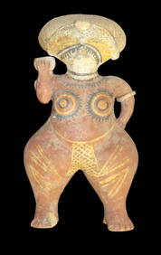
Large Human Effigy Pottery Vessel, Nicely Painted, Pre Columbian Pottery Vessle, South America. 14"Heartland Artifact Auctions Inc4.7(780)See Sold PriceFeb 25, 2024
Hand Crafted / Painted Pottery Dish Signed by "Callen Eldui La Serena Chile" South America PotteryHeartland Artifact Auctions Inc4.7(780)See Sold PriceFeb 25, 2024
1 1/2" Pre Columbian Pottery Face Effigy Head Mayan Aztec found in South AmericaHeartland Artifact Auctions Inc4.7(780)See Sold PriceFeb 25, 2024
Two Mother-of-Pearl Relicario Medallions of Jesus.Turner Auctions + Appraisals4.3(311)See Sold PriceFeb 24, 2024
4 3/16" Ancient Inca Stone Mace. South America. Motley COATony Putty Artifacts4.7(404)See Sold PriceMar 09, 2024
[UPRISING OF ENSLAVED PEOPLE]. American Eagle. No. 1. Salem, MA: Thomas C. Cushing, 5 January 1790.Freeman's | Hindman4.4(1.6k)See Sold PriceFeb 27, 2024
Collection 60 pages stamps South America and America 18-1900sBazaar of Persia4.3(23)See Sold PriceFeb 24, 2024
Map: An 18thC engraved and hand coloured map of North America and South America, titled DeClaydon Auctioneers Ltd4.3(125)See Sold PriceFeb 26, 2024
1822 MAP of NORTH & SOUTH AMERICA GEOGRAPHICAL STATISTICAL HISTORICAL antiqueJasper524.5(9.8k)See Sold PriceFeb 27, 2024
2.3/8" Pre Columbian Pottery Figurine Effigy, South America,Ex Bill Kacer FamilyHeartland Artifact Auctions Inc4.7(780)See Sold PriceMar 10, 2024
7" Jade Pre-Colombian Tirona Batwing Gorget, 2000 Yrs Old, found in Tirona Colombia South America,Heartland Artifact Auctions Inc4.7(780)See Sold PriceMar 10, 2024
5" Olmec God Effigy Pre-Colombian Pendant, South AmericaHeartland Artifact Auctions Inc4.7(780)See Sold PriceMar 10, 2024
5" Pre-Colombian Obsidian 3-sided Dagger, South AmericaHeartland Artifact Auctions Inc4.7(780)See Sold PriceMar 10, 2024
2 1/4" Pre-Colombian Human Jade Effigy, South AmericaHeartland Artifact Auctions Inc4.7(780)See Sold PriceMar 10, 2024
Blackie (Pub) 1882 Folio Print. Aborigines of South America. Brazil Patogonia Tierra del FuegoAlbion Auctions4.6(336)See Sold PriceMar 07, 2024
Mexico, Central America and West Indies Physical PoliticalJasper524.5(9.8k)See Sold PriceFeb 27, 2024


![[UPRISING OF ENSLAVED PEOPLE]. American Eagle. No. 1. Salem, MA: Thomas C. Cushing, 5 January 1790. (1 of 3)](https://p1.liveauctioneers.com/197/319238/171468013_1_x.jpg?height=282&quality=70&version=1707520367)


