ATLAS of ANTIENT GEOGRAPHY by SAMUEL BUTLER 1843John McInnis Auctioneers,LLC4.6(502)See Sold PriceFeb 24, 2024
18TH C. ANTIQUE MAP: FRENCH & INDIAN WAR, FRAMEDThomaston Place Auction Galleries4.4(386)See Sold PriceFeb 24, 2024
Rand McNally Railroad Map Cabinet w/ 21 Railroad MapsRail & Road Auctions4.6(165)See Sold PriceMar 08, 2024
Keith Haring - Ink on New York Map, Best Buddies, Inscribed, Signed, and DatedSapphire Auction Gallery4(67)See Sold PriceMar 02, 2024
LATE 17TH C. FRENCH MAP OF THE NEW WORLD BY ALEXIS-HUBERT JAILLOT (1632-1712)Thomaston Place Auction Galleries4.4(386)See Sold PriceFeb 24, 2024
Central Railroad of New Jersey Map of Sandy Hook Route-ca. 1903JM Hobby Supply and Railroad Artifact Auctions4.4(126)See Sold PriceFeb 24, 2024
Lot of Six Mixed Atlas Box Cars-HO Scale-New in BoxJM Hobby Supply and Railroad Artifact Auctions4.4(126)See Sold PriceFeb 25, 2024
Rand McNally/Santa Fe Railroad Map of Iowa-1912JM Hobby Supply and Railroad Artifact Auctions4.4(126)See Sold PriceFeb 24, 2024
NICOLAES VISSCHER (NETHERLANDS, 1618-1709) MAP OF THE NEW WORLDThomaston Place Auction Galleries4.4(386)See Sold PriceFeb 24, 2024
17TH C. WORLD MAP BY NICOLAES VISSCHER (NETHERLANDS, 1618-1709)Thomaston Place Auction Galleries4.4(386)See Sold PriceFeb 24, 2024
Lot of Six Mixed Atlas Cabooses-HO Scale-New in BoxJM Hobby Supply and Railroad Artifact Auctions4.4(126)See Sold PriceFeb 25, 2024
1764 Bellin Map of Coastal Uruguay to Iguape in Brazil -- Suite du Bresil pour Servir a l'HistoireTitle: 1764 Bellin Map of Coastal Uruguay to Iguape in Brazil -- Suite du Bresil pour Servir a l'Histoire Generale des Voyages. Cartographer: J Bellin Year / Place: 1764 c., Paris Map Dimension (in.):See Sold Price
Suite du Bresil'. Southern Brazil & Uruguay. BELLIN,TITLE OF THE MAP: 'Suite du Bresil Pour servir à l'Histoire Générale des Voyages. Villages d'Indiens et Missions Ruinées Tiré de la Carte d'Amerique de M. Danville' A map of the southern coastlinSee Sold Price
Suite du Bresil'. Southern Brazil & Uruguay. BELLIN,TITLE OF THE MAP: 'Suite du Bresil Pour servir à l'Histoire Générale des Voyages. Villages d'Indiens et Missions Ruinées Tiré de la Carte d'Amerique de M. Danville' A map of the southern coastlinSee Sold Price
Suite du Bresil'. Southern Brazil & Uruguay. BELLIN,TITLE OF THE MAP: 'Suite du Bresil Pour servir à l'Histoire Générale des Voyages. Villages d'Indiens et Missions Ruinées Tiré de la Carte d'Amerique de M. Danville' A map of the southerSee Sold Price
Suite du Bresil'. Southern Brazil & Uruguay. BELLIN,TITLE OF THE MAP: 'Suite du Bresil Pour servir à l'Histoire Générale des Voyages. Villages d'Indiens et Missions Ruinées Tiré de la Carte d'Amerique de M. Danville' A map of the southern coastlinSee Sold Price
Suite Du Bresil, 1759Map: Suite du Bresil (Brazil) Publishing: Didot, Anville, J. B. B., Paris, 1759 Size: Octavo, 9.3 x 6.75 inches Described: "pour servir a l'Histoire generale des voyages... Tire de la carte d'AmeriqueSee Sold Price
Bellin: Antique Map of North Brazil, 1758Carte du Bresil, Prem. Partie depuis la Rivière des Amazones jusqu'à la Baye de Tous les Saints. Tirée de la carte de l'Amerique de Mr. Danville Pour servir à l'Histoire Générale desSee Sold Price
MAPS - Eastern South America. BellinEastern South America. Jacques Nicolas Bellin, [Lot of 4] Carte de la Guyane, pour Servir a l'Histoire Generale des Voyages [and] Carte du Bresil, Prem. Partie... [and] Suite du Bresil... [and] SuiteSee Sold Price
Didot: Suite Du Bresil, 1758Map: Suite Du Bresil Maker: Didot, Anville, J. B. B.Date: 1758Size: Octavo, 9.25 inches high x 6.60 inches wide "depuis la Baye de Tous les Saints jusqu'a St. Paul pour servir a l'Histoire generale deSee Sold Price
Suite Du BresilPublication Date: 1759 Title: Suite Du Bresil Cartographer: ANVILLE, J. B. B. d' Publisher: DIDOT Height: 9.3 Width: 6.75 "pour servir a l'Histoire generale des voyages... Tire de la carte d'AmeriqueSee Sold Price
Sold1757 Hand Colored Engraved Map of Northern Brazil.Carte du Bresil, Prem. Partie. Depuis la Riviere des Amazones jusqu'a la Baye de Tous kes Saints, Pour Servir à l'Histoire Générale des Voyages. Appears to be the northern part of today's Brazil. DSee Sold Price
Bellin: Antique Map of Southern India, 1758TITLE OF THE MAP: 'Suite de la carte de l'Inde en deçà du Gange IIe Feuille, comprenant la Presqu'isle de l'Inde Pour servir à l'Histoire Générale des Voyages' A map of southern India and Sri LanSee Sold Price
Bellin: Map of South India Sri Lanka Ceylon, 1758TITLE OF THE MAP: 'Suite de la carte de l'Inde en deçà du Gange IIe Feuille, comprenant la Presqu'isle de l'Inde Pour servir à l'Histoire Générale des Voyages' A map of southern India and Sri LanSee Sold Price
1764 Bellin Map of the Rio de la Plata Mouth -- Carte de la Riviere de la Plata, pour Servir aTitle: 1764 Bellin Map of the Rio de la Plata Mouth -- Carte de la Riviere de la Plata, pour Servir a l'Histoire Generale des Voyages Cartographer: J Bellin Year / Place: 1764 c., Paris Map DimensionSee Sold Price
1764 Bellin Map of Brazil from the Sao Paulo Area to Salvador -- Suite du Bresil Depuis la Baye deTitle: 1764 Bellin Map of Brazil from the Sao Paulo Area to Salvador -- Suite du Bresil Depuis la Baye de Tous les Saints Jusqu'a St. Paul Cartographer: J Bellin Year / Place: 1764 c., Paris Map DimenSee Sold Price
Sold1752 Bellin Map of Japan -- Carte de lTitle/ Content of Map: 1752 Bellin Map of Japan -- Carte de l'Empire du Japon pour Servir a l'Histoire Generale des Voyages Â… Cartographer: J Bellin Year/Place: 1752, Paris Dimensions: 8.4 X 12.3See Sold Price
1754 Bellin Map of the Great Lakes Region -- Carte desTitle/Content of Map: 1754 Bellin Map of the Great Lakes Region -- Carte des Lacs du Canada pour Servir a l'Histoire Generale des Voyages Cartographer: J Bellin Year/Place: 1754 c., Paris Size: 7.7 XSee Sold Price
SoldBellin's Map of Canada and the Great Lakes Region, 1757Bellin, Jacques Nicolas. Carte des Lacs du Canada Pour servir a l' Histoire Generale des Voyages. Par M.B. Ing. de la Mar. 1757. 8 x 12 in., plate, 10 x 14.25 in., sheet. Title cartouche and lakes hanSee Sold Price
Sold1754 Bellin Map of the Great Lakes Region -- Carte desTitle: 1754 Bellin Map of the Great Lakes Region -- Carte des Lacs du Canada pour Servir a l'Histoire Generale des Voyages Date: 1754 c., Paris Medium: JBellin Size: 7.7 X 11.4 in. Additional InformatSee Sold Price
1754 Bellin Map of the Great Lakes Region -- Carte desTitle/Content of Map: 1754 Bellin Map of the Great Lakes Region -- Carte des Lacs du Canada pour Servir a l'Histoire Generale des Voyages Cartographer: J Bellin Year/Place: 1754 c., Paris Size: 7.7 XSee Sold Price
Sold1754 Bellin Map of the Great Lakes Region -- Carte desTitle: 1754 Bellin Map of the Great Lakes Region -- Carte des Lacs du Canada pour Servir a l'Histoire Generale des Voyages Cartographer: J Bellin Year/Place: 1754 c., Paris Map Dimensions (in.): 7.7 XSee Sold Price
1753 Bellin Map of the South SeasMap of the South Seas by Jacques Bellin, Paris, circa 1753. Entitled "Carte Reduite De la Mer Du Sud Pour Servir a l'Histoire generale des Voyages". Fine foldong map, close trim to right margin. MeasuSee Sold Price
1753 Bellin Map of the South SeasMap of the South Seas by Jacques Bellin, Paris, circa 1753. Entitled "Carte Reduite De la Mer Du Sud Pour Servir a l'Histoire generale des Voyages". Fine foldong map, close trim to right margin. MeasuSee Sold Price
Bresil prem partie depuis la Rivière des Amazones.TITLE OF THE MAP: 'Carte du Bresil, Prem. Partie depuis la Rivière des Amazones jusqu'à la Baye de Tous les Saints. Tirée de la carte de l'Amerique de Mr. Danville Pour servir à l'Histoire GénérSee Sold Price
LATE 17TH C. FRENCH MAP OF THE NEW WORLD BY ALEXIS-HUBERT JAILLOT (1632-1712)Thomaston Place Auction Galleries4.4(386)See Sold PriceFeb 24, 2024
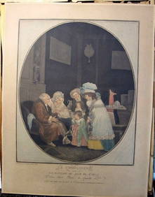
Philibert-Louis Debucourt Original Engraving Le Compliment 1787 VERY RARE!Luis Porretta Fine Arts4.3(10)See Sold PriceMar 02, 2024
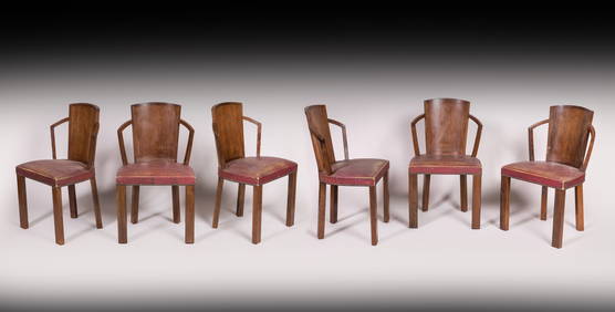
Pierre CHAREAU (1883-1950) Rare suite de huit chaises modernistes modèle « MF 275 » en placage etValoir Pousse-Cornet4.3(4)See Sold PriceFeb 24, 2024
Pierre CHAREAU (1883-1950) Table de salle à manger variante du modèle MB97 en placage et bois deValoir Pousse-Cornet4.3(4)See Sold PriceFeb 24, 2024
Roger CAPRON (1922 - 2006) : Table basse modèle "Pagode" à plateau agrémenté de carreaux deValoir Pousse-Cornet4.3(4)See Sold PriceFeb 24, 2024
Roger CAPRON (1922 - 2006) : vase diabolo en céramique émaillée. H 31 - Diam (col): 19 cm.Valoir Pousse-Cornet4.3(4)See Sold PriceFeb 24, 2024
S.A.I. MARIE N. DE RUSSIE / S.A.I. MARIE N. OF RUSSIAIEGOR Auctions4.2(133)See Sold PriceFeb 28, 2024
Duval - Pair: Map of India & Map of MaldivesTrillium Antique Prints & Rare Books4.5(30)See Sold PriceFeb 24, 2024
Linocier's L'Histoire des plantes - Volume with Numerous In Text Natural History Illustrations toTrillium Antique Prints & Rare Books4.5(30)See Sold PriceFeb 24, 2024
Karl Bodmer - A Young Mandan Indian. 24Trillium Antique Prints & Rare Books4.5(30)See Sold PriceFeb 24, 2024
Karl Bodmer - Assinboin Indians. 32Trillium Antique Prints & Rare Books4.5(30)See Sold PriceFeb 24, 2024
Karl Bodmer - Scalp Dance of the Minatarres. 27Trillium Antique Prints & Rare Books4.5(30)See Sold PriceFeb 24, 2024
1758 MAP PARTIE DE LA MER GLACIALE contenants La Nouvelle Zemble RUSSIA antiqueJasper524.5(9.8k)See Sold PriceFeb 27, 2024
L'Age de Soleil. Picasso, Godet. With one original drypoint, one of 100 copies, 1950.TheRedFinch Auctions4.4(24)See Sold PriceFeb 29, 2024
1764 Bellin Map of Lesser Antilles Northern Portion -- Petites Antilles ou Isles du Vent 3e. Partie.Jasper524.5(9.8k)See Sold PriceFeb 27, 2024
1774: AN ANTIQUE ILLUSTRATED TWO-VOLUME HISTORY OF PERUVIAN DISCOVERY AND CONQUEST WITH MAPNY Elizabeth 4.3(84)See Sold PriceMar 03, 2024
Jules Verne, L'Etoile du Sud, Au Steamer Red MacaronLion and Unicorn4.7(1.8k)See Sold PriceMar 10, 2024