ATLAS of ANTIENT GEOGRAPHY by SAMUEL BUTLER 1843John McInnis Auctioneers,LLC4.5(505)See Sold PriceFeb 24, 2024
18TH C. ANTIQUE MAP: FRENCH & INDIAN WAR, FRAMEDThomaston Place Auction Galleries4.4(393)See Sold PriceFeb 24, 2024
Rand McNally Railroad Map Cabinet w/ 21 Railroad MapsRail & Road Auctions4.6(165)See Sold PriceMar 08, 2024
Keith Haring - Ink on New York Map, Best Buddies, Inscribed, Signed, and DatedSapphire Auction Gallery4.1(67)See Sold PriceMar 02, 2024
LATE 17TH C. FRENCH MAP OF THE NEW WORLD BY ALEXIS-HUBERT JAILLOT (1632-1712)Thomaston Place Auction Galleries4.4(393)See Sold PriceFeb 24, 2024
Central Railroad of New Jersey Map of Sandy Hook Route-ca. 1903JM Hobby Supply and Railroad Artifact Auctions4.4(127)See Sold PriceFeb 24, 2024
Lot of Six Mixed Atlas Box Cars-HO Scale-New in BoxJM Hobby Supply and Railroad Artifact Auctions4.4(127)See Sold PriceFeb 25, 2024
Rand McNally/Santa Fe Railroad Map of Iowa-1912JM Hobby Supply and Railroad Artifact Auctions4.4(127)See Sold PriceFeb 24, 2024
NICOLAES VISSCHER (NETHERLANDS, 1618-1709) MAP OF THE NEW WORLDThomaston Place Auction Galleries4.4(393)See Sold PriceFeb 24, 2024
17TH C. WORLD MAP BY NICOLAES VISSCHER (NETHERLANDS, 1618-1709)Thomaston Place Auction Galleries4.4(393)See Sold PriceFeb 24, 2024
Lot of Six Mixed Atlas Cabooses-HO Scale-New in BoxJM Hobby Supply and Railroad Artifact Auctions4.4(127)See Sold PriceFeb 25, 2024
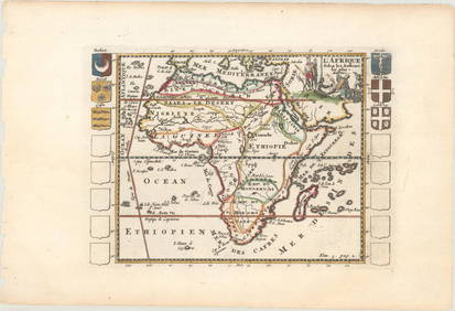
Source of the Nile map from Alain Mallet, 1685Particularly sharp example of a late 17th century regional map, showing the supposed source of the Nile River in the mountains of Dambea, Amahara and Bagmedri. The map is surprisingly accurate and preSee Sold Price
1685 map of Aegean Sea islands by Alain MalletAuthentic vintage map of the islands of Psara, Sio, Stelari, and Strongiolo in the Aegean Sea by Alain Mallet. Map is from his Description de L’Univers published in 1685, Frankfurt by Johann DavSee Sold Price
Map of the Middle East. Alain Mallets. Paris, 1683.Turquie en Asie. Map of Asiatic Turkey in the Middle East. From: Description De l'universe, Copperplate engraving. Paris, 1683. P. 207 Alain Mallet. Egypt and the Nile in the south, Syria and the CaspSee Sold Price
ABYSSINIA. Source of the Blue Nile, Ethiopia. Lake Tana. Nil. MALLET 1683 mapTITLE OF THE MAP: 'Sources du Nil' (De L'Afrique) The map shows the route and source of the Blue Nile through what is now north west Ethiopia. The province of "Goyam" (now Gojjam) is marked. The sourcSee Sold Price
NUBIA. 'Nubie'. Nile Valley. Sudan Ethiopia Egypt. MALLET 1683 old antique mapTITLE OF THE MAP: 'Nubie' (De L'Afrique) Shows the Blue Nile, although it does not indicate its source in Lake Tana. It does not show the White Nile, the source of which was not discovered until the 1See Sold Price
ABYSSINIA. East Africa. 'Abissinie' Tanzania Kenya Ethiopia. MALLET 1683 mapTITLE OF THE MAP: 'Abissinie' (De L'Afrique) The White Nile is shown (speculatively) to have sources in two lakes central Africa. Mountains of the Moon are shown. DATE PRINTED: 1683 IMAGE SIZE: ApproxSee Sold Price
Mallet: ABYSSINIA. East Africa. 'Abissinie' TanzaniaTITLE OF THE MAP: 'Abissinie' The White Nile is shown (speculatively) to have sources in two lakes central Africa. Mountains of the Moon are shown. DATE PRINTED: 1683 IMAGE SIZE: Approx Overall page sSee Sold Price
SoldEngraved Map, Alain Manesson MalletAlain Manesson Mallet (French, 1630-1706), "Du Globe Terrestre, Figure LXXV," copper engraved map with hand coloring, overall (with frame): 15"h x 12"wSee Sold Price
Engraved Map, Alain Manesson MalletAlain Manesson Mallet (French, 1630-1706), "Du Globe Terrestre, Figure LXXV," copper engraved map with hand coloring, overall (with frame): 15"h x 12"wSee Sold Price
SoldMap, Mallet, de L'Univers, 1686Map, Alain Manesson Mallet (1630-1706), Planisphere De Turovet..., circa 1686, from Description de L'Univers, copper plate engraving with a color wash, depicting the earth through various hemispheres,See Sold Price
Sold7 SMALL MAPS, CAPTAIN COOK & POLAR PROJECTIONGroup of seven hand colored and uncolored small maps including Alain Manesson Mallet polar projection map, circa 1683, four maps featuring information on Captain Cook, and two small maps of the TropicSee Sold Price
SoldMallet, Alain 1683 Map of Germany & Part of Poland"Allemagne en General" Copper Engraved Map Published 1683, Paris for "Description de l'Univers" by Alain Manesson Mallet. French text to verso. Paper Size: 8 x 5 inch (20 x 13cm) Good ConditionSee Sold Price
SoldMallet, Alain 1683 Map of France & Europe"Cerle de Bourgogne" Copper Engraved Map Published 1683, Paris for "Description de l'Univers" by Alain Manesson Mallet. French text to verso. Paper Size: 8 x 5 inch (20 x 13cm) Good ConditionSee Sold Price
SoldMallet, Alain 1683 Map of Lorraine, FranceCopper Engraved Map Published 1683, Paris for "Description de l'Univers" by Alain Manesson Mallet. French text to verso. Paper Size: 8 x 5 inch (20 x 13cm) Good ConditionSee Sold Price
SoldThe Sources Of The Nile Explorers MapsRoyal Geographic Society The Sources Of The Nile Explorers Maps 1856- 1891 A.D., reproductions of early maps of Speke, Stanley and others, 14 plates, loose as issued in cloth-backed boards, RoSee Sold Price
SoldAfrica.- Beke (Charles T.) The Sources of the Nile,Africa.- Beke (Charles T.) The Sources of the Nile, 7 maps (2 folding, 1 in text), some misbound, front free endpaper trimmed, original cloth, spine lightly faded, slight bumping to extremities, 1860See Sold Price
SoldSix Books on AfricaSix Books on Africa, A) The Sources of the Nile: Explorers' Maps A.D. 1856-1891 (London: Royal Geographical Society, 1964). R.G.S. Reproductions of Early Maps VIII. B) Judith Listowel, The Other LivinSee Sold Price
SoldBaker Albert N'yanza 1866 FirstThe Albert N'Yanza, Great Basin of the Nile, and Explorations of the Nile Sources. With Maps, Illustrations, and Portraits.by Samuel White Baker, In Two Volumes. London Macmillan 1866 First Edition. RSee Sold Price
SoldMallet, Alain 1683 Antique Map. Ancient Libya"Ancienne Libye Interievre" Copper Engraved Map Published 1683, Paris for "Description de l'Univers" First Edition by Alain Manesson Mallet. French text to verso. Paper Size: 8 x 5 inch (20 x 13cm) SoSee Sold Price
SoldMallet, Alain 1683 HC Map of Turkey in Asia, Black Sea"Turquie en Asie" Hand Coloured Copper Engraved Map Published 1683, Paris for "Description de l'Univers" by Alain Manesson Mallet. French text to verso. Paper Size: 8 x 5 inch (20 x 13cm) Good ConditiSee Sold Price
SoldMallet map of Bahamas 1685Heading: (Caribbean) Author: Mallet, Allain Manesson Title: Isles Lucayes Place Published: Paris Publisher: Date Published: c.1685 Description: Copper-engraved map/chart. 14See Sold Price
SoldMallet, Alain 1683 HC Map of Terki Fort Russia Caucasus"Tekcki" Hand Coloured Copper Engraved Map Published 1683, Paris for "Description de l'Univers" by Alain Manesson Mallet. French text to verso. Paper Size: 8 x 5 inch (20 x 13cm) Good ConditionSee Sold Price
Mallet, Alain 1683 HC Map of Terki Fort Russia Caucasus"Tekcki" Hand Coloured Copper Engraved Map Published 1683, Paris for "Description de l'Univers" by Alain Manesson Mallet. French text to verso. Paper Size: 8 x 5 inch (20 x 13cm) Good ConditionSee Sold Price
Sold2pc Alain Mallet, De L'Asie Maps. Paris, 16832pc Alain Mallet. Ancienne Region Des Sines (Figure XI) & La Chine (Figure XIII) from De L'Asie. Paris, 1683. Both maps measure 4x6'' on 8.25x5.5'' pages. B&W. Purchased from Barry Lawrence Ruderman iSee Sold Price
LARGE LATE 17TH C. DUTCH CHART OF CANADA, GREAT LAKES, NEW FRANCE, LABRADOR, HUDSON BAY, BY PIERREThomaston Place Auction Galleries4.4(393)See Sold PriceFeb 24, 2024
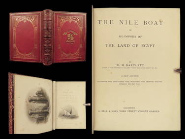
1880 Niles Boat Egypt Voyages Sphinx Pyramids Valley of Kings Illustrated MAPSSchilb Antiquarian Rare Books4.8(428)See Sold PriceMar 31, 2024
Battle of the Nile: Disposition of the English & French Fleets, at the Commencement of the Action,Trillium Antique Prints & Rare Books4.5(32)See Sold PriceFeb 24, 2024
1682 HISTORY of ETHIOPIA KINGDOM OF ABESSINIA ILLUSTRATED antique in ENGLISHJasper524.5(9.9k)See Sold PriceFeb 27, 2024
WEST AFRICA Explorers' routes Senegal Ashanti. Mountains of Kong. SDUK 1857 mapJasper524.5(9.9k)See Sold PriceFeb 28, 2024
WEST AFRICA Niger/Gambia rivers tribes towns. 'Pays des Negres'. MALLET 1683 mapJasper524.5(9.9k)See Sold PriceFeb 28, 2024
NORTH & WEST AFRICA. Sahara Niger river 'Zaara ou le Desert'. MALLET 1683 mapJasper524.5(9.9k)See Sold PriceFeb 28, 2024
AFRICA. Map pre-dating much exploration. Mountains of Kong. SDUK 1851 oldJasper524.5(9.9k)See Sold PriceFeb 28, 2024
La Barbarie de la Nigritie et de la Guinée'. West Africa. DE L’ISLE 1745 mapJasper524.5(9.9k)See Sold PriceFeb 28, 2024
WEST CENTRAL AFRICA. Congo Angola Gabon Cameroon Sao Tome. MALLET 1683 old mapJasper524.5(9.9k)See Sold PriceFeb 28, 2024
NORTH AFRICA. 'Biledulgerid', a former North African country. MALLET 1683 mapJasper524.5(9.9k)See Sold PriceFeb 28, 2024
NILE VALLEY. Upper & Lower. Egypt Sinai Nubia Sudan Abyssinia. BLACKIE 1882 mapJasper524.5(9.9k)See Sold PriceFeb 28, 2024
NUBIA. 'Nubie'. Nile Valley. Sudan Ethiopia Egypt. MALLET 1683 old antique mapJasper524.5(9.9k)See Sold PriceFeb 28, 2024
SUB-SAHARAN AFRICA. 'Ancienne Ethiopie'. Ancient Ethiopia. MALLET 1683 old mapJasper524.5(9.9k)See Sold PriceFeb 28, 2024
SOUTHERN AFRICA Monomotapa (Mutapa Kingdom) Cafrerie (Kaffraria) MALLET 1683 mapJasper524.5(9.9k)See Sold PriceFeb 28, 2024