ATLAS of ANTIENT GEOGRAPHY by SAMUEL BUTLER 1843John McInnis Auctioneers,LLC4.6(502)See Sold PriceFeb 24, 2024
18TH C. ANTIQUE MAP: FRENCH & INDIAN WAR, FRAMEDThomaston Place Auction Galleries4.4(386)See Sold PriceFeb 24, 2024
Rand McNally Railroad Map Cabinet w/ 21 Railroad MapsRail & Road Auctions4.6(165)See Sold PriceMar 08, 2024
Keith Haring - Ink on New York Map, Best Buddies, Inscribed, Signed, and DatedSapphire Auction Gallery4(67)See Sold PriceMar 02, 2024
LATE 17TH C. FRENCH MAP OF THE NEW WORLD BY ALEXIS-HUBERT JAILLOT (1632-1712)Thomaston Place Auction Galleries4.4(386)See Sold PriceFeb 24, 2024
Central Railroad of New Jersey Map of Sandy Hook Route-ca. 1903JM Hobby Supply and Railroad Artifact Auctions4.4(126)See Sold PriceFeb 24, 2024
Lot of Six Mixed Atlas Box Cars-HO Scale-New in BoxJM Hobby Supply and Railroad Artifact Auctions4.4(126)See Sold PriceFeb 25, 2024
Rand McNally/Santa Fe Railroad Map of Iowa-1912JM Hobby Supply and Railroad Artifact Auctions4.4(126)See Sold PriceFeb 24, 2024
NICOLAES VISSCHER (NETHERLANDS, 1618-1709) MAP OF THE NEW WORLDThomaston Place Auction Galleries4.4(386)See Sold PriceFeb 24, 2024
17TH C. WORLD MAP BY NICOLAES VISSCHER (NETHERLANDS, 1618-1709)Thomaston Place Auction Galleries4.4(386)See Sold PriceFeb 24, 2024
Lot of Six Mixed Atlas Cabooses-HO Scale-New in BoxJM Hobby Supply and Railroad Artifact Auctions4.4(126)See Sold PriceFeb 25, 2024
West Indies Caribbean Florida Bahamas Cuba ADMIRALTY chart 1876 (1949) old mapTITLE/CONTENT OF MAP: 'West Indian Islands and Caribbean Sea - Sheet I - Comprising Florida Strait, Bahama Islands and the Greater Antilles' DATE PRINTED: Surveyed to 1948. Published 1876. New editionSee Sold Price
West Indies Caribbean Florida Bahamas Cuba ADMIRALTY chart 1876 (1949) old mapTITLE/CONTENT OF MAP: 'West Indian Islands and Caribbean Sea - Sheet I - Comprising Florida Strait, Bahama Islands and the Greater Antilles' DATE PRINTED: Surveyed to 1948. Published 1876. New editionSee Sold Price
Cuba Bahamas Cayman Islands. Caribbean. ADMIRALTY sea chart 1907 (1949) mapTITLE/CONTENT OF MAP: 'West Indies - Cuba' DATE PRINTED: Surveyed to 1932. Published 1907. New edition 1934. Corrections to 1949 IMAGE SIZE: Approx 73.0 x 138.5cm, 28.75 x 54.5 inches (Large); PleaseSee Sold Price
Cuba Bahamas Cayman Islands. Caribbean. ADMIRALTY sea chart 1907 (1949) mapTITLE/CONTENT OF MAP: 'West Indies - Cuba' DATE PRINTED: Surveyed to 1932. Published 1907. New edition 1934. Corrections to 1949 IMAGE SIZE: Approx 73.0 x 138.5cm, 28.75 x 54.5 inches (Large); PleaseSee Sold Price
Florida Strait & Keys. Northern Cuba. ADMIRALTY sea chart 1890 (1955) old mapTITLE/CONTENT OF MAP: 'West Indies - Florida Strait - South Part' DATE PRINTED: Surveyed 1890-1931. Published 1890. New edition 1932. Corrections to 1955 IMAGE SIZE: Approx 70.5 x 111.0cm, 27.75 x 43.See Sold Price
Florida Strait & Keys. Northern Cuba. ADMIRALTY sea chart 1890 (1955) old mapTITLE/CONTENT OF MAP: 'West Indies - Florida Strait - South Part' DATE PRINTED: Surveyed 1890-1931. Published 1890. New edition 1932. Corrections to 1955 IMAGE SIZE: Approx 70.5 x 111.0cm, 27.75 x 43.See Sold Price
Havana Harbour, Cuba. Caribbean. ADMIRALTY sea chart 1954 (1955) old mapTITLE/CONTENT OF MAP: 'West Indies - Cuba - Habana Harbour' DATE PRINTED: Surveyed 1953. Published 1954. Corrections to 1955 IMAGE SIZE: Approx 85.5 x 68.0cm, 33.5 x 26.75 inches (Large); Please noteSee Sold Price
Havana Harbour, Cuba. Caribbean. ADMIRALTY sea chart 1954 (1955) old mapTITLE/CONTENT OF MAP: 'West Indies - Cuba - Habana Harbour' DATE PRINTED: Surveyed 1953. Published 1954. Corrections to 1955 IMAGE SIZE: Approx 85.5 x 68.0cm, 33.5 x 26.75 inches (Large); Please noteSee Sold Price
Jamaica. West Indies Caribbean. ADMIRALTY sea chart 1880 (1946) old mapTITLE/CONTENT OF MAP: 'West Indies - Jamaica' DATE PRINTED: Surveyed 1873-1880. Published 1880. New edition 1915. Corrections to 1946 IMAGE SIZE: Approx 69.0 x 102.5cm, 27.25 x 40.25 inches (Large); PSee Sold Price
Jamaica. West Indies Caribbean. ADMIRALTY sea chart 1880 (1946) old mapTITLE/CONTENT OF MAP: 'West Indies - Jamaica' DATE PRINTED: Surveyed 1873-1880. Published 1880. New edition 1915. Corrections to 1946 IMAGE SIZE: Approx 69.0 x 102.5cm, 27.25 x 40.25 inches (Large); PSee Sold Price
Barbuda Island. West Indies Caribbean. ADMIRALTY sea chart 1850 (1966) old mapTITLE/CONTENT OF MAP: 'West Indies - Barbuda Island' DATE PRINTED: Surveyed to 1848. Published 1850. New edition 1861. Corrections to 1966 IMAGE SIZE: Approx 68.5 x 50.5cm, 27 x 19.75 inches (Large);See Sold Price
Barbuda Island. West Indies Caribbean. ADMIRALTY sea chart 1850 (1966) old mapTITLE/CONTENT OF MAP: 'West Indies - Barbuda Island' DATE PRINTED: Surveyed to 1848. Published 1850. New edition 1861. Corrections to 1966 IMAGE SIZE: Approx 68.5 x 50.5cm, 27 x 19.75 inches (Large);See Sold Price
Kingston Harbour Port Royal Jamaica Caribbean ADMIRALTY chart 1960 (1966) mapTITLE/CONTENT OF MAP: 'West Indies - Jamaica - South Coast - Kingston Harbour including Port Royal // Ship Channel' DATE PRINTED: Surveyed 1949-1959. Published 1960. Corrections to 1966 IMAGE SIZE: ApSee Sold Price
Kingston Harbour Port Royal Jamaica Caribbean ADMIRALTY chart 1960 (1966) mapTITLE/CONTENT OF MAP: 'West Indies - Jamaica - South Coast - Kingston Harbour including Port Royal // Ship Channel' DATE PRINTED: Surveyed 1949-1959. Published 1960. Corrections to 1966 IMAGE SIZE: ApSee Sold Price
Bahamas Cat Long Islands Great Exuma Eleuthera ADMIRALTY chart 1851 (1955) mapTITLE/CONTENT OF MAP: 'West Indies - The Bahama Islands - Old Bahama Channel to Exuma' DATE PRINTED: Surveyed 1836-1943. Published 1851. New edition 1891. Corrections to 1955 IMAGE SIZE: Approx 129.0See Sold Price
Bahamas Cat Long Islands Great Exuma Eleuthera ADMIRALTY chart 1851 (1955) mapTITLE/CONTENT OF MAP: 'West Indies - The Bahama Islands - Old Bahama Channel to Exuma' DATE PRINTED: Surveyed 1836-1943. Published 1851. New edition 1891. Corrections to 1955 IMAGE SIZE: Approx 129.0See Sold Price
1850 West Indies from Mitchell atlasA fine example of Thomas Cowperthwait and S. A. Mitchell's 1854 map of West Indies. Covers from Florida and the Bahamas south through the Caribbean islands of Cuba and Hispaniola (Haiti & the DominicaSee Sold Price
1850 West Indies from Mitchell atlasA fine example of Thomas Cowperthwait and S. A. Mitchell's 1854 map of West Indies. Covers from Florida and the Bahamas south through the Caribbean islands of Cuba and Hispaniola (Haiti & the DominicaSee Sold Price
MAP - Gulf of Mexico, Cuba & Bahamas. BluntGulf of Mexico, Cuba & Bahamas. Edmund Blunt, Gulf of Mexico, West Indies, and Spanish Main, 1865 (dated). Black & White. This remarkable, large-scale, blue-backed chart covers the entire Gulf Coast oSee Sold Price
SoldOttens: Antique Map of the Caribbean / West Indies 1730Title/Content of Map: 1730 Ottens Map of the Caribbean / West Indies -- Insula Americana nempe Cuba, Hispaniola, Jamaica, Pto Rico, Lucania,Antillae vulgo Caribe barlo et Soto vento etc. Date Printed:See Sold Price
SoldEarly West Indies Map Engraving1640. by Guillaume Blaeu fine hand - colored sea chart extending from Florida to Venezuela. H15" W20 5/8" Note: full margins. map has been backed likely in the 60s. scattered minor staining near rightSee Sold Price
SoldCoronelli: Antique Map of the West Indies, 1690Map: Isole Antili, La Cuba, La Spagnuola Descritta Cartographer: Vincenzo Coronelli Place & Date: Venice / 1690 Size: 17" x 10 1/4" Condition: b&w, light overprinting and some creasing The scarce andSee Sold Price
SoldBellin: Antique Map Gulf of Mexico & West Indies, 1754Title/Content of Map: Carte du Golphe de Mexique et des Isles de l'Amerique Cartographer: Jacques Bellin Place & Date: Paris / 1754/1760 Size: 14 3/4" x 10 3/4" Condition: b&w; old folds as published;See Sold Price
Jefferys / Sayer: Antique Map of Cuba, 1775Title: The Island of Cuba with part of the Bahama Banks and the Martrys. Scarce, authoritative 1775 British map and sea chart covering most of Cuba, the Cayman Islands, the Strait of Florida, and theSee Sold Price
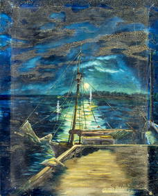
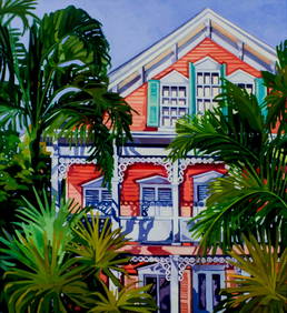
Keith Ingermann (IN,FL,1929-2012) oil paintingBroward Auction Gallery4.8(277)See Sold PriceMar 10, 2024
Keith Ingermann (IN,FL,1929-2012) oil paintingBroward Auction Gallery4.8(277)See Sold PriceMar 10, 2024
Keith Ingermann (IN,FL,1929-2012) oil paintingBroward Auction Gallery4.8(277)See Sold PriceMar 10, 2024
Americo Makk (Hawaii,NY,Hungary,1927-2015) oil paintingBroward Auction Gallery4.8(277)See Sold PriceMar 10, 2024
Union Pacific RR Across The Continent West From Omaha, NE Book-April 2, 1868JM Hobby Supply and Railroad Artifact Auctions4.4(126)See Sold PriceFeb 24, 2024
James F. Hutchinson 20C Florida Landscape PaintingHill Auction Gallery 4.7(1k)See Sold PriceFeb 28, 2024
[ARCTIC]. BOWEN, Emanuel. A New & Accurate Map of the North...Potter & Potter Auctions4.6(539)See Sold PriceMar 07, 2024
Ernesto Garcia Pena (Cuba, 1949). ink portrait drawings on paperBasel Auction House4.4(43)See Sold PriceFeb 24, 2024
West Indies. South Coast of Jamaica from Port Royal to Pedro Bluff.Jasper524.5(9.8k)See Sold PriceFeb 27, 2024
Map of Part of the West Indies, Etc., Showing the Exact Position Of The U.S. War Steamer SanJasper524.5(9.8k)See Sold PriceFeb 27, 2024
OLD MAP of the West Indies/ Carta Esperica/ 1804Churchill Galleries3.7(213)See Sold PriceFeb 26, 2024


![[ARCTIC]. BOWEN, Emanuel. A New & Accurate Map of the North... (1 of 1)](https://p1.liveauctioneers.com/928/318880/171360917_1_x.jpg?height=282&quality=70&version=1707501302)


