ATLAS of ANTIENT GEOGRAPHY by SAMUEL BUTLER 1843John McInnis Auctioneers,LLC4.5(505)See Sold PriceFeb 24, 2024
18TH C. ANTIQUE MAP: FRENCH & INDIAN WAR, FRAMEDThomaston Place Auction Galleries4.4(394)See Sold PriceFeb 24, 2024
Rand McNally Railroad Map Cabinet w/ 21 Railroad MapsRail & Road Auctions4.6(165)See Sold PriceMar 08, 2024
Keith Haring - Ink on New York Map, Best Buddies, Inscribed, Signed, and DatedSapphire Auction Gallery4.1(67)See Sold PriceMar 02, 2024
LATE 17TH C. FRENCH MAP OF THE NEW WORLD BY ALEXIS-HUBERT JAILLOT (1632-1712)Thomaston Place Auction Galleries4.4(394)See Sold PriceFeb 24, 2024
Central Railroad of New Jersey Map of Sandy Hook Route-ca. 1903JM Hobby Supply and Railroad Artifact Auctions4.4(127)See Sold PriceFeb 24, 2024
Lot of Six Mixed Atlas Box Cars-HO Scale-New in BoxJM Hobby Supply and Railroad Artifact Auctions4.4(127)See Sold PriceFeb 25, 2024
Rand McNally/Santa Fe Railroad Map of Iowa-1912JM Hobby Supply and Railroad Artifact Auctions4.4(127)See Sold PriceFeb 24, 2024
NICOLAES VISSCHER (NETHERLANDS, 1618-1709) MAP OF THE NEW WORLDThomaston Place Auction Galleries4.4(394)See Sold PriceFeb 24, 2024
17TH C. WORLD MAP BY NICOLAES VISSCHER (NETHERLANDS, 1618-1709)Thomaston Place Auction Galleries4.4(394)See Sold PriceFeb 24, 2024
Lot of Six Mixed Atlas Cabooses-HO Scale-New in BoxJM Hobby Supply and Railroad Artifact Auctions4.4(127)See Sold PriceFeb 25, 2024
Antique Map Print - Map of World - The Geographical Systems of Ptolemy, StraboTitle: Antique Map Print - Map of World - The Geographical Systems of Ptolemy, Strabo Date/Period: 1846 Dimension: 33 cm x 25 cm Material: Paper Additional Information: "The Geographical Systems of PtSee Sold Price
Antique Map Print - Map of the World - A Geographical-Hydrographic Table - 1664Title/Artist: Antique Map Print - Map of the World - A Geographical-Hydrographic Table - 1664 Date/Period: 1664 Material: Paper Dimensions: 39 cm x 58 cm Description: "A Geographical-Hydrographic TablSee Sold Price
World Mapping development. Survey coverage. Herodotus Strabo Ptolemy TIMES 1922TITLE/CONTENT OF MAP: 'Mapping of the World' DATE PRINTED: 1922 IMAGE SIZE: Approx 57.5 x 44.0cm, 22.5 x 17.25 inches (Large); Please note that this is a folding map. TYPE: Antique atlas map CONDITIONSee Sold Price
Map of Connecticut (Block Island), 1895Map of Connecticut (Block Island), 1895 Original engraving from Atlas of the World by Rand McNally, 1895. Map includes counties, geographical landmarks, streets and population data.Dimensions: 21 1/4See Sold Price
Map of Arizona, 1895Original engraving from Atlas of the World by Rand McNally, 1895. Map includes counties, geographical landmarks, streets and population data. Dimensions: 21 1/4 x 14 inches.See Sold Price
Map of Connecticut (Block Island), 1895Original engraving from Atlas of the World by Rand McNally, 1895. Map includes counties, geographical landmarks, streets and population data. Dimensions: 21 1/4" x 27 1/2"See Sold Price
Antique Map Print - World Map - Two Hemispheres - North America - South AmericaTitle/Artist: Antique Map Print - World Map - Two Hemispheres - North America - South America Date: 1778 Material: Paper Dimensions: 31,5 cm x 24 cm Additional Information: Original 1778 copper-engravSee Sold Price
Antique Map Print - Map of the World - Eduard Dumas-Vorzet - Africa, AustraliaTitle: Antique Map Print - Map of the World - Eduard Dumas-Vorzet - Africa, Australia Description: Detailed lovely world map by Eduard Dumas-Vorzet showing the discoveries by nice colors. At bottom inSee Sold Price
Antique Map Print - Map of the World - Eduard Dumas-Vorzet - Africa, AustraliaTitle/Artist: Antique Map Print - Map of the World - Eduard Dumas-Vorzet - Africa, Australia Date/Period: 1877 Material: Paper Dimensions: 28 cm x 24 cm Description: Detailed lovely world map by EduarSee Sold Price
Antique Map Print - Map of the World - Eduard Dumas-Vorzet - Africa, AustraliaTitle: Antique Map Print - Map of the World - Eduard Dumas-Vorzet - Africa, Australia Date: 1877 Material: Paper Dimensions: 11” x 9” inches / 28 cm x 24 cm Descritpion: Detailed lovely woSee Sold Price
Antique Map Print - Christian Gottlieb Reichard - Map of AmericaMap of America: Designed by Christian Gottlieb Reichard 1816. L. Hess sct. Hand Atl.No. 41. Manual atlas of all parts of the earth, according to recent conditions and of the structure of the world. NoSee Sold Price
Soldc1910 UNITED STATES CENTRAL SECTION GeographicalThis antique map is part of a large collection we are selling during this auction - check out our other auctions to view more vintage and antique maps, prints and artwork. Buy more than one item and sSee Sold Price
SoldFramed Antique Map Orbis Vetus, Robert De VaugondyItem/Description: Old print. Map of the world by Robert de Vaugondy from 1752. Orbis vetus in utraque continente : In both the old continent / world map / Vaugondy 1752. Material: Print framed under gSee Sold Price
Sold(After) Sebastian Munster (German, 1488-1552) Woodcut(After) Sebastian Munster (German, 1488-1552) Woodcut Map 16th century, hand-colored woodblock print, depicting a map of the world according to Ptolemy, surrounded by (12) wind-heads, pulled from 'CosSee Sold Price
SoldTWO ANTIQUE BENTWOOD EASELS & MAP PRINTSEasels measure approx. 21 1/8" w x 55 3/4" h. Maps are vintage reproductions of the World & Europe compliments of Sanka Coffee.See Sold Price
ANCIENT WORLD. World according to Ptolemy AD150. Sketch map. BARTHOLOMEW 1901TITLE/CONTENT OF MAP: 'The World according to Ptolemy A.D. 150' DATE PRINTED: 1901 IMAGE SIZE: Approx 12.5 x 20.0cm, 4.75 x 8 inches (Medium) TYPE: Antique map CONDITION: Good; suitable for framing. PSee Sold Price
SoldPair of map prints in antique mahogany framesPair of world maps in antique mahogany frames with gilt border. 19"h x 16 1/2"wSee Sold Price
SoldWORLD TELEGRAPH LINE MAPWORLD TELEGRAPH LINE MAP, PRINT FROM ORIGINAL C.B. & C.W. COLTON & CO. Height: 42 1/2 in. by Width: 52 in. by Depth: 2 in.See Sold Price
Sold*REPRODUCTION PRINT OF ANTIQUE MAPDepicting the world, ca. 21st C., approximately 32" x 47".See Sold Price
SoldBarlow 1807 Antique Map of The World HemispheresCopper Engraved Map Published 1807 by Brightly & Kinnersley, Bungay, England for "A General View of the World, Geographical, Historical and Philosophical" by The Rev. E. Blomfield. Maps Engraved by BaSee Sold Price
SoldBarlow 1807 Antique Map of Spain and PortugalCopper Engraved Map Published 1807 by Brightly & Kinnersley, Bungay, England for "A General View of the World, Geographical, Historical and Philosophical" by The Rev. E. Blomfield. Maps Engraved by BaSee Sold Price
SoldBarlow 1807 Antique Map of ItalyCopper Engraved Map Published 1807 by Brightly & Kinnersley, Bungay, England for "A General View of the World, Geographical, Historical and Philosophical" by The Rev. E. Blomfield. Maps Engraved by BaSee Sold Price
SoldBarlow 1807 Antique Map of North America. USA CanadaCopper Engraved Map Published 1807 by Brightly & Kinnersley, Bungay, England for "A General View of the World, Geographical, Historical and Philosophical" by The Rev. E. Blomfield. Maps Engraved by BaSee Sold Price
Carey, pub. 1796 - A Chart of the West IndiesTrillium Antique Prints & Rare Books4.5(33)See Sold PriceFeb 24, 2024
Carey, pub. 1796 - Map of the State of MarylandTrillium Antique Prints & Rare Books4.5(33)See Sold PriceFeb 24, 2024
Carey, pub. 1796 - Map of GeorgiaTrillium Antique Prints & Rare Books4.5(33)See Sold PriceFeb 24, 2024
Carey, pub. 1796 - Map of The State of South CarolinaTrillium Antique Prints & Rare Books4.5(33)See Sold PriceFeb 24, 2024
Carey, pub. 1796 - Map of KentuckyTrillium Antique Prints & Rare Books4.5(33)See Sold PriceFeb 24, 2024
Carey, pub. 1796 - Map of the Tennassee State formerly part of North Carolina (Tennessee)Trillium Antique Prints & Rare Books4.5(33)See Sold PriceFeb 24, 2024
De Jode, Rare, pub. 1593 - Map of Africa (Africae Vera Forma, et Situs)Trillium Antique Prints & Rare Books4.5(33)See Sold PriceFeb 24, 2024
SECOND WORLD WAR AFRICA. European colonies & German mandates 1940 old mapJasper524.5(9.9k)See Sold PriceFeb 28, 2024
La Barbarie de la Nigritie et de la Guinée'. West Africa. DE L’ISLE 1745 mapJasper524.5(9.9k)See Sold PriceFeb 28, 2024
Pre-SECOND WORLD WAR AFRICA. European colonies & German mandates 1942 old mapJasper524.5(9.9k)See Sold PriceFeb 28, 2024
Africa inc. discoveries of Livingstone Barth Vogel Chadda Exp. SWANSTON 1860 mapJasper524.5(9.9k)See Sold PriceFeb 28, 2024
World War 2 Europe Battle of the Atlantic 1939-43 Axis Expansion limits 1959 mapJasper524.5(9.9k)See Sold PriceFeb 28, 2024
Central Africa. Map showing great forest traversed by Mr Stanley, 1890Jasper524.5(9.9k)See Sold PriceFeb 28, 2024
Operation Torch Nov 1942-May 1943. World War 2. Western Mediterranean 1966 mapJasper524.5(9.9k)See Sold PriceFeb 28, 2024
Robert de Vaugondy - Map of Canada - Mer de l' Ouest or Sea of the West and a Northwest PassageProverde Auctions4.3(3)See Sold PriceFeb 28, 2024
Francis McNally - Antique Map of Nebraska, Kansas, Dakota, Colorado & MontanaProverde Auctions4.3(3)See Sold PriceFeb 28, 2024
Francis McNally - Antique Map of California & MinnesotaProverde Auctions4.3(3)See Sold PriceFeb 28, 2024
Francis McNally - Antique Map of Ohio, Indiana & KentuckyProverde Auctions4.3(3)See Sold PriceFeb 28, 2024
Francis McNally - Antique Map of Washington, Oregon, Idaho, Nevada, Utah & ArizonaProverde Auctions4.3(3)See Sold PriceFeb 28, 2024
Francis McNally - Antique Map of Illinois, Missouri & IowaProverde Auctions4.3(3)See Sold PriceFeb 28, 2024
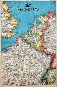
Vintage Map - Krigskarta - War Map - Second World War, published 1940Proverde Auctions4.3(3)See Sold PriceFeb 28, 2024