ATLAS of ANTIENT GEOGRAPHY by SAMUEL BUTLER 1843John McInnis Auctioneers,LLC4.6(502)See Sold PriceFeb 24, 2024
18TH C. ANTIQUE MAP: FRENCH & INDIAN WAR, FRAMEDThomaston Place Auction Galleries4.4(386)See Sold PriceFeb 24, 2024
Rand McNally Railroad Map Cabinet w/ 21 Railroad MapsRail & Road Auctions4.6(165)See Sold PriceMar 08, 2024
Keith Haring - Ink on New York Map, Best Buddies, Inscribed, Signed, and DatedSapphire Auction Gallery4(67)See Sold PriceMar 02, 2024
LATE 17TH C. FRENCH MAP OF THE NEW WORLD BY ALEXIS-HUBERT JAILLOT (1632-1712)Thomaston Place Auction Galleries4.4(386)See Sold PriceFeb 24, 2024
Central Railroad of New Jersey Map of Sandy Hook Route-ca. 1903JM Hobby Supply and Railroad Artifact Auctions4.4(126)See Sold PriceFeb 24, 2024
Lot of Six Mixed Atlas Box Cars-HO Scale-New in BoxJM Hobby Supply and Railroad Artifact Auctions4.4(126)See Sold PriceFeb 25, 2024
Rand McNally/Santa Fe Railroad Map of Iowa-1912JM Hobby Supply and Railroad Artifact Auctions4.4(126)See Sold PriceFeb 24, 2024
NICOLAES VISSCHER (NETHERLANDS, 1618-1709) MAP OF THE NEW WORLDThomaston Place Auction Galleries4.4(386)See Sold PriceFeb 24, 2024
17TH C. WORLD MAP BY NICOLAES VISSCHER (NETHERLANDS, 1618-1709)Thomaston Place Auction Galleries4.4(386)See Sold PriceFeb 24, 2024
Lot of Six Mixed Atlas Cabooses-HO Scale-New in BoxJM Hobby Supply and Railroad Artifact Auctions4.4(126)See Sold PriceFeb 25, 2024
SCANDINAVIA.Sweden Norway Denmark.Inset Christiania(Oslo);Stockholm 1898 mapTITLE/CONTENT OF MAP: 'Europe' DATE PRINTED: 1828 IMAGE SIZE: Approx 25.5 x 32.0cm, 10 x 12.5 inches (Large) TYPE: Antique copperplate map with original outline colour CONDITION: Good; suitable for frSee Sold Price
SCANDINAVIA. Norway Sweden. Baltic. Christiania/Oslo Bergen Stockholm 1920 mapTITLE/CONTENT OF MAP: 'ANCIENT MACEDONIA, THRACIA, ILLYRIA, MOESIA AND DACIA' DATE PRINTED: The map was originally published in 1830. This date is printed on the map. This edition of the map was publiSee Sold Price
An accurate map of Sweden, Denmark and Norway. BOWEN. Scandinavia 1789 oldTITLE/CONTENT OF MAP: 'Sweden & Norway; Inset maps of Christiania; Stockholm' DATE PRINTED: 1898 IMAGE SIZE: Approx 43.0 x 32.5cm, 16.75 x 12.75 inches (Large); Please note that this is a folding map.See Sold Price
Bartholomew: Map of Sweden & Norway, 1898Map: Sweden & Norway Date: 1898 From Bartholomew's "The Citizen's Atlas of the World" Size: 18 x 14 inches Please note that this lot has a confidential reserve. When you leave a bid in advance of theSee Sold Price
SCANDINAVIA.Denmark shown without North Schleswig.Norway Sweden.COLLINS 1880 mapTITLE/CONTENT OF MAP: '(Scandinavia) Sweden & Norway Denmark and the Baltic' DATE PRINTED: 1880 IMAGE SIZE: Approx 31.0 x 23.5cm, 12.25 x 9.25 inches (Large); Please note that this is a folding map. TSee Sold Price
SCANDINAVIA.Denmark shown without North Schleswig.Norway Sweden.COLLINS 1880 mapTITLE/CONTENT OF MAP: '(Scandinavia) Sweden & Norway Denmark and the Baltic' DATE PRINTED: 1880 IMAGE SIZE: Approx 31.0 x 23.5cm, 12.25 x 9.25 inches (Large); Please note that this is a folding map. TSee Sold Price
Thomson: Map of Scandinavia-Sweden Denmark Norway, 1817Title/Content of Map: 'Scandinavia, or Sweden, Denmark and Norway' The map shows Finland as part of Sweden, although Swedish rule had ended some years earlier with the conquest of Finland by Russia DaSee Sold Price
Map of Scandinavia, Sweden & Norway by Faden, 1823Map of Scandinavia including Sweden, and Norway, with The Danish Islands (which are possessions of Denmark). Map features a decorative cartouche and details towns, rivers, lakes, roads, bays, and islaSee Sold Price
1823 Map of Scandinavia, Sweden & Norway, Faden andMap of Scandinavia including Sweden, and Norway, with The Danish Islands (which are possessions of Denmark). Map features a decorative cartouche and details towns, rivers, lakes, roads, bays, and islaSee Sold Price
Map of Scandinavia, Sweden & Norway, Faden andMap of Scandinavia including Sweden, and Norway, with The Danish Islands (which are possessions of Denmark). Map features a decorative cartouche and details towns, rivers, lakes, roads, bays, and islaSee Sold Price
Map of Scandinavia, Sweden & Norway, Faden andMap of Scandinavia including Sweden, and Norway, with The Danish Islands (which are possessions of Denmark). Map features a decorative cartouche and details towns, rivers, lakes, roads, bays, and islaSee Sold Price
Map of Scandinavia, Sweden & Norway, Faden andMap of Scandinavia including Sweden, and Norway, with The Danish Islands (which are possessions of Denmark). Map features a decorative cartouche and details towns, rivers, lakes, roads, bays, and islaSee Sold Price
1823 Map of Scandinavia, Sweden & Norway, Faden andMap of Scandinavia including Sweden, and Norway, with The Danish Islands (which are possessions of Denmark). Map features a decorative cartouche and details towns, rivers, lakes, roads, bays, and islaSee Sold Price
Map of Scandinavia, Sweden & Norway, Faden andMap of Scandinavia including Sweden, and Norway, with The Danish Islands (which are possessions of Denmark). Map features a decorative cartouche and details towns, rivers, lakes, roads, bays, and islaSee Sold Price
Antique Map Print - Europe - Scandinavia - Sweden - Stockholm - Vaugondy - 1778Title/Content: Antique Map Print - Europe - Scandinavia - Sweden - Stockholm - Vaugondy - 1778 Date: 1778 Material: Paper Dimensions: 12” x 9” inches / 31,5 cm x 24 cm Description: OriginaSee Sold Price
SoldSCANDINAVIA. Sweden, Norway, and Denmark. Populations. SDUK 1857 old mapTITLE/CONTENT OF MAP: 'SWEDEN, NORWAY, AND DENMARK' DATE PRINTED: 1857 IMAGE SIZE: Approx 41.0 x 33.5cm, 16.25 x 13.25 inches (Large) TYPE: Antique steel engraved map with original hand colouring CONDSee Sold Price
SCANDINAVIA. Sweden, Norway, and Denmark. PopulationTITLE/CONTENT OF MAP: 'SWEDEN, NORWAY, AND DENMARK' Date: The map was originally published in 1841. This date is printed on the map. This edition of the map was published in 1845 IMAGE SIZE: Approx 41See Sold Price
Scandinavia, Sweden & Norway by Faden, 1823Map of Scandinavia including Sweden, and Norway, with The Danish Islands (which are possessions of Denmark). Map features a decorative cartouche and details towns, rivers, lakes, roads, bays, and islaSee Sold Price
SCANDINAVIA Sweden Norway Denmark. Baltic Sea Schleswig Holstein SDUK 1874 mapTITLE/CONTENT OF MAP: 'SWEDEN, NORWAY, AND DENMARK including the Baltic Sea and Russian Provinces adjacent' DATE PRINTED: 1874 IMAGE SIZE: Approx 41.5 x 33.5cm, 16.5 x 13.25 inches (Large) TYPE: AntiqSee Sold Price
Scandinavia, Sweden & Norway by Faden, 1823Map of Scandinavia including Sweden, and Norway, with The Danish Islands (which are possessions of Denmark). Map features a decorative cartouche and details towns, rivers, lakes, roads, bays, and islaSee Sold Price
SoldDelarochette (Louis) Scandia or ScandinaviaDelarochette (Louis) Scandia or Scandinavia,Sweden, Norway and Denmark with part of the coast of eastern Europe, extensive title vignette of fishermen, engraved map with original hand-colourinSee Sold Price
Europe. Austria-Hungary German Empire Turkey BARTHOLOMEW 1898 old antique mapTITLE/CONTENT OF MAP: 'The Baltic Sea; inset Approaches to Stockholm, Hernosand District; Sundsvall District; Soderhamn District; Goteborg; Malmo; Leningrad; Kronstadt Ship Canal; Helsinki; Lepaya; LuSee Sold Price
Antique Map of Scandinavia - Sweden - Denmark - Finland - Norway - Jean JanvierTitle: Antique Map of Scandinavia - Sweden - Denmark - Finland - Norway - Jean Janvier Date: 1762 Material: Paper Dimensions: 18” x 13” inches / 45 cm x 32 cm Descritpion: This is a stunniSee Sold Price
SCANDINAVIA. Sweden Norway.Railways.Scale in Swedish & Norwegian miles 1882 mapTITLE/CONTENT OF MAP: 'Sweden & Norway' DATE PRINTED: 1882 IMAGE SIZE: Approx 50.5 x 35.5cm, 20 x 14 inches (Large); Please note that this is a folding map. TYPE: Antique colour map CONDITION: Good; sSee Sold Price
Crams Township and Railroad Map of Pennsylvania-1898JM Hobby Supply and Railroad Artifact Auctions4.4(126)See Sold PriceFeb 24, 2024
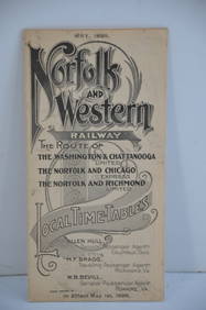
Norfolk and Western RY May 1898 Public TimetableJM Hobby Supply and Railroad Artifact Auctions4.4(126)See Sold PriceFeb 24, 2024
Assortment of Railroad Paper - Rule Books, Stationary, Ink Blotter, Map, Timetables, and MoreRail & Road Auctions4.6(165)See Sold PriceMar 07, 2024
NORTH & COLONIAL WEST AFRICA. Nigeria marked as "Royal Niger Company" 1898 mapJasper524.5(9.8k)See Sold PriceFeb 28, 2024
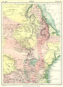
NILE VALLEY. Sudan Tanzania Ethiopia Uganda Lake Victoria. Britannica. 1898 mapJasper524.5(9.8k)See Sold PriceFeb 28, 2024
Algeria Morocco & Tunis. North Africa. Tunisia. Maghreb. BARTHOLOMEW 1898 mapJasper524.5(9.8k)See Sold PriceFeb 28, 2024
COLONIAL CENTRAL AFRICA. Congo German East Africa Rhodesia. BARTHOLOMEW 1898 mapJasper524.5(9.8k)See Sold PriceFeb 28, 2024
AFRICA. Africa. Britannica 9th edition 1898 old antique vintage map plan chartJasper524.5(9.8k)See Sold PriceFeb 28, 2024
AFRICA French Congo State Soudan Nile Delta Suez canal by GW BACON 1898 mapJasper524.5(9.8k)See Sold PriceFeb 28, 2024
Two Hand-Colored 19th Century Maps of New Orleans and Louisiana, Larger- H.- 12 1/2 in., W.- 15 1/2Crescent City Auction Gallery4.3(229)See Sold PriceMar 08, 2024
Cooke, George 1801 Antique Map. Sweden, Denmark, Norway, IcelandAlbion Auctions4.6(336)See Sold PriceMar 01, 2024
Set of 6 Lithograph Prints of Dalarna Cabinets, Nordic Textiles, and Baroque Elegance - 1800sProverde Auctions4.3(3)See Sold PriceFeb 28, 2024
Carl J. Sundevall (1801 - 1875) Set of 4 Bird Prints - Dove - Woodpecker - DuckProverde Auctions4.3(3)See Sold PriceFeb 28, 2024
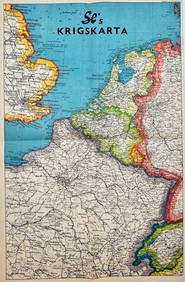
Vintage Map - Krigskarta - War Map - Second World War, published 1940Proverde Auctions4.3(3)See Sold PriceFeb 28, 2024
Jules Verne, L'Archipel en Feu, Au Steamer Red MacaronLion and Unicorn4.7(1.8k)See Sold PriceMar 10, 2024